Diastrophism refers to all processes that move, elevate, or deform the earth’s crust due to diastrophic (deforming) movements. These are also called deforming movements or slow movements. As part of the geography curriculum, students are expected to learn about slow movement and diastrophism.
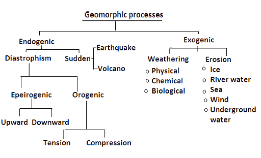
Geomorphic Processes
Slow Movements or Diastrophism
- Diastrophism refers to all processes that move, elevate, or deformation of the earth’s crust due to diastrophic movements (deforming movements) such as folding, faulting, warping (bending or twisting of a large area), and fracturing.
- Diastrophism encompasses all processes that move, elevate, or build-up sections of the earth’s crust.
- Diastrophic changes are slow and can last for thousands of years.
History Behind Slow Movements (Diastrophism)
- By the end of the nineteenth century, it was widely believed that the reason for folding and faults was lateral compression produced by the Earth’s gradual cooling, which resulted in a decreasing Earth.
- Eduard Suess proposed his eustatic hypothesis which formed the foundation for Chamberlin‘s explanation of diastrophism.
- Suess stated his conviction that the rise and fall of sea levels could be mapped over the globe over geologic time.
- Suess proposed that sea levels steadily rose as sediments filled ocean basins and that periodic events of fast ocean-bottom subsidence increased the ocean’s capacity and produced the regressions.
- Diastrophic movement, according to Chamberlin, is generated by gravitational contraction rather than thermal contraction.
- Thermal convection did not supplant the shrinking Earth hypothesis in the United States until the late 1960s.
Classifications
Diastrophic movements are further classified into epeirogenic movements and orogenic movements.
Orogenic Process
- Orogenic movements/ processes, which include mountain-building through extreme folding and influence long and narrow regions of the earth’s crust, are among them.
- Orogenic or mountain-forming movements act tangentially to the earth’s surface, as in plate tectonics. The Himalayan-Alpine orogeny is the best instance of this case.
- These processes are further classified into Tension and Compression.
- Fissures are caused by tension i.e., when force is acting away from a point in two directions.
- The Sierra Nevada (The USA) mountain range is the best example of a mountain that is formed by tension.
- Folds appear as a result of compression i.e., when force is acting towards a point.
- The Himalayas is the best example of a mountain that is formed by compression.

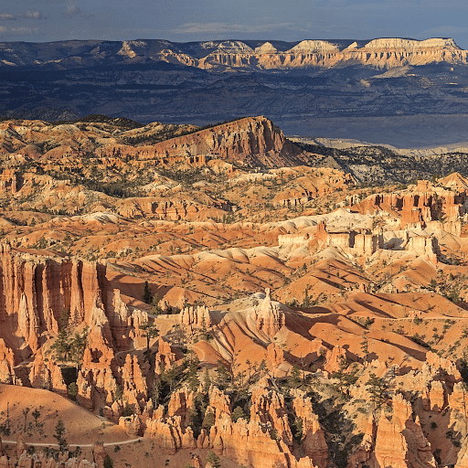
Mountain formed by Orogenic Process
Epeirogenic Process
- Movements that form continents are known as epeirogenic or continent-forming movements. They are also known as radial movements because they act along the radius of the earth.
- They can move towards (subsidence) or away from (uplift) the center.
- They create land upheavals or depressions with long-wavelength undulations (wavy surface) and little folding.
- The present-day drainage divides between Limpopo and Zambezi rivers in southern Africa is a classic example of this type.
- Subsidence occurs when movement is in a downward direction.
- It is uplifted from the center when it is away. Raised beaches, elevated wave-cut terraces, sea caves, and so on are examples of uplift
Continent Formation by Epeirogenic Processes
Epeirogenic movements are further classified into Downward and Upward.
Downward Epeirogenic Movements
- Subsidence occurs when movement is in a downward direction.
- Subsidence is evidenced by submerged forests and valleys, as well as structures.
- A section of the Rann of Kachchh was inundated due to an earthquake in 1819.
- Subsidence is evidenced by the presence of peat and lignite beds below sea level in Thirunelveli (Tamil Nadu) and the Sunderbans(West Bengal).
- The submergence of the intervening terrain has cut the Andamans and Nicobars off from the Arakan coast.
- Trees have been discovered embedded in the mud about 4 meters below the low tide line on the east side of Bombay Island. On the Thirunelveli coast in Tamil Nadu, a similar submerged forest has been discovered.
- A substantial portion of the Gulf of Mannar and Palk Strait is quite shallow and was recently submerged.
- The sea has flooded a portion of the former town of Mahabalipuram near Chennai (Madras).
Upward Epeirogenic Movements
- It is uplifted from the center when it is away. Raised beaches, elevated wave-cut terraces, sea caves, and so on are examples of uplift.
- Uplift is evidenced by elevated beaches, elevated wave-cut terraces, sea caves, and fossiliferous deposits above sea level.
- Raised beaches can be seen around the Kathiawar, Nellore, and Thirunelveli coasts, with some rising as high as 15 to 30 meters above the current sea level.
- Several locations that were once on the sea have relocated a few miles inland.
- Coringa near the Godavari’s mouth, Kaveripattinam in the Kaveri delta, and Korkai on the coast of Thirunelveli, for example, were all thriving seaports 1,000 to 2,000 years ago.
Significance of Diastrophism
Formation of Landforms
- Diastrophism is responsible for creating a range of landforms, from mountain ranges to plateaus and basins.
- For instance, the Himalayas, Alps, and Andes have formed as a result of orogenic movements.
- Epeirogenic movements can raise or lower continental blocks, leading to the formation of continental shelves or interior basins.
Influence on Climate
- The formation of mountain ranges can act as barriers to moisture-laden winds, leading to orographic rainfall on the windward side and creating rain shadows on the leeward side.
- Mountain ranges can also influence atmospheric circulation patterns and jet streams.
Biodiversity Hotspots
- Mountain ranges and highlands, often products of diastrophism, can act as isolated ecosystems leading to speciation and high biodiversity.
- For example, the Western Ghats in India, a product of tectonic forces, is one of the world’s biodiversity hotspots.
Influence on Human Settlements
- Regions uplifted due to diastrophism can influence river courses, leading to fertile plains suitable for agriculture and human settlement.
- Conversely, certain areas might become uninhabitable due to extreme elevation or rugged terrain.
Impacts on Ocean Circulation
- The rise or fall of land can influence ocean currents. For instance, the uplift of the Isthmus of Panama separated the Pacific and Atlantic Oceans, altering oceanic circulation and having global climatic implications.
Scientific Understanding
- Studying diastrophism offers insights into the Earth’s internal processes, plate tectonics, and the dynamic nature of the planet’s crust.
- It aids in understanding the Earth’s geological history and predicting future movements or changes.
Conclusion
Diastrophism plays a crucial role in shaping the Earth’s topography. The forces responsible for diastrophic movements are built up over long periods, and while they act slowly, they have immense power and can produce significant deformations in the Earth’s crust.
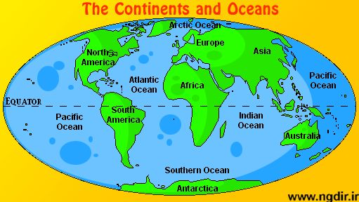
Ocean basins and continents are essential components of the Earth’s surface. They have distinct origins and characteristics that shape the planet’s topography. Here are the key points:
Ocean Basins: Ocean basins are formed through various geological processes, including the upwelling of magma and mantle materials, as well as the splitting and separation of continental crust within the Earth’s lithosphere. There are five major ocean basins on Earth:
- Atlantic Ocean: This ocean basin has a relatively straightforward ocean-floor age pattern.
- Southern Ocean: Surrounding Antarctica, this ocean is home to some of the iciest waters on Earth.
- Arctic Ocean: Located around the North Pole, the Arctic Ocean is known for its sea ice and extreme cold.
- Pacific Ocean: The largest of all ocean basins, it covers approximately 30% of Earth’s surface.
- Indian Ocean: This ocean basin is situated between Africa, Asia, and Australia.
Continents: There are seven major continents on Earth, each with its own unique characteristics. These continents are:
- Asia: The largest continent, known for its diverse landscapes and cultures.
- Europe: A continent with rich history and a mix of modern and traditional influences.
- Antarctica: The southernmost continent, primarily covered in ice and snow.
- Australia: The smallest continent, often referred to as the “island continent.”
- South America: Known for its Amazon rainforest and vibrant biodiversity.
- North America: Home to countries like the United States and Canada.
- Africa: Renowned for its diverse wildlife and vast deserts.
These continents play a significant role in the distribution of land and resources across the globe. They are also home to a wide range of ecosystems, cultures, and geological features.
CONTINENTAL DRIFT THEORY
Alfred Wegener, a German meteorologist, introduced the continental drift theory in 1912 to explain the arrangement of continents and oceans.
According to Wegener’s theory:
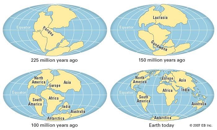
- Pangaea: Initially, all the continents were part of a single massive landmass called Pangaea, surrounded by a vast ocean named Panthalassa.
- Splitting of Pangaea: Approximately 200 million years ago, Pangaea began to split apart.
- Laurasia and Gondwanaland: The breakup of Pangaea led to the formation of two major landmasses:
- Laurasia: Positioned in the northern hemisphere, Laurasia eventually separated into several smaller landmasses.
- Gondwanaland: Located in the southern hemisphere, Gondwanaland also fragmented into numerous landmasses.
- Resulting Landmasses: From Laurasia, the following continents emerged:
- North America
- Europe
- Asia (except for the Indian subcontinent)
- From Gondwanaland, the following continents formed:
- South America
- Africa
- Indian subcontinent
- Australia
Wegener’s theory of continental drift provided a groundbreaking explanation for the current distribution of continents and oceans, even though his ideas were initially met with scepticism but later contributed to the development of the theory of plate tectonics, which is widely accepted today.
The continental drift theory is supported by various lines of evidence, including:
1. Jig-saw Fit of Continents:
- The coastlines of continents like Africa and South America seem to match and fit together, as do the coastlines of North America and Europe.
2. Rocks of the Same Age Across Oceans:
- Radiometric dating methods have shown that the age of rocks on the Brazilian coast is consistent with the age of rocks in western Africa. This suggests that there was no ocean between these continents during the Jurassic age.
3. Tillite Deposits:
- Tillite is a sedimentary rock formed by glacial deposits. The sediments in India match with sediments in six different landmasses in the southern hemisphere, including Africa, the Falkland Islands, Madagascar, Antarctica, and Australia. This indicates a shared history of glaciation.
4. Placer Deposits:
- Gold deposits in the Ghanaian coast are found, even though the source rock for gold is not present there. However, the source rock for gold is located on the Brazilian coast. This suggests that the gold deposits in Ghana originated from the Brazilian plateau, implying that Africa and South America were once part of the same landmass.
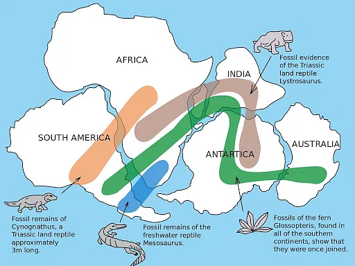
5. Distribution of Fossils:
- Similar fossils of prehistoric plants and animals are found on continents that are now widely separated by oceans. This indicates that these continents were once connected.
These lines of evidence collectively support the idea that continents were once joined together and have since drifted apart, providing the basis for the theory of continental drift.
PLATE TECTONIC THEORY
In 1967, McKenzie, Parker, and Margin introduced the concept of plate tectonics, which is based on the theories of seafloor spreading and convection currents. Plate tectonics is a fundamental framework for understanding the movement and interactions of Earth’s lithospheric plates.
Tectonic plates, also known as lithospheric plates, are massive, irregularly shaped solid pieces that can consist of either continents, oceans, or a combination of both. These plates can vary in depth, with oceanic plates ranging from approximately 5 to 100 km deep and continental plates from about 10 to 200 km deep.
Tectonic plates move horizontally over the asthenosphere, which is a semi-fluid layer beneath the lithosphere.
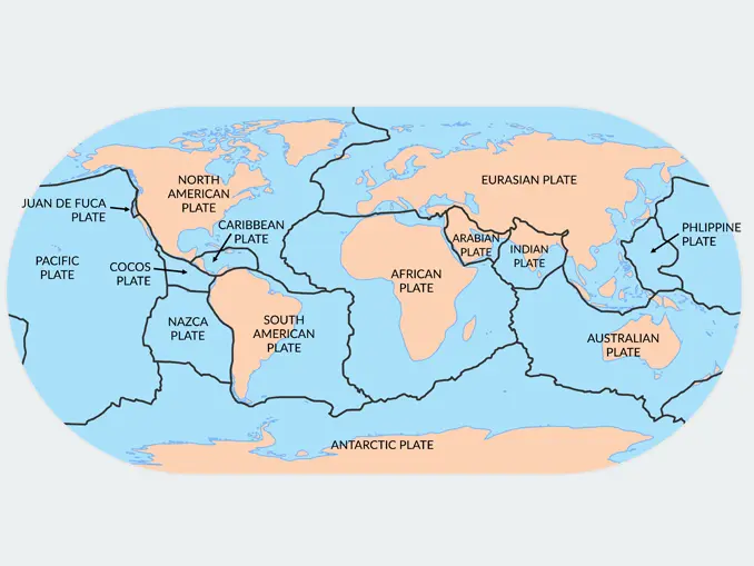
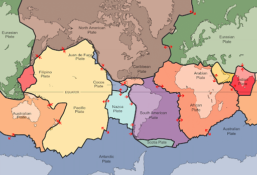
Major Tectonic Plates: There are seven major tectonic plates:
- Antarctica and surrounding ocean plates.
- North American plate.
- South American plate.
- Pacific plate.
- India, Australia, and New Zealand plate.
- Africa and the eastern Atlantic plate.
- Eurasia and adjacent ocean plates, excluding the Indian subcontinent.
It’s important to note that both continents and oceans are part of these plates, and they can move. This idea contrasts with Alfred Wegener’s earlier suggestion that only continents move.
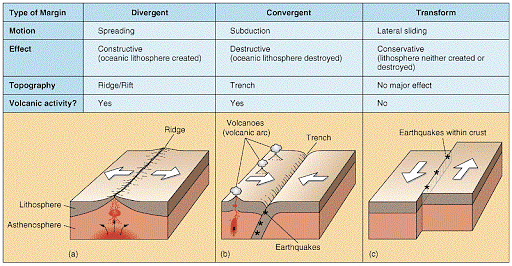
Types of Plate Boundaries: There are three main types of plate boundaries:
1. Divergent Boundaries:
- At divergent boundaries, plates move away from each other, creating new crust as magma rises to fill the gap.
- Three subtypes of divergence boundaries are:
- Ocean to ocean (e.g., Mid-Atlantic Ridge)
- Ocean to continent
- Continent to continent (e.g., Eurasian and African plates)
2. Convergent Boundaries:
- Convergent boundaries involve the collision of plates, with one plate sinking beneath the other in a process known as subduction.
- Three types of convergence can occur:
- Between an oceanic and a continental plate
- Between two oceanic plates
- Between two continental plates (e.g., Indian plate and Eurasian plate)
3. Transform Boundaries:
- At transform boundaries, plates slide past each other horizontally, causing intense geological activity, such as earthquakes.
- These boundaries do not create or destroy crust but rather redistribute it.
Understanding plate tectonics is essential for comprehending the dynamics of Earth’s surface, the formation of geological features, and the occurrence of natural disasters like earthquakes and volcanic eruptions.
The Tetrahedral Hypothesis proposed by Lothian Green in the 19th century is a fascinating theoretical model in the field of geology and Earth sciences. It posits that the Earth’s surface features, particularly its continents and ocean basins, are shaped by the planet’s tendency to approximate the geometry of a tetrahedron as it cools and contracts.
Origins and Core Concept
Lothian Green’s hypothesis emerged during an era when scientific understanding of tectonic processes was limited, and many theories attempted to explain the distribution of continents and oceans. The tetrahedron—a solid figure with four triangular faces—was seen as a natural result of the contraction hypothesis, which argued that the Earth shrank as it lost heat over geological time.
According to Green, as the Earth cooled, it would deform into a shape approximating a tetrahedron because it is the simplest and most stable polyhedral configuration that a sphere can morph into under uniform contraction. This would result in the formation of four major depressions (interpreted as ocean basins) and four elevated areas (interpreted as continents).
The theory suggested that:
- Continents represented the elevated, convex faces of the tetrahedron.
- Ocean basins occupied the depressed edges or concave corners.
Strengths and Contributions
Geometric Simplicity: The hypothesis provided a visually intuitive model to understand the global distribution of landmasses and water bodies. It attempted to bring a systematic approach to studying Earth’s surface patterns.
Focus on Cooling Dynamics: It was one of the early attempts to correlate thermal contraction with large-scale surface features, reflecting a burgeoning interest in the thermal evolution of the planet.
Historical Importance: Although later supplanted by more robust theories, the Tetrahedral Hypothesis contributed to the intellectual foundation for geophysical and tectonic studies. It inspired debates and further inquiries into the nature of Earth’s crust and mantle dynamics.
Criticisms and Limitations
Simplistic Geometric Assumptions
The Earth’s actual shape and behavior do not conform to the rigid geometric transformations proposed by the hypothesis. Earth is an oblate spheroid, and its surface dynamics are governed by highly complex processes that cannot be accurately represented by a tetrahedron.Lack of Empirical Evidence
No substantial geological or geophysical data supports the notion that continents and oceans align with the tetrahedral model. The observed distribution of continents and oceanic plates does not match the proposed tetrahedral symmetry.Neglect of Plate Tectonics
The hypothesis predates the development of plate tectonic theory, which provides a far more comprehensive and evidence-based explanation for the Earth’s surface features. Plate tectonics accounts for continental drift, seafloor spreading, and subduction zones, mechanisms absent in Green’s model.Thermal Contraction Theory Discredited
The underlying assumption that Earth’s surface features result primarily from cooling and contraction has been largely discredited. Modern geology shows that radioactive decay and internal convection currents in the mantle play significant roles in driving tectonic activity.Overgeneralization
The Tetrahedral Hypothesis oversimplifies the complex geological history of the Earth. The formation of continents and ocean basins involves tectonic collisions, volcanic activity, sedimentation, and erosion, processes that cannot be reduced to geometric deformation alone.
Modern Perspective
From a contemporary standpoint, the Tetrahedral Hypothesis is viewed as a historical curiosity rather than a viable scientific theory. It reflects the limitations of 19th-century geological science, which lacked the technological tools and data available to modern researchers. Today, satellite imaging, seismology, and paleomagnetic studies provide robust evidence supporting plate tectonics as the primary driver of Earth’s surface dynamics.
However, Green’s work is still appreciated for its role in stimulating thought and discussion. The hypothesis underscores the importance of imaginative scientific models in advancing our understanding of natural phenomena, even when those models are ultimately proven incorrect.
Conclusion
While the Tetrahedral Hypothesis of Lothian Green is no longer considered scientifically valid, it represents an important step in the historical evolution of geological thought. Its strengths lay in its ambition to explain large-scale surface features through a unifying model, but its weaknesses highlight the limitations of early scientific approaches to Earth’s structural dynamics. The development of plate tectonic theory and the dismissal of thermal contraction models have relegated the hypothesis to a historical context, but its legacy endures as a testament to the creativity and curiosity driving early Earth sciences.
The Continental Drift Theory by Wegener introduced the concept of shifting of continents for the first time in 1915. Until the early twentieth century, the continents were assumed to be fixed geographical masses. Wegener claimed that the Earth must have once been a single supercontinent before fragmenting into various continents.
Various Stages of Continental Drift Theory
Continental Drift Theory
- Continental Drift: The movement of continents across the ocean bed is known as continental drift. This drifting takes millions of years to complete this process.
- Continental drift theory was given by Alfred Wegener in 1915. This theory has explained the origin of continents and ocean basins.
- However, it was a Dutch cartographer, Abraham Ortelius, who was the first to work on the concept of symmetrical coasts on the Atlantic Ocean’s sides.
- According to Wegener, all the continents formed a single continental mass which is called “Pangaea” which means all earth. This supercontinent was surrounded by a mega ocean called “Panthalassa ” meaning all water.
- Subsequently, Laurasia and Gondwanaland continued to break into various smaller continents that exist today. Thus, Wegener proposed that continents are floating and constantly drifting on the earth’s surface.
- His hypothesis, later on, became the basis of present-day plate tectonic theory.
Various Stages of Continental Drift Theory
- First Stage: The first stage occurred during the Carboniferous period, when Pangea, a supercontinent, was encircled by Panthalassa, a mega-ocean.
- Second Stage: In the second stage around 200 million years ago in the Jurassic period, the supercontinent, Pangaea, began to split. Pangaea first broke into large continental masses as Laurasia and Gondwanaland formed the northern and southern components respectively.
- Third Stage: In the third stage, the Tethys Sea progressively filled the area between Laurasia and Gondwanaland during the Mesozoic epoch, and it gradually broadened.
- Fourth Stage: In the fourth stage around 100 million years ago when North and South America drifted westward, resulting in the emergence of the Atlantic Ocean. The Rockies and Andes were formed by the westward drift of North and South America.
- Orogenetic Stage: The Orogenetic Stage in which mountain-building activity took place is the fifth stage.
Note: The Himalayas and Alps were constructed by the folding of Tethys Sea deposits.
Forces Responsible for Continental Drift
There are two factors that are responsible for continental drift which is as follows:
- The continental drift was equatorward due to the combined action of gravitational forces, pole-fleeing force, and buoyancy force because the planet is not perfectly round and has a bulge at the equator.
- Note: The ‘pole-fleeing force’ is caused by an increase in centrifugal force from the poles towards the equator.
- The continental drift was westward due to tidal currents caused by the earth’s rotation.
- However, these two factors were eventually discovered to be insufficient reasons for continent drifting, which is considered a criticism of Wegener’s theory.
Evidence Supporting Continental Drift Theory
Alfred Wegener provided some evidence to support his theory, which is mentioned below:
- The Matching of Continents (Jig-Saw-Fit): When facing one another, the shorelines of South America and Africa form a similarity. Similarly, when matched, Africa, Madagascar, and India’s east coast all fit together.
- Rocks of Same Age Across the Oceans: Radiometric dating techniques have been used to correlate rock development across continents. It suggests that the 2,000 million-year-old strip of ancient rocks off the coast of Brazil corresponds to the mountain ranges of Western Africa.
- Similarities can also be found between the Caledonian and Appalachian mountains.
- It also implies that the early marine deposits along Africa’s and South America’s coastlines date from the Jurassic period, implying that the ocean did not exist before then.
- Tillite: Tillite is a type of sedimentary rock formed by glacier deposits. The Gondwana system of sediments from India has been discovered to have parallels in six different landmasses of the Southern Hemisphere, including Africa, the Falkland Islands, Madagascar, Antarctica, Australia, and India. It reveals that the antiquity of both landmasses was strikingly similar.
- Placer Deposits: Gold placer deposits can be discovered along the Ghana coast (West Africa). However, there is no source rock in the immediate vicinity. The fact that gold-bearing veins may be found in Brazil is incredible.
- When the two continents are laid side by side, it appears that Ghana’s gold reserves are sourced from the Brazil plateau.
- Distribution of Fossils: Identical species and animals were found on both sides of the marine barrier. For example, Mesosaurus, a freshwater crocodile-like reptile that lived between 286 and 258 million years ago, is only found in Southern Africa and Eastern South America.

Fossils remain across different continents supporting the continental drift theory
Criticisms of Continental Drift Theory
- Wegener discusses how buoyancy, tidal currents, and gravity all play a role. These, however, were insufficient to move continents.
- He favors westward or equatorial travel, but movements have occurred in all directions.
- Alfred Wegener was unable to explain the pre-carboniferous period of time. He didn’t say why the drift started in the Mesozoic era and not earlier.
- Oceans were not taken into account in the theory.
- Oceanic ridges and Island arcs were not explained by the idea.
- Large-scale motions are thought to be impossible due to the rigidity of the Earth’s crust.
- Wegener’s theories failed to provide a convincing mechanism for supporting the displacement of bigger masses during long voyages.
Conclusion
The Continental Drift Theory was rejected by the majority of scientists, and it was intensely disputed for decades following his death in 1930. The concept of conventional currents in the upper mantle was conceived in the 1920s. However, due to his early death, Alfred Wegener was unable to add the concept of conventional currents as the most compelling rationale for continental movement. Although the Continental Drift theory is no longer valid, the central premise of the theory was the driving force behind all subsequent modern hypotheses, such as plate tectonics and seafloor spreading.
Theory of Plate Tectonics suggests that Earth’s outer shell (lithosphere) is divided into several plates that glide over the Earth’s rocky inner layer above the soft core (mantle). The plates act like a hard and rigid shell compared to Earth’s mantle. According to Theory of Plate Tectonics earth’s outer crust lithosphere is divided into plates (seven major and seven minors) that move over the asthenosphere, the molten upper portion of the mantle. Plate Tectonics is responsible for various geomorphological processes such as folding, faulting etc. The theory of plate tectonics provides the necessary rationale for the distribution of oceans and continents around the globe.
Theory of Plate Tectonics
- Plate tectonics theory explains the large-scale motions of the earth’s lithosphere. The term plate was first coined by JT Wilson in 1965.
- Though this theory was proposed by Harry H. Hess in 1962 still, it was explained scientifically by other important thinkers like Morgan, Mckenzie, Parker, and Holmes.
- It is considered the most complex and comprehensive hypothesis about the drift of continents and the expansion of sea floors, and it is an improvement over Wegener’s continental drift theory.
- According to this theory, the crust of the earth is divided into several big and small fragments called plates. These lithospheric plates are about 100 km thick. These plates are floating over the semi-molten asthenosphere.
- Lithospheric plates (tectonic plates) range in size from small to significant, continental (Arabic plate) to oceanic (Pacific plate), and occasionally a combination of continental and oceanic plates (Indo-Australian plate).
- The oceanic plates are thinner and mostly made up of Simatic crust, whereas the continental plates are heavier and mostly made up of Sialic crust.
- The formation of various landforms and all earth motions are caused by the movement of these crustal plates (due to convection currents in the mantle).
- Convection currents created in the upper mantle are thought to be responsible for the movement of these plates.
- Seafloor spreading, volcanic eruptions, crustal deformation, mountain construction, and continental drift all occur along the plate borders.
Seven Major Plates
- North American plate (with the western Atlantic floor separated from the South American plate along with the Caribbean islands)
- South American plate (with western Atlantic floor separated from the North American plate along with the Caribbean islands)
- Pacific plate (Largest plate)
- Antarctica and the surrounding oceanic plate
- Eurasia and the adjacent oceanic plate
- Africa with the eastern Atlantic floor plate
- India-Australia-New Zealand plate
Minor Plates
- Caribbean Plate
- Cocos Plate
- Caroline Plate
- Juan de Fuca Plate
- Juan Fernandez micro Plate
- Iranian Plate
- South Sandwich Plate
- Myanmar Plate
- Anatolian Plate
- Nazca Plate
- Nubian Plate
- Philippines Plate
- Okhotsk Plate
- Scotian Plate
- Eastern micro Plate
- Somalian Plate
- Arabian Plate
- Solomon Plate
- Fiji Plate
- Bismarck Plate
Rate of Plate Movements
- Harry H. Hess neither explains the features of ocean floors nor the movement of the continents.
- Tectonic plates move at rates that vary from less than 6 feet per 100 years to 66 feet per 100 years (1.83–20.1 m/100 years); and these rates may have been faster in the ancient past.
- At an average rate of 33 feet per 100 years (about 10 cm/year), a tectonic plate can move 62.5 miles (about 100 km) in 1 million years.
Seafloor Spreading – Prelude to Plate Tectonics Theory
What is a Tectonic Plate?
Prelude to the Theory of Plate TectonicsThe following six developments were instrumental in the formulation of the theory of plate tectonics:
|
Types of Plate Boundaries
There are three types of plate boundaries:
Divergent Plate Boundaries
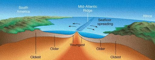
- Those plates that move away from each other consistently are called Divergent Plate Boundaries.
- This type of interaction results in the formation of mid-ocean ridges (such as the Mid-Atlantic Ridge).
- The basaltic magma erupts and separates here (seafloor spreading).
- The East African Rift Valley, produced by the divergence of the African and Somali plates, is the most important geomorphological feature on the continent.
- Divergent edges are places where the earth crust is formed (hence the name constructive edge), and volcanic earth formations are common along them.
- Along diverging margins, earthquakes (with a shallow focal) are prevalent.
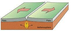
Divergent Boundary
Convergent Plate Boundaries
- When continental and oceanic plates collide, the oceanic plate, which is thinner and denser, is pushed aside by the continental plate, which is thicker and less dense.
- In a process known as “subduction,” the oceanic plate is driven down into the mantle.
- The oceanic plate is thrust into higher temperature environments as it lowers.
- Materials in the subducting plate begin to approach their melting temperatures at a depth of about 100 miles (160 kilometres), and partial melting begins.
- The most active example of continental convergent plate boundaries is the Himalayan Mountain Range.
- Around 55 million years ago, India and Asia collided, forming the Himalayas, the world’s largest mountain range.
- The Indian and Eurasian plates are colliding right now.
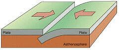
Convergent Plate Boundary
Transform Plate Boundaries
- Two plates slide past each other in this type of interaction, and no new landforms are created or destroyed; only the present landform is deformed.
- Transform faults are planes of separation in the oceans that are often perpendicular to the mid-oceanic ridges.
- The best example of a transcurrent edge on continents is the San Andreas Fault (Silicon Valley sits dangerously close to the faultline) on the western coast of the United States.
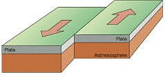
Transform Plate Boundary
Difference between Divergent, Convergent, and Transform boundaries
Evidence that Support Plate Tectonic Theory
Paleomagnetism
- The most important evidence is paleomagnetic rocks.
- The orientation of iron grains in earlier rocks is oriented to the existence of the South Pole, which was originally located somewhere between present-day Africa and Antarctica (polar wandering).
Older rocks form the continents while younger rocks are present on the ocean floor
- Rocks dating back up to 3.5 billion years have been discovered on continents, whereas the oldest rock discovered on the ocean floor is only 75 million years old (western part of Pacific floor).
- As we get closer to the ridges, we see even younger rocks.
- This indicates that the seafloor is spreading effectively along oceanic ridges, which are also plated borders.
- See floor spreading is virtually similar to plate tectonics except that it exclusively investigates the interaction between oceanic plates.
Gravitational anomalies
- The gravitational constant ‘g’ is weaker in trenches where subduction has occurred (convergent edge). This suggests that there has been a material loss.
- Gravity measurements surrounding the Indonesian islands, for example, have revealed that the oceanic trench bordering Indonesia is connected with huge gravity anomalies.
Earthquakes and Volcanoes
- The fact that all plate boundary zones are prone to earthquakes and volcanic eruptions support plate tectonics theory.
Significance of Plate Tectonics
- Plate tectonics is responsible for almost all important landforms.
- With magmatic eruptions, new minerals are thrown up from the core.
- Near the plate borders, economically valuable minerals such as copper and uranium can be discovered.
- The shape of landmasses in the future can be projected based on current knowledge of crustal plate movement.
- If current trends continue, North and South America, for example, will split. The east coast of Africa will be separated by a sliver of land. Australia will become more Asia-centric.
Theory of Plate Tectonics – Historical Background
|
Conclusion
Plate tectonics is a grand unifying geoscience theory that explains how continents move. Most significant characteristics on Earth’s surface, such as mountain construction, development of new lithosphere, consumption of old lithosphere, and mid-ocean ridges, are caused by earthquakes and volcanism.
Isostasy
- The word Isostasy is derived from the Greek word ‘iso-stasios’ which means ‘equal standing’ (in equipoise). The term isostasy was first proposed by an American geologist Clarence Dutton in 1889 to indicate the state of balance which exists between large upstanding areas of the Earth’s surface, mountain ranges and plateaus.
- The theory says that the less dense materials of the Earth’s surface (sial) must float over the denser magma (sima) of the Earth’s interior. Similarly, as we go deep interior of the Earth’s, we see that there are several concentric layers.
- The densest material forms the core whereas the Earth’s surface is composed of the lightest material. Each layer and the Earth’s surface features are resting on over another with an isostatic adjustment. For example, the average density of the Core is 13.5 gm/cm3; the density of Mantle ranges from 3.3 to 5.7 gm/cm³; density of the Continental crust is around 2.7 gm/cm³.
- The concept of Isostasy is extremely useful to explain ‘glacial adjustment’ taking place in Scandinavian countries after the Pleistocene great ice age. The raised beaches of Finland exhibit that uplift of about 250 meters has taken place during the last 8000 years due to Isostactic adjustment.
Development of the Isostasy Concept
- The concept of isostasy came in the mind of geologists but the concept grew out of the attraction of giant mountainous masses.
- Pierre Bouguer during his expedition of the Andes in 1735-45 found that the towering volcanic peak of Chimborazo was not attracting the plumb line, as it should have done. He thus maintained that the gravitational attraction of the Andes ‘is much smaller than that to be expected from the mass represented by these mountains’.
- Similar discrepancies were noted during the geodetic survey of the Indo-Gangetic plain for the determination of latitudes under the supervision of Sir, George Everest, the then Surveyor General of India in 1859. The difference of latitude of Kalianpur and Kaliana (370 miles apart) was determined by both the direct triangulation method and the astronomical method.
- Kaliana was only 96 km away from the Himalayas. The difference between two results amounted to 5.23 seconds as given bellow
- Results obtained through triangulation= 5° 23’ 42.294”.
- Results obtained through astronomical method = 5° 23’37.058”.
- Difference= 5.236”
- This discrepancy between the two methods was attributed to the less attractive of the
- Himalayas due to which the plumb bob used in the astronomical determination of latitude was deflected. There are many theories to explain the gravitational attraction and deflection and isostatic balance among the various landforms.


Concept of Sir George Airy
- According to Airy, the inner part of the mountains cannot be hollow; rather the excess weight of the mountains is compensated (balanced) by lighter materials below. According to him the crust of relatively lighter material is floating in the substratum of denser material. In other words, ‘sial’ is floating over ‘sima’.
- Thus, the Himalayas are floating in denser glassy magma. According to Airy ‘the great mass of the Himalayas was not only a surface phenomenon – the lighter rocks of which they are composed do not merely rest on the level surface of denser material beneath, but, as a boat in water, sink into the denser material.
- In other words, the Himalayas are floating in the denser magma with their maximum portion sunk in the magma in the same way as a boat floats in water with its maximum part sunk in the water. This concept in fact involves the principle of floatation.
- For example, an iceberg floats in water in such a way that for every one part to be above water level, nine parts of the iceberg remain below water level. If we assume the average density of the crust and the substratum to be 2.67 and 3.0 respectively, for every one part of the crust to remain above the substratum, nine parts of the crust must be in the substratum.
- In other words, the law of floatation demands that ‘the ratio of freeboard to draught is 1 to 9. It may be pointed out that Airy did not mention the example of the floatation of the iceberg. He simply maintained that the crustal parts (landmasses) were floating, like a boat, in the magma of the substratum.
- It we apply the law of floatation, as stated above, in the case of the concept of Airy, then we have to assume that for the 8,848 meters height of the Himalaya there must be a root, 9 times more in length than the height of the Himalaya, in the substratum. Thus, for 8,848 m part of the Himalaya above, there must be downward projection of lighter material beneath the mountain reaching a depth of 79,632m (roughly 80,000 m).
- Joly applied the principle of floatation for the crust of the Earth taking the freeboard to draught ratio as 1 to 8. According to him ‘for every emergent part of the crust above the upper level of the substratum there are eight parts submerged’. If we apply Joly’s view of floatation to the concept of Airy, there would be downward projection of the Himalaya up to a depth of 70,784m (8848m x 8) in the substratum.
- Thus, according to Airy the Himalayas were exerting their real attraction force because there existed a long root of lighter material in the substratum which compensated the material above. Based on above observation Airy postulated that ‘if the land column above the substratum is larger, its greater part would be submerged in the substratum and if the land column is lower, its smaller part would be submerged in the substratum.’
- According to Airy, the density of different columns of the land (e.g. mountains, plateaux, plains etc.) remains the same. In other words, density does not change with depth, that is, ‘uniform density with varying thickness’.

- This means that the continents are made of rocks having uniform density but their thickness or length varies from place to place. In order to prove this concept Airy took several pieces of iron of varying lengths and put them in a basin full of mercury. These pieces of iron sunk up to varying depths depending on their lengths. The same pattern may be demonstrated by taking wooden pieces of varying lengths. If we put them into the basin of water these would sink in the water according to their lengths.
- Though the concept of Sir George Airy commands great respect among the scientific community but it also suffers from certain defects and errors. If we accept the Airy’s views of isostasy, then every upstanding part must have a root below in accordance with its height.
- Thus, the Himalayas would have a root equivalent to 79,632m (if we accept the freeboard to draught ratio as 1 to 9) or 70,784m (if the freeboard to draught ratio is taken as 1 to 8). It would be wrong to assume that the Himalaya would have the downward projection of root of lighter material beneath the mountain reaching such a great depth of 79,634m or 70,784m because such a long root, even if accepted, would melt due to very high temperature prevailing there (as temperature increases with increasing depth at the rate of 1°c per 32m).

Concept of Archdeacon Pratt
- While studying the difference of gravitational deflection of 5.236 seconds during the geodetic survey of Kaliana and Kalianpur, Archdeacon Pratt calculated the gravitational force of the Himalayas after taking the average density of the Himalaya as 2.75 and came to know that the difference should have been 15.885 seconds. Pratt said that “In order to measure the angle to a star a surveyor must determine the horizontal plane if horizontal plane between two sites were askew so must be the vertical direction”.
- He, then, studied the rocks (and their densities) of the Himalayas and neighboring plains and found that the density of each higher part is less than a lower part. In other words, the density of mountains is less than the density of plateau, that of the plateau is less than the density of plain and the density of plain is less than the density of oceanic floor, and so on. This means that there is an inverse relationship between the height of the reliefs and density.
- According to Pratt, there is a level of compensation above which there is variation in the density of different columns of the land but there is no change in density below this level. Density does not change within one column but it changes from one column to other columns above the level of compensation.
- Thus, the central theme of the concept of Pratt on isostasy may be expressed as ‘uniform depth with varying density. According to Pratt equal surface area must underlie equal mass along the line of compensation. This statement may be explained with an example.


- There are two columns, A and B, along the line of compensation. Both the columns, A and B, have equal surface area but there is a difference in their height. Both the columns must have equal mass along the line of compensation, so the density of column A should be less than the density of column B so that the weight of both the columns becomes equal along the line of compensation.
- Thus, Pratt’s concept of the inverse relationship between the height of different columns and their respective densities may be expressed in the following manner- ‘bigger the column lesser the density and smaller the column, greater the density.’ According to Pratt density varies only in the lithosphere and not in the pyrosphere and barysphere.
- Thus, Pratt’s concept of isostasy was related to the ‘law of compensation and not to ‘the law of floatation.’ According to Pratt different relief features are standing only because of the fact that their respective mass is equal along the line of compensation because of their varying densities.

- Bowie has opined that though Pratt does not believe in the law of floatation, as stated by Sir George Airy but if we look, minutely, into the concept of Pratt we certainly find the glimpse of the law of floatation indirectly. Similarly, though Pratt does not believe directly in the concept of ‘root formation’ but a very close perusal of his concept on isostasy, does indicate the glimpse of such idea (root formation) indirectly.
- While making a comparative analysis of the views of Airy and Pratt on isostasy Bowie has observed that “The fundamental difference between Airy’s and Pratt’s views is that the former postulated a uniform density with varying thickness and the latter a uniform depth with varying density”.

Concept of Hayford and Bowie
- Hayford and Bowie have propounded their concepts of isostasy almost similar to the concept of Pratt. According to them there is a plane where there is complete compensation of the crustal parts. Densities vary with elevations of columns of crustal parts above this plane of compensation.
- The density of the mountains is less than the ocean floor. In other words, the crust is composed of lighter material under the mountains than under the floor of the oceans. There is such a zone below the plane of compensation where density is uniform in lateral direction.
- Thus, according to Hayford and Bowie there is inverse relationship between the height of columns of the crust and their respective densities (as assumed by Pratt) above the line of compensation. The plane of compensation (level of compensation) is supposedly located at the depth of about 100 km. The columns having the rocks of lesser density stand higher than the columns having the rocks of higher density. This statement may be understood with the help of fig below:

- There are four imaginary columns (interior plain, plateau, coastal plain, and offshore region) which reach at the level of compensation. Their height varies but they are balanced by their varying densities. ‘The assumption is that the varying volume of matter in the several columns is compensated by their density, in such a fashion that they exert equal downward pressure at the level of compensation and thus balance one another’.
- Above figure explains the above concept. It is apparent from fig. above that different columns of an equal cross-section cut from various metals and ores having varying densities are seen floating in a basin of mercury but all of them reach the same line (level of compensation) and thus exert equal weight along the line of compensation.
- Bowie made a comparative study of the views of Airy and Pratt on isostasy and concluded that there was a great deal of similarity in their views. In fact, ‘both the views appeared to him similar but not the same.’
- Bowie could observe a glimpse of the concept of root formation and law of floatation of Airy, though indirectly, in the views of Pratt. The concept of Hayford and Bowie, that the crustal parts (various reliefs) are in the form of vertical columns, is not tenable because the crustal features are found in the form of horizontal layers.
Concept of Jolly
- Joly presented his views on isostasy in the year 1925. He disapproved the view of Hayford and Bowie about the existence of a level of compensation at the depth of about 100 km on the ground that the temperature at this depth would be so high that it would cause complete liquefaction and thus level of compensation would not be possible.
- He further refuted the concept of Hayford and Bowie that ‘density varies above the level of compensation but remains uniform below the level of compensation on the ground that such condition would not be possible in practice because such condition would be easily disturbed by the geological events and thus the level of compensation would be disturbed.
- According to Joly, there exists a layer of 10-mile (16 km) thickness below a shell of uniform density. The density varies in this zone of 10-mile thickness. It, thus, Joly assumed the level of compensation as not a linear phenomenon but a zonal phenomenon. In other words, he did not believe in a ‘line (level) of compensation’ rather he believed in a ‘zone of compensation’ (of 10-mile thickness).
- Thus, we also find a glimpse of the law of floatation (it may be noted that Joly did not mention this, we only infer the idea of floatation from Joly’s concept) and his concept is closer to Airy’s concept rather than the concept of Hayford and Bowie.
- ‘This is in close agreement with floatation idea; the areas of low density in the 10-inile layer correspond with downward projections of the light continental crust, while those of high density represent the intervening areas filled with material of the heavier under stratum’.


Volcanism
- Volcanism is the eruption of molten rock from inside the Earth to the surface. Volcanism occurs because of Earth’s internal heat, and is associated with tectonic processes and a part of the rock cycle.
- Volcanic eruptions occur when molten lava reaches the surface of the Earth.
- On Earth, volcanoes are most often found where tectonic plates are diverging or converging, and most are found underwater.
Types of Volcanic Eruptions
Types of volcanic eruptions depend on various factors such as chemistry of magma, temperature, viscosity, volume, presence of groundwater, and water and gas content.
Following are the different types of volcanic eruptions:
- Hydrothermal eruption: These eruptions include ash and not magma. They are driven by the heat caused in hydrothermal systems.
- Phreatic eruption: This is driven when the heat of the magma interacts with the water. These eruptions to do not include magma and only ash.
- Phreatomagmatic eruption: This eruption takes place when there is the interaction between the newly formed magma and water.
- Strombolian and Hawaiian eruption: Hawaiian eruption has fire fountains while the Strombolian eruption has explosions due to lava fragments.
- Vulcanian eruption: These eruptions last for a short period of time and can reach up to a height of 20 km.
- Subplinian and Phinian eruptions: Subplinian eruptions reach up to 20 km height, while Plinian eruptions reach up to 20-35 km.

Types of Volcanoes
Volcanoes are grouped into four types:
- Cinder cones
- Composite volcanoes
- Shield volcanoes
- Lava volcanoes
Cinder Cones
- Cinder cones are circular or oval cones made up of small fragments of lava from a single vent that have been blown up. Cinder cones result from eruptions of mostly small pieces of scoria and pyroclastics that build up around the vent.
- Most cinder cones erupt only once. Cinder cones may form as flank vents on larger volcanoes, or occur on their own.
Composite Volcano
- Composite volcanoes are steep-sided volcanoes composed of many layers of volcanic rocks, usually made from high-viscosity lava, ash and rock debris. These types of volcanoes are tall conical mountains composed of lava flows and other ejecta in alternate layers, the strata that give rise to the name.
- Composite volcanoes are made of cinders, ash, and lava. Cinders and ash pile on top of each other, lava flows on top of the ash, where it cools and hardens, and then the process repeats.
Shield Volcano
- Shield volcanoes are volcanoes shaped like a bowl or shield in the middle with long gentle slopes made by basaltic lava flows. These are formed by the eruption of low-viscosity lava that can flow a great distance from a vent.
- They generally do not explode catastrophically. Since low-viscosity magma is typically low in silica, shield volcanoes are more common in oceanic than continental settings. The Hawaiian volcanic chain is a series of shield cones, and they are common in Iceland, as well.
Lava Domes
- Lava domes are formed when erupting lava is too thick to flow and makes a steep-sided mound as the lava piles up near the volcanic vent. They are built by slow eruptions of highly viscous lava.
- They are sometimes formed within the crater of a previous volcanic eruption. Like a composite volcano, they can produce violent, explosive eruptions, but their lava generally does not flow far from the originating vent.
Categories of Volcanoes
- Active volcanoes: An active volcano is a volcano which is either erupting or is likely to erupt in the future. There are about 600 active volcanoes in the world, most of them being around the pacific “ring of fire”.
- The Stromboli volcano erupts so much fire that it has been termed as the lighthouse of the Mediterranean.
- Dormant volcano: A dormant volcano is one that is not currently erupting but has erupted within recordable history and is expected to erupt again in the future.
- Mt Kilimanjaro is one such volcano.
- Extinct volcano: Extinct volcanoes are considered dead and are not expected to ever erupt again.
- Aconcagua of Andes is a typical example of an extinct volcano.
Volcanic Mountains
Volcanic mountains are formed as a result of volcanic activities on the surface of the Earth. The magma inside the Earth erupts out as lava through the cracks on the Earth’s surface. This cools down repeatedly to form volcanic mountains.
Example:
- Mt. Kilimanjaro(Tanzania)
- Mt. Fuji (Japan)
- Mt. Merapi (Sumatra)
- Mt. Mayon (Philippines)
- Mt. Agung (Bali)
- Mt. Cotopaxi (Ecuador)

Volcanic Landforms
Intrusive Forms
- The lava that is discharged during volcanic eruptions on cooling develops into igneous rocks.
- The cooling may take place either on arriving on the surface or also while the lava is still in the crustal portion.
- According to the location of the cooling of the lava, igneous rocks are categorized as plutonic rocks and volcanic rocks.
- The lava that cools inside the crustal portions takes diverse forms. These forms are called intrusive forms.


Extrusive landforms – Magmas that reach the surface and solidify, form extrusive landforms.

Rocks formed by either plutonic or volcanic activity are called igneous rocks.

Batholiths
- Batholiths are the cooled portion of magma chambers.
- It is a large body of magmatic material that cools in the deeper depth of the crust molds in the form of large domes.
- They appear on the surface only after the denudation processes eliminate the overlying materials.
- These are granitic bodies.
Laccoliths
- These are large dome-shaped intrusive bodies with a level base and linked by a pipe-like channel from below.
- It bears a similarity to the surface volcanic domes of the composite volcano, only these are located at deeper depths.
- It can be considered as the localized source of lava
- The Karnataka plateau is patterned with dome hills of granite rocks.
Lopolith
- When the lava moves upwards, a part of the same tends to move in a horizontal direction wherever it finds a weak plane.
- It can get rested in various forms. If it develops into a saucer shape, concave to the sky body, it is called lopolith.
Phacolith
- It is a wavy mass of intrusive rocks found at the base of synclines or the top of the anticline in the folded igneous country.
- These wavy materials have a definite outlet to source beneath in the form of magma cavities.
Sills
- The near horizontal bodies of the intrusive igneous rocks are called sill
- The thick horizontal deposits are called sills whereas the thinner ones are called sheets.
Dykes
- Dykes are the most commonly found intrusive forms in the western Maharashtra area.
- When the lava makes its channel through cracks and the fissures, it solidifies almost perpendicular to the ground.
- This gets cooled in the same position to grow a wall-like structure. Such structures are known as dykes.
- These are regarded as the feeders for the eruptions that led to the development of the Deccan traps.

