
Concept of Region in Geography
- In geography, regions are the areas that are broadly divided by its physical characteristics (physical geography), human impact characteristics (human geography), and the interaction of humanity and the environment (environmental geography).
- Geographic regions and sub-regions are mostly described by their imprecisely defined, and sometimes transitory boundaries, except in human geography, where jurisdiction areas such as national borders are defined in law.
- ‘Regions’ or ‘Landschaft’ is a similar concept that came into existence in Mid 19th centaury from the “German School”.
- At first, geographers where trying to classify the world into a natural region by the homogeneity and uniformity between physical attributes of the area or space.
- In the 20th century regions were classified into different categories ( different functional regions or planning regions) with the help of different statistical methods showing functional homogeneity in multiple attributes
- At present, the Region and regionalization get wide spectrum through the planning process in any country or a state or small unit of a natural, functional, or vernacular region of the word; to achieve the goal of sustainable development.
Definition of Region
A region is an area on the earth’s surface marked by certain properties that are homogeneous inside and distinct from outside it.
A Region is defined as a part of the Earth’s surface with one or many similar characteristics that make it unique from other areas. Regional geography studies the specific unique characteristics of places related to their culture, economy, topography, climate, politics, and environmental factors such as their different species of flora and fauna.
The concept of Region is generally linked with Space and has Spatial dimensions.
It is sometimes also used to as ‘Subjective’ (a ‘mental construct’) or ‘spaceless’. However, for most Geographers, Region is an Objective Reality linked with space, defined in terms of Space.
Sometimes a part of a District (sometimes even a village) is called Region, Sometimes a District, a State, a group of States is regarded as Region.
Some important definition given by geographers are below:
- The Region is an area of the earth Surface. – Taylor
- A region is an unit area of the earth’s surface differentiated by its specific characteristics. – F. J. Monkhouse
- The Region is a geographic area or areas which given civilisation, standard of a people seems to require for the fulfillment of the aspiration through a material resource. – C Aronovic
- Any Surface over the earth’s surface where physical conditions are homogenous is a region. – Woolfgang & Joerg
- Regions are genuine entities, each of Which expresses both natural and cultural differentiation from its neighbours. – G. T. Ranner
- “A region is a complex of land, water, air, plant, animal and man, regarded under their spatial relationship as together constituting a definite portion of the earth surface.” – A .J. Herbertson
- “A region is a domain where many dissimilar things are artificially brought together have subsequently adopted themselves to a common existence.” – Vidal-de-La-Blache
- “A region is an area of specific location which in some way very distinctive from other areas and which extends as far as the distinction extends.” – Richard Hartshorne
- “A region is an area within which the combination of environment and demographic factors have erected a homogeneity of economic and social structure.” – T.T. Woofer
- “An area throughout which a particular set of physical type of economic life.” – R.E.Dicknision
- Region is an are delineated on the basis of homogeneity of land –character, and occupance. – R.S. Platt.
Why Geographers Use regions?
Geographers study a very wide range of issues from a spatial perspective. Regions are one way to organize and simplify this vast amount of information. Even though regions are “made-up” by the geographer, they are designed in such a way that the information they provide will be useful.
Biologists do the same thing when they divide living organisms into different groups with similar characteristics to better understand the great variety of living organisms.
Development of Regional Geography
Regional geography has its roots in Europe; specifically with the French and geographer Paul Vidal de la Blanche. In the late 19th century, De la Blanche developed his ideas of the milieu and pays. The milieu was the natural environment and pays was the country or local region.
Before becoming the target of systematic concerns, regional studies sought, above all, to identify specificities, curiosities, and descriptions of the most different parts of the globe.
From the mid-eighteenth century several forms of description, classification and analysis techniques have been created without the intention to develop a more “scientific” point of view about the term region.
These concerns have become more common in the early twentieth century when the systematization of a “regional geography” began to take its first steps, both in Europe and in the United States.
Main geographers who developed the first theoretical definitions on the regional phenomenon: Alfred Hettner, in Germany, Vidal-de-la-Blache, in France, and A. J. Herbertson, in Great Britain.
The first systematic definition of the notion of the region was made by Herbertson, in an article dated 1905. With regard to its more methodological aspects, it can be said that the purpose is to create a “systematic geography“, and seeks to find “geographical divisions orders on the globe”.
The concern to define regionalization as a classification process, It makes explicit reference to the biology classification procedures (Organic theory of Regionalisation), thus demonstrating a deductive bias, based on the demarcation criteria, divides the world into major natural regions”.
Herbertson (1905) proposes four “classes of phenomena” for such regions, in the following order of importance:
- Configuration (mainly the elements of geology and geomorphology of the earth);
- Climate (air masses, temperature, and precipitation levels);
- Vegetation; and
- Population densities
Setting natural regions would be, in this sense, “the necessary step for the final solution of the problems of geography” as these definitions would allow the establishment of a sound and lasting cuts on the earth’s surface even to understand the economic functions, which each portion of the space would fulfill since it was believed that the productive activities had clear causal relationships with natural elements such as climate, geology, landform, vegetation and soil of each area. This true “physical regionalization” of the world at the time was followed by several similar attempts, mainly conducted by Russian geographers Gregg, 1974.
Paul shows that in this period the region was a fact of physical geography, a fact of nature in virtually all that was written on the subject.
Gomes (1995) also noted that “the concept of natural region is born from this idea that the environment has some ownership on the orientation of the society development.” Most of these definitions had a deterministic or “environmentalist” Bias.
Regional geography began to develop in the United States specifically and parts of Europe in the period between World Wars I and II.
During this time, geography was criticized for its descriptive nature with environmental determinism and lack of a specific focus. As a result, geographers were seeking ways to keep geography as a credible university-level subject.
In the 1920s and 1930s, geography became a regional science concerned with why certain places are similar and/or different and what enables people to separate one region from another. This practice became known as areal differentiation.
In the U.S., Carl Sauer and his Berkeley School of geographic thought led to the development of regional geography, especially on the west coast. During this time, regional geography was also led by Richard Hartshorne who studied German regional geography in the 1930s with famous geographers such as Alfred Hettner and Fred Schaefer.
Hartshorne defined geography as a science “To provide accurate, orderly, and rational description and interpretation of the variable character of the earth surface.”
For a short time during and after WWII, regional geography was a popular field of study within the discipline. However, it was later critiqued for its specifically regional knowledge and it was claimed to have been too descriptive and not quantitative enough.
The economic region was the main focus of regional research from the 1930s to the 1970s. Quite substantial results were reached in that field. During the last forty years, regional geography has ceased to appear central to most geographers. In fact, the new interest in place and territory shows a renewal in this field much more than a decline. Some geographers are, however, very critical of the regional idea.
Some Examples of Regions
- Global regions
- Continental regions
- Geographical regions
- Planning Regions
- Palaeogeographic Regions
- Physiographic Regions
- Historical Regions
- Tourism regions
- Natural regions
- Natural resource regions
- Hydrological regions
- Religious regions
- Political regions
- Socio Cultural Region
- Administrative regions
- Local administrative regions
- Traditional or informal regions
- Functional region
- Military regions
- Culture Region
- Geographical regions
Characteristics of Region
The major Characteristics of the regions are-
- A region is an area of a specific location.
- Distinctiveness: Every region is a distinct geographical area;
- Uniqueness
- Homogeneity: Homogeneity in one ore more geographical element within the boundary;
- Heterogeneity: Heterogeneity in those elements towards its regional boundaries;
- Dynamic/ Changing character: A region has dynamic character because its features where change during times; whether it is physical or human elements, single or multiple feature elements or functional or planning regions; geographical features where dynamics;
- Hierarchy: Every region has some kind of hierarchical arrangement.
- Dynamic Scale: A region can be different in scale according to its shape and size.
- Problematic: Every region have similar problems within its boundary;
- Purposive: A region is delineated for specific proposes.
- Resourceful: A region should be resourceful or have some specific resources so that they were utilized in the planning process.
Structure of Region
- Node
- Zone
- Area
Node – Here polarization or centralization of Phenomenon is found. Nodes develop in functional regions but unidentified in formal regions.
Zone – it is segment of space/part of an area where intensity and magnitude of phenomenon is maximum.
Area– It include Node + Zone + Transitional Boundaries.
Thus Region is Node + Zone + Transitional Boundaries.
Typology of Region
The three main types of regions are formal, functional, and vernacular regions.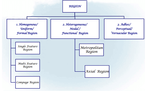
Formal Region
- A formal region is a geographical region that is homogeneous and uniform within a specified criterion. This specified criterion could be physical, social, or political. Example – Himalayan Region, Sub-Tropical Region, etc.
- A formal region is also known as a uniform or homogeneous region.
- It is an area in which everyone shares in common one or more distinctive characteristics. This common characteristic could be a cultural value such as language, an economic activity such as the production of a certain crop, or an environmental property such as climate and weather patterns. Whatever the common characteristic is, it is present throughout the selected region.
- In certain formal regions, the characteristic may be predominant rather than universal, such as the wheat belt in North America, it is an area in which the predominant crop is wheat, but other crops are grown here as well.
- Its is further divided in ‘Single feature Region ‘(ex. Physiographic regions of India),“Multiple Feature region’ (ex. Resource Region or Planning region), and ‘Compage region’ (ex. Agricultural region of the World).
- Whittlessy (1956) defined ‘compage region’ as a uniform region where all the features of the physical, biotic and social environment are functionally associated with the human occupance.
Functional Region
- A functional region that displays a certain functional coherence, an interdependence of parts when defined on the basis of certain criteria is known as a functional region.
- A functional region, also known as a nodal region, organized around a node or focal point. It is sometimes referred as a polarized region and is composed of heterogeneous units such as cities, towns & villages which are functionally inter-related. Example – National Capital Region.
- The characteristic chosen to define a functional region dominates at a central focus or node and diminishes in importance outward.
- The region is tied to the central point by transportation, communication systems or by economic or functional associations.
- The functional linkage keep in changing in nature and volume.
- An example of a functional region is the circulation area of a newspaper. That area is centered around the city in which the newspaper is published in. The farther away from the city of circulation, the less people that read the newspaper (this phenomenon is known as distance decay).
Vernacular Region
- A “vernacular region” is a distinctive area where the inhabitants collectively consider themselves interconnected by a shared history, mutual interests, and a common identity. Such regions are “intellectual inventions” and a form of shorthand to identify things, people, and places.
- Vernacular regions reflect a “sense of place,” but rarely coincide with established jurisdictional borders.
- A vernacular region, also known as Perceptual region or Adhoc Region, is a place that people exist as part of their cultural identity.
- These regions vary from person to person. They emerge from a person’s informal sense of place. An example of a vernacular region would be the Cultural region or Transitional regions, depressed areas, etc.
Geography, as a field of study, seeks to understand the spatial dimensions of Earth’s phenomena and human interactions. It is traditionally divided into two main branches: systematic geography and regional geography. These branches differ in their approaches but are complementary to one another. Their combined methodologies provide a comprehensive understanding of geographical phenomena.
Defining Systematic and Regional Geography
Systematic geography focuses on studying specific geographical phenomena in isolation, applying general principles that can be observed across various locations. It examines elements like climatology, geomorphology, economic activities, population trends, and cultural practices on a global or universal scale. For example, in climatology, systematic geography might study the general principles of weather patterns, climate classification, or atmospheric circulation.
On the other hand, regional geography emphasizes the unique characteristics of specific areas or regions. It integrates various systematic phenomena to understand the spatial uniqueness of a location. A region can be defined based on physical attributes, such as the Himalayan region, or cultural and economic parameters, like the European Union. Regional geography seeks to offer a holistic analysis, blending physical, human, and environmental aspects of a specific area to highlight what makes it distinct.
Complementary Methodologies
The distinction in their methodologies underlines their complementary nature. Systematic geography adopts a thematic and generalizing approach, creating a framework that explains how and why phenomena occur. For instance, systematic geography provides models such as the Von Thünen Model of Agricultural Land Use or the Central Place Theory, which explain general patterns of land use and settlement. These principles are universal and apply to multiple locations, forming the foundation upon which regional geographers base their analysis.
Regional geography, by contrast, applies these systematic principles within the context of a specific area. While systematic geography identifies broad patterns (e.g., the effects of trade winds globally), regional geography examines how these patterns manifest in a particular region (e.g., the influence of trade winds on the Sahara Desert). This synthesis offers a nuanced understanding of individual regions, enriched by the principles derived from systematic studies.
Case Studies: Systematic and Regional Approaches
Climatology and Regional Impacts
A systematic geographer studying climatology might analyze the mechanisms behind monsoon systems globally. They would identify general patterns like the interplay between high-pressure and low-pressure systems and the influence of the Intertropical Convergence Zone (ITCZ). Meanwhile, a regional geographer might study how the monsoon impacts South Asia, specifically its influence on agriculture, water availability, and cultural practices in India. The regional analysis enriches the systematic perspective by contextualizing it within a specific area.
Economic Geography
Systematic geography in the field of economic activities might study the global division of labor or patterns of industrial location. Theories such as Weber’s Least Cost Theory or Rostow’s Stages of Economic Growth provide a broad understanding of industrial development. Regional geography, however, examines how these theories manifest in specific regions—e.g., how the Silicon Valley in California emerged as a hub for the IT industry due to factors like skilled labor, venture capital, and cultural innovation.
Interdependence: Theoretical and Practical Applications
Systematic and regional geography are interdependent and mutually reinforcing. Systematic geography lays the foundation for theoretical understanding by establishing general principles, while regional geography validates and contextualizes these principles in real-world settings.
Validation of Theories: Systematic principles are tested and refined through regional studies. For instance, the theory of plate tectonics (a systematic principle) is understood in detail through its regional manifestations, such as the formation of the Andes Mountains or the Himalayan uplift.
Policy and Planning: Regional geography often informs practical applications such as urban planning, resource management, and disaster mitigation. These solutions are guided by systematic principles but adapted to regional contexts. For example, while flood management principles are broadly understood, their application differs in the Netherlands (focused on dike construction and water pumping) versus Bangladesh (emphasizing flood-resistant infrastructure and community resilience).
Integration of Human and Physical Geography: Regional geography achieves a holistic synthesis by integrating findings from various systematic subfields. For example, understanding the Amazon Basin requires insights from physical geography (rainfall patterns, biodiversity) and human geography (indigenous cultures, deforestation impacts).
Criticism and the Need for Complementarity
Critics of systematic geography argue that it sometimes oversimplifies by focusing on generalizations and ignoring local variations. Similarly, regional geography can be criticized for its lack of universality, as it often relies on descriptive analysis without contributing to broader theoretical frameworks. However, these limitations are addressed when the two approaches work in tandem.
For instance, systematic geography’s emphasis on urbanization patterns may overlook the unique socio-cultural factors shaping urban growth in a specific region like Sub-Saharan Africa. Regional geography bridges this gap by analyzing local contexts, such as the influence of tribal structures or informal economies, thereby complementing systematic findings.
Conclusion
Systematic and regional geographies are not competing frameworks but rather two sides of the same coin. Systematic geography provides the theoretical underpinnings and broad principles necessary to understand global phenomena, while regional geography applies these principles to specific contexts, enriching and validating systematic knowledge. Together, they offer a comprehensive and nuanced understanding of the Earth’s physical and human landscapes. Their complementarity underscores the strength of geography as a discipline, enabling it to balance universality with specificity and theoretical rigor with practical application. By integrating both approaches, geographers can address complex global challenges with a deeper understanding of their local manifestations.
A region is a part of the earth’s surface that is characterized by a level of similarity based on certain features. They are defined by the scale of physical characteristics and human characteristics. In geography, regions are categorized into three: formal, functional and vernacular. Formal regions are politically defined regions such as countries, states, and cities. A region that is specifically divided or located for a function is called a functional region. This is the main difference between formal and functional regions.
What is a Formal Region?
A formal region is a specific area that is defined by economics, physical properties, culture or government. A formal region is also known as a uniform region as it shares one or more physical or cultural features. Such formal locations are called uniform since they are combined with, uniform soil and uniform climate that result in uniform land use, settlements and mode of life within a region.
What is a Functional Region?
A region that is specifically divided or located for a function is called a functional region. A functional region is made up of a specific location and area surrounding it. Areas containing a kind of service, such as cable television, or points on a map that are a terminal for an activity, such as travel or communication via telephone can also be named as functional regions.
What is the difference between Formal and Functional Regions?
Formal Region | Functional Region |
|
|
|
|
|
|
|
|
|
|
|
|
|
|
|
|
|
|
Examples: States, Countries, Cities, Counties and Provinces |
|
|
|
Conclusion
Formal and functional regions both have a social, cultural and political system, along with its living population. A formal region is an area identified by a political and social system and a functional system is an area, where we find a particular function taking place like for an example; electronic production, newspaper circulation etc. Both these terms are merely man-made definitions to facilitate the governing and growth of one specific area with the vision of achieving higher status in terms of the economic, social, cultural and political growth of one’s country.
The concept of regions is central to geography, as it allows for the categorization of areas based on shared characteristics. Among the many types of regions, natural regions and cultural regions stand out as fundamental classifications. These two types of regions differ in their defining characteristics, origins, boundaries, and dynamics, reflecting the interplay between the natural environment and human activity.
Defining Natural and Cultural Regions
A natural region is an area defined by physical and environmental characteristics, such as climate, landforms, vegetation, and natural resources. These regions emerge from the interaction of Earth’s physical processes, which shape their unique natural attributes. For instance, the Sahara Desert, characterized by arid climate and sparse vegetation, is a natural region. Such regions are usually stable over time unless altered by significant natural events like volcanic eruptions or human-induced changes like deforestation.
In contrast, a cultural region is defined by human activity and cultural characteristics, including language, religion, ethnicity, economic activities, and social practices. These regions are shaped by historical processes, human interaction, and the diffusion of cultural traits. For example, the Middle East, often identified as a cultural region, is unified by shared religious traditions (predominantly Islam), language (Arabic as a lingua franca), and historical identity.
Key Characteristics of Natural and Cultural Regions
Basis of Formation
Natural regions are formed by environmental factors, such as climate zones (tropical, temperate, polar), biomes (forests, grasslands, deserts), or geological features (mountain ranges, plateaus). They are typically delineated through scientific methods, such as climate classification systems like the Köppen Climate Classification.Cultural regions, on the other hand, are based on human constructs. They emerge from the shared practices, beliefs, and traditions of human populations. For instance, the Latin American cultural region includes countries in South and Central America that share a common colonial heritage, languages (Spanish and Portuguese), and predominantly Catholic traditions.
Boundaries
The boundaries of natural regions are often more precise and fixed, determined by observable physical factors. For instance, the boundary of the Amazon Rainforest can be delineated based on vegetation types and climatic conditions. These boundaries may shift over time due to natural phenomena like desertification or glacial melting but are generally stable in the short term.In contrast, the boundaries of cultural regions are often fluid and subjective, shaped by historical, political, and social changes. For example, the boundaries of the Islamic cultural region are not strictly geographical but depend on the spread of Islamic faith and cultural practices, which vary in intensity across countries and even within them.
Homogeneity vs. Diversity
Natural regions exhibit greater environmental homogeneity within their boundaries. For example, the Tundra region is characterized by permafrost, low temperatures, and specific flora and fauna, offering a consistent physical environment.Cultural regions, however, often exhibit significant internal diversity, as cultural traits are influenced by local variations in tradition, language, or religion. For instance, while Europe is often considered a cultural region due to its shared history, values, and economic integration, it includes diverse sub-regions such as Southern Europe (characterized by Mediterranean culture) and Northern Europe (with Scandinavian influences).
Dynamics and Evolution
Natural regions evolve slowly, driven by geological or climatic changes. For instance, the Sundarbans mangrove forests in India and Bangladesh are shrinking due to rising sea levels caused by climate change, altering their natural boundaries.Cultural regions are more dynamic and responsive to human activities, including migration, globalization, and technological advancements. For example, the Silicon Valley cultural region in California emerged in the 20th century due to technological innovation and economic activities, reflecting the rapid evolution of cultural regions.
Examples of Natural and Cultural Regions
Natural Regions
- The Amazon Basin: A vast natural region defined by the Amazon River system, tropical rainforest vegetation, and a hot, humid climate. It is home to diverse ecosystems and unique species like jaguars and anacondas.
- The Himalayas: A natural region characterized by towering mountain peaks, glacial systems, and alpine ecosystems. This region influences climate patterns such as the monsoon and serves as the source of major rivers like the Ganges and Brahmaputra.
Cultural Regions
- The Islamic World: Spanning North Africa, the Middle East, and parts of Asia, this cultural region is defined by the predominance of Islam, shared religious practices, and similar social customs, despite linguistic and ethnic diversity.
- The Anglo-American Cultural Region: Comprising the United States and Canada, this region is unified by the dominance of English language, democratic governance, and shared historical ties to Britain, though it includes ethnic and linguistic minorities.
Interconnection Between Natural and Cultural Regions
While natural and cultural regions are distinct in their characteristics, they are deeply interconnected. Natural regions often influence the formation of cultural regions, and cultural activities can, in turn, reshape natural regions.
Natural Influence on Cultural Regions
The natural environment often dictates the lifestyle, economy, and social structures of human populations, thereby shaping cultural regions. For instance, the Nile Valley in Egypt emerged as a cultural region due to the fertile plains created by the river’s annual flooding, which supported agriculture and sustained ancient Egyptian civilization. Similarly, the Arctic cultural region, home to Indigenous groups like the Inuit, reflects adaptations to the harsh tundra environment.Cultural Impact on Natural Regions
Human activities often modify natural regions, leading to changes in their boundaries and characteristics. For instance, the Indo-Gangetic Plain, once a natural floodplain, has been heavily modified by agricultural practices and urbanization, creating a cultural region defined by intensive farming and dense population.Conflicts and Interactions
The overlap between natural and cultural regions can lead to conflicts and challenges. For example, the Amazon Basin is a natural region under threat due to deforestation driven by cultural activities like cattle ranching and logging. Similarly, the cultural practice of industrialization has significantly altered natural regions like the Great Lakes in North America, causing pollution and biodiversity loss.
Conclusion
Natural and cultural regions represent two fundamental ways of understanding the world. Natural regions, grounded in environmental and physical attributes, provide a foundation for studying the Earth’s physical processes. Cultural regions, shaped by human activities and interactions, highlight the diversity and complexity of human societies. While their distinctions lie in their origins, defining characteristics, and boundaries, their interconnections underscore the inseparability of nature and culture. Together, they offer a comprehensive framework for analyzing the dynamic relationship between humans and the environment, enabling geographers to address contemporary challenges such as climate change, resource management, and cultural preservation.
Economic regions are fundamental to the study of human geography, economics, and regional planning. These regions are defined by the economic activities, interactions, and dependencies that characterize specific geographical areas. They are shaped by a combination of natural resources, infrastructure, labor markets, and economic policies, reflecting the dynamic relationship between the physical environment and human endeavors.
Defining Economic Regions
An economic region is a geographic area distinguished by its economic activities, which may include agriculture, industry, trade, services, or natural resource utilization. These regions may correspond to political or administrative boundaries, such as a country or state, or transcend them, reflecting economic integration on a broader scale. For instance, the European Union (EU) functions as a supranational economic region, integrating the economies of its member states through trade agreements, a common currency for most members, and shared economic policies.
Economic regions can be categorized into various types, such as agrarian regions, industrial regions, trade and financial hubs, or mixed-economy regions, depending on the dominant economic activity.
Criteria for Defining Economic Regions
Economic regions are delineated based on a set of criteria that highlight their unique economic characteristics. These criteria include:
Dominant Economic Activity
Economic regions are often classified according to the type of economic activity that predominates within the area. For example, the Corn Belt in the United States is recognized for its agricultural output, particularly maize and soybean cultivation. Similarly, the Ruhr Industrial Region in Germany is known for its concentration of heavy industries, including steel production and coal mining.Resource Base
The availability and exploitation of natural resources play a critical role in defining economic regions. Resource-rich areas like the Middle East, known for its vast oil reserves, are categorized as energy-producing regions. In contrast, regions with limited natural resources, such as Japan, have evolved into industrial and technological hubs by leveraging human capital and innovation.Infrastructure and Connectivity
The presence of transportation networks, ports, and communication infrastructure is a key criterion for defining economic regions. For example, the Silicon Valley in California has become a global hub for technology and innovation due to its world-class research institutions, skilled workforce, and excellent connectivity. Similarly, the Golden Quadrilateral in India links major industrial and economic centers through a well-developed road network.Labor Market and Workforce Characteristics
Economic regions often reflect the availability and specialization of the labor force. For instance, the Bangalore Metropolitan Region in India has become a leading center for information technology due to its skilled workforce and supportive policies. In contrast, the Deccan Plateau, historically an agrarian region, reflects the labor force’s engagement in farming and related activities.Trade Networks and Economic Interdependence
The degree of trade integration and economic interdependence also defines economic regions. For example, the North American Free Trade Agreement (NAFTA), now replaced by the USMCA (United States-Mexico-Canada Agreement), created an economic region characterized by extensive trade and investment flows among the three countries.Political and Institutional Framework
Economic policies, governance structures, and institutional support significantly influence the delineation of economic regions. For example, the ASEAN Economic Community in Southeast Asia represents a region that fosters economic cooperation among its members through coordinated trade, investment, and regulatory policies.
Characteristics of Economic Regions
Economic regions are marked by distinct characteristics that reflect their economic structures, interactions, and growth dynamics.
1. Specialization and Comparative Advantage
Economic regions often exhibit specialization in specific industries or sectors, driven by comparative advantages such as natural resources, labor skills, or technological expertise. For instance, the Appalachian Region in the United States historically specialized in coal mining, while the Great Plains became a breadbasket for wheat production due to its fertile soils and suitable climate.
2. Economic Integration
Integration within an economic region is characterized by the interdependence of its various components. This can be observed in regions like the EU, where member countries share a common market and harmonized trade policies, facilitating the free flow of goods, services, and labor.
3. Urbanization and Industrial Clusters
Economic regions often feature significant urbanization and the development of industrial clusters, where related industries co-locate to benefit from shared infrastructure, labor, and knowledge exchange. For example, the Detroit Metropolitan Region in the United States became synonymous with automobile manufacturing due to the clustering of companies like Ford, General Motors, and Chrysler.
4. Regional Disparities
Economic regions are not always homogenous; they may include areas with differing levels of economic development, creating regional disparities. For instance, in India, the National Capital Region (NCR) exhibits high economic growth and urbanization, while neighboring rural areas lag behind in development.
5. Globalization and External Linkages
Economic regions are increasingly shaped by globalization, which integrates them into global supply chains and markets. For example, the Pearl River Delta Region in China is a major manufacturing hub, exporting electronics and textiles to markets worldwide. Its development has been fueled by foreign investment and global trade connections.
6. Economic Policies and Incentives
Economic regions are often influenced by government policies and incentives. For instance, Special Economic Zones (SEZs), such as those in Shenzhen, China, have been instrumental in fostering export-oriented industrial growth. These regions offer tax breaks, infrastructure, and regulatory support to attract investment and stimulate economic activity.
Examples of Prominent Economic Regions
The European Union (EU)
The EU is a supranational economic region comprising 27 member states. It is characterized by a common market, shared economic policies, and the Euro currency (used by 20 of its members). The EU promotes trade, economic growth, and regional development, reducing disparities through initiatives like the Cohesion Policy.
The Silicon Valley
Located in California, Silicon Valley exemplifies an innovation-driven economic region. Its characteristics include high levels of entrepreneurship, technological advancement, venture capital investment, and proximity to leading universities like Stanford.
The Middle East
The Middle East is an energy-based economic region, defined by its vast oil and natural gas reserves. Countries like Saudi Arabia, Qatar, and the UAE are major exporters of hydrocarbons, with economies heavily dependent on energy production and trade.
ASEAN Economic Community (AEC)
The AEC integrates 10 Southeast Asian nations into a single economic region, fostering trade, investment, and economic cooperation. It aims to create a highly competitive region with equitable economic development.
Challenges and Opportunities in Economic Regions
Economic regions face challenges such as regional disparities, environmental degradation, and the uneven distribution of resources. However, they also present opportunities for sustainable development, innovation, and economic integration. For instance, the development of renewable energy clusters in economic regions like Germany’s North Sea Wind Power Hub reflects a shift toward sustainability.
Conclusion
Economic regions are vital constructs for understanding the spatial dimensions of economic activity and growth. Defined by criteria such as resource availability, specialization, and trade integration, they exhibit unique characteristics like economic interdependence, industrial clustering, and urbanization. Their study highlights the dynamic interplay between natural resources, human activity, and globalization, offering insights into regional development, disparities, and planning strategies. As the world becomes more interconnected, the role of economic regions in fostering cooperation, innovation, and sustainable development will continue to grow in significance.
Political regions are a fundamental concept in geography and geopolitics, representing spatial units defined by political structures, governance, and power dynamics. They are areas delineated based on administrative, legal, or political frameworks and are often shaped by historical, cultural, and geographical factors. These regions serve as arenas for governance, resource allocation, identity formation, and conflict resolution. Understanding the characteristics of political regions is crucial for comprehending the political organization of space, the interplay of power and territory, and the impacts of such regions on global, national, and local dynamics.
Definition and Formation of Political Regions
A political region is an area defined by specific political boundaries, institutions, and governance systems. These regions can exist at various scales, from global (e.g., the United Nations) to national (e.g., countries like India or the United States), sub-national (e.g., states or provinces), and local (e.g., municipalities). The formation of political regions is often influenced by:
- Geography: Natural features such as rivers, mountains, and deserts frequently serve as boundaries (e.g., the Rio Grande as part of the boundary between the United States and Mexico).
- History: Political regions often reflect historical events, such as wars, treaties, and colonization (e.g., the division of Africa during the Berlin Conference of 1884-85).
- Culture and Identity: Shared languages, religions, or ethnic identities can define political regions, as seen in the establishment of nation-states like Japan or France.
- Economic Factors: Resource distribution and economic considerations can shape political boundaries, as in the case of oil-rich regions like the Middle East.
Characteristics of Political Regions
1. Defined Boundaries
One of the most distinguishing features of political regions is their clearly demarcated boundaries, which separate them from other regions. These boundaries can be:
- Natural: Based on physical features like rivers, mountains, or coastlines (e.g., the Andes Mountains serving as part of the boundary between Chile and Argentina).
- Artificial: Established through human decisions, often using latitude and longitude (e.g., the 49th parallel separating the United States and Canada).
- Dynamic: Boundaries are not always fixed and can change due to political negotiations, wars, or referenda (e.g., the creation of South Sudan in 2011).
2. Sovereignty and Governance
Political regions are characterized by sovereignty, which refers to the authority to govern within defined territorial boundaries. Sovereignty can be:
- Absolute: In unitary states like France, where the central government has ultimate authority.
- Shared: In federal states like the United States, where power is distributed between national and sub-national entities.
Governance structures within political regions include laws, institutions, and policies that regulate the activities of individuals and organizations. For instance:
- Autonomous Regions: Areas like Tibet in China, which have distinct governance systems within larger political entities.
- Special Administrative Regions (SARs): Such as Hong Kong and Macau, which operate under unique political frameworks within China.
3. Political Identity and Allegiance
Political regions often serve as the basis for political identity, fostering a sense of belonging among their inhabitants. Nationalism, regionalism, and other forms of political allegiance are rooted in these regions.
- National Identity: Countries like Japan have a strong national identity tied to their political regions.
- Sub-National Identity: In multi-ethnic states like India, regional identities (e.g., Tamil Nadu or Punjab) coexist with national identity.
- Cross-Border Regions: Some political regions span multiple countries, fostering supranational identities (e.g., the European Union).
4. Administrative Hierarchy
Political regions often have a hierarchical structure, with subdivisions enabling efficient governance and resource management. For example:
- National Level: Sovereign states like Brazil or Canada.
- Sub-National Level: States, provinces, or territories (e.g., Texas in the United States or Ontario in Canada).
- Local Level: Cities, municipalities, and villages (e.g., Tokyo, London, or a rural township in India).
Each level of governance addresses specific political and administrative needs, contributing to the overall functionality of the region.
5. Economic Functions
Political regions play a significant role in organizing economic activities. They regulate trade, taxation, and resource distribution within their boundaries. For instance:
- Economic Zones: Special Economic Zones (SEZs) in India, such as those in Gujarat, reflect political decisions to encourage industrialization and trade.
- International Trade Agreements: Political regions like the European Union (EU) influence global trade through economic policies and customs unions.
6. Cultural and Social Dimensions
Political regions often reflect and reinforce cultural and social identities. Shared language, religion, or traditions often align with political boundaries, as seen in the establishment of nation-states. However, multi-ethnic political regions like Nigeria or Switzerland highlight the coexistence of diverse cultural groups within a single political framework.
In some cases, political regions may exacerbate cultural divisions, as seen in conflicts over identity in regions like Kashmir or Northern Ireland.
7. Security and Defense
Political regions define areas of security and defense, with boundaries demarcating territorial sovereignty. Military strategies, border security, and defense policies are shaped by political boundaries. For example:
- The DMZ (Demilitarized Zone) between North and South Korea serves as a political and military boundary.
- Border disputes, such as those between India and China over Ladakh, illustrate the strategic importance of political regions in defense planning.
8. Dynamic Nature
Political regions are not static; they evolve over time due to geopolitical changes, demographic shifts, or technological advancements. For instance:
- Geopolitical Realignments: The dissolution of the Soviet Union in 1991 led to the creation of 15 independent political regions.
- Decolonization: The 20th century saw numerous African and Asian nations gain independence, redefining political boundaries.
- Technological Impact: Advances in communication and transportation have influenced the functionality and perception of political regions, reducing the relevance of physical boundaries in some cases.
9. Role in Conflict and Cooperation
Political regions are both arenas of conflict and platforms for cooperation.
- Conflict: Disputed political regions, such as Palestine-Israel or the South China Sea, are hotspots for geopolitical tensions.
- Cooperation: Supranational political regions like the African Union or NATO foster collaboration among member states on security, trade, and development issues.
Examples of Political Regions
- Nation-States: Defined by sovereignty and governance within recognized boundaries, such as France or Japan.
- Sub-National Regions: States like California in the USA or provinces like Alberta in Canada, which have distinct political powers.
- Supranational Regions: Political entities like the European Union (EU), which transcend national boundaries to foster integration and cooperation.
- Disputed Regions: Areas like Crimea, where competing claims over political control create tensions.
Significance of Political Regions
Political regions serve as the foundation for governance, resource management, and human development. They:
- Provide Order: Political regions organize territories into manageable units, enabling efficient administration.
- Facilitate Identity Formation: They foster a sense of belonging and shared identity among inhabitants.
- Enable Resource Allocation: Regions help manage the equitable distribution of resources and services.
- Influence Global Dynamics: Political regions, especially nation-states, shape international relations and global governance structures.
Conclusion
Political regions are integral to the organization of human societies, influencing governance, identity, and spatial interactions. Their characteristics—defined boundaries, governance structures, cultural dimensions, and dynamic nature—reflect the complexities of political organization and territoriality. While they provide a framework for cooperation and development, political regions can also be sources of conflict and division. In an increasingly interconnected world, understanding the characteristics of political regions is essential for addressing global challenges, fostering collaboration, and ensuring sustainable governance at all levels.