
In geography, a tetrahedron refers to a three-dimensional geometric figure with four triangular faces, six edges, and four vertices. While the concept of a tetrahedron originates from geometry, it has applications in geography, particularly in understanding spatial relationships and modeling the Earth’s surface. For instance, tetrahedral geometry is often used in geodesy (the study of Earth’s shape, gravity field, and spatial orientation) to divide the Earth’s surface into manageable triangular sections. These divisions can help with tasks like mapping, analyzing geographical data, or simulating spatial processes.
One significant application of tetrahedra in geography is in geographic information systems (GIS), where triangulated irregular networks (TINs) are used to model terrain. TINs are constructed using a series of connected tetrahedra to represent the surface of the Earth in a way that captures its complexity. This is particularly useful for representing uneven terrains, as the triangles adapt well to varying slopes and elevations.
The tetrahedron also plays a role in theoretical geography. Scholars have used it to model spatial concepts like the arrangement of settlements or resource distribution. The spatial analysis facilitated by tetrahedra allows geographers to study relationships, accessibility, and connectivity between points on the Earth’s surface.
Thus, while a tetrahedron is fundamentally a geometric shape, its application in geography and geospatial sciences highlights its importance in understanding and modeling the Earth’s physical and human landscapes.
Diastrophism refers to all processes that move, elevate, or deform the earth’s crust due to diastrophic (deforming) movements. These are also called deforming movements or slow movements. As part of the geography curriculum, students are expected to learn about slow movement and diastrophism.
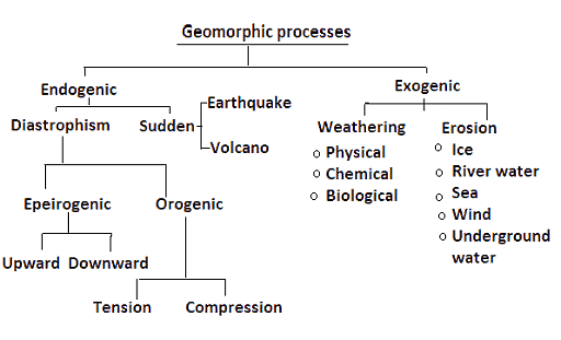
Geomorphic Processes
Slow Movements or Diastrophism
- Diastrophism refers to all processes that move, elevate, or deformation of the earth’s crust due to diastrophic movements (deforming movements) such as folding, faulting, warping (bending or twisting of a large area), and fracturing.
- Diastrophism encompasses all processes that move, elevate, or build-up sections of the earth’s crust.
- Diastrophic changes are slow and can last for thousands of years.
History Behind Slow Movements (Diastrophism)
- By the end of the nineteenth century, it was widely believed that the reason for folding and faults was lateral compression produced by the Earth’s gradual cooling, which resulted in a decreasing Earth.
- Eduard Suess proposed his eustatic hypothesis which formed the foundation for Chamberlin‘s explanation of diastrophism.
- Suess stated his conviction that the rise and fall of sea levels could be mapped over the globe over geologic time.
- Suess proposed that sea levels steadily rose as sediments filled ocean basins and that periodic events of fast ocean-bottom subsidence increased the ocean’s capacity and produced the regressions.
- Diastrophic movement, according to Chamberlin, is generated by gravitational contraction rather than thermal contraction.
- Thermal convection did not supplant the shrinking Earth hypothesis in the United States until the late 1960s.
Classification of Diastrophic or Slow Movements
Diastrophic movements are further classified into epeirogenic movements and orogenic movements.
Orogenic Process
- Orogenic movements/ processes, which include mountain-building through extreme folding and influence long and narrow regions of the earth’s crust, are among them.
- Orogenic or mountain-forming movements act tangentially to the earth’s surface, as in plate tectonics. The Himalayan-Alpine orogeny is the best instance of this case.
- These processes are further classified into Tension and Compression.
- Fissures are caused by tension i.e., when force is acting away from a point in two directions.
- The Sierra Nevada (The USA) mountain range is the best example of a mountain that is formed by tension.
- Folds appear as a result of compression i.e., when force is acting towards a point.
- The Himalayas is the best example of a mountain that is formed by compression.
Epeirogenic Process
- Movements that form continents are known as epeirogenic or continent-forming movements. They are also known as radial movements because they act along the radius of the earth.
- They can move towards (subsidence) or away from (uplift) the center.
- They create land upheavals or depressions with long-wavelength undulations (wavy surface) and little folding.
- The present-day drainage divides between Limpopo and Zambezi rivers in southern Africa is a classic example of this type.
- Subsidence occurs when movement is in a downward direction.
- It is uplifted from the center when it is away. Raised beaches, elevated wave-cut terraces, sea caves, and so on are examples of uplift
Downward Epeirogenic Movements
- Subsidence occurs when movement is in a downward direction.
- Subsidence is evidenced by submerged forests and valleys, as well as structures.
- A section of the Rann of Kachchh was inundated due to an earthquake in 1819.
- Subsidence is evidenced by the presence of peat and lignite beds below sea level in Thirunelveli (Tamil Nadu) and the Sunderbans(West Bengal).
- The submergence of the intervening terrain has cut the Andamans and Nicobars off from the Arakan coast.
- Trees have been discovered embedded in the mud about 4 meters below the low tide line on the east side of Bombay Island. On the Thirunelveli coast in Tamil Nadu, a similar submerged forest has been discovered.
- A substantial portion of the Gulf of Mannar and Palk Strait is quite shallow and was recently submerged.
- The sea has flooded a portion of the former town of Mahabalipuram near Chennai (Madras).
Upward Epeirogenic Movements
- It is uplifted from the center when it is away. Raised beaches, elevated wave-cut terraces, sea caves, and so on are examples of uplift.
- Uplift is evidenced by elevated beaches, elevated wave-cut terraces, sea caves, and fossiliferous deposits above sea level.
- Raised beaches can be seen around the Kathiawar, Nellore, and Thirunelveli coasts, with some rising as high as 15 to 30 meters above the current sea level.
- Several locations that were once on the sea have relocated a few miles inland.
- Coringa near the Godavari’s mouth, Kaveripattinam in the Kaveri delta, and Korkai on the coast of Thirunelveli, for example, were all thriving seaports 1,000 to 2,000 years ago.
Significance of Diastrophism
Formation of Landforms
- Diastrophism is responsible for creating a range of landforms, from mountain ranges to plateaus and basins.
- For instance, the Himalayas, Alps, and Andes have formed as a result of orogenic movements.
- Epeirogenic movements can raise or lower continental blocks, leading to the formation of continental shelves or interior basins.
Influence on Climate
- The formation of mountain ranges can act as barriers to moisture-laden winds, leading to orographic rainfall on the windward side and creating rain shadows on the leeward side.
- Mountain ranges can also influence atmospheric circulation patterns and jet streams.
Biodiversity Hotspots
- Mountain ranges and highlands, often products of diastrophism, can act as isolated ecosystems leading to speciation and high biodiversity.
- For example, the Western Ghats in India, a product of tectonic forces, is one of the world’s biodiversity hotspots.
Influence on Human Settlements
- Regions uplifted due to diastrophism can influence river courses, leading to fertile plains suitable for agriculture and human settlement.
- Conversely, certain areas might become uninhabitable due to extreme elevation or rugged terrain.
Impacts on Ocean Circulation
- The rise or fall of land can influence ocean currents. For instance, the uplift of the Isthmus of Panama separated the Pacific and Atlantic Oceans, altering oceanic circulation and having global climatic implications.
Scientific Understanding
- Studying diastrophism offers insights into the Earth’s internal processes, plate tectonics, and the dynamic nature of the planet’s crust.
- It aids in understanding the Earth’s geological history and predicting future movements or changes.
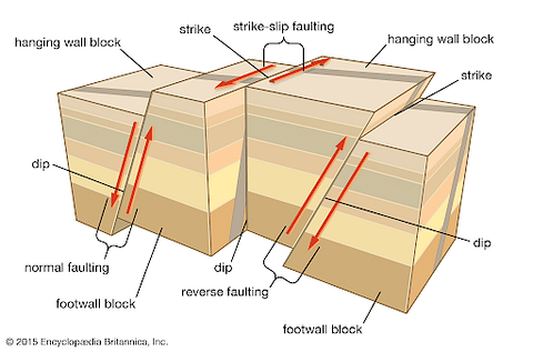
A fault is a fracture or zone of fracture between two blocks of rock. Faulting occurs when a rock above an inclined fracture plane slides over the rock on the opposite side of the fracture as it slides. This movement may occur rapidly, in the form of an earthquake, or may occur slowly, in the form of creep. Faulting may range in length from a few millimeters to thousands of kilometers. Most faults produce repeated displacements over geologic time. During an earthquake, the rock on one side of the fault suddenly slips with respect to the other.
Faulting
- Faulting is a geological process by which rocks fracture and undergo displacement due to tectonic forces.
- It results from the Earth’s lithospheric plates’ movement, leading to stress buildup in the Earth’s crust.
- When the stress surpasses the rock’s strength, it results in a sudden fracture or break, known as a fault.
- The movement along these faults can lead to earthquakes.
- Faults are formed due to the combined effect of both the compressional and tensional forces, but a tensional force plays a significant role in it.
- Exclusive stress and strains produce fracturing and are usually accompanied by dislocation.
- Such relatively rapid movement produced crustal blocks (Horsts) and rift valleys or depressions (Graben).
- Horsts and Graben are found in association with one another.
- The plane along which the rocks are displaced is called the fault plane.
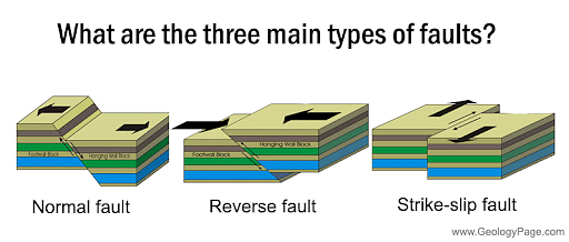
Types of Faults
- Normal Fault: It is caused by extensional forces where the Earth’s crust is being pulled apart. The hanging wall (the block above the fault plane) moves downward relative to the footwall.
- Reserve Fault (Thrust Fault): Resulting from compressional forces where the Earth’s crust is being pushed together. In this case, the hanging wall moves upward relative to the footwall.
- Strike Slip Fault: It is caused by horizontal shearing forces. The blocks on either side of the fault move horizontally past each other with little vertical movement.
- Oblique Fault: It is a combination of vertical and horizontal displacements due to both shearing and compressional or extensional forces.
- Listric Fault: These are curved faults where the fault plane is concave upwards. The fault starts nearly vertically at the surface and becomes more horizontal with depth.
- Blind Fault: These faults do not reach the surface, so their existence is not directly observable at the ground level. They are known primarily through indirect methods, like seismic investigations.
- Transform Fault: A specific type of strike-slip fault that offsets segments of the mid-oceanic ridge. The movement on these faults is horizontal, and they link two segments of a diverging boundary or ridge. An example is the transform fault between the North American and Pacific Plates.
Heat energy transfer generally occurs through one of the three processes: conduction, convection, or radiation. Here, we will focus on convection due to molecules’ movement within fluids (liquids or gasses). So, convection currents are a natural heat transfer process involving energy moving from one place to another.
What are Convection Currents?
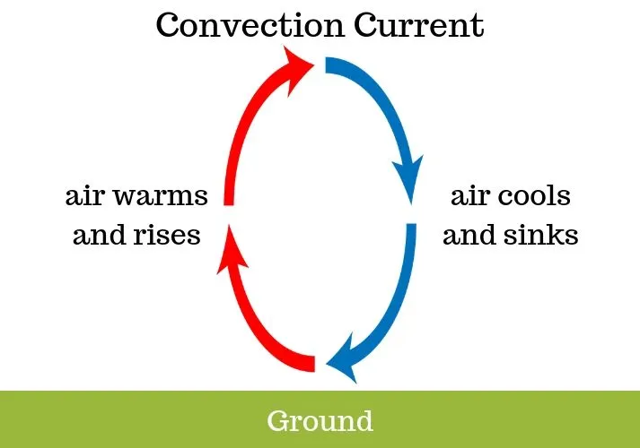
Convection currents are the transfer of heat within a fluid or gas caused by differences in temperature and density, creating a circular flow.
The difference in densities of the fluid occurring due to temperature gradients gives rise to the convection currents. Convection results in heat transfer by the difference in temperature between the two parts of the liquid. Due to this, hot fluids tend to rise, and the cold fluids tend to sink, resulting in a current within the fluid called the convection current.
A natural convection current results from the continuous replacement of the heated fluid by the nearby present cooler fluid. The resulting heat and the mass transfer, enhanced due to this natural convection current, are termed natural convection heat and mass transfer.
Theory of Convection Currents
The process in which heat transfer takes place between a surface and a fluid that is in contact with each other is called convection heat transfer.
In convection, heat transfer takes place through diffusion or advection (the transport of a substance by bulk motion of fluid) or sometimes both. This phenomenon is not observed in solids, as no movement of its constituent particles is seen. The diffusion of heat occurring in solids is known as thermal conduction.
Thermal expansion takes place when we heat a fluid from below. As a result, the lower layers of the fluid, which are hotter due to heat, become less dense. Then, due to buoyancy, the less dense (or the hotter) part of the fluid rises up and the denser (or the colder) fluid replaces it and settles down. When this part also gets heated, it rises up and is replaced by the colder upper layer. In this manner, this process is repeated continuously and as a result, the whole amount of fluid gets heated. This is how the heat is transferred through the process of convection.
What Causes Convection Currents?
Convection currents arise due to the uneven heating of a fluid. When the fluid is heated, its density decreases, prompting it to ascend. This density change results from the increased speed and separation of fluid molecules. As these molecules spread apart, the fluid’s density diminishes, leading to its upward movement. This cycle of convection persists until the entire fluid within the system reaches a uniform temperature.
Effect of Convection on Earth’s Climate
The convection process in the earth’s mantle’s deep surface impacts the Earth’s climate. Molten rocks are present deep inside the Earth’s surface that circulate through convection currents. They are in a semi-liquid state, so they start rising after becoming hot and less dense. And finally, they transfer the heat to the Earth’s crust, becoming less dense and sinking back to the Earth’s core. This process is responsible for heating the Earth’s surface.
Convection influences the atmosphere through the movements of the Ocean and Continental plates. The atmosphere circulates a massive amount of air resulting in the change of the position of the basins and continents in the ocean, just like how the weather and air movements change all over the globe. Furthermore, it is supposed that the convection in the earth’s mantle plays a vital role in creating Earth’s magnetic field due to the flow of liquid iron through the mantle.
Examples of Convection Currents
Let us discuss a few examples of a convection current.
- Campfires: The convection currents heat our hands. That’s why we feel hot around the campfire.
- Convection currents are present in the air: A typical example of a convection current is the warm air that rises towards the ceiling of a house since the warm air is less dense than the cold air.
- Boiling of Water: When boiling water on the stove, the temperature of water molecules starts increasing, and they slowly begin to move rapidly. As the hotter molecules rise above, they become less dense and rise above. This movement occurs within this boiling water, making up for the convection currents.
- Changes in the weather: The breeze near a beach is the effect of convection currents which is also responsible for daily weather changes.
Rejuvenation in geography refers to the process by which a river or landscape regains its capacity to erode down to a lower base level, often due to a change in conditions. This phenomenon typically occurs when there is a fall in sea level, uplift of land, or a change in the course of the river, leading to an increase in the river’s erosional power. The rejuvenated river gains energy and starts cutting vertically into its valley, resulting in the formation of distinct landforms and features.
Key features of rejuvenation include river terraces, incised meanders, and knick points. River terraces are remnants of previous valley floors left elevated as the river cuts down into its bed. Incised meanders are deeply entrenched bends in the river, created when a rejuvenated river cuts into its older meanders. A knick point marks a sudden change in the river’s gradient, often appearing as a waterfall or rapid, signifying the onset of rejuvenation.
Rejuvenation plays a crucial role in shaping landscapes over time, as it modifies valleys and contributes to the diversity of geomorphic features. It often disrupts the equilibrium of the river, causing renewed erosion in the upper course and deposition in the lower course. Human activities such as dam construction or climate change can also trigger rejuvenation by altering base levels or water flow.
In summary, rejuvenation is a dynamic process that revitalizes a river’s erosional capacity, leading to significant changes in the topography and formation of distinctive geographical features. Its study provides insights into the interplay of natural forces that shape the Earth’s surface.
A periglacial region refers to areas located near or on the margins of glacial environments, typically characterized by intense frost action and processes related to the freezing and thawing of the ground. These regions are commonly found in high-latitude or high-altitude areas that are not permanently covered by ice but experience severe cold climates. The defining feature of periglacial environments is the presence of permafrost, which is ground that remains frozen for at least two consecutive years.
In periglacial regions, the active layer above the permafrost thaws seasonally, resulting in unique geomorphological processes. Key phenomena include frost heaving, where soil and rocks are displaced due to freezing water, and solifluction, the slow, downslope movement of water-saturated soil during thaw periods. Another characteristic feature is patterned ground, which includes formations such as stone circles, polygons, and stripes created by the repetitive freezing and thawing cycle.
Periglacial regions have significant ecological and hydrological importance. They store large amounts of carbon in frozen soils, which may be released into the atmosphere as methane or carbon dioxide if the permafrost melts due to climate change. Human activities, such as infrastructure development in these regions, face challenges due to ground instability caused by permafrost thawing.
Examples of periglacial regions include parts of Siberia, Alaska, and northern Canada, as well as areas in Greenland and the Himalayas. These regions are crucial for studying the impacts of climate change, as they are highly sensitive to temperature fluctuations, making them important indicators of global environmental shifts.
A hurricane is a powerful tropical storm characterized by strong winds, heavy rainfall, and low pressure systems, forming over warm ocean waters in the Atlantic Ocean or the eastern Pacific Ocean. Known as typhoons in the western Pacific and cyclones in the Indian Ocean, hurricanes are part of the broader category of tropical cyclones. These systems are fueled by the release of latent heat from warm, moist air rising over oceans with surface temperatures exceeding 26°C (79°F).
Hurricanes develop in several stages: tropical disturbance, tropical depression, tropical storm, and finally, a hurricane once wind speeds reach or exceed 74 miles per hour (119 km/h). The structure of a hurricane includes the eye, a calm, low-pressure center; the eyewall, where the most intense winds and rainfall occur; and rainbands, spiral arms of heavy precipitation extending outward.
These storms are categorized on the Saffir-Simpson Hurricane Wind Scale, ranging from Category 1 (least severe) to Category 5 (most severe), based on sustained wind speeds. Hurricanes pose significant threats, including storm surges, flooding, high winds, and tornadoes, often causing extensive damage to infrastructure, ecosystems, and human lives.
Hurricanes are influenced by factors such as Coriolis force, which gives them their characteristic rotation, and global wind patterns, which determine their trajectory. They typically lose energy upon making landfall or moving over cooler waters.
Efforts to mitigate hurricane impacts include advanced forecasting, early warning systems, and preparedness measures like evacuation plans. As climate change increases sea surface temperatures, hurricanes may become more frequent and intense, underscoring the need for enhanced disaster management and resilient infrastructure.
El Niño is a climate phenomenon characterized by the unusual warming of sea surface temperatures in the central and eastern equatorial Pacific Ocean. It disrupts normal atmospheric and oceanic circulation patterns, causing significant impacts on global weather systems. El Niño events typically occur every 2 to 7 years and can last for several months to over a year.
The phenomenon is part of the El Niño-Southern Oscillation (ENSO) cycle, which includes El Niño (warm phase), La Niña (cool phase), and a neutral phase. During El Niño, weakened trade winds reduce the upwelling of cold, nutrient-rich waters along the South American coast, leading to warmer ocean temperatures. This disrupts marine ecosystems, affecting fisheries and local economies, particularly in countries like Peru and Ecuador.
El Niño has widespread impacts on global weather patterns. It often brings droughts to regions such as Australia, Indonesia, and southern Africa, while causing heavy rainfall and flooding in parts of South America and the southern United States. These changes can lead to crop failures, water shortages, and increased risks of wildfires or landslides, affecting millions of people.
The phenomenon also influences hurricane activity. While it tends to suppress hurricanes in the Atlantic Ocean, it often enhances their formation in the eastern Pacific. Scientists monitor El Niño using satellite data, ocean buoys, and climate models to predict its onset and impacts, aiding in disaster preparedness.
Understanding El Niño is crucial for managing its social, economic, and environmental consequences. As climate change progresses, the frequency and intensity of El Niño events may increase, necessitating global efforts to mitigate and adapt to its effects.
In geography, a geyser is a natural hot spring that intermittently ejects a column of hot water and steam into the air. Geysers are rare phenomena, found in areas with active volcanism, where heat from magma interacts with underground water. The word “geyser” originates from the Icelandic term “Geysir”, derived from a hot spring in Iceland.
Geysers form in regions with a unique combination of heat, water, and plumbing systems. Magma beneath the Earth’s surface provides the heat, while groundwater seeps into underground chambers. The plumbing system, composed of fractures and porous rocks, traps the water. As the water heats up, it becomes superheated under pressure. When the pressure is released, often due to boiling, water is ejected forcefully, producing the iconic eruption.
Geysers are often found in geothermal areas, such as Yellowstone National Park in the United States, Iceland, New Zealand, and parts of Russia. Yellowstone is home to famous geysers like Old Faithful, known for its regular eruptions.
Geysers contribute to the geomorphological landscape and are significant for tourism and scientific research. They provide insights into Earth’s geothermal systems and help monitor volcanic activity. However, geysers are sensitive to changes in their environment. Overextraction of groundwater or geological disturbances can disrupt their activity, causing them to become dormant.
In summary, geysers are fascinating features of geothermal regions, showcasing the dynamic interaction of heat, water, and Earth’s internal processes. Their study enhances our understanding of volcanic and geothermal systems and underscores the importance of preserving these natural wonders.
Sea floor spreading is a geological process that explains the formation and expansion of the oceanic crust. It occurs at divergent plate boundaries, particularly along mid-ocean ridges, where tectonic plates move apart. This process is a key mechanism in the theory of plate tectonics and contributes to the dynamic nature of Earth’s lithosphere.
At mid-ocean ridges, magma from the Earth’s mantle rises to the surface through cracks created by the diverging plates. The magma cools and solidifies upon contact with seawater, forming new oceanic crust. As more magma rises and solidifies, the newly formed crust pushes older crust outward, causing the sea floor to spread. This continuous process creates a symmetrical pattern of oceanic crust on either side of the ridge.
Magnetic anomalies in the ocean floor provide evidence for sea floor spreading. As magma cools, iron-rich minerals within it align with Earth’s magnetic field. Since the Earth’s magnetic field has reversed many times throughout history, these magnetic patterns are recorded in the oceanic crust as bands of alternating polarity. This symmetrical magnetic striping on both sides of the mid-ocean ridge supports the concept of sea floor spreading.
Sea floor spreading plays a crucial role in the recycling of crust through the process of subduction, where older oceanic crust is pushed beneath continental plates at convergent boundaries and reabsorbed into the mantle. This dynamic process contributes to the creation of new crust, the movement of continents, and the formation of geological features like trenches and volcanic arcs.
A kratogen is a stable and rigid section of the Earth’s crust that has remained largely unaffected by tectonic activity for extended geological periods. It represents the core of continental shields or cratons, which are the oldest and most stable parts of the Earth’s lithosphere. The term “kratogen” is often used interchangeably with craton, though some geologists distinguish it as a more precise reference to regions that have not undergone significant deformation or metamorphism.
Kratogens are typically composed of ancient igneous and metamorphic rocks, often dating back to the Precambrian era, over 540 million years ago. These regions serve as the foundational blocks of continents, surrounded by younger and more tectonically active regions, such as orogenic belts. Examples include the Canadian Shield in North America, the Baltic Shield in Europe, and the Indian Shield in Asia.
Despite their stability, kratogens can experience minor geological processes, such as weathering, erosion, and sediment deposition. However, they are generally resistant to folding, faulting, and volcanic activity. Their stability is attributed to their location far from active plate boundaries, as well as the thickness and density of their lithosphere.
Kratogens are significant in understanding Earth’s geological history. They preserve evidence of ancient tectonic processes, mineral deposits, and the evolution of the planet’s crust. These regions are also economically important, as they often host rich reserves of minerals such as gold, diamonds, and iron ore.
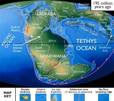
Tethys Sea
- The Tethys Ocean also called the Tethys Sea or the Neo-Tethys, was an ocean during much of the Mesozoic Era and early Cenozoic Era.
- It was located between the ancient continents of Gondwana and Laurasia, before the opening of the Indian and Atlantic oceans during the Cretaceous Period.
- It was preceded by the Paleotethys Ocean, which lasted between the Cambrian and the Early Triassic, while the Neotethys formed during the Late Triassic and lasted until the early Eocene (about 50 million years ago) when it completely closed.
- A portion known as the Paratethys formed during the Late Jurassic, was isolated during the Oligocene (34 million years ago) and lasted up to the Pliocene (about 5 million years ago), when it largely dried out.
- Many major seas and lakes of Europe and Western Asia, including the Mediterranean Sea, the Black Sea, the Caspian Sea, the Aral Sea, and Lake Urmia, are thought to be remnants of the Paratethys.
Walther Penck, a prominent German geomorphologist, proposed an alternative model of landform development known as the morphological system, challenging the time-dependent Davisian model of geographical cycle. Penck’s approach emphasized the relationship between tectonic activity (endogenetic processes) and erosion (exogenetic processes) in shaping landscapes, rejecting the cyclic concept of youth, maturity, and old age.
Penck introduced the concept of primarumpf, representing the initial landscape before upliftment. This surface could be a newly exposed landmass or a peneplain-like feature at low altitudes, serving as the starting point for landform evolution. According to Penck, the landscape’s development reflects the interaction between rates of uplift and rates of degradation rather than a sequential stage process.
He identified three phases of landscape evolution:
Aufsteigende Entwickelung (Waxing Development): This phase involves an accelerating rate of uplift. Rivers deepen their valleys rapidly, forming steep, V-shaped profiles, but uplift exceeds erosion, increasing both absolute height and relief.
Gleichformige Entwickelung (Uniform Development): During this phase, uplift and erosion rates reach equilibrium. Absolute height stabilizes or increases marginally, while relative relief remains constant. Subphases reflect transitions between uplift dominance and uniform degradation.
Absteigende Entwickelung (Waning Development): Uplift ceases, and erosion dominates, leading to reduced absolute and relative relief. This phase ends with the formation of endrumpf, a low-relief surface akin to Davis’ peneplain.
Penck’s model has been criticized for its obscure terminology, incomplete articulation, and misinterpretation by reviewers like W.M. Davis. However, his insights into slope development, parallel retreat, and long-term tectonic activity hold significant geomorphological value, even if his broader framework was less widely adopted.
Davis had divided the evolution of landforms into three distinct stages: 1. Youthful Stage 2. Mature Stage 3. Old Stage.
1. Youthful Stage
By this time, if rainfall occurs, the rain water will start flowing along the natural slope towards the sea in the form of alls, gullies, streams and ultimately rivers.

As a consequence, erosion is in. This is the youthful stage of the Davis’ cycle.
At this stage:
- The vertical erosion of the streams is most significant,
- The streams follow the natural slope,
- The river valleys are deep and steep-sided,
- Mountain summits are high and rugged,
- Streams divides are broad and irregular.
As the process of erosion continues, towards the end of the youthful stage, the depth of the river goes on decreasing and erosion increases towards the top of the mountain. At this stage, the river gets affected by the structure of the rock.
The river cannot vertically cut the land below the sea level. Over the land, the level (assumed to be extension of sea level) below which the river cannot perform any vertical erosion is called base level. For the water of the river to keep running, it is necessary that the river has to remain above the base level.
However, continued erosion brings the rivers to such a stage where erosional activities stop completely and the sediments are carried away along with the flow of water. This stage of the river is known as graded stage.
2. Mature Stage
Through continued erosional activities of the river, the land surface begins to be levelled down. As soon as the lowering of the relief of the uplifted area starts, the landform is said to have attained mature stage.
Maturity is marked by:
- Wide river valleys
- River capture, meandering, ox-bow lakes and formation of flood-plains
- Horizontal erosion becomes more dominant and intensity of vertical erosion decreases
- The rivers get closer to graded condition
- The whole area is covered with sediments
- The mountain slopes become very gentle
- Stream divides get smaller and gentler.

3. Old Stage
At this stage, the rivers flow in a zig-zag way through their floodplains. The landform attains such a low relief and gentle slope that it becomes almost an undulating plain known as peneplain. The whole area is covered with tremendous amount of sediments and the slope of the area becomes very gentle.
However, the hard and resistant rocks in the water-divides are seen to have scattered over the area. These eroded and low relics of landforms are called Monadnocks.

The old stage is marked by:
- Gentle undulating plain
- Very low inter-stream divides
- Meandering courses of river
- Thick layers of sediments and erosional remnants scattered over the water-divides.
After attaining the old stage, the area over which the rivers flow may be raised again by the endogenetic forces. It is known as rejuvenation of the landform.
Scattering is the phenomenon where light or other electromagnetic waves deviate from their straight path when interacting with particles, atoms, or molecules in a medium. This process is a key concept in understanding how light behaves in different environments, particularly in gases, liquids, and solids. The degree and type of scattering depend on the size of the particles, the wavelength of light, and the nature of the medium.
One of the most notable types of scattering is Rayleigh scattering, which occurs when the particles causing the scattering are much smaller than the wavelength of light. This is responsible for the blue color of the sky, as shorter wavelengths like blue are scattered more than longer wavelengths such as red. Another significant type is Mie scattering, which happens when the particle size is comparable to or larger than the wavelength. This type is often observed in clouds and fog, where the scattering is independent of wavelength, leading to a whitish appearance.
Scattering is also crucial in various applications, such as in remote sensing, medical imaging, and telecommunications. In astronomy, the study of scattering helps in analyzing the composition of atmospheres on distant planets. Moreover, understanding scattering mechanisms is vital for explaining phenomena like the reddish hues of sunsets and sunrises and the whitish appearance of mist and clouds.
By studying scattering, scientists can infer valuable information about the properties of materials and particles, making it an essential concept in fields like physics, atmospheric science, and engineering.
The wet adiabatic rate of cooling refers to the rate at which a rising saturated air parcel cools as it ascends in the atmosphere. This process is fundamental in understanding atmospheric dynamics and weather formation. Unlike the dry adiabatic lapse rate, which applies to unsaturated air, the wet adiabatic rate is lower because latent heat is released during condensation.
When air rises, it expands due to decreasing atmospheric pressure, causing it to cool. If the air becomes saturated (i.e., it reaches its dew point temperature), condensation occurs, forming clouds. During condensation, the latent heat of vaporization is released into the air parcel, offsetting some of the cooling caused by expansion. This release of latent heat reduces the cooling rate, making it slower than the dry adiabatic lapse rate, which is approximately 10°C per kilometer.
The wet adiabatic rate varies between 4°C and 9°C per kilometer, depending on factors like the amount of moisture in the air and the ambient temperature. Warm, moist air releases more latent heat during condensation, leading to a slower cooling rate, whereas cooler or drier air releases less latent heat and cools more rapidly.
Understanding the wet adiabatic cooling process is essential for explaining the formation of clouds, precipitation, and thunderstorms. It also helps in studying phenomena like orographic lifting and convective storms, where rising air plays a critical role. This concept is vital for meteorology, aviation, and climate studies, as it directly influences weather patterns and temperature distribution in the atmosphere.
Gondwana Land was a massive supercontinent that existed during the Late Paleozoic and Mesozoic eras, comprising what are now the southern continents. Named after the Gondwana region of India, this landmass included South America, Africa, Antarctica, Australia, the Indian subcontinent, and the Arabian Peninsula. It was part of the larger supercontinent Pangaea, which began to break apart approximately 200 million years ago during the Jurassic Period.
The formation of Gondwana Land was significant in Earth’s geological history as it shaped the climate, biodiversity, and topography of the modern continents. Its breakup was driven by plate tectonic movements, which caused the drifting and reorganization of the continents to their present positions. This tectonic activity led to the formation of major geological features, such as the Himalayas, as the Indian plate collided with the Eurasian plate.
Gondwana Land played a crucial role in the evolution of life, as it provided a unique environment for the development of early plants, animals, and ecosystems. Fossil evidence, including the remains of Glossopteris flora and other ancient species, confirms the shared biological history of these continents. This fossil evidence was also instrumental in supporting Alfred Wegener’s theory of continental drift.
The legacy of Gondwana Land is evident in the similarities of rock formations, fossil records, and natural resources across its former parts. Its geological processes have left behind rich coal, oil, and mineral reserves, which are vital for the economies of many countries today. Understanding Gondwana Land offers insights into the Earth’s past and helps geologists predict future tectonic movements and their implications.
Pangea was a supercontinent that existed during the Late Paleozoic and Early Mesozoic eras, approximately 335 to 175 million years ago. It was formed by the gradual collision of smaller landmasses and covered nearly one-third of Earth’s surface, surrounded by a vast ocean called Panthalassa. The name “Pangea,” meaning “all Earth” in Greek, reflects the fact that it brought together almost all the landmasses of the world into one contiguous entity.
The formation of Pangea was a result of tectonic plate movements caused by the Earth’s dynamic mantle processes. Its existence marked a significant phase in Earth’s geological and biological history. Pangea’s climate varied, with arid deserts in the interior regions and lush, tropical conditions near the coasts, which supported diverse ecosystems.
Around 175 million years ago, Pangea began to break apart due to the processes of continental drift and plate tectonics. This breakup gave rise to the northern supercontinent Laurasia and the southern supercontinent Gondwana, eventually leading to the formation of the modern continents. The Atlantic Ocean formed as the continents drifted apart.
Pangea’s existence profoundly influenced the evolution of life. The unification of landmasses allowed for the widespread distribution of species, but its breakup triggered geographic isolation, leading to evolutionary divergence. Fossil evidence, such as that of the Mesosaurus and Glossopteris flora, supports the idea of a connected landmass, serving as key evidence for Alfred Wegener’s theory of continental drift.
Understanding Pangea provides valuable insights into Earth’s geological processes, past climates, and the movement of tectonic plates, helping scientists predict future continental shifts and their implications for life and the environment.
Mid Oceanic Ridges
Plate tectonics formed an underwater mountain range known as a Mid-Oceanic Ridge. It is made up of two mountain chains separated by a large depression. Mountain Ranges can have peaks as high as 2,500 metres, and some even rise above the ocean’s surface.
Underwater expeditions have been conducted to study the ocean floor, revealing unique and spectacular features. Tsunamis are often caused by underwater earthquakes, which occur along plate boundaries where the Earth’s tectonic processes take place. Modern maps of the ocean floor have improved our understanding of these underwater features and the earth’s tectonic activities. The ocean’s characteristics vary based on location, origin, shape, type of rock, and water movement.
Mid Ocean Ridges Formation
The Mid Ocean Ridges are one of the most distinctive structures among them. The Mid Ocean Ridges, as the name suggests, are mostly found in the middle of ocean basins, where divergent plate boundaries exist. Many major tectonic processes have been identified by Plate Tectonics Theory, including the release of convection currents along Divergent Plate Boundaries, the origin of Mid Ocean ridges, and the spreading of the sea floor. All of these processes are ongoing phenomena on the planet.
Mid-Indian Ridge
The Mid-Indian Ridge is a submarine ridge in the Indian Ocean connected to the Mid-Atlantic Ridge as part of the global mid-ocean ridge system. It starts in the South Atlantic and extends north to near Rodrigues Island, where it splits into two branches:
- one goes north toward the Gulf of Aden, linking with the East African Rift System, and
- the other heads southeast toward the Macquarie Islands.
The Carlsberg Ridge is a section of the Mid-Indian Ridge located between the Gulf of Aden and Rodrigues Island. This ridge is seismically active because it is linked to a zone of earthquake epicenters.
Mid-Oceanic Ridges Types
Mid-ocean ridges vary in shape, also known as “morphology,” depending on how quickly they spread, how active they are magmatically and volcanically, and how much tectonic stretching and faulting occurs.
1. Fast-Spreading Mid-Ocean Ridge
Ridges like the northern and southern East Pacific Rise spread quickly and are “hotter,” meaning there is more magma below them, which leads to more volcanic eruptions. Scientists believe that because the plate beneath the ridge crest is hotter, it responds to the divergent spreading process more fluidly. To put it simply, the ridge spreads more like hot taffy being pulled apart.
2. Slow-Spreading Mid-Ocean Ridge
At slower-spreading ridges like the northern Mid-Atlantic Ridge, the seafloor behaves like nougat or cold chocolate bars when pulled apart. As it stretches, the ocean crust breaks into ridges and valleys.
Mid Ocean Ridges Principal Characteristics
At the crests of oceanic ridges, new oceanic crust and part of the Earth’s upper mantle are formed, creating distinct geological features. Fresh basaltic lavas are exposed on the seafloor, which are eventually covered by sediments as the seafloor spreads. The heat flow from the crust at these ridges is much higher than elsewhere on Earth, and earthquakes are common along the ridges and transform faults, indicating tension in the oceanic crust.
The depth over oceanic ridges is closely linked to the age of the crust; as the crust gets older, it sinks deeper. This sinking is due to thermal contraction as the crust moves away from the spreading center. The width of a ridge is defined by how far the crust has cooled down, which typically takes about 70 to 80 million years, by which time ocean depths reach about 5 to 5.5 km (3.1 to 3.5 miles).
Slow-spreading ridges like the Mid-Atlantic Ridge are narrower than faster-spreading ones like the East Pacific Rise because of this cooling process. There is also a connection between global spreading rates and changes in ocean water levels on continents.
Mid-Oceanic Ridges Major Distribution
Oceanic spreading centres can be found in every ocean basin. A slow-rate spreading centre in the Eurasian basin is located near the eastern side of the Arctic Ocean. It can be followed south to Iceland, offset by transform faults. Iceland was formed by a hot spot directly beneath an oceanic spreading centre. The Reykjanes Ridge, which leads south from Iceland, lacks a rift valley despite spreading at 20 mm (0.8 inches) per year or less. This is thought to be due to the hot spot’s influence.
Atlantic Ocean
- The Mid-Atlantic Ridge stretches from Iceland to the extreme South Atlantic Ocean near 60° S latitude.
- It was previously known as a mid-ocean ridge since it runs through the Atlantic Ocean basin.
- In the 19th century, knowledge of the Mid-Atlantic Ridge was limited.
- In 1855, the U.S. Navy’s Matthew Fontaine Maury created a chart identifying it as a shallow “middle ground.”
- In the 1950s, American oceanographers Bruce Heezen and Maurice Ewing suggested it was a continuous mountain range.
- The crest of the ridge has an axial high at fast spreading rates.
- The flanks of slow-spreading ridges have rough, faulted topography, while the flanks of faster-spreading ridges are smoother.
Indian Ocean
- The Southwest Indian Ridge is a very slow oceanic ridge located between Africa and Antarctica.
- It connects the Mid-Indian Ridge and the Southeast Indian Ridge east of Madagascar.
- The Carlsberg Ridge is at the northern end of the Mid-Indian Ridge, moving north to join spreading centers in the Gulf of Aden and the Red Sea.
- Spreading is very slow in this area, but on the Carlsberg and Mid-Indian ridges, it approaches intermediate rates.
- The Southeast Indian Ridge spreads at a medium rate, extending southeast from the western Indian Ocean between Australia and Antarctica.
- The Southwest Indian Ridge has rifted crests and rugged, mountainous flanks.
- The Mid-Indian Ridge has fewer of these features, while the Southeast Indian Ridge has smoother topography.
- The Southeast Indian Ridge also shows asymmetric seafloor spreading south of Australia.
- Magnetic anomalies indicate that spreading rates on opposite sides of the center have been unequal over the last 50 to 60 million years.
Pacific Ocean
- The Pacific-Antarctic Ridge stretches northeast from halfway between New Zealand and Antarctica to meet the East Pacific Rise off the coast of South America.
- It spreads at intermediate to fast rates.
- The East Pacific Rise extends north to the Gulf of California and connects with the Pacific-North American plate boundary.
- Currently, the East Pacific Rise spreads offshore from Chile and Peru at rates of over 159 mm (6.3 inches) per year, dropping to about 60 mm (2.4 inches) per year at the Gulf of California.
- The ridge’s crest has a low topographic rise instead of a rift valley.
- Discovered during the 1870s Challenger Expedition, the East Pacific Rise was described more fully by oceanographers in the 1950s and 1960s.
- In the 1980s, scientists found that the main spreading center is often interrupted and offset, creating overlapping spreading centers due to interruptions in the magma supply.
- Smaller spreading centers branch off from larger ones and can be found in various locations, including the Fiji Plateau, Woodlark Basin, Scotia Sea, and near the Galapagos Islands.
Zwischengebirge is a German term that translates to “intermediate mountains” or “in-between mountains.” It refers to mountain ranges or elevated terrains located between two larger or more prominent geological features, such as higher mountain ranges or extensive plateaus. These formations often serve as transition zones, bridging different geographical or geological regions.
Zwischengebirge are typically characterized by moderate elevation, smaller peaks, and relatively gentle slopes compared to towering high-altitude ranges like the Himalayas or the Alps. Their geological structure often results from processes like erosion, folding, or faulting, which shape the terrain over millions of years. These areas may also be influenced by glacial activity, river valleys, and tectonic forces, depending on their location.
Ecologically, Zwischengebirge often support diverse flora and fauna, serving as important habitats for species that thrive in temperate or transitional environments. These regions can also act as corridors for migration, enabling the movement of wildlife between ecosystems. Additionally, Zwischengebirge are significant for human settlements, agriculture, and forestry, given their moderate climate and fertile valleys.
In Europe, examples of Zwischengebirge include regions within the Central Uplands of Germany, like the Harz Mountains or the Thuringian Forest, which lie between higher ranges such as the Alps to the south and the North German Plain to the north. These areas hold historical and cultural importance, often being centers for traditional industries like mining and woodcraft.
Understanding Zwischengebirge provides insights into regional geography, geology, and ecology, highlighting their role in shaping landscapes, supporting biodiversity, and influencing human activities.
A Karst Window is a geological feature commonly found in karst landscapes, which are areas characterized by soluble rock formations like limestone, gypsum, or dolomite. These landscapes are shaped by the processes of chemical weathering and erosion caused by water. A karst window forms when a section of a subterranean river or cave system becomes exposed at the surface due to the collapse of the overlying rock or soil layers.
Karst windows provide a view into the otherwise hidden underground drainage systems of karst regions. They often appear as sinkholes, natural bridges, or depressions where a previously enclosed waterway or cavern is now open to the surface. These features are significant for understanding the hydrology and geomorphology of karst terrains, as they reveal the movement of water through subsurface channels.
These windows are vital for ecological and environmental studies, as they often support unique aquatic ecosystems adapted to the interplay between surface and underground environments. They also play a role in the recharge of aquifers, as water infiltrates through them into the groundwater system.
Examples of karst windows can be found in prominent karst regions like the Mammoth Cave System in the United States or the Dinaric Alps in Europe. They are significant for scientific research, tourism, and water resource management. However, these features are also vulnerable to pollution and human activities, which can disrupt their delicate ecosystems and the quality of groundwater.
A monadnock, also known as an inselberg, is an isolated hill or mountain that rises abruptly from a relatively flat surrounding plain. It is typically composed of hard, resistant rock, such as granite or quartzite, that withstands the forces of erosion better than the softer rock layers around it. Over time, the surrounding terrain is worn down by weathering and erosion, leaving the monadnock standing prominently as a geological feature.
Monadnocks form through a variety of processes, often starting with tectonic uplift or volcanic activity that exposes the harder rock layers. As erosion progresses, the softer rocks are stripped away, while the harder rock remains intact due to its resistance to weathering. These formations are commonly found in regions where differential erosion plays a significant role in shaping the landscape.
One famous example of a monadnock is Mount Monadnock in New Hampshire, USA, from which the term derives. Other notable examples include Uluru (Ayers Rock) in Australia and Sugarloaf Mountain in Brazil. These features often serve as landmarks and hold cultural, historical, or spiritual significance for local communities.
Monadnocks are ecologically important as they often create unique microhabitats. Their rocky surfaces may support specialized plant and animal species, making them significant for biodiversity. Additionally, they attract hikers, climbers, and tourists, contributing to local economies.
Studying monadnocks provides insights into geological processes, such as erosion, weathering, and tectonic activity. They also offer clues about the geological history of a region, revealing how landscapes have evolved over millions of years.
Uvala and Polje are both karstic landforms found in regions shaped by dissolution of soluble rocks such as limestone, gypsum, or dolomite. These features are created through complex processes of erosion, weathering, and chemical dissolution of bedrock, which are characteristic of karst landscapes.
An uvala is a large, closed depression or valley formed by the merging of several smaller sinkholes or doline. The term “uvala” comes from the Slavic word for “hollow,” reflecting its basin-like shape. These depressions typically have a gentle slope and are often surrounded by steep rocky cliffs. Uvalas can be found in regions with extensive karst formations, where erosion processes have combined smaller depressions into a larger, more prominent feature.
A polje, on the other hand, is a much larger, flat-bottomed karst valley. It is typically a wide, open plain that has been formed by the collapse of underground caves and extensive dissolution processes over time. Poljes are often found in regions where the water table is high and where underground rivers flow through the area, creating vast, waterlogged plains. These features are usually fertile and can support agricultural activities due to the alluvial deposits left behind by floodwaters.
Both uvalas and poljes are important in the study of karst topography because they reveal the complex interactions between surface water, underground drainage, and geological processes. In addition to their geological significance, they are also valuable ecologically and economically, often supporting rich biodiversity and human settlements. Examples of uvalas and poljes can be found in places like the Dinaric Alps in Europe and parts of China.
The adiabatic rate of cooling refers to the rate at which an air parcel’s temperature changes as it rises or descends in the atmosphere without exchanging heat with its surroundings. This process is crucial in understanding atmospheric dynamics, particularly in weather formation and cloud development.
When an air parcel rises, it expands due to decreasing atmospheric pressure at higher altitudes, leading to adiabatic cooling. Conversely, when it descends, it compresses under increasing pressure, resulting in adiabatic heating. The cooling or heating depends on whether the air is dry or saturated, leading to two distinct rates: the dry adiabatic lapse rate (DALR) and the wet adiabatic lapse rate (WALR).
The dry adiabatic lapse rate is the cooling rate of unsaturated air, approximately 10°C per kilometer. In contrast, the wet adiabatic lapse rate applies to saturated air and is slower, ranging from 4°C to 9°C per kilometer, depending on the amount of moisture in the air. This difference occurs because, in saturated air, latent heat is released during condensation, partially offsetting the cooling effect.
The adiabatic rate of cooling is critical for phenomena like cloud formation, precipitation, and storm development. For instance, rising air cools and may reach its dew point, causing water vapor to condense into droplets and form clouds. It also explains temperature variations in processes like orographic lifting, where air is forced to rise over mountains, and convective currents, which drive thunderstorms.
Understanding adiabatic cooling rates is vital for meteorology and climate science, as it helps predict weather patterns, assess atmospheric stability, and analyze temperature changes in various altitudinal zones.
Constructive plate margins, also known as divergent boundaries, are areas where tectonic plates move apart from each other. These boundaries are typically found along mid-ocean ridges or within continental rift zones and are characterized by the creation of new crustal material. The process is driven by mantle convection, where rising magma pushes the plates apart, forming new crust as it cools and solidifies.
One of the most prominent examples of a constructive plate margin is the Mid-Atlantic Ridge, where the Eurasian Plate and the North American Plate are moving away from each other. Similar processes occur in the East African Rift, where the African Plate is splitting to form new ocean basins. These margins are responsible for seafloor spreading, a critical component of plate tectonics.
Constructive plate margins often lead to the formation of volcanoes and rift valleys. As the plates diverge, magma from the mantle rises to fill the gap, creating volcanic activity. Over time, this can build underwater mountain ranges or islands. Earthquakes are also common along these margins, but they are typically less intense compared to destructive boundaries.
The geological processes at constructive plate margins contribute to the renewal and recycling of the Earth’s crust. They play a crucial role in heat transfer from the Earth’s interior, influencing the planet’s topography, ocean circulation, and climate patterns. Understanding these margins helps geologists predict volcanic activity and study the dynamic processes shaping the Earth’s surface over geological timescales.
A geosyncline is a large, elongated, and relatively depressed area of the Earth’s crust, typically found in the early stages of the formation of mountain ranges. It is a region where sediments accumulate over long periods, often reaching great thicknesses, and is typically characterized by downwarping or subsidence of the crust. Geosynclines are integral to the theory of plate tectonics and the formation of orogenic belts or mountain ranges.
The accumulation of sedimentary layers in a geosyncline occurs due to the downward movement of the Earth’s crust in response to tectonic forces. These areas are often associated with shallow seas or basins where sediments like sandstone, shale, and limestone accumulate over millions of years. The sediments deposited in the geosyncline are eventually subjected to tectonic compression, which causes the uplift and folding of the accumulated layers, leading to the formation of mountain ranges. This process is part of the broader orogenic process of mountain building.
A classic example of a geosyncline is the Himalayan Geosyncline, which was the precursor to the Himalayan Mountain Range. Other examples include the Appalachian Geosyncline in North America and the Tethys Geosyncline in Europe and Asia.
Geosynclines were once thought to be the primary sites of mountain formation, but modern tectonic theory has refined this understanding. They are now seen as crucial areas where sediment accumulation and tectonic forces interact, eventually leading to mountain building. Studying geosynclines helps geologists understand the long-term processes of sedimentation, tectonic deformation, and the formation of large-scale geological structures on Earth.
Conventional currents refer to the large-scale flow of fluids, particularly in the context of the atmosphere and oceans, driven by external forces such as temperature differences, wind, and Earth’s rotation. These currents are a critical component of climate systems and the redistribution of heat energy across the planet. In oceanography, conventional currents are often driven by wind patterns, density differences, and the Coriolis effect.
In the oceans, conventional currents are primarily surface currents that are caused by wind blowing across the water’s surface. These currents, such as the Gulf Stream in the Atlantic Ocean, move warm water from the equator toward the poles, playing a significant role in regulating global climate. As warm water moves away from the equator, it cools and sinks, creating a cycle of convection that helps maintain a balance in ocean temperatures and salinity.
In the atmosphere, conventional currents refer to large-scale air movements, often in the form of circulation cells like the Hadley, Ferrel, and Polar cells. These currents are driven by the uneven heating of the Earth’s surface, where air is heated at the equator, rises, cools, and sinks at higher latitudes. The rotation of the Earth causes the movement of these air masses to curve, creating the prevailing trade winds and westerlies.
Conventional currents play a vital role in weather patterns, the carbon cycle, and the overall functioning of the Earth’s climate system. They facilitate the exchange of heat, moisture, and nutrients, and understanding their behavior is essential for predicting weather and climate changes.
Polycyclic landforms are geological features shaped by multiple phases of erosion, deposition, and tectonic activity over extended periods. These landforms reflect complex histories where various geomorphic processes have acted in different climatic, tectonic, and environmental settings. The term “polycyclic” emphasizes that such landforms have undergone repeated cycles of development, destruction, and modification, often spanning geological timescales.
One example of polycyclic landforms is mountain ranges, which may form through tectonic uplift and subsequently undergo erosion during quiescent periods. When tectonic forces become active again, the same mountain range may experience renewed uplift, creating a dynamic landscape of peaks, valleys, and plateaus. Another example is river valleys, where a single valley may show evidence of multiple incision phases due to alternating periods of base-level fall and rise, typically linked to climatic changes or tectonic activity.
Glacial landscapes also exhibit polycyclic characteristics, as regions shaped by glaciers in earlier ice ages may later be modified by fluvial processes or newer glacial episodes. Coastal areas, too, can display polycyclic traits due to fluctuating sea levels and tectonic shifts, resulting in features like raised beaches or wave-cut platforms.
The study of polycyclic landforms is significant in understanding Earth’s geological history, as it helps reconstruct past climates, tectonic activities, and environmental conditions. These landforms highlight the interconnectedness of geomorphic processes and the role of time in shaping the Earth’s surface.
A pingo is a dome-shaped hill formed in permafrost regions as a result of the growth of a core of ice beneath the surface. These fascinating geomorphic features are most commonly found in Arctic and sub-Arctic regions, such as Canada, Alaska, and Siberia, where permafrost conditions prevail. The term “pingo” originates from the Inuit word for “small hill.”
Pingos are generally categorized into two types: hydrostatic (closed-system) pingos and hydraulic (open-system) pingos, which form through distinct processes. In hydrostatic pingos, ice cores develop due to the freezing of water trapped beneath an impermeable layer, such as a lake bed. When the water freezes, it expands, pushing the overlying soil upward to form a hill. Hydraulic pingos, on the other hand, form when groundwater is forced upward through cracks in the permafrost. As the water rises and freezes, it creates an ice core that similarly uplifts the surface.
A pingo typically has a height ranging from 3 to 70 meters and a diameter of 30 to 600 meters. Over time, as the ice core melts due to climatic warming or natural erosion, the pingo may collapse, leaving behind a depression or pond known as a pingo scar.
Pingos provide valuable insights into permafrost dynamics, climate change, and past glacial environments. Their presence often indicates regions of active or relict permafrost, making them important markers for studying Arctic ecosystems and geological history. However, as global temperatures rise, the stability of these unique features is threatened, leading to their potential degradation and loss.
Introduction
A jet stream is a current of wind flowing fast across the Earth’s atmosphere. It is often seen blowing through the troposphere in a horizontal direction. It flows from a westerly direction to the east, often reaching 20,000 to 50,000 feet altitude. The jet stream is created due to the difference in temperature at the junction of two different air masses. The velocity of wind within the jet stream increases proportionally to the difference in temperature. Jet streams have been identified at 20 degrees latitude along both hemispheres. A jet stream extends to the poles.
Discovery of the Jet Stream
The jet stream was first observed in 1883 with the eruption of the Krakatoa volcano. Weather conditions were studied carefully after the volcano erupted, and the effects on the atmosphere and sky were tracked for multiple years afterwards. This strange phenomenon was termed the “equatorial smoke stream”. Wasaburo Oishi noticed a similar occurrence near Mount Fuji, Japan, during the 1920s. However, Wiley Post, an American pilot, is credited for discovering the jet stream in 1933. He noticed the phenomenon as he flew around the world. He observed it by flying above 6200 metres, donning a pressurised suit. The existence of the jet stream was noted and commented upon by fighter pilots who traversed through the world during World War II.
Characteristics of the Jet Stream
There is a thermal gradient formed between the pole and equator
A pressure gradient was observed in the same area too
There is another pressure gradient observed between the surface and subsurface air, notably over both the poles
The jet stream remains the strongest at 9 to 12 kilometres above sea level
The subtropical jet stream is much weaker at 10 to 16 kilometres
Both the Northern and the Southern Hemisphere experience jet streams at polar & subtropical levels
The thermal contrast between the Hadley and Ferrel cells results in the formation of a jet stream
The whirlwind-like wave of the stream is known as the Rossby Wave
The Southward shift in pressure belts is observed in winters with the Equatorial expansion of the jet streams
An increase in thermal intensity and extended pressure area at the poles increases the intensity of the speed of jet streams in winter
Causes of the jet stream
The jet stream is caused due to differences in temperature in air masses. With sunlight failing to reach every part of the globe equally, portions of the Earth remain cooler than the others. This results in more hot air near the equator and cool air at the poles. The warm air rises rapidly as it expands and creates an air current. The vacant spot is filled with cool air that creates a cooler air current simultaneously. Jet streams are formed when air masses of varying temperatures come together at a higher altitude, namely the troposphere.
Types of jet streams
According to their location and directional aspects, five different types of jet streams are termed according to their location and directional aspects. They include the following:-
Polar Front Jet Stream: These streams are formed above the converging point of 40 degrees to 60 degrees latitude as the cold polar air meets the warm air mass from the tropics. The thermal gradient is thus increased, and the stream moves in an easterly direction. However, the formation of such streams is not regular.
Subtropical Westerly Jet Streams: This stream moves in the upper troposphere in the northern direction to the high-pressure belt of the subtropical surface. It is formed above 30° to 35° latitudes. This is a fairly regular phenomenon, with the air circulating west to east.
Tropical Easterly Jet Stream: The jet streams that develop in the tropics in the upper troposphere and above the surface eastern winds are observed above India and Africa predominantly. It occurs due to the heating up of the Tibetan Plateau. These jet streams are responsible for Indian monsoons as well.
Polar Night Jet Streams: These streams develop under the stratospheric layer during the winter. The steep thermal gradient enhances the velocity of winds that follows a westerly circulation. The velocity tends to decrease during summers as the direction is reversed.
Local Jet Streams– The locally formed jet streams are not a universal phenomenon. They are limited by the local conditions, with their importance being less significant.
Uses of Jet streams
Aviation– Jet stream was first used to cut the time of flying. A commercial flight from Honolulu to Tokyo was reduced by 6.5 hours, courtesy of the jet stream. This was first observed in 1952, and a trend of using jet streams effectively to reduce time and fuel usage became popular thereafter
Weather– Meteorological Offices across the world can now predict weather conditions by studying the jet streams
Power Generation– Scientists studying weather patterns are trying to harness the power of wind trapped within the jet streams. Being able to use only 1% of the energy can help to solve the energy crisis
Air masses are distinct from cloud forms. Hence, they are studied separately in meteorology. These masses cover thousands of miles horizontally across the Earth’s surface, and have typically the same temperature and moisture levels.
Air Mass Definition
Air mass can be defined as a large air volume with uniform temperature and moisture. These masses can stretch thousands of miles horizontally over the Earth’s surface, and vertically from ground level to the stratosphere (10 miles) into the atmosphere.
How do Air Masses Form?
Air masses form over source regions that give them their uniform temperature and humidity. Moreover, low wind speeds prevent these large volumes from moving. So, while they stay stationary over a region, they acquire the conditions of that region, either temperature or humidity. Then as wind speeds increase, they move to other areas, still keeping their source region’s states.
They can also clash with different air masses in other regions and cause storms.
Categorisation of Air Masses
Meteorologists classify air masses based on where they are formed. Here is the classification.
Typically, there are 4 types of air masses:
- Arctic: These air masses form in the Arctic region and are very cold.
- Tropical: These air masses form in low lying latitudes and are warm up to a moderate level.
- Polar: These air masses form in the high-latitude region and are cold.
- Equatorial: They start forming over the Equator and are warm.
Besides this classification, there is another way to categorise air masses. Meteorologists classify them based on whether they form over water or land. These distinctions are:
- Maritime: Maritime ones form over the water bodies and are filled with moisture.
- Continental: Whereas, the Continental ones form over the land and are arid.
For instance, an air mass formed over interior Asia is a continental polar air mass that is cold and dry. However, one that is formed over the Indian Ocean is a tropical air mass that is humid and warm.
Sills and dykes are geological formations formed by the intrusion of igneous magma into pre-existing rock layers. They are essential features in understanding the processes of magma movement and the formation of igneous rocks.
A sill is a tabular, sheet-like intrusion that occurs parallel to the bedding planes of the surrounding rock layers. It forms when magma intrudes horizontally between sedimentary or other rock strata and solidifies. Sills are concordant intrusions, meaning they align with the structure of the host rock. They often vary in thickness and can extend for significant distances. Common examples of sills include the Great Whin Sill in England, which serves as the foundation for Hadrian’s Wall. Sills can exhibit columnar jointing, a characteristic pattern of fractures, as they cool and solidify.
A dyke, on the other hand, is a vertical or steeply inclined sheet-like intrusion that cuts across the bedding planes of the host rock. Dykes are discordant intrusions, meaning they do not conform to the structure of the surrounding layers. They form when magma moves through cracks or fractures in the rock and solidifies. Dykes are often associated with tectonic activity and can occur as solitary features or as part of extensive networks called dyke swarms. A famous example is the Palgrave Dyke Swarm in Canada.
Both sills and dykes provide valuable insights into tectonic processes, the behavior of magma, and the geological history of a region. They are also significant for studying mineralization, as they can host valuable ore deposits formed during magma cooling and solidification.
A fault is a crack in the Earth’s crust where movement has happened. This movement can be horizontal, vertical, or both. Faults are classified by how the rocks on either side move and are described by their dip angle, strike direction, and motion type. In this article we are going to discuss all types of faults in Geology.
Types of Faults
Based on Movement:
- Normal Fault: The hanging wall moves down compared to the footwall. This happens where the Earth is pulling apart, usually at divergent boundaries.
- Reverse Fault (Thrust Fault): The hanging wall moves up compared to the footwall. This occurs where the Earth is pushing together, often at convergent boundaries.
- Strike-Slip Fault: The rocks on either side slide past each other horizontally. Examples include the San Andreas Fault in California.
Based on Geological Setting:
- Plate Boundary Faults: Located at the edges of tectonic plates, like the San Andreas Fault and the Himalayan Thrust Fault.
- Intraplate Faults: Found within tectonic plates, away from boundaries. An example is the New Madrid Seismic Zone in the U.S.
Based on Displacement:
- High-angle Fault: These faults are steep and can be found in both stretching and squeezing areas.
- Low-angle Fault: These faults are more horizontal and often occur in areas where the Earth is being squeezed.
Based on Fault Geometry:
- Dip-Slip Fault: Movement is mainly vertical. Normal and reverse faults are examples.
- Strike-Slip Fault: Movement is mainly horizontal and can be right-lateral or left-lateral, depending on the direction.
- Oblique-Slip Fault: These faults have both vertical and horizontal movement.
- Listric Fault: This type of fault has a curved surface that gets steeper with depth, often found in areas where the Earth is stretching.
A tsunami is a series of large ocean waves caused by the displacement of a significant volume of water, typically due to underwater earthquakes, volcanic eruptions, landslides, or even asteroid impacts. The term “tsunami” originates from the Japanese words “tsu” (harbor) and “nami” (wave), reflecting the devastating impact these waves can have on coastal areas.
Tsunamis are triggered primarily by submarine earthquakes occurring at tectonic plate boundaries, especially in subduction zones where one plate moves under another. The sudden vertical displacement of the ocean floor displaces water, creating waves that propagate outward at speeds of up to 800 km/h in the open ocean. Despite their high velocity, these waves in deep water have small amplitudes (heights) and long wavelengths, often going unnoticed.
As a tsunami approaches shallow coastal waters, its speed decreases, but the wave’s height increases dramatically, reaching up to 10-30 meters or more. This phenomenon is due to the wave’s energy being compressed in the shallower depths, causing catastrophic flooding and destruction along coastlines.
The impact of a tsunami can be devastating, resulting in loss of life, destruction of infrastructure, and long-term economic and environmental damage. The 2004 Indian Ocean tsunami, one of the deadliest in history, claimed over 230,000 lives across multiple countries.
Early warning systems, which rely on seismographs and tsunami buoys, are crucial for mitigating the effects of tsunamis by providing timely alerts. Education on evacuation protocols and coastal planning also plays a key role in reducing vulnerability to these powerful natural disasters.
Mass movement, also known as mass wasting, refers to the downslope movement of soil, rock, and debris under the influence of gravity. It is a critical process in shaping landscapes and occurs without the direct involvement of a transporting medium like water, ice, or wind. Mass movements can vary in speed, ranging from slow, imperceptible movements to rapid, catastrophic events.
The main types of mass movement include creep, slides, flows, and falls. Soil creep is the slowest form, where soil particles move gradually down a slope due to factors like freeze-thaw cycles or wetting and drying. Landslides, including slumps and rockslides, occur when a coherent mass of material slides along a well-defined plane, often triggered by factors like heavy rainfall, earthquakes, or the removal of slope support through human activities.
Flows, such as mudflows and debris flows, involve the movement of water-saturated materials down a slope, often following intense rainfall or volcanic activity. Rockfalls are rapid events where individual rocks or fragments break away from steep cliffs and fall freely, often accumulating at the base as talus slopes.
The causes of mass movement can be natural or human-induced. Natural triggers include earthquakes, volcanic eruptions, and heavy rainfall, while human activities like deforestation, mining, and construction destabilize slopes, increasing the likelihood of movement.
Mass movements have significant environmental and societal impacts, such as land degradation, habitat destruction, and loss of life and property. Mitigation measures include slope stabilization, drainage control, revegetation, and proper land-use planning to minimize risks in vulnerable areas. Understanding mass movement processes is essential for sustainable development and disaster management in hilly and mountainous regions.
Aufsteigende Entwickelung, a concept introduced by Walther Penck, refers to the phase of accelerating uplift in his model of landscape development. Unlike the cyclic model proposed by W.M. Davis, Penck’s model emphasizes the relationship between the rate of uplift (endogenetic processes) and rate of erosion (exogenetic processes), with landforms evolving continuously rather than in distinct stages.
In the Aufsteigende Entwickelung phase, the land undergoes a waxing rate of uplift, meaning the rate of uplift increases over time. This uplift leads to a corresponding increase in channel gradients, flow velocities, and the erosional capacity of rivers. However, during this phase, the rate of uplift outpaces the rate of erosion. As a result, the absolute height of the landscape (altitude above sea level) increases, as both the summits of divides and valley floors are raised.
This phase is characterized by the formation of deep and narrow V-shaped valleys, as rivers intensify their vertical incision. The steep valley slopes develop a convex profile, and the relative relief (difference between valley bottoms and summits) continues to grow due to the ongoing uplift and erosion dynamics.
A notable feature during this phase is the creation of piedmont treppen (terraced landscapes) around the uplifted dome margins, where benches or piedmont flats develop due to differential erosion.
The Aufsteigende Entwickelung phase highlights Penck’s perspective that landforms reflect the interaction between uplift and degradation rates, rather than being tied to specific stages. This approach provides a more dynamic understanding of landscape evolution, focusing on continuous processes rather than discrete stages of youth, maturity, and old age.
The Walker Circulation is a large-scale atmospheric circulation pattern that occurs in the tropical Pacific Ocean. It is driven by differences in sea surface temperatures (SSTs) and air pressure between the eastern and western Pacific. This circulation plays a critical role in regulating weather patterns, ocean currents, and global climate systems, including phenomena like El Niño and La Niña.
Under normal conditions, warm sea surface temperatures in the western Pacific near Southeast Asia cause the air to rise, creating a region of low pressure. This rising air leads to convective thunderstorms and heavy rainfall. The air then travels eastward at higher altitudes, cooling as it moves. Over the eastern Pacific, near South America, the cooler air descends, forming a region of high pressure. This results in drier conditions and creates trade winds that blow from east to west across the tropical Pacific, reinforcing the circulation.
The Walker Circulation can weaken or strengthen due to changes in ocean-atmosphere interactions. During El Niño events, warm waters spread eastward, disrupting the circulation and leading to weakened trade winds, reduced rainfall in the western Pacific, and increased precipitation in the central and eastern Pacific. Conversely, during La Niña, the circulation intensifies, with stronger trade winds, enhanced rainfall in the western Pacific, and colder SSTs in the eastern Pacific.
The Walker Circulation significantly influences global climate variability, affecting weather patterns, agriculture, and marine ecosystems. Understanding this mechanism is essential for predicting climate anomalies and managing their impacts on vulnerable regions.
In meteorology, an occluded front is a type of weather front formed during cyclogenesis. The classical and usual view of an occluded front is that it starts when a cold front overtakes a warm front near a cyclone, such that the warm air is separated (occluded) from the cyclone center at the surface. The point where the warm front becomes the occluded front is the triple point; a new area of low-pressure that develops at this point is called a triple-point low. A more modern view of the formation process suggests that occluded fronts form directly without the influence of other fronts during the wrap-up of the baroclinic zone during cyclogenesis, and then lengthen due to flow deformation and rotation around the cyclone as the cyclone forms.
Features and variants
Occluded fronts usually form around mature low pressure areas. There are two types of front occlusions, warm and cold, depending on the temperature contrast:
- In a cold occlusion, the cold air mass that overtakes the warm air mass ahead is colder than the cool air at the very front and plows under both air masses, and often has the characteristics of a cold front.
- In a warm occlusion, the cool air mass overtaking the warm front is warmer than the cold air ahead of the warm air mass and rides over the colder air mass while lifting the warm air, and often has the characteristics of a warm front.
The occluded front symbol should show where the cold air intersects the surface. It thus varies between warm and cold occlusions. The TROWAL (short for TROugh of Warm air ALoft), is the estimated projection of the wedge of warm air above the surface, and is at the same position in both cases. Consequently, the location of the occluded front appearing in the surface weather analysis is often offset from the range of the associated weather which occurs at the TROWAL. The TROWAL, is primarily found with a connection to the warm occlusion, and are rarely seen in cold occlusion.
Volcanic cones formed by acidic and basic lava differ significantly due to the contrasting properties of these lavas. Acidic lava cones are typically associated with high-silica content, making the lava viscous and resistant to flow. This results in steep-sided, dome-shaped volcanoes, often referred to as composite cones or stratovolcanoes. The eruptions are usually explosive, driven by the buildup of pressure from trapped gases within the viscous lava. Examples include Mount St. Helens in the United States and Mount Fuji in Japan. The slow-moving lava cools and solidifies quickly, contributing to the steep profile of the cone.
In contrast, basic lava cones are formed from low-silica, low-viscosity lava, which flows easily over large distances. This type of lava produces shield volcanoes with broad, gentle slopes. The eruptions are typically effusive, meaning the lava flows steadily without significant explosions. Examples include Mauna Loa and Kilauea in Hawaii. The fluid nature of basic lava allows it to spread out, creating wide, expansive volcanic landforms.
The contrasting eruption styles and physical properties of acidic and basic lava play a critical role in shaping the surrounding landscape and influencing volcanic hazards. While acidic lava cones often result in catastrophic eruptions, basic lava cones contribute to extensive lava plains and less immediate danger to human settlements. These differences underline the importance of lava composition in determining volcanic morphology and activity.
Oceanic-continental crust destructive plate margin
A destructive plate margin can form when an oceanic and continental plate moves towards each other. The heavier, denser oceanic crust subducts the lighter, thicker continental plate. An oceanic trench forms as the oceanic crust partially bends and friction drags down the edge of the continental crust. Earthquakes can occur when friction is overcome. Ocean water drawn down within the sinking oceanic crust is released into the mantle, reducing its melting point and leading to partial melting and magma formation. Magma rises through the lithosphere and collects in magma chambers, which can lead to volcanic eruptions.
The movement of the oceanic plate is not smooth. Due to friction, the plate gets stuck. Pressure then builds up. The plate will eventually slip, causing an earthquake. The continental plate is crumpled by pressure, forming fold mountains.
Continental-continental crust destructive plate margin
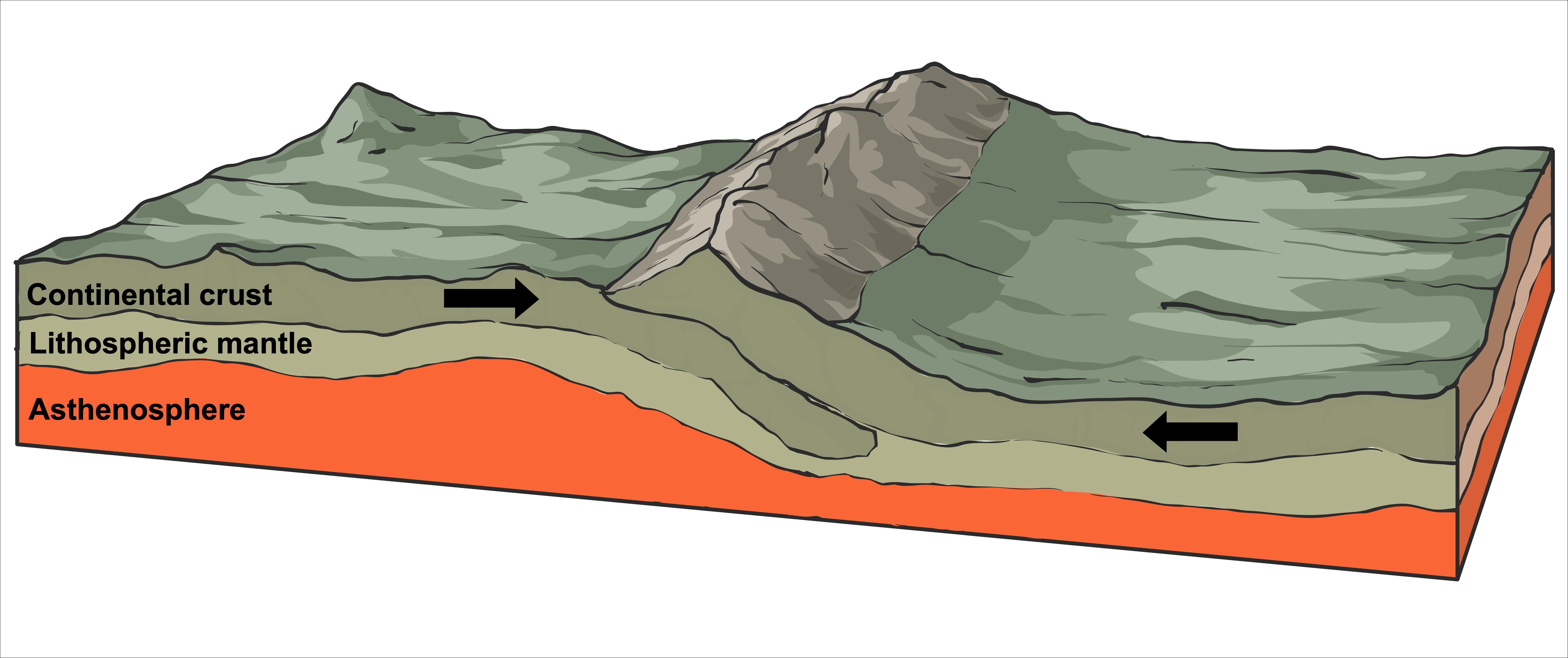
When two continental tectonic plates converge, they cannot submerge into the mantle due to their composition. This lack of subduction leads to the plates crumpling upwards, forming fold mountains like the Himalayas. This geological event can result in shallow-focus earthquakes. However, it does not lead to volcanic activity, as no magma is involved in this process. Over time, these fold mountains can continue to experience compression, leading to further elevation.
Oceanic-oceanic crust destructive plate margin
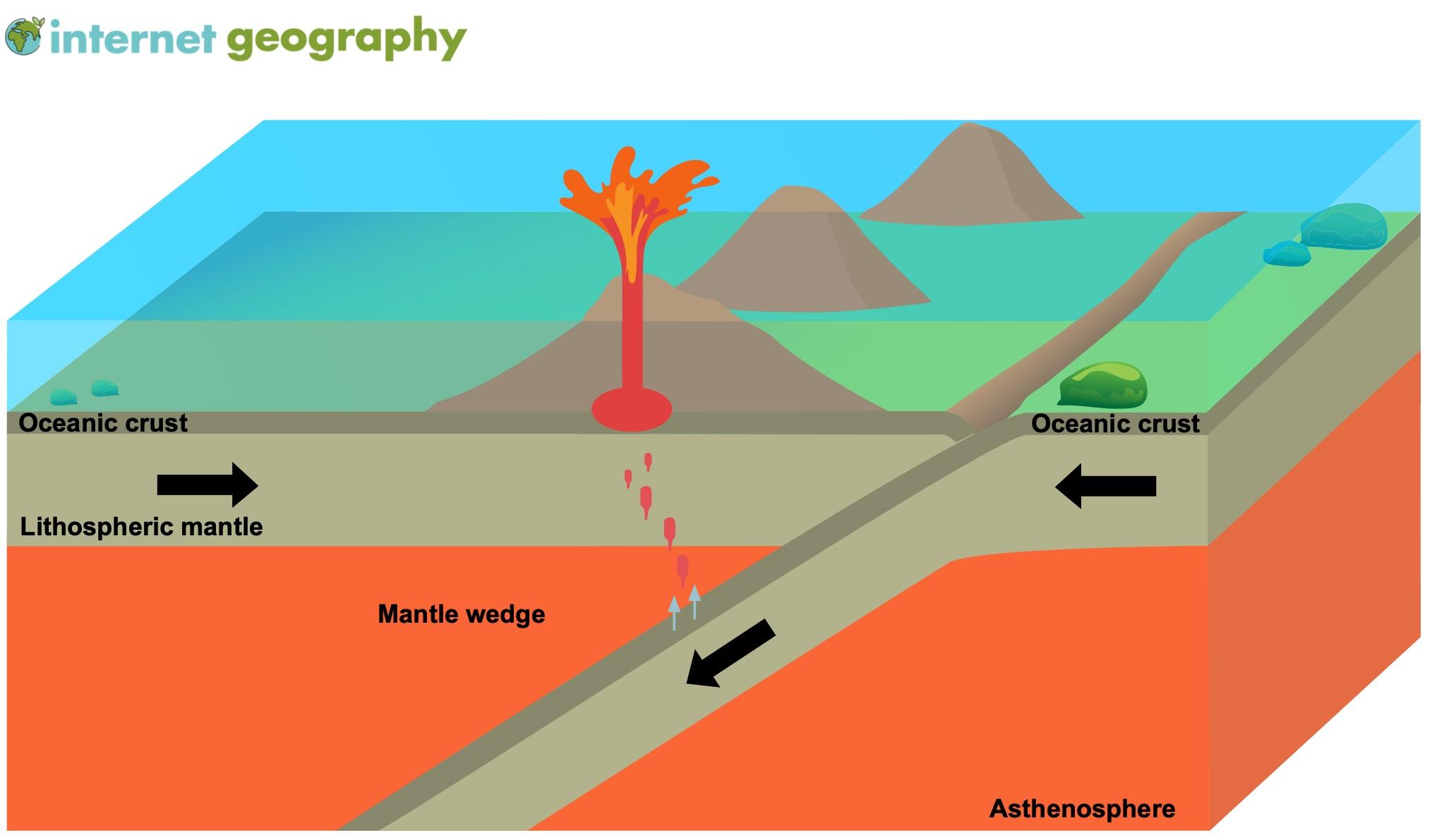
Oceanic-oceanic destructive plate margin
When two oceanic tectonic plates converge, the older plate subducts the relatively younger plate. This happens because oceanic plates become colder and denser as they age. This process results in subduction. Ocean water drawn down within the sinking oceanic crust is released into the mantle, reducing its melting point and leading to partial melting and magma formation, which can rise to the surface. As this molten material encounters ocean water, it cools quickly, forming volcanic island arcs similar to those found in the Caribbean Sea.
Examples of oceanic-continental plate margins include the Pacific Plate and Eurasian Plate, and the Nazca Plate and the South American Plate.
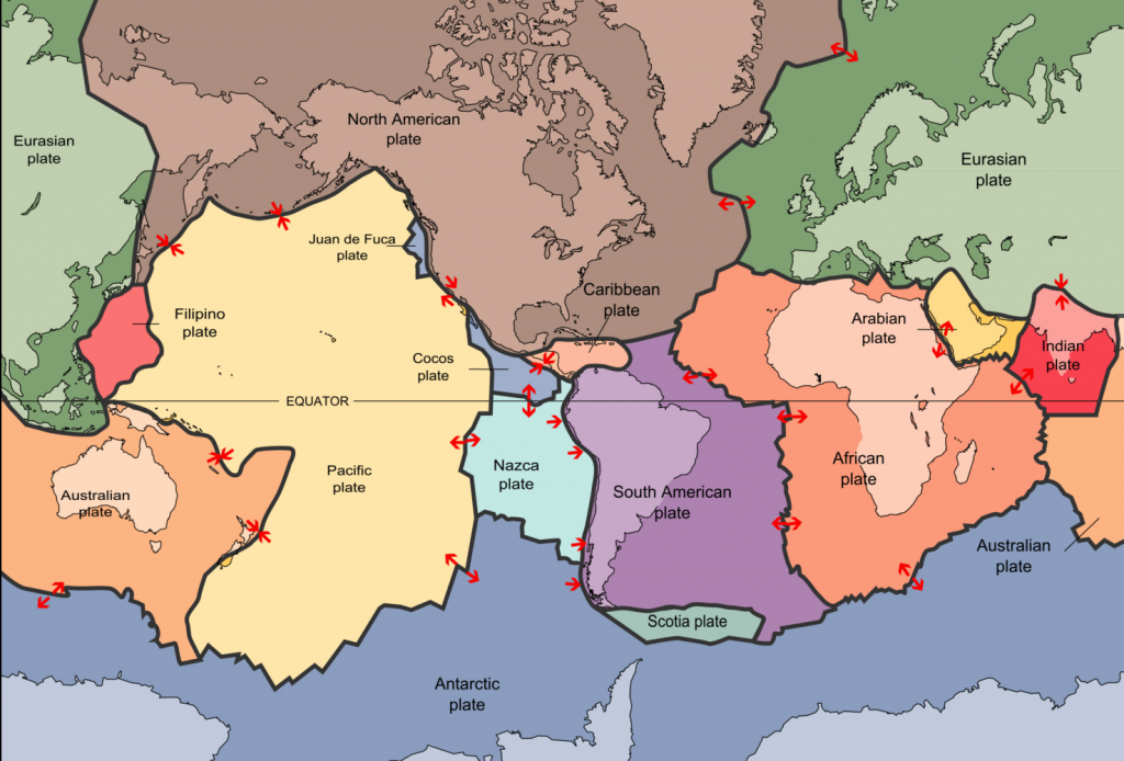
A map to show the Earth’s plates
A seismic wave is a mechanical wave of acoustic energy that travels through the Earth or another planetary body. It can result from an earthquake (or generally, a quake), volcanic eruption, magma movement, a large landslide and a large man-made explosion that produces low-frequency acoustic energy. Seismic waves are studied by seismologists, who record the waves using seismometers, hydrophones (in water), or accelerometers. Seismic waves are distinguished from seismic noise (ambient vibration), which is persistent low-amplitude vibration arising from a variety of natural and anthropogenic sources.
The propagation velocity of a seismic wave depends on density and elasticity of the medium as well as the type of wave. Velocity tends to increase with depth through Earth’s crust and mantle, but drops sharply going from the mantle to Earth’s outer core.
Earthquakes create distinct types of waves with different velocities. When recorded by a seismic observatory, their different travel times help scientists locate the quake’s hypocenter. In geophysics, the refraction or reflection of seismic waves is used for research into Earth’s internal structure. Scientists sometimes generate and measure vibrations to investigate shallow, subsurface structure.