
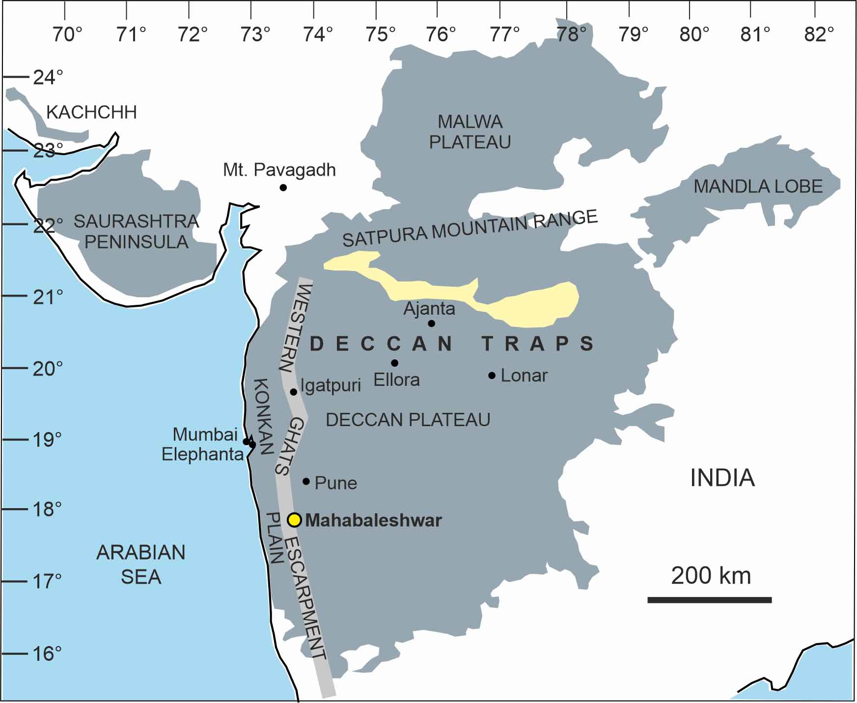
The Deccan Traps are one of the largest volcanic features on Earth, located in west-central India. They consist of layers of basaltic lava flows formed through massive volcanic eruptions about 66 million years ago during the Late Cretaceous period. This event is linked to the end-Cretaceous mass extinction, which saw the disappearance of the dinosaurs.
The name “Deccan Traps” derives from the Sanskrit word “Dakshin” (south) and the Swedish word “Trappa” (stair), referring to the step-like formation of the basaltic layers. These traps cover an area of over 500,000 square kilometers, initially estimated to have spread across an area almost twice as large.
The eruptions responsible for the Deccan Traps lasted for about 30,000 years, with intermittent phases of activity. The sheer volume of lava emitted is estimated at over 1 million cubic kilometers. The release of carbon dioxide, sulfur dioxide, and other gases during these eruptions contributed to global climate change, leading to environmental stress.
The Deccan Traps are significant for both their geological and paleontological importance. They contain a wealth of fossils, particularly microfossils, that help researchers understand the changes in biodiversity across the Cretaceous-Paleogene (K-Pg) boundary.
Today, the region is rich in black soil, making it highly fertile and suitable for agriculture. The Deccan Traps also hold significant deposits of minerals, including zeolites, which are widely used in industrial applications. This region remains an area of intense scientific research, particularly in understanding Earth’s history and volcanic activity.
The term „Deccan Traps‟ was first used by W H. Sykes (1833). The term Deccan’ is derived from the vernacular “Dakshin’ meaning South. Medlicott (1873) applied a short term for basaltic sedimentary rock as ‘Trap’.
In India, volcanic rock formation occurred in late Cretaceous or early Eocene period which is known as Deccan Traps. It covers an area of 77,220 sq. kilometers. In the word of Prof. Sahni “An Episode of Tertiary Era” Deccan Trap is the greatest volcanic formation in Indian geology. It is thought that towards the end of Cretaceous period subsequent to the deposition of Bagh and the Lameta beds, a large part of Peninsula was affected by outburst of the volcanic energy, resulting in the eruption of lava in large quantity and associated pyroclastic materials (Pascoe, 1950). This eruption proceeded from fissures and cracks in the surface of earth, from which highly liquid lava come out intermittently, till a thickness of some thousand feet of horizontal sheet of basalt of igneous origin had resulted, obliterating all the previously existing topography of the country and converted into large volcanic plateau. The DeccanTraps of India cover a large area of Kutch, Saurashtra, Gujrat, Maharashtra, Madhya Pradesh and Andhra Pradesh.
While according to Vredenburg (1910) Deccan trap formation is not entirely of basalts. In some parts, the sheets of basaltic lava are interbedded with great mass of tuff. During intervals between the two successive volcanic eruption fresh water lakes were formed in which sedimentation took place. These sedimentary beds are known as Intertrappean beds which preserved fossil flora and fauna.
Tropical evergreen forests
The tropical evergreen forests do not shed their leaves at a time and hence they are green throughout the year. These forests are found in areas with high temperatures and heavy rainfall exceeding 250 cm. Which places in India fall under this category? They are found mainly on the western slopes of the Western Ghats and hills of northeastern states of Assam, Nagaland, Meghalaya, Tripura, Manipur Lakshadweep and Andaman – Nicobar islands.
The main trees that we can see in these forests are Teak, Rosewood, Ebony, Mahogany, Gurjan and Champa.
Tropical deciduous forests
Tropical deciduous forests occur in regions with heavy rainfall for part of the year followed by a marked dry season. The term deciduous means- tend to fall off. The trees in these forests shed their leaves. But do you know why? this is because of the survival instinct of the trees. To overcome the loss of water in the dry season, they shed their leaves. This helps them conserve water. As they shed their leaves in spring and early summer and grow back during the monsoon season they are also known as monsoon forests. These are the most widespread forest in India occupying the eastern slopes of the Western Ghats including Maharashtra, Karnataka, Kerala and Tamil Nadu, Chotanagpur plateau, foothills of the Himalayas, and parts of Odisha and West Bengal. The trees found in these forests are Teak, Sal, Sandalwood, Kusum, Kanju, Myrobalan, Siris, Mango, Neem and Tamarind.
Scrub forests and grassland
This vegetation consists of many southern tropical thorns which are scrub-type forests.
These forests are mostly found in the kutch and the fringes of the Thar desert. And grasslands are mainly found in eastern Rajasthan, Punjab, parts of the Western Ghats and the Cardamom hills. These forests have rainfall between 60 to 100 cm. And the main trees found in these forests are the scrub with short coarse grass, thorny trees and bushes
Desert vegetation
The vegetation in the desert is very dry and sparse as it receives rainfall only between 10 to 50 cm. These deserts consist of sand that has accumulated over the last 1.8 million years. This vegetation is mostly found in the Thar desert including parts of Punjab, Haryana, Rajasthan and the Deccan plateau. Also, we can see scattered trees and thorny bushes like Cacti, Acacias, Palms, Euphorbias, Jhand, Khair, Kolko, Babul, Cacti and Khejra.
Mountain forest
Mountain forests are found on the slopes of the mountain which are mostly found in the Himalayas and to a small extent in the Niligiri hills. The most common trees in these areas are Oak, Chestnut, Ash, Beech, Pine, Cedar, Spruce, Fir, Deodar and Walnut.
Mangrove forests
Mangroves are a special type of vegetation. And they are found in the intertidal regions where freshwater and saltwater intermixes, in the bays, estuaries, creeks, and lagoons. They are the salt-tolerant variety of plants and waterlogged soil that doesnt have enough oxygen content. Therefore, we can say that it can survive in harsh conditions.
They are found in the wet marshy regions in the river deltas like Ganga, Mahanadi, Godavari, Krishna, and Kaveri. The most common trees found here are Rhizophora, Canes, Screw pipe, Palms, Sundari etc.
Dryland farming is a method of agriculture that focuses on cultivating crops in regions with limited water availability and unpredictable rainfall.
What is Dryland Farming?
Dryland farming is also known as dry farming or dryland agriculture. It is a type of agriculture that is practiced in areas with low rainfall or limited water resources. It is a set of techniques and management practices used by farmers to adapt to the lack of moisture in a given crop cycle. Dryland farming is distinguished from irrigated agriculture, which uses artificial means to supply water to crops.
Dryland Crops Examples
Examples of dryland crops include millets (such as pearl millet and sorghum), pulses (like chickpeas and lentils), drought-tolerant varieties of wheat and barley, and oilseeds such as sunflower and sesame. These crops have adapted to withstand water scarcity and can thrive in dryland environments.
Various Features of Dryland Farming
Dryland farming in India is characterized by several distinct features:
- Low and Erratic Rainfall: Areas practicing dryland farming receive an average annual rainfall of less than 750 mm. This is irregularly distributed throughout the year.
- Crop Adaptation: Dryland farming relies on crop varieties that are adapted to low-moisture conditions. This includes millets, pulses, and oilseeds.
- Soil Moisture Conservation: Soil moisture conservation techniques play a pivotal role in dryland farming. This includes minimum tillage, mulching, and contour farming.
- Water Harvesting: Rainwater harvesting techniques, such as runoff farming and micro catchments, are essential for supplemental irrigation.
- Risk Management: Dryland farming involves managing risks associated with drought and water stress. This is through crop diversification, intercropping, and livestock integration.
Key Processes of Dryland Farming
Dryland farming emphasizes the conservation of soil moisture to maximize crop production. This involves practices such as:
- Tillage: Tillage techniques are used to create a soil structure that promotes water infiltration and storage. Minimum tillage or no-till methods are often preferred to preserve moisture.
- Mulching: Mulching involves covering the soil surface with organic materials to reduce evaporation.
- Contour Farming: Contour farming involves planting crops along the contours of the land. This is to slow down water runoff and promote infiltration.
Dryland farmers employ various techniques to harvest rainwater for later use in irrigation. These techniques include:
- Runoff Farming: Runoff farming involves capturing and diverting rainwater from surrounding areas into fields.
- Microcatchments: Microcatchments are small depressions created in the soil. This is to collect and concentrate rainwater for crop growth.
- Crop Selection: Dryland farmers carefully select crops that are adapted to low-water conditions. Drought-resistant crops like sorghum, millet, and legumes are often preferred.
Maintaining healthy soil conditions is crucial for dryland farming. This involves practices such as:
- Organic Matter Management: Increasing organic matter in the soil improves water retention.
- Erosion Control: Erosion control measures protect the soil from wind and water erosion.
Types of Dryland Farming
Dryland farming practices can be divided into traditional ones and more modern conservation agriculture methods.
Traditionally, cluster planting has been used, where crops are planted close together in clusters instead of rows. Only the cluster area is tilled, leaving the soil in between undisturbed to conserve moisture. The ridge and furrow method has been used on slopes, making ridges and furrows to slow runoff and allow moisture absorption. Crops are planted on the ridges. Mulching by covering the soil with crop residue, weeds or gravel reduces evaporation and moderates temperatures. Zai pits, shallow pits dug on hard land, concentrate runoff water for establishing plants.
More recently, conservation agriculture practices like minimum tillage, where the soil is disturbed minimally and zero tillage with direct sowing into untilled soil, have been adopted. They conserve moisture and minimize erosion. Crop rotation, growing different crops in sequence with varied demands, helps maintain soil fertility.
Water management practices utilize watershed management, making contoured bunds, trenches and structures to harvest runoff water. Wells are recharged during rains to maintain groundwater for irrigation. Rainwater harvesting collects rainwater from fields and roofs in reservoirs for irrigation.
Innovative technologies involve developing drought-resistant crop varieties requiring less water and being able to tolerate moisture stress. Micro irrigation systems like drip and sprinklers apply water directly to crop roots, improving efficiency. Precision agriculture uses sensors, drones and GPS to optimize nutrient and water applications based on precise crop needs.
About Dryland Farming in India
Dryland farming is also known as rainfed agriculture. It is an agricultural system practiced in areas with low and erratic rainfall. It is a crucial aspect of Indian agriculture. It encompasses around 68% of the country’s cultivated land.
Importance of Dryland Farming in India
Dryland farming holds immense importance for India’s agricultural landscape:
- It contributes significantly to the country’s food production. This is particularly of millets, pulses, and oilseeds.
- It provides employment and income-generating opportunities for a large proportion of the rural population.
- It promotes nutritional security by providing access to diverse and nutritious food grains.
- It maintains ecological balance in dryland ecosystems by promoting sustainable land management practices.
Government Initiatives Towards Dryland Farming in India
The Indian government has implemented various initiatives to promote and strengthen dryland farming practices:
- National Rainfed Area Authority (NRAA): The NRAA spearheads the development and implementation of policies and programs for rainfed agriculture.
- Watershed Development Programs: These programs focus on soil and water conservation measures in dryland areas.
- Climate-Resilient Agriculture: The government promotes climate-resilient agriculture practices. This helps enhance adaptability to changing climatic conditions.
- Farmer Empowerment: Training and extension programs empower farmers with knowledge and skills for effective dryland farming.
Benefits of Dryland Farming
Dryland farming offers several advantages, including:
- It promotes sustainable agriculture by utilizing natural resources efficiently and minimizing environmental impact.
- It enhances resilience to climate change and variability. This is by relying on drought-tolerant crops and water conservation practices.
- Food Security: It contributes to food security. This is particularly true in regions with limited irrigation potential.
- Rural Livelihoods: It supports the livelihoods of millions of farmers and rural communities in dryland areas.
Problems of Dryland Agriculture
Dryland agriculture faces several challenges, including water scarcity, soil erosion, limited access to irrigation facilities, unpredictable weather patterns, and the risk of crop failure due to droughts. Lack of financial resources, inadequate infrastructure, and limited knowledge and technology also hinder the development of dryland farming.
Dryland Farming Technology
Several technological advancements have enhanced dryland farming practices:
- Drought-Resistant Crop Varieties: Development of high-yielding, drought-resistant crop varieties have improved productivity.
- Precision Agriculture: Precision agriculture techniques, such as soil mapping and variable-rate irrigation, optimize resource use.
- Weather Forecasting: Weather forecasting tools help farmers make informed decisions about crop management and water conservation.
- Information and Communication Technology (ICT): ICT platforms provide access to agricultural information and services for dryland farmers.
- Climate-Smart Agriculture: Climate-smart agriculture approaches integrate sustainable practices to mitigate climate change impacts.
- Mica is a naturally occurring non-metallic mineral that is based on a collection of silicates. Mica occurs in the veins of the Metamorphic rocks.
- Mica is common in igneous and metamorphic rock and is occasionally found as small flakes in sedimentary rock.
- It is chemically inert, stable, and does not absorb water.
- Mica is a very good insulator that has a wide range of applications in the electrical and electronics industry.
- It can withstand high voltage and has a low power loss factor.
- It is used in toothpaste and cosmetics because of its glittery appearance. It also acts as a mild abrasive in toothpaste.
- It has a unique combination of elasticity, toughness, flexibility, and transparency.
Mica Reserves in India
- Mica is widely distributed in India, the minerals bearing Mica is found in the states of Andhra Pradesh, Maharashtra, Jharkhand, Odisha, Rajasthan, etc.
- State-wise total resource distribution of Mica is as follows:-
- Andhra Pradesh leads with 41% share in the country’s total resources followed by
- Rajasthan (21%)
- Odisha (20%)
- Maharashtra (15%)
- Bihar (2%) and
- The remaining 1% is in Jharkhand and Telangana together.
Mica Distribution in India
Andhra Pradesh:
- Andhra Pradesh is the largest mica producing state of India. In Andhra Pradesh. Nellore district produces the best quality mica.
- Vishakhapatnam, West Godavari, and Krishna are other important mica-producing districts.
Rajasthan:
- Second largest producer.
- In Rajasthan, the mica belt extends for about 320 kms from Jaipur to Bhilwara and around Udaipur.
- Bhilwara district located in this belt is the most imported producer of Mica.
Jharkhand:
- Third largest producer.
- Mica is found in a belt extending for about 150 km in length and 32 km in width from the Gaya district of Bihar to Hazaribagh and Koderma districts of Jharkhand. This Mica belt runs in an East-West direction. This belt contains the richest deposits of high-quality ruby mica.
- Kodarma (largest reserve of mica in the world), Giridih, and Domchanch are the chief collecting centers (located in this belt) where Mica is processed.
- Apart from this Munger in Bihar also have sufficient mica deposits.
- The main centres of mica production in this belt are Kodarma, Dhorhakola, Domchanch, Dhab, Gawan, Tisri, Chakai and Chakapathal.
Karnataka:
- Mica deposits occur in Mysuru and Hasan districts of Karanataka
Tamil Nadu:
- In Tamil Nadu, Coimbatore, Tiruchirapalli, Madurai and Kanniyakumari districts
Kerala:
In Kerala, Mica deposits are found in Alleppey district.
Maharashtra:
- Ratnagiri in Maharashtra has rich mica deposits.
West Bengal:
- Purulia and Bankura in West Bengal are known for mica deposits.
Mica Exports
- India is the largest exporter of mica.
- Certain grades of Indian mica are and will remain vital to the world’s electrical industries.
- Major exports are carried out through Kolkata and Vishakhapatnam ports.
- Important imports of Indian mica are Japan (19%), the USA (17%), U.K, etc.
 - UPSC 1")
Distribution and Density of Population
- Population distribution patterns show how people are spread out across a place. This helps us understand what the population looks like in different areas. Density, on the other hand, tells us how crowded or sparse a specific area is with people. These patterns help us learn more about the population in different regions.
- “Population distribution” describes how people are spread across the Earth’s surface, while “population density” refers to the number of people living in each unit of area, such as per square mile.
- India has a total population of 121 crores (or 1.21 billion) according to Census, 2011. Further,
- India’s population currently stands at 1.37 billion (2019, United Nations Population Division.), which accounts for approx. 17% of the world’s population.
- India’s 1.37 billion people are spread unevenly across its vast land area of 3.28 million square kilometers, which makes up 2.4 percent of the world’s total area. As a result, India’s population density is approximately 382 persons per square kilometer.
Distribution of Population in India
India’s Population Distribution by Density
- Population density refers to the number of people living in a specific area. It helps us understand how the population is spread across a given area of land. By using population density, we can get a clearer view of how people are distributed across different areas, especially when the population is not evenly spread out.
- The density of population in India (2011) is 382 persons per sq km. There has been a steady increase of about 265 persons per sq km over the last 60 years as the density of population increased from 117 persons/ sq km in 1951 to 382 persons/sq km in 2011.
- The eastern region had the highest population density in India, with 625 people living in every square kilometer. In contrast, the North East region had the lowest density, with 176 people per square kilometer.
- In terms of population density, the eastern region was followed by the central Indian region, which had a density of 417 people per square kilometer. The southern region had a density of 397, the western region had 344, and the northern region had 267 people per square kilometer.
- The population densities of the Central, Northern, and Eastern regions in India increased at a higher rate compared to the Western, North Eastern, and Southern regions.
Factors Influencing the Distribution of Population
- Geographical Factors
- Economic Factors
- Social and Cultural Factor
- Demographic factors
- Political factors
Geographical Factors
- Availability of water: Water is crucial for survival as it serves various purposes such as drinking, bathing, cooking, cattle, industrial, and navigational needs. People naturally tend to live in places where they can easily access fresh water. River valleys, known for their reliable water supply, tend to be densely populated, as seen in ancient civilizations like the Indus and Mesopotamia.
- On the contrary, desert regions have low population density due to the scarcity of water. However, oases within deserts have higher population density as they provide limited but essential water resources for settlement.
- Landforms (Relief): People generally prefer living in flat plains and gentle slopes because these areas are conducive to farming, road construction, and industrial development. Flat regions are more favorable for agriculture and offer easier opportunities for infrastructural development.
- In contrast, mountainous and hilly terrains pose challenges for transport infrastructure and initial agricultural and industrial growth, resulting in lower population densities. For instance, the Ganga plains, characterized by flat terrain, are highly populated, whereas the mountainous regions in the Himalayas have sparse populations.
- Additionally, the thin air at altitudes higher than 4000 meters makes breathing difficult and physical exertion strenuous. Settlements are primarily found in high plateaus where farming and communication are relatively feasible, while other areas at such high altitudes have settlements mostly concentrated in valleys due to these challenges.
- Climate and vegetation: Regions experiencing very heavy rainfall or extreme climates often have lower population densities. In extremely harsh environments like very hot or cold deserts, living conditions are extremely uncomfortable and sometimes nearly impossible.
- Similarly, rainforests tend to be less populated compared to grasslands.
- On the contrary, areas with more comfortable climates, where there is less seasonal variation, tend to attract more people due to the pleasant living conditions they offer.
- Soils: People need food to survive and thrive. Agriculture is the primary source of such food. Now, fertile soils are very important for agricultural and allied activities.
- Therefore,areas which have fertile soils have more people living on them, as these can support intensive agriculture.
Economic Factors
- Minerals: Regions rich in mineral deposits often attract industrial activities due to the presence of valuable resources. This leads to the creation of job opportunities in mining and associated industries.
- Consequently, skilled and semi-skilled workers migrate to these areas, contributing to their higher population density.
- Urbanisation: Cities offer better employment opportunities, educational and medical facilities, better means of transport and communication. Good civic amenities and the attraction of city life draws people to the cities.
- It leads to rural to urban migration and cities grow in size. Mega cities of the world continue to attract a large number of migrants every year.
- Industrialization: Industrial belts provide job opportunities and attract large numbers of people. These include not just factory workers but also transport operators, shopkeepers,bank employees, doctors, teachers and other service providers.
Social and Cultural Factors
- Certain places are popular due to their religious or cultural importance, drawing a large number of people. For instance, cities like Puri, Tirupati, and Haridwar are densely populated because of their significance in religious contexts.
Political Factors
- In the same way – people tend to move away from places where there is social and political unrest. For example, many refugee migrants in the East and the North East have crossed over from Bangladesh and Myanmar.
- Governments often create policies or provide incentives to encourage people to reside or remain in specific areas. For example, the Bru/Reang tribes from Mizoram, who settled in Tripura and southern Assam, became the most populous tribe in those regions. A “four-corner agreement” was recently signed among the Centre, state governments of Tripura and Mizoram, and the Bru-Reang representatives. This agreement facilitated their permanent settlement in Tripura by granting them permanent resident status.
Rail transport in India is one of the largest and most significant railway networks in the world, managed primarily by Indian Railways, a government-owned entity under the Ministry of Railways. As of 2024, it operates over 68,000 kilometers of track and connects more than 7,300 stations, making it a lifeline for millions of passengers and a backbone for freight transport.
Established in 1853, when the first train ran between Mumbai and Thane, the Indian Railways has grown into the fourth-largest rail network globally. It handles over 23 million passengers daily and transports approximately 1.5 billion tons of freight annually, covering goods like coal, cement, food grains, and steel.
The rail system is categorized into broad gauge, meter gauge, and narrow gauge, with broad gauge forming the majority. India’s railway infrastructure includes a mix of diesel, electric, and heritage steam locomotives. Efforts toward electrification are significant, with more than 85% of the network electrified to reduce carbon emissions and improve efficiency.
India also boasts some of the world’s iconic trains, such as the Palace on Wheels and the Darjeeling Himalayan Railway, a UNESCO World Heritage Site. The introduction of semi-high-speed trains like the Vande Bharat Express reflects modernization efforts.
Railways are vital for economic development, providing affordable transport for passengers and industries. Initiatives like Dedicated Freight Corridors (DFC), modern station redevelopment projects, and digital ticketing systems are transforming the network.
Despite its scale, Indian Railways faces challenges like overcrowding, aging infrastructure, and safety concerns, which are being addressed through ambitious projects under the National Rail Plan 2030
Slums in Indian cities are a significant urban challenge, reflecting the socio-economic disparities in the country. According to the 2011 Census, over 65 million people, constituting approximately 22% of the urban population, live in slums. These settlements often arise due to rapid urbanization, rural-to-urban migration, and the unaffordability of formal housing. Major cities like Mumbai, Delhi, Kolkata, Chennai, and Hyderabad have substantial slum populations, with Dharavi in Mumbai being one of Asia’s largest slums, housing nearly 1 million people in just 2.1 square kilometers.
Slums are characterized by overcrowding, poor sanitation, and inadequate access to essential services like clean water, electricity, and healthcare. Housing in these areas is often makeshift, constructed with improvised materials, and vulnerable to extreme weather conditions. The lack of proper toilets and drainage systems leads to waterborne diseases, while high population density increases the risk of health crises, as seen during the COVID-19 pandemic. Additionally, most slum dwellers are employed in the informal sector, facing unemployment or underemployment, which further limits their quality of life.
To address these challenges, the government has launched initiatives like the Pradhan Mantri Awas Yojana (PMAY), which aims to provide affordable housing for the urban poor, and the Rajiv Awas Yojana, which focused on creating slum-free cities. State-level programs like Maharashtra’s Slum Rehabilitation Authority (SRA) also work on slum redevelopment. However, the success of these initiatives depends on effective implementation and active community participation to ensure sustainable improvement in the living conditions of slum dwellers.
The regional pattern of economic development in India is marked by significant disparities due to historical, geographical, and policy-driven factors. States like Maharashtra, Tamil Nadu, Gujarat, and Karnataka have emerged as major hubs of industrial and economic growth, while states in the northeast, central India, and parts of eastern India lag behind. These disparities are evident in metrics like per capita income, industrial output, and human development indices.
Western and southern states, including Gujarat, Kerala, and Telangana, benefit from robust industrial infrastructure, ports, and proactive policies encouraging foreign direct investment (FDI). Cities like Mumbai, Bengaluru, and Chennai are centers of IT, finance, and manufacturing, contributing significantly to national GDP. In contrast, states like Bihar, Odisha, and Jharkhand rely heavily on agriculture and mineral extraction, facing challenges like low industrialization, poor infrastructure, and limited investment.
The Green Revolution created a north-south divide in agricultural productivity, with states like Punjab, Haryana, and Western Uttar Pradesh achieving high yields, while eastern India lagged behind due to inadequate irrigation and poor adoption of technology. Similarly, northeastern states face developmental constraints due to geographical isolation and limited connectivity.
To address these disparities, initiatives like the Aspirational Districts Program and enhanced budgetary allocations under schemes like PM Gati Shakti and Smart Cities Mission aim to promote inclusive growth. Investments in infrastructure, education, and healthcare, alongside decentralized planning, are essential for reducing regional imbalances and achieving balanced economic development across India.
The origin of Himalayan drainage is deeply linked to the geological evolution of the Himalayan mountain range and the Indian subcontinent. The Himalayan rivers are primarily a result of tectonic activity associated with the collision of the Indian Plate with the Eurasian Plate, which began around 50 million years ago. This tectonic collision uplifted the Himalayan region, altering the courses of pre-existing rivers and giving rise to the modern Himalayan drainage system.
The Indus, Ganga, and Brahmaputra river systems are the three major drainage systems originating in the Himalayas. These rivers are classified into two categories: antecedent rivers, which predate the Himalayan uplift, and subsequent rivers, which developed later. Antecedent rivers like the Indus, Satluj, and Brahmaputra maintained their courses by cutting through the rising mountains, forming deep gorges. Subsequent rivers, such as the Chambal and Betwa, adjusted their courses along the softer strata formed after the uplift.
The Himalayan rivers are perennial, as they are fed by both glacial melt and monsoonal rainfall, ensuring year-round flow. The drainage system is characterized by a radial pattern, particularly in areas where rivers radiate from glacial origins, and a dendritic pattern in the plains.
The Himalayan drainage has played a crucial role in shaping the Indo-Gangetic plains, providing fertile alluvial soil and sustaining agriculture. Over millions of years, these rivers have carved valleys and transported massive amounts of sediment downstream, influencing the geography and ecology of the Indian subcontinent. Understanding this drainage system is vital for managing water resources, mitigating floods, and conserving the Himalayan ecosystem.
Winter rainfall in India is a significant climatic phenomenon primarily caused by the western disturbances and the northeast monsoon. Western disturbances are extratropical storms originating in the Mediterranean region, which travel eastward and impact northwestern India during the winter months, typically from December to February. These disturbances bring light to moderate rainfall and snowfall to the northern plains and Himalayan region, particularly in states like Punjab, Haryana, Delhi, Rajasthan, and Uttar Pradesh. The rainfall is crucial for the Rabi crop, especially wheat and mustard, as it supplements irrigation and improves soil moisture.
In southern India, the northeast monsoon contributes to winter rainfall, especially in Tamil Nadu, Puducherry, and parts of Andhra Pradesh. This rainfall occurs between October and December, as the northeast trade winds pick up moisture from the Bay of Bengal and cause precipitation. Tamil Nadu receives nearly 50% of its annual rainfall during this period, making it critical for the region’s agriculture and water reservoirs.
Winter rainfall is usually low in intensity compared to the southwest monsoon but plays a vital role in maintaining the hydrological balance. It also influences the temperature patterns, with rainfall often followed by a drop in temperatures, causing cold waves in northern India.
Despite its benefits, excessive rainfall due to intensified western disturbances can lead to crop damage and urban flooding in some areas. The variability of winter rainfall is influenced by global climatic phenomena such as El Niño and La Niña, impacting its distribution and intensity across different regions of India.
The production of atomic minerals in India is vital for the country’s nuclear energy program and other strategic applications. Atomic minerals such as uranium, thorium, zirconium, beryllium, and monazite are essential for generating nuclear power and supporting advanced technologies. India has rich reserves of these minerals, particularly in regions like the Eastern Ghats, the Aravallis, and the coastal areas of Kerala and Tamil Nadu.
Uranium, a primary fuel for nuclear reactors, is extracted from deposits in states like Jharkhand, Andhra Pradesh, Meghalaya, and Rajasthan. The Jaduguda mines in Jharkhand are one of India’s oldest and most significant sources of uranium. The Tummalapalle mine in Andhra Pradesh is estimated to hold one of the largest uranium reserves in the world.
Thorium, another critical atomic mineral, is primarily obtained from monazite sands found along the coastal stretches of Kerala, Tamil Nadu, and Odisha. India possesses the world’s largest reserves of thorium, which is being explored for use in thorium-based reactors as part of India’s three-stage nuclear program.
Other atomic minerals like zirconium and beryllium, used in nuclear reactors and aerospace industries, are extracted from deposits in Kerala, Tamil Nadu, and parts of Chhattisgarh. Ilmenite, found in beach sands, is another valuable mineral used for producing titanium and nuclear-related applications.
The Atomic Minerals Directorate for Exploration and Research (AMD) under the Department of Atomic Energy (DAE) oversees the exploration and production of these minerals. India’s focus on self-reliance in nuclear energy and increasing the share of nuclear power in its energy mix underscores the strategic importance of atomic mineral production.
Dry farming in India refers to agricultural practices in regions with low rainfall (less than 75 cm annually) and without reliable irrigation facilities. It is predominantly practiced in arid and semi-arid regions, covering states like Rajasthan, Madhya Pradesh, Karnataka, Andhra Pradesh, and Maharashtra. Approximately 60% of India’s cultivated area falls under dry farming, making it essential for ensuring food security and sustaining rural livelihoods.
The development of dry farming has been driven by the need to adapt to climatic variability and water scarcity. Key strategies include the cultivation of drought-resistant crops like millets, pulses, oilseeds, and sorghum, which can thrive in low-moisture conditions. Soil conservation techniques, such as contour plowing, mulching, and terracing, are employed to reduce soil erosion and retain moisture. The use of early-maturing crop varieties and mixed cropping helps minimize the risks associated with erratic rainfall.
Government initiatives like the Integrated Watershed Management Program (IWMP) and the promotion of rainwater harvesting have been instrumental in improving water availability in dry farming areas. Additionally, programs under the National Mission for Sustainable Agriculture (NMSA) encourage the adoption of climate-resilient technologies, micro-irrigation, and organic farming practices.
Research institutions like the Central Research Institute for Dryland Agriculture (CRIDA) play a crucial role in developing innovative technologies and disseminating knowledge to farmers. Despite these efforts, challenges such as low productivity, soil degradation, and dependence on monsoons persist, necessitating continued investment in infrastructure, farmer education, and policy support to enhance the sustainability and profitability of dry farming in India.
Inland waterways in India play a vital role in the country’s transportation network by providing an economical and environmentally friendly mode of cargo and passenger movement. India has an extensive network of 14,500 km of navigable waterways, which includes rivers, canals, backwaters, and creeks. To enhance this sector, the government has identified 111 National Waterways (NWs) under the National Waterways Act, 2016.
The most prominent inland waterways include National Waterway-1 (NW-1) on the Ganga River from Haldia in West Bengal to Prayagraj in Uttar Pradesh, spanning 1,620 km; NW-2 on the Brahmaputra River, stretching 891 km from Dhubri to Sadiya in Assam; and NW-3, the West Coast Canal in Kerala, covering 205 km. Other significant waterways include NW-4 (Kakinada-Puducherry canals) and NW-5 (East Coast Canal).
Inland waterways are managed by the Inland Waterways Authority of India (IWAI), established in 1986, which oversees the development and regulation of these routes. Waterways are increasingly being used for transporting bulk cargo, such as coal, fertilizers, food grains, and cement, as well as for tourism and ferry services.
Advantages of inland waterways include reduced fuel consumption, lower transportation costs, and minimal environmental impact compared to road and rail transport. However, challenges such as seasonal variations in water flow, siltation, and inadequate infrastructure hinder their full potential. To address these issues, projects like the Jal Marg Vikas Project (JMVP) aim to develop NW-1 with better dredging, terminals, and modern vessels.
Inland waterways offer immense potential to boost trade, especially for northeastern states and landlocked regions, making their development critical for India’s sustainable economic growth.
Water pollution in India is a critical environmental challenge, threatening the country’s water resources, ecosystems, and public health. Over 70% of India’s surface water is contaminated, with rivers, lakes, and groundwater suffering from pollutants such as industrial waste, sewage, agricultural runoff, and plastic debris. The Central Pollution Control Board (CPCB) has identified more than 350 polluted river stretches across the country, with major rivers like the Ganga, Yamuna, and Godavari severely affected.
Industrial discharge is a significant contributor to water pollution, with untreated chemicals, heavy metals, and toxic effluents being released into water bodies. Cities generate over 62 billion liters of sewage daily, but only 20% is treated, leaving the majority to contaminate rivers and lakes. Agricultural runoff, laden with pesticides and fertilizers, infiltrates both surface and groundwater, further degrading water quality. Additionally, plastic pollution and urban waste dumping exacerbate the problem.
The impacts of water pollution are far-reaching, including health issues like waterborne diseases (e.g., cholera, dysentery, and hepatitis), reduced agricultural productivity, and harm to aquatic ecosystems. It also affects drinking water supplies, with more than 80% of rural households lacking access to clean water.
Efforts to address this issue include government initiatives like the Namami Gange Program, focusing on cleaning the Ganga River, and the National Water Mission, aimed at water conservation and management. Strict enforcement of pollution control laws, expansion of sewage treatment facilities, and promotion of sustainable agricultural practices are essential to mitigate water pollution in India. Collaborative efforts involving communities, industries, and policymakers are crucial to safeguard the country’s water resources for future generations.
Laterite soil in India is a distinct type of soil formed in regions with high temperatures and heavy rainfall, undergoing intense leaching due to frequent wet and dry spells. This process leads to the removal of silica and the accumulation of iron oxide and aluminum, giving the soil its characteristic red or yellowish color. Laterite soil is predominantly found in western coastal regions, Eastern Ghats, parts of Maharashtra, Kerala, Tamil Nadu, Karnataka, Odisha, and Chhattisgarh.
Laterite soil is generally acidic, poor in nitrogen, phosphorus, potassium, and organic matter, but rich in iron and aluminum oxides. This makes it less fertile for traditional crops but suitable for cultivating plantation crops like tea, coffee, rubber, and cashew nuts. Its fertility improves with the addition of manure and fertilizers.
The soil is coarse-textured, porous, and has low water retention capacity, which makes it prone to erosion, especially on sloping terrains. In its hardened form, it is used as a building material, especially in the construction of roads and houses, due to its durability.
Laterite soil is extensively utilized in agroforestry and supports the growth of hardy crops like millets and pulses in areas with limited irrigation. Conservation efforts such as contour plowing, terracing, and afforestation are critical to managing soil erosion and enhancing its productivity. This soil type plays a vital role in the economy and ecology of the regions where it is prevalent, despite its limitations.
The structure and relief of India are shaped by complex geological processes and tectonic movements that have occurred over millions of years. India’s landform structure can be divided into several broad categories: the Himalayan Mountains, the Peninsular Plateau, the Indo-Gangetic Plains, the Deserts, and the Coastal Plains.
The Himalayan mountain range, in the northernmost part of India, is the youngest and most prominent feature, formed due to the collision of the Indian Plate with the Eurasian Plate. This collision, which started around 50 million years ago, has resulted in the formation of major peaks like Mount Everest and K2, and the creation of folded mountain ranges, valleys, and gorges. The Himalayas also give rise to important rivers like the Ganga, Yamuna, and Indus.
The Peninsular Plateau, which covers much of southern and central India, is an ancient stable block of land. It consists of hard rocks, primarily granite and basalt, and is characterized by rolling hills, rivers, and plateaus. The Deccan Plateau, which is part of this region, is marked by volcanic rocks and is home to the Western Ghats and Eastern Ghats, which are significant for their elevation and rain shadow effect.
The Indo-Gangetic Plains are vast, flat, and fertile plains formed by the deposits of the Himalayan rivers. These plains, known for their agricultural productivity, extend from the Punjab region in the west to Bangladesh in the east.
India also has diverse relief features like the Thar Desert in the west, which is an area of sand dunes and arid conditions, and the coastal plains along the western and eastern shores, which are generally low-lying and rich in biodiversity.
The structure and relief of India are a result of the country’s dynamic tectonic history, leading to a diverse and varied landscape that significantly influences the country’s climate, agriculture, and settlement patterns.
Hydel power or hydroelectric power plays a crucial role in India’s energy mix, providing a significant portion of the country’s electricity needs. India has a large potential for hydropower generation, with estimates suggesting a capacity of over 148,000 MW from rivers and waterfalls. However, as of now, only around 45,000 MW has been harnessed, indicating a large untapped potential.
The major hydroelectric power plants in India are located in the Himalayan region, where the topography and flow of rivers are ideal for generating power. Key hydropower projects include the Bhakra Nangal Dam on the Sutlej River, Nathpa Jhakri on the same river, and the Tehri Dam on the Bhagirathi River in Uttarakhand. The Sardar Sarovar Dam on the Narmada River in Gujarat is another notable project, which serves multiple purposes, including irrigation and water supply along with power generation.
Hydropower in India is primarily classified into small, medium, and large plants. Small-scale projects, particularly in remote and hilly areas, help provide electricity to regions that are not connected to the national grid. On the other hand, large-scale hydropower projects contribute significantly to the national grid, ensuring stability and reliability.
The development of hydropower is considered a renewable and clean source of energy. However, challenges such as environmental impact, displacement of local populations, and siltation of reservoirs hinder its growth. The government has undertaken various initiatives like the National Hydroelectric Power Corporation (NHPC) and supportive policies to boost hydropower capacity, reduce carbon emissions, and promote sustainable development. Despite these challenges, hydel power remains an integral part of India’s long-term energy strategy.
What is White Revolution?
The White revolution, also known as operation flood, was launched in the 1970s. This aimed to make India self-independent in milk production. Dr Verghese Kurien is known as the Father of the White Revolution in India. Currently, India is the world’s largest milk producer. Operation Flood gave dairy farmers autonomy over the milk production in the area. Over 700 towns and cities in India were linked by the National Milk Grid, bridging the gap between milk producers and consumers.
Historical Background of White Revolution
The White Revolution was an intensive modernization effort that began in Iran in 1963 and lasted until 1979. It is also known as Operation Flood in India, which began in 1970. It was the world’s largest dairy development Programme, spearheaded by India’s National Dairy Development Board (NDDB). It changed India from a milk-deficient country to the world’s greatest producer of milk. Dr. Verghese Kurien spearheaded India’s ‘White Revolution,’ the world’s largest dairy development initiative, in 1970.
Objectives of the White Revolution
The White Revolution, also known as Operation Flood, was initiated in the 1970s by the National Dairy Development Board (NDDB) of India with the primary objective of transforming the country’s dairy sector.
- The main goals of the White Revolution were to increase milk production to make India self-sufficient in milk and milk products, enhance rural incomes by creating a nationwide milk grid that connects farmers directly with consumers, and reduce the influence of middlemen. This multifaceted initiative sought to improve the livelihoods of dairy farmers by providing them with better access to veterinary care, technology, and credit, thereby boosting productivity and quality.
- Another crucial aim was to replicate the successful Anand model of dairy cooperatives, empowering farmers with greater control and ownership of dairy production and processing.
- By addressing both production and distribution challenges, the White Revolution aimed to ensure the availability of affordable and high-quality milk across urban and rural areas, ultimately contributing to the nutritional security and socio-economic development of the country.
Features of the White Revolution
The heart of the White Revolution lay in the formation of village-level milk cooperatives. These cooperatives empowered farmers to collectively own and manage milk production. The White Revolution emphasized the importance of upgrading cattle breeds and adopting improved animal husbandry practices. To ensure efficient collection and transportation of milk from rural areas to processing centers, a robust infrastructure network was developed.
The White Revolution focused on establishing a modern dairy processing industry to convert raw milk into marketable products. The White Revolution provided financial support through subsidies, loans, and price support mechanisms. This is to encourage farmers’ participation and investment in dairy production. To equip farmers with the necessary knowledge and skills, comprehensive training and extension services were provided.
The White Revolution fostered strong cooperative management practices. It emphasized democratic decision-making and financial transparency. The White Revolution recognized the crucial role of women in dairy farming. It actively encouraged their participation. The White Revolution’s success led to increased milk consumption. It improved nutrition and health, particularly among children. The White Revolution played a significant role in poverty reduction and rural development. The dairy sector became a major driver of rural prosperity.
Phases of the White Revolution in India
The white revolution is divided into three phases, they are:
Phase I
This phase started in 1970 and continued up to 1981. Under this phase, different dairy development programmes were set up in ten different states to increase the consumption and production of milk in different cosmopolitan cities like Mumbai, Kolkata, Delhi, and Chennai.
Phase II
This phase started in 1981 and continued up to 1985. In this phase, there was an expansion in the development of dairy programmes in different other states like Karnataka, Madhya Pradesh, and Rajasthan. Along with that, there was a development of 25 contiguous milk shed areas [in 155 districts], and a cluster of milk producers’ unions was established. There was the development of a vaccine called “Raksha” by the Research Institute at Hyderabad. This vaccine was developed to control cattle diseases.
During this phase, there was a development of milk marketing processes in 144 more cities in the country. Along with that Dairy, Cooperative societies were also set up in more than 35000+ villages.
Phase III
This phase started in 1985 and continued up to 2000. During this phase, the maximum number of cooperative sectors were established in most of the major states of the country. This increases the number of cooperatives from 1,35,439, with a membership of 14 million.
Major Achievements of the White Revolution in India
Some of the important achievements of the white revolution are listed below:
- The introduction of this revolution in India created energy among people to take dairying as a subsidiary occupation.
- Because of the White Revolution, production of milk was about 17 million tonnes in 1950- 1951, which increased to over 112 million tonnes in 2009-10.
- India has surpassed the United States as the world’s largest milk producer. From 17 million tonnes in 1950-51 to more than 112 million tonnes in 2009-10, milk output has surged. Milk output has surged more than sixfold since the country’s independence.
- The Livestock Insurance Scheme was approved in February 2006 and was tested in 100 areas across the country in 2006-07. The scheme aimed to protect farmers from losses caused by unexpected animal deaths.
- Milk availability per capita per day is now 263 grammes, up from 125 grammes before the revolution.
- Small and marginal farmers, as well as landless labourers, gained the most from the White Revolution. There are already 1,35,439 village-level dairy cooperative groups serving 14 million farmers.
- Under the White revolution, the quality of livestock, and extensive cross-breeding have been enhanced to maintain the production of milk. It also makes sure that animals remain disease-free.
Importance of White Revolution
Some of the significance of the white revolution are listed below:
- Through this revolution, dairy farmers direct their own development, placing control of the resources they create in their own hands.
- With the introduction of the white revolution, India became one of the largest producers of milk in the year 2016-17.
- Today, India is the world’s largest milk producer, with 22% of global milk production.
Criticisms Against the White Revolution in India
Few experts say that the white revolution in India has prioritized high-producing breeds, resulting in the extinction of Indian breeds. They contend that while foreign varieties produce more, they require more feed and are unsuitable for Indian circumstances. Some of the most pressing issues of the “white Revolution” are listed below.
- Milk collection from remote places is costly, time-consuming, and economically unviable.
- The livestock is maintained in unsanitary conditions in the majority of the settlements.
- There are insufficient marketing resources.
- The overall goal of the white revolution was to empower Indian farmers and agriculture in India.
Despite these critiques, opponents believe that the revolution successfully converted India into the world’s dairy superpower. It was a courageous attempt to give dairy farmers power over their own fate and to tap into India’s vast dairy resources.
The paper industry in India is one of the oldest and largest manufacturing sectors, playing a crucial role in the country’s economic development. India is the 15th largest producer of paper in the world, with the industry primarily focusing on producing newsprint, writing paper, and packaging material. The major centres of paper production are spread across the country, with significant concentration in the southern, western, and eastern regions.
Some of the important paper industry centres in India include Vapi in Gujarat, Kolkata in West Bengal, and Chennai in Tamil Nadu. Vapi is known for its large-scale production of paper and paperboard, housing some of the biggest paper mills in India. Kolkata has a long history in the paper industry, with major mills like Bengal Paper Mills and Hindustan Paper Corporation located here. The region also benefits from the proximity to abundant wood pulp and raw materials.
In Tamil Nadu, the Erode and Chennai regions are key hubs for paper mills, thanks to the availability of both raw materials and an established market. Kochi in Kerala is another significant centre for paper manufacturing, where the Kochi Paper Mill is one of the largest mills in South India.
The Central India region, including Madhya Pradesh and Maharashtra, is emerging as an important paper production area due to its large forest resources and availability of water for manufacturing processes. Additionally, Andhra Pradesh and Uttar Pradesh also house major paper mills, contributing significantly to the national paper output.
The paper industry in India is witnessing growth due to the increasing demand for printed material, packaging, and stationery, driven by the expanding education sector and e-commerce. However, challenges like the high cost of raw materials and environmental concerns regarding deforestation remain. Despite these, India’s paper industry continues to be a major contributor to the economy.
Many living organisms consider the forest their habitat. It is a natural resource that is extremely valuable. Forest-dwelling organisms are mutually reliant on one another. Forest life is influenced by variables such as air, water, and sunlight. Most woods have a diverse range of plants, including herbs, shrubs, and trees, depending on the climate. Plants produce their own food through photosynthesis, whereas mammals rely on plants and other creatures for nourishment. Sometimes plants also depend on animals for processes like pollination and seed dispersal. There are many forests spread over large areas across the globe. Forests can be classified as tropical, evergreen, partly evergreen, deciduous, and dry forests based on the climatic conditions and types of trees present.
Importance of Forest
What is a Forest?
- The area of land covered by trees is referred to as a forest.
- Forest is defined by the United Nations Food and Agriculture Organization as “land spanning more than 0.5 hectares with trees higher than 5 meters and a canopy cover of more than 10%, or trees capable of reaching these criteria in this condition.”
- It excludes land that is primarily used for agriculture or urban development.
- Using this definition, Global Forest Resources Assessment 2020 determined that total forest lands span around 4.06 million hectares or 10 million acres of land, accounting for 31% of all land on the Earth’s surface in 2020.
Importance of Forest
Supports Ecosystems and Habitats
- Forests provide habitats to millions of animals and support numerous ecosystems.
- About 90 percent of all earth’s species dwell in forests.
- Animals including lizards, snakes, turtles, crocodiles, alligators, insects, birds, butterflies, and monkeys, as well as wild animals like lions and leopards, inhabit the forests or along rivers and streams.
- As a result, these species build food chains in the forests by interacting with one another in their physical habitats, resulting in the formation of an ecosystem.
- Ecosystems that are healthy are essential for the survival of animals. Moreover, millions of indigenous peoples continue to live in the forests and rely on them for existence.
Protects Watershed Areas
- Forests serve as watershed regions because nearly all of the water in forest areas comes from forest-derived water tables as well as rivers, lakes, and streams.
- The forest cover protects streams and rivers passing through forests from the sun’s radiation and drying.
- The Amazon, for example, has one of the world’s largest watersheds and river systems.
- Many additional forest areas act as important watershed zones around the world.
Supports Biodiversity
- Forests act as a repository for biodiversity genes.
- This is due to the fact that forests contain around 90% of all plant and animal species on the planet, resulting in a diverse range of plant and animal life forms in distinct forest settings.
- Forests also promote biodiversity by providing habitats in which various plants and animals can thrive.
- Some of the world’s most endangered species can also be found in forests.
Air Purifier
- Forests serve a vital part in purifying the air we breathe. During the day, trees and plants take carbon dioxide and release oxygen through photosynthesis.
- As a result, they contribute to the cleansing of the air we breathe.
- Also as a consequence, forests are an important tool for reducing the quantity of carbon dioxide and other greenhouse gasses in the atmosphere, which contribute to global warming.
Climate Stabilizer
- Because trees and plants regulate atmospheric temperatures through evapotranspiration and provide an environmental breeze, forests act as climate stabilizers.
- The presence of trees, for example, in metropolitan areas can lessen the need for air conditioners.
- Large forests moderate regional temperatures by absorbing the sun’s radiant heat and, as a result of evapotranspiration, encourage rainfall and a cool climate.
Soil Enrichment
- Plants and trees assist in the recycling of soil nutrients by shedding leaves and small branches.
- Plant and tree roots also help to break down soil into smaller particles and increase water infiltration.
- The roots also absorb some water from surface runoff and slow down the flow, reducing soil erosion, which diminishes the soil’s fertility.
Water Cycle Regulator
- Forests also have a role in the natural cycle of water evaporation, condensation, and precipitation in the form of rain.
- This is made possible by forests absorbing and spreading rainwater fairly evenly across their whole geographical expanse, a process known as water economics.
- Forests also collect a significant quantity of runoff and pass it down into aquifers, replenishing groundwater supplies.
Medicinal Value
- Forests, with their diverse plant and animal life, are intimately tied to medicinal research and pharmaceutical achievements.
- A high percentage of the medications used in a variety of medical treatments are derived from forest plants and animals.
- Forests are home to a variety of amazing remedies, including cancer-fighting medications.
Economic Significance
- Forests provide us with enormous economic benefits.
- Plantation forests, for example, give wood and lumber to humans, which is utilized in building and as a raw material for a variety of products.
- Furthermore, when people visit forest areas to see the magnificent scenery as well as the species that inhabit the forests, the hosting nations and communities benefit financially.
- Forests also provide food and vegetables such as berries, tubers, and edible mushrooms that grow on forest floors, as well as rare animals such as wild rabbits.
Climate Influencer
- Water is taken from the earth by trees and released into the atmosphere.
- As a result, massive forests can not only create their own microclimates, but they can also influence atmospheric conditions that cause rain.
- And, if the forest is vast enough, it can have a huge impact on weather patterns over thousands of miles.
- The Amazon rainforest, for example, has an impact on the weather as far away as the United States.
- Climate change impacts are also mitigated by standing forests.
- They absorb CO2, manage water flows, and safeguard coastal towns from extreme weather and rising sea levels.
- They also provide paths for migrating plant and animal species to reach resilient habitats.
Threats to the Forest
Climate change
- Climate change is one of the most pressing issues confronting the planet today.
- While forests can aid in the fight against climate change, they are also extremely vulnerable to changing weather patterns.
- The type of forest that can grow in a given region is determined by the climate.
- Forests must adapt to changing climate conditions. The adaptation process, on the other hand, frequently takes longer than the changing climate conditions allow.
- As a result, trees, biodiversity, and the potential to ameliorate the effects of climate change are frequently lost.
Deforestation
- Deforestation has the potential to have a significant detrimental influence on forest biodiversity.
- Deforestation is projected to be responsible for the loss of 13 million hectares of forest each year, according to the UN Food and Agriculture Organization (FAO).
- While it would take 1000 years for certain tropical forests to re-establish their richness, others have already been irreparably harmed, with species going extinct as a result of habitat degradation.
- Forests are destroyed to make room for crops or cattle farms, and agriculture is widely recognized as the primary cause of deforestation.
Natural Disasters and Disturbances
- Natural disturbances are working with climate change to accelerate the further degradation of forests.
- Invasive plant and insect species are gaining an advantage over native species as a result of climate change.
- Winter freezes have kept most forest pests at bay thus far, but warming temperatures will exacerbate their detrimental effects on forests.
- Invasive plant species will be able to increase and spread due to their endurance of harsh conditions, while destructive insects take advantage of forests that have been damaged by drought.
Ways to Conserve the Forest
- With this understanding, we can recognize the importance of forests in our lives.
- Deforestation must be curtailed, and the loss of green cover on the planet’s surface must be controlled.
- Let us explore some solutions about how to conserve the forests.
Controlled Deforestation
- While deforestation is unavoidable, it can be managed.
- Young and immature trees should be avoided as much as possible.
- We must also seek solutions to avoid commercial deforestation on a massive scale.
- Adopting procedures like clear-cutting or selective cutting will be beneficial in the long run.
Protection against Forest Fires
- The most prevalent and lethal cause of forest loss is forest fires.
- They may emerge as a result of natural causes, human-caused disasters, or, in certain cases, deliberate intent.
- After a forest fire has spread, it is incredibly difficult to put out. In the event of such an occurrence, precautions must be taken.
- Creating fire lanes, spraying fire retardants, cleaning dry leaves and trees, and so on.
Afforestation
- This is how we increase the number of trees in a particular area.
- We work to increase forest cover by manually transplanting trees or planting new ones.
- It is an attempt to bring our ecosystem back into balance in order to reduce the effects of deforestation and various forms of pollution.
Improved Farming Techniques
- slash and burn Agricultural methods such as farming, animal overgrazing, and shifting agriculture all have an impact on the environment, particularly forests. All of these behaviors must be kept under check.
- Jhoom farming is an example of a forest pollution-reducing practice. In India’s northeast, after the crops have been harvested, the land is left desolate. Weeds, creepers, and wild plants thrive in this soil, making it productive once more. After that, the region is cultivated once more.
Control of Overgrazing
- Uncontrolled animal grazing is detrimental to the forest.
- So that the remaining forest areas are not affected, forest areas designated purely for grazing should be delimited.
- Stored animal feed can be used to supplement pasture forage.
- While perennial plants recover, a fraction of pasture acres can be planted for warm- or cool-season species.
Participation of the Local Communities
- The forests are home to several indigenous communities.
- These tribes have a very natural affinity with trees, and they rely on them for the majority of their income.
- As a result, enlisting their help in forest conservation is vital.
Conclusion
This forest also channels the land by guarding it against erosion, resulting in a more valuable and expressible service that generates money than that provided by the country’s defense force. Humans and the tunnels in the soil are fed by numerous worms, insects, and microscopic organisms, making it useful as a source of food for the plants. Forests also serve as natural protection against airborne attacks, as their canopies cover the entire country.
Irrigation in India is essential for ensuring agricultural productivity, especially in regions with uneven rainfall and climatic variability. With approximately 60% of India’s net sown area being dependent on irrigation, it is a crucial aspect of Indian agriculture. The main sources of irrigation in India can be classified into surface irrigation, groundwater irrigation, and other minor sources.
The primary source of irrigation is canals, which are part of surface irrigation systems. Canal irrigation is particularly significant in regions like the Indo-Gangetic Plains, where extensive canal networks are developed, primarily from the Rivers Ganga, Yamuna, and Indus. Notable canal systems include the Indira Gandhi Canal in Rajasthan and the Bhakra Nangal Canal in Punjab. These systems provide water for both rice and wheat cultivation.
Groundwater irrigation is the second major source of water for agriculture in India. Wells and tube wells are commonly used to draw water from underground aquifers. Over 60% of irrigation in India is from groundwater, with states like Punjab, Uttar Pradesh, Maharashtra, and Gujarat relying heavily on this resource. However, the over-extraction of groundwater has led to concerns about depletion and salinity intrusion.
In addition to these, rainwater harvesting and tanks are important in some regions, particularly in Tamil Nadu and Karnataka, where traditional irrigation systems like tanks store rainwater for dry seasons.
The government has been focusing on improving irrigation infrastructure through schemes like the Pradhan Mantri Krishi Sinchayee Yojana (PMKSY) to increase irrigation coverage and ensure sustainable water use. Proper management and conservation of water resources are crucial for enhancing agricultural productivity in the long term.
Cement is indispensible for building and construction work and cement industry is considered to be an important infrastructure core industry. It is one of the most advanced industries of India. In a developing country like India, the cement industry can play a significant role in the overall economic growth.
The per capita consumption of cement is taken as one of the important indicators of well being of the people. The average per capita consumption of cement in India was 110 kg in 2003-04 against the world average of 240 kg. This is much lower than some of the advanced countries and there is vast scope for improving the situation. India is currently on a fast track of economic growth and if, the present growth trends continue, the per capita consumption is expected to touch 130 kg in 2010 even in the face of fast growing population.
Locational Factors
Manufacturing of cement requires heavy, low value and weight loosing materials and is primarily a raw material oriented industry. Limestone is the main raw material and comprises 60-65 per cent of the total product. On an average 1.5 tonnes of limestone are required to produce one tonne of cement. Hence, the location of a cement plant is based on the limestone deposits.
The other raw materials used are sea shells, slag from steel plants and slag from fertilizer plants and these raw materials influence the localisation of cement industry in their own way. Silica (20-25%) and alumina (5-12%) are also important ingredients. Gypsum is necessary to regulate the setting time of cement. Power is used in raw material grinding, clinkerisation of limestone in the kiln operation and clinker grinding along with gypsum to form cement.
The older plants required 120 to 130 units per tonne of cement produced. Modern energy efficient plants consume only 80 to 90 units per tonne. Coal is another major input along with electricity and forms 40 per cent of the total cost. Coal is used not only as fuel in the kiln but also to burn the limestone.
The ash of the burnt coal combines with the limestone to form clinkei. On an average 250 kg of coal is required to produce one tonne of cement. The quantum of other materials required to produce one tonne of cement are 4 kg of gypsum, 0.4 kg of bauxite and 0.2 kg of clay.
Cement and its raw materials are low value bulk materials and the transportation over long distance by rails and roads involves huge costs. Some of the transportation cost of transporting limestone is reduced by beneficiating this mineral at the quarry heads.
The transportation cost is also reduced if the manufacturing plant is located near the market. In fact ready market is the pre-requisite for the proper growth of an industry, producing heavy commodity with low specific cost like cement.
It is obvious from the above discussion that availability of raw materials, bulk transport facilities at reasonably low cost and market are the three main localisational factors, in that order, which favour the growth of cement industry in India.
Growth of Cement Industry
The first attempt to manufacture cement in India was made in 1904 when a mill based on sea shells as a source of limestone was established at Chennai. But this attempt proved abortive and a really successful attempt was made in 1912-13 when the Indian Cement Co. Ltd. set up a plant at Porbandar.
World War I gave impetus to cement industry in India. Consequently, Katni Cement and Industrial Co. Ltd. at Katni (M.P.) started production in 1915 and Killick Nixon’s Bundi Portland Cement Co. at Lakheri (Rajasthan) commenced in 1916. A number of companies came into existence to make use of the post war boom. Six new factories at Dwarka (Gujarat), Japla (Bihar), Banmore, Mehgaon, Kymore (M.P.) and Shahabad (Karnataka) were erected by 1922-23.
Cement Production virtually took off the ground only after tariff protection was granted to this industry in 1924. A turning point came in 1934 when 10 out of 11 existing companies merged into the Associated Cement Co. Ltd. (ACC). The Dalmia Cement Group was also formed in 1937. This group set up factories at Dalmianagar (Bihar), Dalmiapuram (Tamil Nadu) and Dalmia (Charkhi) Dadri in Haryana.
By 1947, there were 18 cement factories with a capacity of 21.15 lakh tonnes and production of 20.16 lakh tonnes. Rapid economic progress associated with massive building programmes during the plan period accelerated the demand for cement and provided stimulus to this industry. India achieved self sufficiency in cement only in 1980s during the short five year period of partial decontrol.
Prior to that Indian cement industry had seen days of total controls, partial decontrol and imports. This industry was totally decontrolled in March, 1989 and it grew in leaps and bounds in 1990s. Today, in terms of quality, productivity and efficiency, the industry is second to none in the world. Its technology is state- of-the-art, its cost of production is one of the lowest in the world and its productivity is easily one of the highest.
Currently, the Indian cement industry is the second largest in the world after that of China. With a turnover of around Rs. 30,000 crore, the industry is the second biggest contributor to the exchequer. The Central government gets about Rs. 4,000 crore from excise duty and various state governments another Rs. 4,000 crore from sales tax yet another Rs. 2,000 crore comes from royalties, octroi and cesses.
The industry provides direct employment to 1.5 lakh persons and indirect employment to 1.2 million persons. As on 30 April 2004 there were 16 large cement plants with an installed capacity of 144.98 million tonnes. Apart from these, there are 300 mini and tiny plants spread all over the country. The estimated capacity of mini plants is about 11 million tonnes per annum. The mini plants play a supplementary role.
The concept of mini plants was accepted by the Government in 1979 to exploit smaller deposits of limestone scattered in remote and inaccessible areas. This concept was supported by incentives like 50 per cent reduction in excise duty. The main advantage of mini cement plants is that they provide employment opportunities to rural and remote areas and make cement easily available there.
Further, they help in dispersal of production capacity and reduce strain on transportation infrastructure. Over 60 companies are engaged in the production of cement. The industry has been going through a period of re-alignment or consolidated since early 1990s but still has a long way to go in this regard. The late 1990s also saw the entry of a couple of multinational through the acquisition route.
The production of cement has increased considerably during the plan period. It increased from a low of 2.7 million tonnes in 1950-51 to 8.0 million tonnes in 1960-61, 1970-71, 48.8 million tonnes in 1999-91 and 123.4 million tonnes in 2003-04
Given the enormous need for infrastructure and housing, which require large quantities of cement as a basic building material, the prospects of industry are bright. The Working Group on Cement Industry for the formulation of Tenth Five Year Plan and other studies on global competitiveness of the Indian cement industry highlight constraints such as high cost of power, high freight cost, inadequate infrastructure and poor quality of coal. In order to utilize the excess production capacity available with the cement industry, the Government has identified the following thrust areas for increasing demand:
i. Further push to housing development programmes
ii. Promotion of concrete highways. Proposed construction of 1,700 km of concrete roads under Prime Minister’s Golden Quadrilateral scheme is likely to increase demand for cement to great extent.
iii. Use of ready-mix concrete in large infrastructure projects.
iv. Construction of concrete roads in rural areas under Prime Minister’s Gram Sadak Yojana.
The Indian Cement industry today produces 11 varieties of cement including ordinary Portland cement (71%), Portland pozzolana cement (18%) and Portland blast furnace slag cement (10%). The balance one per cent is of all special cements.
Distribution
A look at the distribution pattern of cement factories reveals that they are mainly concentrated along the Vindhayan ranges—running from eastern Rajasthan to Jharkhand where abundant supply of good quality limestone is available.
In fact limestone deposits have acted as big magnets for attracting cement factories and rarely a factory in this region is situated at a distance of over fifty kilometres from the limestone quarries. The vast northern plain, on the other hand, is devoid of limestone deposits and does not support cement factories to any appreciable extent.
It is for this constraint of raw material that 86 per cent of the factories and 75 per cent of the production capacity is found in Madhya Pradesh, Chhattisgarh, Andhra Pradesh, Rajasthan, Gujarat, Tamil Nadu, Karnataka and Bihar.
Madhya Pradesh and Chhattisgarh
The combined installed capacity and production of these two neighbouring states have enabled them to occupy a leading position among the cement producing states of India. These two states account for about 21 per cent of the installed capacity and around 22.5 per cent of the total production.
There are at present 14 cement plants in the state. The main centres of production are Satna, Kymore, Katni, Maihar, Mandhar, Gopalnagar, Durg, Akaltara, Jamul, Banmore and Tilda. Several new plants especially in the Chhattisgarh are coming up.
Andhra Pradesh
With 10.7 per cent of the total installed capacity and about 18 per cent of the total production of India. Andhra Pradesh occupies second place among the cement producing states of India. Most of the 18 plants are concentrated in the Telangana belt. The location of plants along the trunk rail route skirting the plateau along its junction with the coastal plain offers the best advantages with respect to raw material, market and transport.
Peddapalli is the biggest plant with an installed annual capacity of 7 lakh tonnes. The other important producers are Krishna, Karimnagar, Cementnagar, Vijaywada, Panyon, Macherla, Mancherial, Tandur, Vishakhapatnam, Vizianagram, Nadikundi, Erranguntla, Yerranguntala, Adilabad, etc. Several mini plants are also coming up.
Rajasthan has surpassed Tamil Nadu and is now the third largest cement producing state accounting for over 11 per cent of India. The major cement plants skirt the Aravali Range where plenty of limestone is available. The large scale conversion of metre gauge railway lines into broad gauge has given the much needed improved transport facilities and stimulates cement industry in this region.
The state has 10 major plants and the main centres of production are Sawai Madhopur, Lakheri, Chittaurgarh, Udaipur, Nimbaheda and Sirohi. With an annual capacity of 8.5 lakh tonnes, the plant at Sawai Madhopur is the largest in Rajasthan.
Gujarat has suffered a decline in its share of cement production from 12.8 per cent in 1970 to 9 per cent in 2003-04 and is now relegated to fourth position among the major cement producing states of India. Gujarat had the advantage of an early start and the earliest successful attempt to manufacture cement was made at Porbandar.
The industry enjoys the benefit of large deposits of limestone in the state. Besides, sea shell can also be used. Large market of Western India is readily available. Ten plants of the state are located at Sika, Sevolia, Okha, Porbandar, Dwarka, Vadodara, Ranavav, Veraval and Bhavnagar.

Tamil Nadu was a major producer of cement in the 1970s but its share fell from about 17.1 per cent in 1970 to 8.7 per cent in 2003-04. There are 8 plants in the state which are located at Talaiyuthu, Alangulam, Tulukapatti, Dalmiapuram, Poliyur, Sankaridurg and Madukkarai.
Karanataka has also gone down from 10.4 per cent of contribution in 1979 to about 6.5 per cent in 2003-04. This state has a total of 8 plants. Bagalkot, Bhadravati, Shahabad, Ammasaudram, Bangalore and Krukunta are the main centres.
The other producers are Bihar (Dalmia Nagar, Sindri, Japla, Chopan Chaibasa Khalari, Kalvanpur, Banjari), Uttar Pradesh (Dalla, Churk, Chunar), Maharashtra (Chandrapur Ratnagin, Saweri, Mumbai, Battam, Kolhapur), Haryana (Charkhi Dadn, Bhupendra), Orissa (Rajgangpur, Bargarh), Himachal Pradesh (Rajban and Gogal), J and К (Wuyon and Srinagar), Assam (Bakaja , Guwahati), West Bengal (Durgapur, Purulia, Madhukunda), Meghalaya (Siju).
Exports
From a net importer, India has emerged as a major exporter of cement in the international market She entered the world cement scenario in 1989 with a meagre export of 1.6 lakh tonnes. India’s cement exports have steadily increased since then and reached a level of 8.99 million tonnes in 2003-04.
The main buyers of Indian cement are Sri Lanka, Bangladesh, Myanmar, Indonesia, Malaysia, Nepal, Pakistan, Middle East countries and South-East Asian countries. The exports to these countries are likely to increase as they do not have appreciable deposits of limestone and cannot develop cement industry on their own.
Iron ore reserves in India are among the largest in the world, and the country ranks as the 4th largest producer of iron ore globally. India’s iron ore reserves are primarily found in the states of Odisha, Chhattisgarh, Karnataka, Jharkhand, Maharashtra, and Goa. The total reserves of hematite and magnetite ores in India are estimated to be around 28 billion tonnes, with hematite being the more abundant type, contributing to over 60% of the total reserves.
The Odisha region is the largest producer of iron ore in India, accounting for more than 50% of the country’s total production. Major iron ore deposits in Odisha are located in the Keonjhar, Sundargarh, and Mayurbhanj districts. Chhattisgarh is another key state with significant reserves, particularly in areas like Bailadila in the Bastar district. Karnataka is also a significant producer, with important reserves found in the Ballari and Chitradurga districts.
Iron ore from these regions is primarily used in the steel industry, which is a major part of India’s economy. The state-owned company National Mineral Development Corporation (NMDC), along with private players, plays a vital role in the extraction and supply of iron ore for domestic consumption and export.
However, issues such as illegal mining, environmental concerns, and the depletion of high-quality ores are challenges faced by the iron ore industry. The government has initiated measures like mineral auctions and stricter environmental regulations to ensure sustainable mining practices. Iron ore remains a critical raw material for India’s growing steel industry and plays a key role in the country’s economic growth.
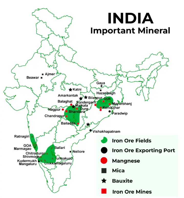
Urbanization in India has been a significant trend over the past few decades, driven by rapid economic growth, industrialization, and migration from rural areas to cities. According to the Census 2011, over 31% of India’s population lives in urban areas, and this number is expected to rise to nearly 40% by 2030. This shift is primarily due to the growing industrial sector, employment opportunities, and better access to healthcare, education, and infrastructure in urban centers.
The trend of urbanization is most prominent in states like Maharashtra, Uttar Pradesh, Tamil Nadu, and Gujarat, where cities such as Mumbai, Delhi, Chennai, and Ahmedabad have witnessed rapid growth. Additionally, Tier-2 cities like Pune, Indore, Coimbatore, and Vadodara have also seen substantial urban expansion due to better connectivity, industrial development, and improved living standards.
The migration from rural areas to urban centers is a key driver of urbanization. Factors such as agricultural distress, lack of employment opportunities in rural areas, and better prospects in cities have led to a rise in the rural-to-urban migration. This influx of population often leads to challenges like overcrowding, slum development, inadequate housing, traffic congestion, and increased pollution.
The government has implemented initiatives like the Smart Cities Mission, Atal Mission for Rejuvenation and Urban Transformation (AMRUT), and Pradhan Mantri Awas Yojana (PMAY) to address the challenges of urbanization, focusing on sustainable development, affordable housing, and urban infrastructure.
In the coming years, urbanization in India will continue to be a key driver of economic development, although it will require a concerted effort to balance growth with environmental sustainability and social inclusion.
The Ganga River System: The Ganga Originates from the Himalayan mountains and is super important for the people there. The melting snow from the Himalayas forms the basis of the river Ganga. Ganga flows through various states of India, covering some parts of Delhi, Madhya Pradesh, Uttar Pradesh, Rajasthan, West Bengal, Bihar, Jharkhand, Himachal Pradesh, Chattisgarh, and Haryana.
Overview of Ganga River System
| Aspect | Details |
|---|---|
| Source | Gangotri Glacier, Uttarakhand |
| Length | Approximately 2,525 km (1,569 miles) |
| Drainage Area | About 1,086,000 sq km (419,300 sq miles) |
| Main Tributaries | Left Bank: Ramganga, Gomti, Ghaghara, Gandak, Kosi Right Bank: Yamuna, Son |
| Major Cities | Haridwar, Kanpur, Allahabad (Prayagraj), Varanasi, Patna |
| Dams and Barrages | Tehri Dam, Farakka Barrage, Narora Barrage, Kanpur Barrage |
| Flora and Fauna | Home to the Ganges River Dolphin, Gharial, Freshwater turtles, and numerous fish and bird species |
| Cultural Significance | Considered sacred by Hindus; site of numerous religious ceremonies and festivals |
| Environmental Challenges | Pollution from industrial, agricultural, and domestic sources; riverbank erosion; habitat destruction |
Ganga River System Map
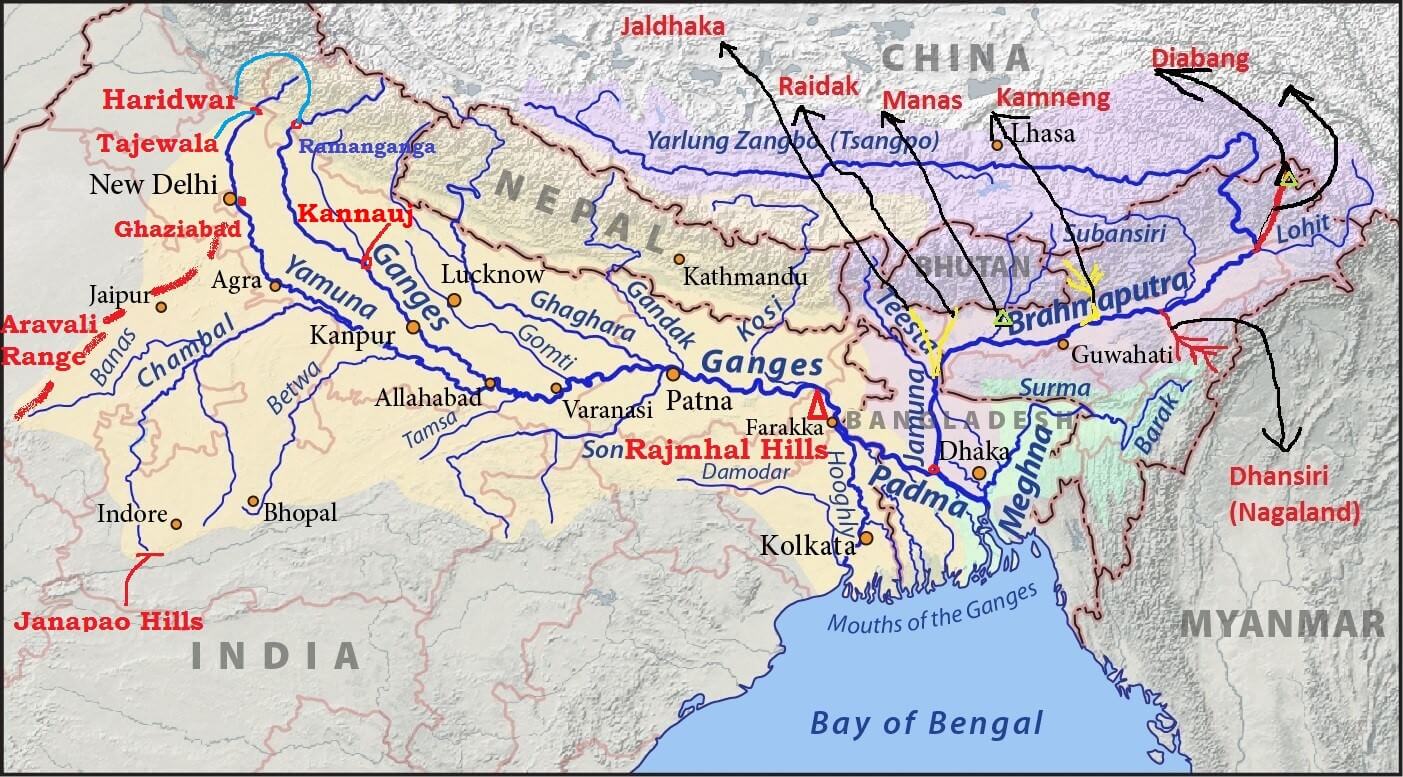
The Ganga River System
The Ganga River system is enormous worldwide and covers most of India. The soil near the Ganga River is fertile, helpful in agriculture, and supports big industries.
- The River Ganga represents the dendritic drainage pattern.
- The Ganga River is the home to many plants and animals.
- Most employment in India comes from the banks of the river Ganga.
- The largest delta was created when the river Ganga and the Brahmaputra met and is called the Sundarbans delta.
- Ganga flows south and east from the Himalayas, forming the canyon as it leaves the mountains.
What is the Ganga Drainage System?
The Ganga Drainage System includes the river Ganga and its many tributaries. It is one of the iconic and largest river systems in the world, extending over India, Bangladesh, and the boundaries of Nepal. Ganga River drains into the Bay of Bengal through the Sundarban Delta.
Bhagirathi
The Bhaigirathi river covers a big part of the River Ganga. The best features of it are listed below:
- In the 16th Century, when the Ganga river shifted its bed eastwards, Bhagirathi came into existence.
- The Bhagirathi covers upto 193 kilometres and then joins the Alaknanda in Devprayag.
- It covers an area upto 6,921 kilometers.
- Many other rivers add water to Bhagirathi, namely Kedar Ganga and Kakora Gad.
- Other Rivers that add water to Bhagirathi include Jalandhari Gad, Jadh Ganga, Asi Ganga, Siyan Gad, and Bhilangana river.
Alaknanda
The Alaknanda River originates when the two glaciers meet in Uttrakhand.
The following are the key features of the Alaknanada River:
- It travels upto 195 kilometres and joins Bhagirathi at Devprayag.
- The river covers an area upto 10,882 kilometers.
- When the river joins Bhagirathi at Devprayag, they become the Ganges river together.
- In Uttrakhand, there are five meeting points where the rivers join Alaknanada called the Panch Prayags.
- Saraswati, Pindar, Dhauliganga, and Nandini are the rivers that join from the left and the Mandakini River from the right.
Rishiganga
The Rishiganga originates from the Nanda Devi Mountains, located in Uttrakhand, and goes through a national park where it meets Dhaulganga West at Raini near Chamoli.
Dhauliganga
The Dhauliganga rises from the largest glacier, Raikana Glacier, Basudhara Lake in Uttrakhand. This Lake is way up in the mountains at 5,070 meters near Niti Pass in Chamoli district. As it flows down, many other rivers join it, finally meeting the river Alaknanda at the village called Vishnuprayag.
Tributaries of the Ganga River
Many streams join the river Ganga in different locations in different parts of India, called the tributaries of the river Ganga. They are further divided into the right bank and the left bank tributaries.
Right Bank Tributaries of River Ganga
The following table gives information about the right bank tributaries of the River Ganga:
Name of Right Tributaries | Description |
|---|---|
Yamuna |
|
Karmanasa |
|
Punpun |
|
Son |
|
Damodar River |
|
Falgu |
|
Kiul |
|
Chandan |
|
Ajay |
|
Rupnarayan |
|
Tamsa |
|
Left Bank Tributaries of River Ganga
The following table gives information about the left bank tributaries of the River Ganga:
Ramganga |
|
|---|---|
Gomati River |
|
Ghargra River |
|
Kosi River |
|
Mahananda River |
|
Burhi Gandak River |
|
Gandak River |
|
The Green Revolution was a period that began in the 1960s during which agriculture in India was converted into a modern industrial system by the adoption of technology, such as the use of high yielding variety (HYV) seeds, mechanized farm tools, irrigation facilities, pesticides, and fertilizers. Mainly led by agricultural scientist M. S. Swaminathan in India, this period was part of the larger Green Revolution endeavor initiated by Norman Borlaug, which leveraged agricultural research and technology to increase agricultural productivity in the developing world. Varieties or strains of crops can be selected by breeding for various useful characteristics such as disease resistance, response to fertilizers, product quality and high yields.
Under the premiership of Congress leaders Lal Bahadur Shastri and Indira Gandhi, the Green Revolution within India commenced in 1968, leading to an increase in food grain production, especially in Punjab, Haryana, and Western Uttar Pradesh. Major milestones in this undertaking were the development of high-yielding varieties of wheat, and rust resistant strains of wheat
Due to its diverse geological structure, India is endowed with a diverse range of mineral resources. After Zimbabwe, India processes the world’s second-largest manganese reserves. After China, Gabon, South Africa, and Australia, India is the world’s fifth-largest producer. The major manganese ore-producing states are Maharashtra, Madhya Pradesh, Odisha, Andhra Pradesh, and Karnataka. More than half of India’s manganese is produced in Maharashtra and Madhya Pradesh combined.
Manganese Resources in India
- Manganese ore deposits in India are primarily associated with the Gondite Series of Madhya Pradesh (Balaghat, Chhindwara & Jhabua districts), Maharashtra (Bhandara & Nagpur districts), Gujarat (Panchmahal district), Odisha (Sundargarh district), and Andhra Pradesh (Ganjam & Koraput districts) and the Kodurite Series (Archaeans) (Srikakulam & Visakhapatnam districts).
- Opencast and underground methods of manganese ore mining are both used in the country.
- There are 8 underground mines out of 142 total (3 in Madhya Pradesh and 5 in Maharashtra).
- MOIL Ltd, a public sector company, operated seven underground mines, while M/s J.K. Minerals, Balaghat (Madhya Pradesh), a private company, operated one.
- The underground mines are all mechanized or semi-automated.
Importance of Manganese
- Manganese is a silvery grey mineral that is extremely hard and brittle.
- It is always found in the presence of iron, laterite, and other minerals.
- Manganese in alloy form is a critical component of steel production, and steel is one of the most important indicators of a country’s industrial economy’s growth.
- Manganese ore trade volume has increased globally, including in India, in recent years.
- India is currently one of the world’s largest importers of manganese ore.
Transportation of Manganese Ore in India
- Manganese ore is typically transported by trucks from mines to railheads, where it is then transported to ports by rail wagons.
- The ore is transported by aerial ropeways from the MOIL mine in Balaghat district, Madhya Pradesh, to the rail-head loading bins.
- In Goa, the ore is transported in bulk via road-to-river routes up to Mormugao harbor, and in a few cases, by rail where mines are close to railways.
- The ore loading into barges at the river’s mouth is done mechanically.
State Wise Distribution of Manganese
| State | Percentage of Production |
|---|---|
| Maharashtra |
|
| Madhya Pradesh |
|
| Odisha |
|
| Andhra Pradesh |
|
| Karnataka |
|
| Other Producers |
|
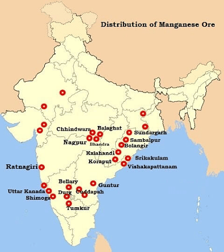
Exports
- Over four-fifths of total production is consumed domestically, with only one-fifth exported.
- The manganese exports have been steadily declining due to rapidly rising demand in the domestic market.
- This is due to the expansion of some of the industries that rely on manganese as a primary raw material.
Worldwide Supply of and Demand for Manganese
- Only four countries produced 70% of the world’s manganese ore in 2011, in decreasing order of production: South Africa, Australia, China, and Gabon.
- These four countries, plus Brazil and Ukraine, account for 90% of proven manganese reserves.
- The United States, like many other industrialized countries, particularly in Europe, has no manganese reserves.
- In the United States, all manganese ore is imported. Gabon (61%) was the primary source of ore from 2008 to 2011, followed by Australia (21%), South Africa (7%), and Brazil (5 percent).
- Manganese demand has historically tracked steel production and is expected to do so again in the future.
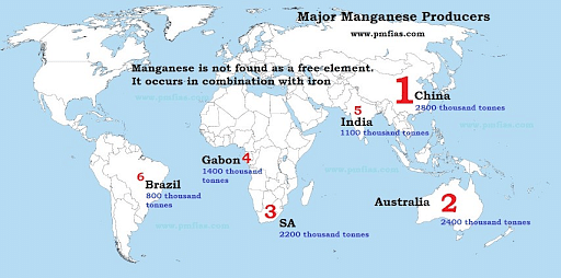
The sugar industry in India is one of the oldest and largest agro-based industries, playing a significant role in the country’s economy. India is the second-largest producer of sugar in the world, after Brazil, and the largest consumer of sugar globally. The industry is primarily based on the cultivation of sugarcane, which is grown in states like Uttar Pradesh, Maharashtra, Karnataka, Tamil Nadu, and Andhra Pradesh. Uttar Pradesh and Maharashtra are the leading sugar-producing states, contributing nearly 60% of India’s total sugar production.
The Indian sugar industry is composed of both private and co-operative mills. Sugar mills are concentrated in the regions where sugarcane farming is prominent. These mills not only produce sugar but also generate by-products like molasses, bagasse, and ethanol. Molasses is used in the production of alcohol and ethanol, which is an important part of the country’s biofuel industry. Bagasse, a fibrous residue left after sugar extraction, is used as a fuel in sugar mills or converted into paper and biomass energy.
The Indian government plays a significant role in regulating the sugar industry through policies on minimum support price (MSP) for sugarcane, export/import restrictions, and subsidies to promote domestic production. Despite these efforts, the industry faces challenges such as fluctuating sugar prices, water scarcity, high input costs, and issues of overproduction. The industry is also under pressure to become more sustainable, given the environmental impact of sugarcane farming and water usage.
The future of the sugar industry in India depends on improving productivity, diversifying production, and promoting export to stabilize the market and meet global demand.
The Thar Desert, also known as the Great Indian Desert, is located in the northwestern part of India, primarily in the states of Rajasthan, along with parts of Punjab, Haryana, and Gujarat, extending into Pakistan. Covering an area of about 200,000 square kilometers, it is the world’s 17th largest desert and one of the most densely populated deserts globally.
The Thar Desert is characterized by its arid climate, receiving very little rainfall, averaging around 100 to 500 mm annually, making it one of the driest regions in India. The desert experiences extreme temperature variations, with scorching summer temperatures reaching up to 50°C and cold winters with temperatures dropping to 0°C. The sand dunes, which are a dominant feature of the desert, are constantly shifting due to the strong winds, creating a dynamic and ever-changing landscape.
Despite its harsh conditions, the Thar Desert is home to a variety of flora and fauna. Vegetation is sparse but includes cactus, acacia, and xerophyte plants that are well adapted to dry conditions. The desert is also home to several species of animals, including the Indian wild ass, desert fox, chinkara, and a variety of reptiles. The region has rich biodiversity, though many species are endangered due to habitat loss and overexploitation of resources.
The desert supports agriculture, particularly millets, barley, and wheat, which are grown in irrigated regions using canal systems from the Indira Gandhi Canal. The Thar Desert also has a growing tourism industry, with attractions like Jaisalmer, Sam Sand Dunes, and the Kuldhara village drawing visitors. However, water scarcity, desertification, and climate change pose significant challenges to sustainable development in the region.
Black soil, also known as Regur soil, is one of the most fertile soils in India, primarily found in the Deccan Plateau, covering large parts of Maharashtra, Madhya Pradesh, Chhattisgarh, Karnataka, Andhra Pradesh, and Tamil Nadu. It is rich in lime, iron, magnesium, and aluminum, with a high content of blackish clay, which is the result of weathered basalt rocks. These soils are also known for their ability to retain moisture, making them ideal for dryland farming.
The black soil has a distinctive dark color, which is due to the presence of humus and organic matter. It is highly moisture-retentive, especially during the monsoon season, and forms a cracked surface in dry conditions. The high calcium carbonate content gives the soil a slightly alkaline nature. It is particularly rich in potassium, which is beneficial for growing cotton, groundnut, soybean, and chili — crops that thrive in these soils.
Black soil is also highly fertile and supports extensive agriculture. It is well-suited for the cultivation of cash crops like cotton, often referred to as the “black cotton soil” due to its association with cotton farming. It is also used for growing soybeans, maize, pulses, and groundnuts. The soil’s high moisture retention and fertility make it an ideal medium for these crops, which are crucial to India’s agricultural economy.
However, black soils can face challenges like salinization and alkalinity in areas where irrigation is poorly managed. Additionally, erosion and waterlogging can affect soil health, requiring careful management practices to maintain its productivity.
The word ‘petroleum’ has been derived from two Latin words Petra (meaning rock) and Oleum (meaning oil). Thus petroleum is oil obtained from rocks; particularly sedimentary rocks of the earth. Therefore, it is also called mineral oil.
Technically speaking, petroleum is an inflammable liquid that is composed of hydrocarbons which constitute 90 to 95 per cent of petroleum and the remaining is chiefly organic compounds containing oxygen, nitrogen, sulphur and traces of organo-metallic compounds.
Mineral oil (petroleum) in India is primarily found in the northwestern, eastern, and southern regions, with significant oil fields in Assam, Gujarat, Rajasthan, and offshore areas like the Mumbai High field in the Arabian Sea. The country’s petroleum reserves are not very large compared to global producers, but they play a crucial role in meeting domestic energy demands.
The Assam region, particularly around Digboi, is one of the oldest oil-producing areas in India, with reserves located in the Upper Assam Basin. This region has been historically significant in the development of India’s oil industry. The Gujarat state is another important area, with large reserves in fields like Ankleshwar and Mehsana, where both onshore and offshore drilling is prevalent. Rajasthan also contributes to the country’s petroleum production, especially from the Barmer Basin, which has rich reserves discovered in recent decades.
Offshore fields, particularly the Mumbai High field, which is situated in the Arabian Sea, contribute significantly to India’s petroleum production. Mumbai High is one of the largest offshore oil fields in the country and is operated by ONGC (Oil and Natural Gas Corporation). Other offshore areas, such as the Cauvery Basin off the coast of Tamil Nadu and Krishna-Godavari Basin in Andhra Pradesh, are emerging as important sources of petroleum.
India’s total crude oil production meets only about 30% of its domestic requirements, with the remaining demand being met through imports. The country has been focusing on increasing exploration in offshore areas and enhancing petroleum refining capacity to reduce dependency on imports.
Industrial localization in India refers to the concentration of specific industries in particular regions, driven by a combination of natural resources, economic factors, infrastructure, and government policies. Various factors influence industrial localization across the country, contributing to the development of specific industrial hubs.
One of the primary factors is the availability of raw materials. Industries such as iron and steel, cement, and textiles are often located near sources of essential raw materials. For instance, the iron and steel industry is heavily concentrated in areas like Jamshedpur (Jharkhand), Bokaro, and Rourkela, where iron ore, coal, and other minerals are readily available.
Another key factor is transportation and accessibility. Proximity to ports, railways, and roads is vital for industries dependent on the movement of goods, such as automobiles and electronics. Mumbai, for example, serves as a hub for the petrochemical industry due to its accessibility to both crude oil imports and a developed port system.
Labor availability and skilled workforce also play a critical role in industrial localization. Regions with a high population of skilled labor, such as Gurgaon and Bengaluru, are favorable for industries like information technology and electronics. Additionally, government policies like tax incentives, subsidies, and the establishment of industrial zones encourage businesses to set up in specific areas. Special Economic Zones (SEZs) in states like Maharashtra, Gujarat, and Tamil Nadu have attracted both domestic and foreign investment.
Lastly, the presence of market demand and consumer bases significantly influences industrial concentration. Delhi, for example, is an industrial hub due to its proximity to both a large consumer market and a highly developed infrastructure.
These factors combine to determine the regional distribution of industries across India, fostering economic growth in certain areas while contributing to regional imbalances in industrial development.
India is one of the largest producers of coal in the world, with significant coal reserves spread across various states. The major coal-producing areas in India are primarily located in the eastern and central regions, where vast coal deposits are found.
The Jharia Coalfields in Jharkhand are among the oldest and most significant coalfields in India. Jharia produces high-quality coking coal, which is essential for the steel industry. Other important coalfields in Jharkhand include Bokaro, Giridih, and Karanpura, which contribute to the region’s high output.
In Chhattisgarh, the Korba coalfield is one of the largest and most productive in India. The coal from Korba is mainly used for power generation in the region. Raigarh and Hasdeo Arand coalfields also contribute significantly to the state’s coal production.
Odisha is another major coal-producing state, with coalfields like Talcher and Ib Valley. The Talcher coalfields are rich in thermal coal, which is largely used in the power sector. Odisha has the advantage of being close to the ports, facilitating easy export of coal.
In Madhya Pradesh, the Singaruli coalfields are an important source of both coking and thermal coal. This area supplies coal to industries and thermal power plants in the region.
West Bengal houses the Raniganj Coalfields, which are known for their high-quality coal and are a significant source of both coking and thermal coal. Other coalfields in the region include Sodepur and Barjora.
Apart from these, Uttar Pradesh and Andhra Pradesh also contribute to India’s coal production, with coalfields like Singrauli and Chilika. The overall coal production in India is vital for meeting the country’s energy demands, as coal remains the dominant source of fuel for thermal power generation.
The sugar industry in North Eastern Uttar Pradesh is an important part of the region’s economy, with the area contributing significantly to the state’s total sugar production. This region includes districts such as Gorakhpur, Basti, Deoria, Mau, and Azamgarh, where sugarcane is a major cash crop. The favorable climatic conditions, including adequate rainfall and a warm climate, support the cultivation of sugarcane, making it suitable for sugar production.
The industry in this region is primarily based on cooperative sugar mills and private mills, which are spread across the districts. The presence of these mills supports local employment and generates revenue for the farmers who cultivate sugarcane. North Eastern Uttar Pradesh is known for producing medium-quality sugar, which is primarily used for domestic consumption and industrial use.
One of the key advantages of the sugar industry in this region is its proximity to the markets in eastern Uttar Pradesh and neighboring Bihar and West Bengal. This ensures easy distribution and market access for the sugar produced. The industry also contributes to the production of by-products such as molasses (used in alcohol production) and bagasse (which is used as fuel for mills or in the production of paper).
However, the region faces certain challenges, including irrigation issues, low productivity of sugarcane, and the seasonality of sugar production. The industry has been affected by fluctuations in sugarcane prices and the financial viability of mills. Despite these challenges, the sugar industry in North Eastern Uttar Pradesh plays a crucial role in the regional economy by supporting agriculture, employment, and rural development.
Soil erosion is a significant environmental problem in India, affecting agricultural productivity, ecosystem stability, and rural livelihoods. It occurs primarily due to deforestation, overgrazing, uncontrolled farming, and heavy rainfall in certain regions. Areas with steep slopes, such as the Himalayan foothills, Western Ghats, and parts of the Deccan Plateau, are particularly vulnerable to soil erosion.
The Himalayan region experiences severe erosion due to the combined effect of intensive farming, overgrazing, and deforestation. Monsoon rains further exacerbate the problem, leading to landslides and loss of topsoil. Similarly, regions like Madhya Pradesh, Chhattisgarh, and Odisha, where slash-and-burn farming (or shifting cultivation) is practiced, face soil erosion due to the destruction of forest cover and lack of proper soil conservation methods.
Water erosion is particularly prevalent in regions with intensive agriculture, where improper irrigation methods and overuse of water resources lead to the washing away of topsoil. The coastal areas, especially in Gujarat and Maharashtra, are also prone to erosion due to the combination of sea waves, human activity, and climatic changes.
The consequences of soil erosion are far-reaching: reduced soil fertility, increased flooding, loss of biodiversity, and the desertification of agricultural lands. In response, the government and various environmental agencies have implemented soil conservation programs, including the construction of check dams, terracing, and the use of cover crops to control erosion. The promotion of sustainable agricultural practices and afforestation also plays a crucial role in mitigating the problem. Despite these efforts, soil erosion remains a major environmental challenge in India, particularly in hill regions and drought-prone areas.
Canal irrigation plays a crucial role in the agricultural economy of Northern India, where large areas of land are dependent on irrigation for crop production, particularly in states like Punjab, Haryana, Uttar Pradesh, and Rajasthan. The availability of water through canals has significantly boosted agricultural productivity in these regions, supporting the growth of crops such as wheat, rice, sugarcane, and cotton.
The Indira Gandhi Canal, one of the most significant irrigation systems in the region, provides water to parts of Rajasthan, transforming the arid desert areas of Thar Desert into cultivable land. This canal has been a game-changer for agriculture in Rajasthan, supporting the cultivation of wheat, barley, cotton, and oilseeds. Similarly, the Sutlej-Yamuna Link Canal in Punjab and Haryana provides water to large agricultural areas, enhancing crop yield and ensuring food security in the region.
In Uttar Pradesh, the Ganga Canal system irrigates vast stretches of land, primarily in the Doab region (between the Ganges and Yamuna rivers), which is one of the most fertile regions in India. The upper Ganga canal is vital for irrigation, ensuring a reliable supply of water for crops during dry periods.
However, canal irrigation in Northern India faces several challenges. Waterlogging, salinization, and the mismanagement of water resources in some areas have led to a decline in soil fertility. Inadequate maintenance of canal systems and increasing water demand due to population growth and industrialization also pose significant concerns. Despite these challenges, canal irrigation remains a cornerstone of agricultural productivity and economic development in Northern India.
Multi-level planning in India refers to the system of planning that involves various levels of government, including the national, state, and local levels, with each playing a role in the formulation, implementation, and monitoring of plans. This approach aims to address the diverse needs of different regions and communities while promoting inclusive development and decentralized governance.
At the national level, the Planning Commission (now replaced by the NITI Aayog) formulates broad national plans, such as the Five-Year Plans, which focus on overall economic growth, infrastructure development, and poverty alleviation. These plans set the direction for development policies and allocate resources for various sectors across the country.
The state level plays a vital role in implementing national plans by tailoring them to local needs, taking into account regional disparities in terms of resources, infrastructure, and human development indicators. Each state government formulates its own State Plans based on the broad guidelines provided at the national level, focusing on key sectors like agriculture, education, health, and industry.
At the local level, panchayats (rural local bodies) and municipalities (urban local bodies) are responsible for implementing development programs directly at the grassroots. Through the 12th Schedule of the Indian Constitution, local bodies are empowered to plan and manage sectors such as healthcare, education, water supply, and rural development. This bottom-up approach ensures that local issues are addressed and that the benefits of development reach the most marginalized sections of society.
Multi-level planning fosters coordinated development across regions, minimizes regional imbalances, and enhances the effectiveness of public policies by integrating different levels of government in the planning process. It has helped in achieving inclusive growth by ensuring that both urban and rural areas contribute to and benefit from economic development.
Floods are a recurring natural disaster in India, affecting millions of people and causing widespread damage to life, property, and infrastructure. The country experiences floods primarily due to monsoon rains, river overflow, and poor drainage systems in urban and rural areas. The Himalayan rivers, such as the Ganga, Brahmaputra, and Indus, along with their tributaries, are prone to flooding, especially during the southwest monsoon from June to September.
The Brahmaputra river and its tributaries in the northeastern states of Assam, Arunachal Pradesh, and West Bengal often experience catastrophic floods due to the combination of intense rainfall, snowmelt from the mountains, and the river’s low gradient. Similarly, states like Uttar Pradesh, Bihar, and Odisha suffer from frequent flooding during the monsoon season, primarily due to the overflow of rivers like the Ganga, Yamuna, and Mahanadi.
Urban floods have also become more common due to poor urban planning, encroachment on floodplains, and the blockage of drainage systems in cities like Mumbai, Chennai, and Kolkata. In these cities, heavy rainfall, combined with inadequate infrastructure, leads to waterlogging and severe flooding, causing disruptions in daily life.
The causes of floods in India are further exacerbated by deforestation, climate change, and the degradation of natural wetlands, which reduce the land’s ability to absorb excess water. In response, the government has implemented flood control measures, including the construction of dams, embankments, and flood forecasting systems. Despite these efforts, floods continue to pose a significant challenge to the country, highlighting the need for improved disaster management, floodplain zoning, and sustainable development practices.
Soil conservation is the practice of preventing soil erosion, degradation, and maintaining soil health for sustainable agricultural productivity. In India, soil erosion due to factors such as deforestation, overgrazing, intensive farming, and monsoon rainfall has resulted in significant soil loss, reducing soil fertility and increasing the risk of desertification. To combat these issues, several soil conservation techniques have been implemented across the country.
One of the most common methods is terracing, especially in hilly and mountainous regions like the Himalayas and the Western Ghats, where land is shaped into steps to slow down water runoff. Another important method is the construction of check dams and water-harvesting structures, which help store water and reduce surface runoff, allowing water to seep into the ground. This is particularly effective in arid and semi-arid regions like Rajasthan and Madhya Pradesh.
Agroforestry and afforestation are also crucial in preventing soil erosion. Planting trees alongside crops helps anchor the soil, prevent wind erosion, and add organic matter to the soil. Cover crops like legumes are planted to protect the soil from direct rainfall and improve its fertility by fixing nitrogen.
In areas prone to wind erosion, particularly in Rajasthan, methods like windbreaks (planting rows of trees to reduce wind speed) and mulching are used. Gully plugging and contour bundling are other techniques used in regions with significant water erosion to prevent soil loss.
The government has supported soil conservation programs under schemes like the National Watershed Development Project to promote sustainable agricultural practices, improve soil health, and enhance water availability. Proper implementation of these methods is crucial for improving agricultural productivity and ensuring long-term environmental sustainability in India.