
A political region is an area defined by specific political characteristics, such as a governmental structure, administrative boundaries, or jurisdiction. These regions are often established by laws, treaties, or historical agreements and can vary in size and governance. Examples include countries, states, provinces, counties, and municipalities.
Political regions are created to organize people and resources, enabling efficient governance, law enforcement, and resource management. They often reflect shared cultural, economic, or historical identities but may also be drawn for purely administrative purposes. Boundaries can sometimes be sources of conflict if they do not align with ethnic or cultural divisions.
These regions are crucial for implementing policies, taxation, and public services. For instance, within a country, political regions like states or provinces often have autonomy over certain matters, such as education or transportation, while remaining subordinate to the central government.
The concept highlights the interplay between geography and politics, illustrating how spatial organization impacts political authority and societal functions.
Desert vegetation refers to the types of plants that grow in arid and semi-arid regions with low rainfall, extreme temperatures, and poor soil conditions. These plants are specially adapted to survive in harsh environments with scarce water.
Key characteristics of desert vegetation include xerophytic adaptations, such as thick waxy leaves to reduce water loss, deep or widespread roots to access groundwater, and the ability to store water in stems or leaves, as seen in succulents like cacti. Many desert plants, such as acacia, prickly pear, and yucca, have small or spiny leaves to minimize transpiration and deter herbivores.
In deserts, vegetation is often sparse and clustered around oases, riverbeds, or areas with underground water. Some plants, like ephemerals, grow quickly after rainfall, completing their life cycle within weeks. Others, like sagebrush and mesquite, can tolerate saline soils and high temperatures.
Desert vegetation plays an essential role in stabilizing the soil, preventing erosion, and supporting desert ecosystems by providing shelter and food for animals adapted to these environments. This vegetation is a testament to nature’s resilience in adapting to extreme conditions.
In physical geography, tundra is a type of biome where tree growth is hindered by frigid temperatures and short growing seasons. There are three regions and associated types of tundra: Arctic tundra, alpine tundra, and Antarctic tundra.
Tundra vegetation is composed of dwarf shrubs, sedges, grasses, mosses, and lichens. Scattered trees grow in some tundra regions. The ecotone (or ecological boundary region) between the tundra and the forest is known as the tree line or timberline. The tundra soil is rich in nitrogen and phosphorus. The soil also contains large amounts of biomass and decomposed biomass that has been stored as methane and carbon dioxide in the permafrost, making the tundra soil a carbon sink. As global warming heats the ecosystem and causes soil thawing, the permafrost carbon cycle accelerates and releases much of these soil-contained greenhouse gases into the atmosphere, creating a feedback cycle that changes climate.
The Arctic Ocean drainage system refers to the network of rivers, streams, and other water bodies that flow into the Arctic Ocean. Covering vast northern regions, it includes parts of Canada, Russia, Scandinavia, and Alaska. This drainage basin is crucial for regulating the hydrological cycle in the Arctic and supporting its unique ecosystems.
Major rivers draining into the Arctic Ocean include the Ob, Yenisei, and Lena in Russia, along with the Mackenzie River in Canada. These rivers carry large volumes of freshwater, which mix with the saline Arctic waters, influencing the ocean’s salinity and circulation patterns. The influx of freshwater impacts sea ice formation and contributes to the overall climate regulation of the region.
The Arctic Ocean drainage area also includes extensive wetlands, lakes, and permafrost regions, which act as reservoirs for carbon and methane. Melting permafrost due to climate change is increasing the freshwater flow, disrupting natural processes, and affecting global sea levels and ecosystems.
This system is vital for Arctic communities, providing resources like fishing, transportation, and cultural significance while playing a critical role in the Earth’s environmental balance.
- Temperature: Moderate temperatures with little extreme variation, typically averaging between 5°C and 15°C throughout the year.
- Precipitation: Adequate rainfall distributed fairly evenly throughout the year, with slightly higher amounts during winter.
- Seasons: Four distinct seasons, with mild winters and cool summers.
- Cloud Cover: Frequent cloud cover, often with fog and mist, especially during winter.
- Wind Patterns: Dominated by westerly winds bringing in moist air from the Atlantic Ocean.
Podzolic soil, also termed as podzol, or called the lessive soil, is a soil that is usually formed in a broadleaf forest and is mostly characterised by the average leaching, which is also highly susceptible to compaction.
The eluvium horizon is usually 4 cm to 8 cm thick, and is low in iron and aluminium oxides and humus. It is generally formed under moist, cool, and acidic conditions, and only where the parent material, like the granite or the sandstone, is present and is rich in quartz. It is usually found under a huge layer of organic material during the process of decomposition, which has a thickness of 5 cm to 10 cm. Sometimes, the middle region often has a thin horizon of 0.5 cm to 1 cm. When the soil horizon gets bleached, it goes over into another red or red-brown horizon, which is also known as the so-called Podzolic B. The colour is normally strongest in the upper region, and the changes occur at a depth of 50 cm to 100 cm, and it progresses to the part where the soil is mainly unaffected by any of the processes, which is the part of the parent material. The solid profiles are named by the letters A, which is the topsoil, E, which is the eluviated soil, B, which is the subsoil, and C, which is the parent material. The red yellow podzolic soil is a poor soil with many limitations, including low soil pH, low clay content, low aggregate stability, low nutrient content, and susceptibility to compaction. Organic matter is the only indicator of fertility in these soils.
In some of the Podzols, the E horizon is absent, which can be because of being masked by the biological activity or being obliterated by the disturbance. The podzols that have very little or almost no E horizon development are often classified as the brown podzolic soils, which are also called Umbrisols and Umbrepts.
Podzolization Process
The process of podzolization is a complex soil formation process due to which the organic matter is dissolved and ions of iron and aluminium are released through the weathering of various minerals from the organo-mineral complexes, and are moved from the upper parts of the soil profile. It goes and deposits in the deeper regions of the soil. Via this process, the eluvial horizon of the podzol becomes bleached and it turns into an ash-grey colour. The complexes move along with the percolating water and move further down to the illuviated horizons, which are usually brown or are coloured red or black when they accumulate, and are made up of cemented sesquidoxes and/or organic compounds. Thus, podzolization is typically a soil formation process in the podzols.
The above-mentioned process of formation of podzol soil, known as podzolization, can be simplified into two main steps:
- The mobilisation and the translocation of the organic matter, iron and aluminium, from the surface horizon
- The immobilisation and the stabilisation of the organic matter, the iron and aluminium, into the subsoil
Finally, podzolization also promotes the relocation of some of the nutrients, such as copper, iron, manganese, molybdenum, and phosphorus, bringing them closer to the plant roots.
Podzolization
Process of soil formation results in the formation of Podzols and Podzolic soils. Podzolization consists of the downward migration of Al and Fe elements. It happens together with organic matter, from the surface areas, and their accumulation in the profile’s deep areas. The bases, other than Calcium, are generally removed and the whole soil becomes very acidic (which implies acid leaching). This process is characterised generally by a strong acidity that causes slow organic development. It releases acidic nature compounds and so the extreme alteration of the mineral phase takes place, because the medium is enriched with insoluble elements, such as Fe and Al. So they are generally migrated towards lower portions by the organic compounds.
A favourable combination of environments of podzolization include the following:
i) Ideal climatic conditions: The humid and cold climatic conditions are ideal for it.
ii) Parent material: Sandy materials have poor reserves of weatherable minerals. Hence, they generally favour the operation of podzolization because it helps in easy percolation of water.
iii) Acid Product Vegetation: Acid-producing vegetation such as coniferous pines are essential.
iv) Leaching and Translocation of Sesquioxide: Due to becoming mobile of hummus and Sesquioxide, they leach out from the upper horizon and deposit in the lower one.
As iron and aluminium move about, the horizon gives a bleached grey and ashy appearance. The Russians used the term Podzols (pod means under, and the meaning of Zola is ash-like, i.e., ash-like horizon appearing beneath the surface horizon) for such soils.
The United States of America (USA) is located in the Northern Hemisphere, primarily in North America, between Canada to the north and Mexico to the south. It is bordered by the Atlantic Ocean on the east and the Pacific Ocean on the west. The USA’s location makes it a major hub for global trade and cultural exchange.
The country spans a wide geographical extent, covering approximately 9.8 million square kilometers. It lies between 24°N to 49°N latitude and 67°W to 125°W longitude, not including Alaska and Hawaii. Alaska extends further north and west, while Hawaii is located in the central Pacific Ocean.
The USA consists of 50 states, including the contiguous 48 states, plus Alaska and Hawaii. Its vast size and diverse geography include mountains (e.g., the Rockies and Appalachians), plains, deserts, and coastal regions.
With its strategic position between two major oceans, the USA has significant economic and military importance. Its geographic diversity contributes to a range of climates and ecosystems, from tundra in Alaska to tropical rainforests in Hawaii, making it one of the most geographically varied nations in the world.
The New England Industrial Region is one of the earliest and most historically significant industrial regions in the United States, located in the northeastern part of the country. It includes the states of Massachusetts, Connecticut, Rhode Island, New Hampshire, Vermont, and Maine. This region played a pivotal role in the Industrial Revolution in the U.S. during the late 18th and early 19th centuries.
The region’s industrial development was driven by factors such as an abundance of rivers and streams providing waterpower, a well-educated labor force, and proximity to Atlantic trade routes. The New England Industrial Region became known for its textile mills, machinery manufacturing, shipbuilding, and later, electronics and high-tech industries.
Major cities like Boston, Providence, and Hartford became hubs for industrial activity and innovation. The region also benefited from investments in infrastructure, such as railroads and ports, facilitating trade and transportation.
Although traditional manufacturing declined in the 20th century, New England remains a significant center for education, technology, and finance, with industries like biotechnology and advanced manufacturing emerging in recent years. Its industrial legacy continues to influence its economy and culture.
Formal regions, often referred to as ‘uniform regions,’ are defined by a common physical or cultural attribute present throughout the region. They showcase a degree of homogeneity in one or more phenomena that distinguish them from surrounding areas.
For instance, political entities like countries, states, and cities fall under formal regions due to shared governance. Other examples include areas characterized by specific climate types, soil types, or language spoken.
Key characteristics of formal regions include:
- Clear and distinct boundaries
- Shared cultural or physical characteristics
- Examples: Sahara Desert (physical), Francophone Africa (cultural)
Cultural regions refer to areas of the world where people share similar cultural characteristics such as language, customs, beliefs, and traditions. Understanding cultural regions is essential in developing a comprehensive understanding of human diversity and the ways in which cultures have shaped societies and influenced their development over time.
Meaning and History of Cultural Regions
Cultural regions are areas of the world where people share similar cultural characteristics such as language, customs, beliefs, and traditions. These characteristics can include everything from shared religious practices to food and clothing.
Cultural regions have been recognized and studied for centuries, with early explorers and travelers documenting the unique characteristics of different cultures they encountered. In the early 20th century, cultural regions became an important focus of study for anthropologists, who sought to understand the diversity of human cultures and the ways in which they shape societies.
Types of Cultural Regions
- Linguistic Regions: Linguistic regions are areas of the world where people share a common language or language family. Examples of linguistic regions include the Romance-speaking regions of Europe, which include countries such as France, Spain, and Italy, and the Mandarin-speaking regions of China.
- Religious Regions: Religious regions are areas of the world where people share a common religion or set of religious beliefs. Examples of religious regions include the Islamic world, which includes countries such as Saudi Arabia, Iran, and Indonesia, and the Christian world, which includes countries such as the United States, Brazil, and Italy.
- Geographical Regions: Geographical regions are areas of the world that share similar physical characteristics such as climate, topography, and vegetation. Examples of geographical regions include the tropical rainforests of South America, the deserts of North Africa, and the tundra regions of Siberia.
Examples of Cultural Regions
- Western Culture: Western culture is a cultural region that encompasses Europe, North America, and Australia. This cultural region is characterized by a shared history of Greco-Roman civilization, Christianity, and the Enlightenment, as well as a shared language family (Indo-European).
- Islamic Culture: Islamic culture is a cultural region that encompasses the Middle East, North Africa, and parts of Southeast Asia. This cultural region is characterized by a shared history of Islam, Arabic language, and a range of cultural practices and traditions.
- East Asian Culture: East Asian culture is a cultural region that encompasses China, Japan, and Korea. This cultural region is characterized by a shared history of Confucianism, Buddhism, Taoism, and a range of cultural practices and traditions.
Issues in Cultural Regions
- Stereotyping: Stereotyping is a significant issue in the study of cultural regions, as it can lead to misrepresentations and misunderstandings. Stereotyping can be perpetuated by media and popular culture, and can lead to the marginalization and exclusion of certain cultural groups.
- Cultural Appropriation: Cultural appropriation is another issue in the study of cultural regions, as it can lead to the exploitation and commodification of cultural practices and traditions. Cultural appropriation can be seen in the fashion industry, for example, where traditional clothing and patterns are often used without proper acknowledgment or respect for their cultural significance.
- Conflicts: Conflicts over cultural differences have been a significant issue throughout human history. Cultural regions can become the source of conflicts when there are differences in language, religion, or cultural practices.
Strategies for Effective Understanding of Cultural Regions
- Cultural Exchange: Cultural exchange involves promoting understanding and appreciation of different cultures through cultural events, exchanges, and programs. This can help to reduce stereotypes and misunderstandings and promote respect for cultural diversity.
- Education and Awareness: Education and awareness about different cultural regions can help to promote understanding and respect. This can be achieved through educational programs, cultural events, and media representation.
- Multiculturalism: Multiculturalism involves recognizing and valuing the diversity of cultures and promoting a society that is inclusive and respectful of all cultures. This can be achieved through policies and programs that support cultural diversity and inclusion.
- Critical Reflection: Critical reflection involves reflecting on the values, assumptions, and biases that shape our analysis of cultural regions. By critically reflecting on our own perspectives, we can develop a more nuanced understanding of cultural diversity and avoid reproducing existing power imbalances.
The economic base of Southeast Asia is highly diverse, driven by a combination of agriculture, manufacturing, trade, tourism, and natural resources. This region, which includes countries like Thailand, Indonesia, Vietnam, Malaysia, Singapore, and the Philippines, benefits from its strategic location along key maritime trade routes, such as the Strait of Malacca.
Agriculture remains a vital sector, employing a significant portion of the population in countries like Myanmar, Cambodia, and Laos. Key agricultural products include rice, palm oil, rubber, and spices, making the region a major global supplier.
The region is also a hub for manufacturing and industrial production, with countries like Vietnam and Thailand specializing in electronics, textiles, and automobiles. Singapore leads in finance, technology, and logistics, serving as a global financial center.
Southeast Asia is rich in natural resources, including oil, gas, timber, and minerals, which contribute to exports and economic growth. Tourism is another cornerstone, with destinations like Bali, Bangkok, and Angkor Wat attracting millions of visitors annually.
The region’s growing economies are supported by regional initiatives such as ASEAN, promoting trade, investment, and economic integration. This dynamic mix makes Southeast Asia a key player in the global economy.
Major soil types that make up Asia’s landscapes and influence agricultural productivity are remarkably diverse. Each soil type tells a different story about the environmental conditions and agricultural potential of the region, from the fertile Chernozem or Black soils of Russia to the dry Desert soils of Central and Southwest Asia, and from the crimson Red or Laterite soils in Southeast Asia to the yellow or red-yellow soils of China.
Features of Major Soils of Asia
Here are the descriptions of major soils of Asia −
Podzel Soil
This soil is deficient in certain biological components and other chemicals. While acidic elements continue to predominate. In this kind of soil, fertilizers are required to boost agricultural production. A long winter and brief summer have an impact on this soil’s construction. This soil is thin and ashes-like, and it has a shallow depth. The most advanced climates are where you can find this dirt. This soil is primarily found in northern China and north-western Japan, as well as in the middle and southernmost regions of Siberia, where there is a prefatic for the fabled bench woods.
Tundra Soil
This Tundra soil has a lot of iron but little organic material. The parent rocks in this area fragment relatively slowly because of the low annual temperature. This soil is frequently inappropriate for agricultural use because it is deficient in fine particles and fertile components. The soil here is a pale brown colour. This dirt can be up to a few centimetres thick. This type of soil is seen on the Asian continent, specifically in the tundra regions of northern Siberia. Most of the year, a thick covering of snow is resting on the land here.
Chernozem or Black Soil
The soil in this category is dark and has tiny soil particles. This soil is rich in lime, nitrogen, and organic matter. From the perspective of agricultural output, this soil is regarded as rich and has a considerable capacity for water utilization. It is primarily found in regions with a semiarid climate. Chernozem soils are found in Siberian prairie grasslands, the Deccan Plateau in northwest India, and north-eastern China on the Asian continent.
Chestnut or Brown Soil
This soil has a similar appearance to Chernozem soils, but chestnut soils are darker and contain less organic matter. It’s either light brown or black. On these soils, there are pastures, but irrigation can also increase agricultural yield. Chestnut soils are found in the Anatotia Plateau, in the vast northern plains of India, and in the steppe grassland regions of Soviet Central Asia and Central Siberia.
Desert Soil
This kind of soil doesn’t contain many fossils. The upper layer of this has a salt and lime fraction majority. This dirt is pale in colour and has fine particles. The largest amount of arid soil may be found in the Asian continent. These dry, arid places have this kind of soil. The main desert soils of the Arabian Peninsula, the Iranian intermediate plateau, and the hot desert region of Dhar, Mongolia, and Soviet are located in Central Asia’s desert region and southern Siberia.
Red or Laterite Soil
The soil here is crimson in colour. Iron content is abundant in the upper layer of this soil, which lacks organic matter and minerals. It is thought to be less fertile for farming. When performing agricultural operations, the soil’s fertility quickly runs out. In areas with a hot and humid climate, this soil is present. The presence of laterite soil can be found in Burma, southern India, Sri Lanka, the majority of Indochina, and the eastern island groupings of Asia.
Yellow or Red-Yellow Soil
This soil is yellow or very pale in colour. Fossils are absent. It still has a significant amount of the iron component. Long summers and enough rain cause the fertile soil above to flow to the lower area, where it becomes less fruitful. Suitable for the cultivation of tobacco, groundnuts, and coarse cereals. This soil can be found in eastern China, southern China, southern Japan, and the eastern portion of India’s southern plateau on the Asian continent.
Mountain Soil
Mountain soil has irregularly sized particles, frequently has a thin layer on top, and occasionally lacks fossils. Fertile soil is frequently found in the valleys, making this soil generally unsuitable for farming. On the intermountain high plateau and intermediate high mountain regions of the Asian continent, this type of soil is present.
List of Major Soils of Asia
Here’s a table showcasing the major soils found in Asia and their predominant locations −
Soil Type | Predominant Locations |
|---|---|
Podzel Soil | Russia (Siberia), Northern China, Mongolia |
Tundra Soil | Northern Siberia, Arctic regions (Russia, Alaska) |
Chernozem or Black Soil | Russia (Ukraine, Western Siberia), Kazakhstan |
Chestnut or Brown Soil | China, India, Southeast Asia |
Desert Soil | Central and Southwest Asia (Gobi Desert, Arabian Desert) |
Red or Laterite Soil | India, Southeast Asia, parts of China |
Yellow or Red-Yellow Soil | China, Southeast Asia (Vietnam, Cambodia) |
Mountain Soil | Himalayan region (India, Nepal, Bhutan), Central Asia |
Conclusion
There are many different types of major soils in Asia, each with its own characteristics and geographic distribution. These soils have a significant role in determining the ecosystems and agricultural productivity of the region, from the Podzel soils of northern China to the Tundra soils of Siberia and from the Chernozem or Black soils of Russia to the Red or Laterite soils found in India and Southeast Asia.
The Yellow or Red-Yellow soils of China and Southeast Asia, the Desert soils of Central and Southwest Asia, and the Mountain soils of the Himalayan region all add to Asia’s vast soil diversity.
Drainage Pattern
- The rivers of Europe are perennial being fed by melting snow or by the rain brought by the Westerlies.
- Many of them have their origin in the Alps.
- Rivers that flow into the Mediterranean Sea are Rhone (France) and Ebro (Spain).
- River Po of Italy flows into the Adriatic Sea.
- The Danube, Dnieper, and Don flow into the Black Sea.
- Rivers that flow into the Atlantic Ocean are – Guadalquivir (Spain), Tagus and Douro (Portugal), Loire and Seine (France), The Rhine Weser and Elbe (Germany)
- Many rivers flow into the Baltic Sea.
- The Thames, the chief river of England, flows into the English Channel.
- Rhine and Danube are international rivers because they pass through many countries.
 12")
The Rhine starts from the Alps in Switzerland and flows northwards through Germany and enters the sea through Holland. It passes through heavily industrialized regions and is used for transporting heavy goods. It is the busiest waterway in Europe. Rotterdam, the largest part of Europe, is on its delta.
 13")
The Danube is also an international river. It rises from the Alps in Germany and flows through Austria, Hungary, Serbia, and enters the Black Sea in Romania. It is not as important as the Rhine for international trade because of the Black Sea in the interior.
 14")
 15")
Gulfs and Bays
These are the parts of large water bodies which are adjacent to a massive land may it be continents or countries which are of economic importance for any human civilization, As Europe is surrounded by
number of large water bodies such as the Mediterranean Sea, Black Sea, The North Sea etc. there are a lot of Gulfs, Bay, and straits.
 16")
The Gulf of Finland is situated in the easternmost arm of the Baltic Sea and extends between Finland (to the north) and Estonia (to the south) all the way to Saint Petersburg in Russia, where the river Neva drains into it. Other major cities around the gulf include Helsinki and Tallinn. The eastern parts of the Gulf
of Finland belong to Russia, and some of Russia’s most important oil harbors are located farthest in, near Saint Petersburg.
The Gulf of Bothnia situated in the northernmost part of the Baltic Sea and bordered by Sweden at its western side and Finland at the eastern side.
 17")
The Gulf of Riga is a brackish water body which is considered as a sub-basin of the Baltic Sea. The areal extent of the Gulf of Riga is approximately 16,300 km². It is also called the Bay of Riga which is a very shallow water sea with a maximum depth of 67metres.
The Gulf of Lions extends from the easternmost spurs of Pyrenees and covers various lagoons, the Rhone River delta, limestone hills of Marseille. It’s an embayment of the Mediterranean coastline of Languedoc-Roussillon and Provence in France.
 18")
The economy of Canada is one of the largest and most developed in the world, characterized by its vast natural resources, advanced manufacturing sector, and strong service industries. As a high-income country, Canada’s economy benefits from trade, diversification, and strong ties to global markets, particularly through agreements like NAFTA (now the USMCA) and the Comprehensive Economic and Trade Agreement (CETA) with the European Union.
The natural resources sector plays a critical role in Canada’s economy, with major exports including oil, natural gas, timber, minerals, and metals. The country is a significant exporter of energy resources, particularly from the oil sands in Alberta, and is a major player in mining.
Canada also has a thriving manufacturing sector, with industries such as automobiles, aerospace, and food processing contributing significantly to its GDP. The services sector is the largest part of the economy, including finance, real estate, insurance, education, and healthcare.
Additionally, Canada benefits from a highly educated labor force and a stable banking system. Economic challenges include regional disparities, reliance on global demand for commodities, and adapting to climate change. However, Canada remains a prosperous and diversified economy.
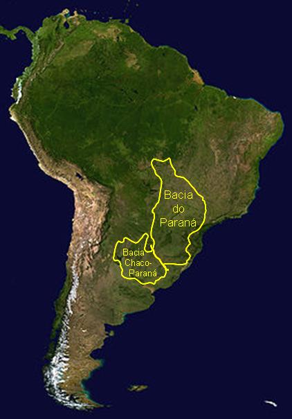
The Paraná-Paraguay Basin is a vast and important river system in South America, primarily located in Argentina, Paraguay, and Brazil. It is one of the largest river basins in the region, draining an area of approximately 2.6 million square kilometers. The basin is formed by the confluence of the Paraná River and the Paraguay River, which flow through a series of diverse landscapes, including plains, wetlands, and forests.
The Paraná River is one of South America’s longest rivers, running through Brazil, Paraguay, and Argentina before emptying into the Atlantic Ocean. The Paraguay River, a major tributary, flows along the border between Argentina and Paraguay. Together, they provide a crucial waterway for transportation, trade, and agriculture.
The basin is vital for the economies of the three countries, supporting activities such as fishing, agriculture, and hydroelectric power generation. Itaipú Dam, located on the Paraná River between Brazil and Paraguay, is one of the world’s largest sources of hydropower.
Ecologically, the basin is rich in biodiversity, including species unique to the Pantanal wetlands, one of the largest tropical wetland areas in the world. The Paraná-Paraguay Basin thus plays a central role in both the environmental and economic landscapes of South America.
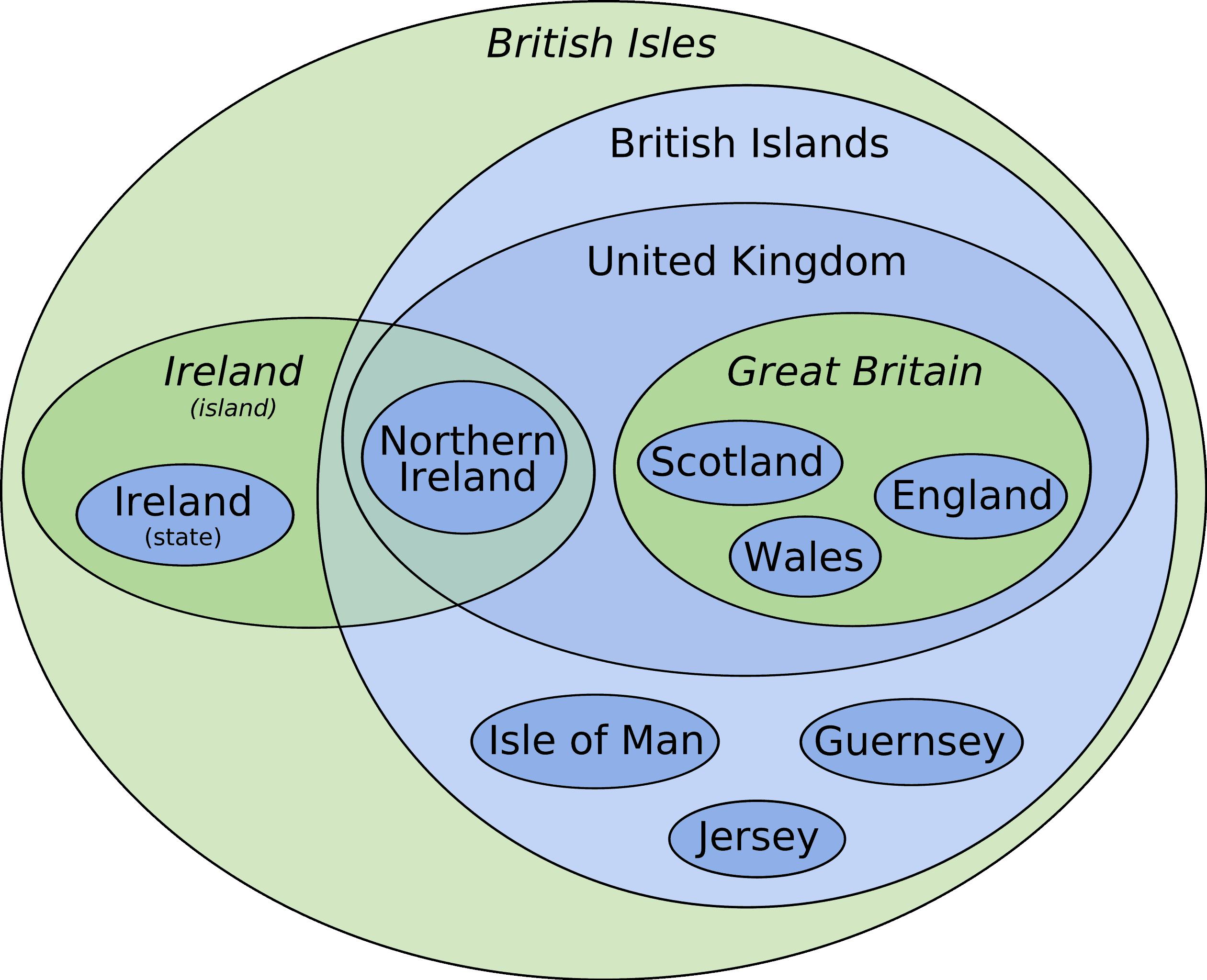
The British Isles is a group of islands located to the northwest of mainland Europe, comprising the United Kingdom (England, Scotland, Wales, and Northern Ireland) and the Republic of Ireland. Geographically, the British Isles are divided into two main regions: Great Britain (which includes England, Scotland, and Wales) and the island of Ireland (which is divided into Northern Ireland and the Republic of Ireland).
The region’s economy has historically been driven by agriculture, industry, and trade. Over time, the United Kingdom became an industrial powerhouse, especially during the Industrial Revolution, with a focus on industries like textiles, coal mining, shipbuilding, and engineering. Today, while manufacturing still plays a role, the economy is heavily based on services, particularly in finance, technology, and tourism.
In terms of climate, the British Isles have a temperate maritime climate, with relatively mild temperatures, high rainfall, and frequent cloud cover. This has fostered lush vegetation and rich agricultural lands, supporting industries such as farming (wheat, barley, and livestock) and fisheries.
Culturally, the British Isles are known for their rich history, including landmarks like Stonehenge, Edinburgh Castle, and the Tower of London. The region is also renowned for its influence on literature, politics, and global trade. The British Isles thus represent a dynamic and historically significant region with deep cultural and economic impact on the world.
In geography, the term “compage” refers to the structure or arrangement of different geographical features, such as the way in which landscapes, landforms, or natural elements are organized and interconnected. It describes how various parts of a geographical area or environment are assembled and related to one another, often influencing the overall landform development or ecosystem dynamics.
For instance:
- The compage of mountain ranges could involve the arrangement of different peaks, valleys, and ridges.
- The compage of river systems involves the way tributaries, streams, and the main river are arranged within a drainage basin.
Understanding the compage of an area helps geographers analyze patterns in topography, climate, and human settlement, as well as assess natural processes such as erosion, sedimentation, or the effects of climate change.
Functional Regions
Functional regions, also known as ‘nodal regions,’ are formed based on functional relationships or interactions that occur around a central hub or focal point. This focal point could be anything – a city, an airport, or a shopping mall. The intensity of interaction decreases as one moves further away from the node.
Commuter areas, like those surrounding a major city, are prime examples of functional regions. Other instances can be the broadcast area of a radio station, or the service area of a plumbing company.
Functional regions are characterized by:
- Central node with a functional relationship
- Decreasing intensity of interaction with increasing distance from the node
- Example: Amazon delivery area
Historical geography is the branch of geography that studies the ways in which geographic phenomena have changed over time. In its modern form, it is a synthesizing discipline which shares both topical and methodological similarities with history, anthropology, ecology, geology, environmental studies, literary studies, and other fields. Although the majority of work in historical geography is considered human geography, the field also encompasses studies of geographic change which are not primarily anthropogenic. Historical geography is often a major component of school and university curricula in geography and social studies. Current research in historical geography is being performed by scholars in more than forty countries.
Themes
This sub-branch of human geography is closely related to history, environmental history, and historical ecology.
Historical geography seeks to determine how cultural features of various societies across the planet emerged and evolved by understanding their interaction with their local environment and surroundings.
More recent studies make use of non-traditional methods, such as botany and archeology.
Development of the discipline
In its early days, historical geography was difficult to define as a subject. A textbook from the 1950s cites a previous definition as an ‘unsound attempt by geographers to explain history’. Its author, J. B. Mitchell, came down firmly on the side of geography: ‘the historical geographer is a geographer first last and all the time’. By 1975 the first number of the Journal of Historical Geography had widened the discipline to a broader audience: ‘the writings of scholars of any disciplinary provenance who have something to say about matters of geographical interest relating to past time’.
In the United States, the term historical geography is the name given by Carl Ortwin Sauer of the University of California, Berkeley to his program of reorganizing cultural geography (some say all geography) along regional lines, beginning in the first decades of the 20th century. To Sauer, a landscape and the cultures in it could only be understood if all of its influences through history were taken into account: physical, cultural, economic, political, environmental. Sauer stressed regional specialization as the only means of gaining sufficient expertise on regions of the world. Sauer’s philosophy was the principal shaper of American geographic thought in the mid-20th century. Regional specialists remain in academic geography departments to this day. Despite this, some geographers feel that it harmed the discipline; that too much effort was spent on data collection and classification, and too little on analysis and explanation. Studies became more and more area-specific as later geographers struggled to find places to make names for themselves. These factors may have led in turn to the 1950s crisis in geography, which raised serious questions about geography as an academic discipline in the USA.
The European Union is a 1993 international organization made up of European countries. It came into effect after 28 countries signed the Maastricht Treaty. The European Union now has 27 members (the UK made an exit from the EU on 31st January 2020). The last country to enter the EU was Croatia in 2013. It was established on November 1, 1993. The headquarters are based in Brussels and Luxembourg.
What is European Union?
- The European Union is a 1993 international organization made up of European countries.
- It came into effect after 28 countries signed the Maastricht Treaty.
- The Treaty of Maastricht is also known as the Treaty of the European Union (TEU). The city of Maastricht is located in the Netherlands.
- It was amended three times. The amendments are:
- The Amsterdam Treaty (1997)
- The Nice Treaty (2001)
- The Lisbon Treaty (2007)
- There are 24 official languages of the European Union.
- The Euro is the official currency of 19 of these countries. 9 EU members do not use the euro: Bulgaria, Croatia, Czech Republic, Denmark, Hungary, Poland, Romania, Sweden, and the United Kingdom.
- The EU arose from a desire to create a unified European political entity to put an end to decades of conflict between European countries, which peaked in World War II and annihilated most of the continent.
- The EU has created an internal single market by establishing a uniform set of regulations that apply to all member states in situations where they have agreed to function as one.
The Amazon Basin is a vast geographical area in South America, primarily located in Brazil, but also extending into Peru, Colombia, Venezuela, Ecuador, Bolivia, Guyana, Suriname, and French Guiana. It is the largest river basin in the world, covering approximately 7 million square kilometers, and is drained by the Amazon River, the largest river by discharge volume globally.
The Amazon Basin is known for its rich biodiversity and is often referred to as the “lungs of the Earth” due to the significant role its rainforests play in absorbing carbon dioxide and producing oxygen. The region contains one of the world’s most extensive and diverse ecosystems, including thousands of plant species, animals, and indigenous communities.
Economically, the Amazon Basin is crucial for its natural resources, including timber, rubber, minerals, and agriculture, particularly soy and cattle farming. However, the area faces increasing pressure from deforestation, mainly driven by agricultural expansion, illegal logging, and infrastructure development.
The Amazon also plays a vital role in climate regulation, influencing weather patterns not just in South America, but globally. Its conservation is critical to maintaining global biodiversity and mitigating climate change.
Petroleum in West Asia is a key component of the region’s economy and global energy supply. West Asia, often referred to as the Middle East, is home to some of the world’s largest oil reserves and is a dominant player in the global petroleum market. The region includes major oil-producing countries such as Saudi Arabia, Iraq, Iran, Kuwait, the United Arab Emirates (UAE), Qatar, and Oman.
The Persian Gulf is particularly rich in oil reserves, with countries like Saudi Arabia holding some of the largest reserves globally. Saudi Arabia, a member of the Organization of the Petroleum Exporting Countries (OPEC), has been a major global oil exporter for decades. Iraq and Iran are also significant producers, while countries like Kuwait and the UAE play critical roles in oil extraction and export.
Petroleum in West Asia has shaped the region’s economy, providing substantial revenue through oil exports. The global oil price often fluctuates based on geopolitical events in the region. The economic importance of oil has spurred infrastructure development, especially in oil fields, pipelines, and refineries, and has driven investments in petrochemicals, natural gas, and energy sectors.
However, the reliance on petroleum also exposes the region to challenges, such as fluctuating oil prices, environmental concerns, and the need to diversify economies amid global shifts toward renewable energy. Additionally, political and geopolitical tensions often affect oil production and distribution in this vital region.
The economy of Argentina is the second-largest in South America and is characterized by its diverse sectors, including agriculture, industry, and services. Historically, Argentina’s economy has been heavily reliant on agricultural exports, with products like soybeans, wheat, corn, beef, and wine being key contributors to its GDP. The country is one of the world’s largest exporters of soybean products and beef, making agriculture a cornerstone of its economy.
The industrial sector is another significant part of Argentina’s economy, with industries such as automobile manufacturing, textiles, steel, and chemicals playing important roles. Additionally, the country has a growing technology and renewable energy sector, particularly in solar and wind power.
The services sector is the largest contributor to Argentina’s GDP, with finance, real estate, tourism, and education being major components. Buenos Aires, the capital, is an economic and financial hub, hosting numerous international corporations and institutions.
However, Argentina faces economic challenges, including high inflation, external debt, and economic instability. The country has experienced recurrent financial crises, devaluation of the peso, and poverty issues. Argentina’s economic policies, such as government intervention, trade restrictions, and attempts to diversify its economy, continue to shape its path forward.
Despite these challenges, Argentina remains an important global player in agriculture, industry, and regional trade, particularly within Mercosur, the Southern Common Market.
Introduction
Natural regions refer to geographical areas with distinct physical features, such as climate, landforms, vegetation, and soil types. These regions are defined by natural boundaries and are characterized by specific ecological characteristics.
Planning regions, on the other hand, are administrative divisions created for the purpose of efficient governance and resource management. These regions are often delineated based on political boundaries, economic considerations, or social factors, and may not always align with natural features.
Body

Conclusion
Looking forward, striking a balance between the preservation of natural regions and the efficient planning of administrative regions will be crucial for sustainable development. By leveraging the unique characteristics and functions of each type of region, we can foster resilience, promote biodiversity, and ensure equitable access to resources for generations to come.
The Monsoon Region in Asia refers to areas in the continent that experience distinct seasonal weather patterns driven by the monsoon winds, which bring heavy rainfall and influence the climate. This region includes parts of South Asia, Southeast Asia, and East Asia, and is vital for agriculture and the economies of many countries in the region.
Monsoons are characterized by wet and dry seasons. The wet season occurs during the summer monsoon (from June to September), when moist air from the Indian Ocean and Bay of Bengal is drawn inland, bringing heavy rains. The dry season follows the winter monsoon (from October to March), when cooler, drier air flows from the north.
Key areas affected by the monsoon include:
- India, where the Southwest Monsoon brings rains essential for agriculture, especially in rice and wheat production.
- Bangladesh, Nepal, and parts of Pakistan also rely heavily on monsoon rains for crop cultivation.
- Southeast Asia, including Thailand, Vietnam, Indonesia, and the Philippines, experiences heavy rainfall and tropical storms during the monsoon season.
- Parts of China and Korea are influenced by monsoonal winds, impacting their agricultural cycles.
The monsoon is crucial for the economy of these regions, especially for farming, but it also brings challenges such as flooding, landslides, and droughts in some areas due to the variability of rainfall. The monsoon also impacts the environment, sustaining forests, wetlands, and water supplies. However, the changing nature of monsoons due to climate change poses a growing threat to the region’s agriculture and infrastructure.
Coniferous Forests- The coniferous forest biome is also referred to as taiga or boreal forest and this sort of forest is mostly characterized based on the presence of coniferous trees, which include pines, spruces, and firs. They are mostly found in the northern hemisphere, at higher latitudes and altitudes, in areas that are characterized by long and cold winters and shorter summer seasons. They are found throughout Europe, Asia, and North America.
Characteristics of Coniferous Forests
As compared to tropical rainforests, coniferous forests are more consistent and also have moderate density. Coniferous forests are characterized by straight, tall-growing trees and are mostly universally evergreen. There is no annual replacement of leaves and for up to 5 years same leaves persist. Conifers are shaped like cones and their slope branches and conical shape avoid accumulation of snow. The soil of coniferous forests is weak and quite acidic and leached overtly.
High-elevation areas like mountains have the presence of coniferous forests. However, even coniferous cannot sustain in extreme slopes.
Distribution of Coniferous Forests
Coniferous forests are situated between temperate deciduous woods in the south and tundra in the north. They are found in the following places majorly:
North America
They are found in North America from Labrador on the east coast to Alaska on the west coast and area is for about 2000 kilometer from north to south and 11 percent of the coniferous forests is found in America and 24 percent is found in Canada.
Asia and Europe
From Siberia to Scandinavia, coniferous forests cover most of Europe as well as Asia. Asia consists largest portion of the forest at around 3000 kilometers, 58 percent of Russia is covered by coniferous forests and 4 percent of Sweden, Finland and Norway, and 3 percent of China and Mongolia.
Fauna of Coniferous Forests
Coniferous forests is home to various herbivores which includes moose, caribou, deer, elk, hare etc. Herbivores have developed hibernation qualities due to which they can survive in harsh conditions and temperatures. Carnivores such as fox, lynx, black bear, otter, shrews etc. can also be found.
In birds, some of the important creatures which can be seen include cranes, ducks, goshawks, great horned owls, ospreys etc.
Economic Importance of Coniferous Forests
Economic importance of coniferous forests is that it is source of world’s largest timber and also pulp production. They grow fast and hence have good properties of wood, and are ideal for timber. Coniferous forests are known for their use as pulp in production of paper and also as Christmas tree. Some conifers are also edible like pine nutes.
Horticulture in the Mediterranean realm of Europe is an essential agricultural activity, influenced by the region’s unique climate, characterized by hot, dry summers and mild, wet winters. This climate is ideal for the cultivation of a wide range of fruits, vegetables, and flowers, making the Mediterranean region one of the world’s most productive horticultural areas.
Key aspects of Mediterranean horticulture include:
Fruit production: The region is known for producing a variety of fruits, particularly citrus fruits like oranges, lemons, and grapefruits, especially in Spain, Italy, and Turkey. Other major fruits grown include olives, grapes (for wine production), almonds, figs, and pomegranates.
Vegetable farming: The Mediterranean is also a major producer of tomatoes, artichokes, peppers, and cucumbers. Tomatoes, in particular, are widely grown in Spain and Italy and are used in numerous culinary traditions.
Olive cultivation: Olives are a staple of the Mediterranean diet and are grown extensively in countries like Spain, Italy, and Greece. The region is a major producer of olive oil, with high-quality oils being a significant export.
Flower production: The Mediterranean climate is also ideal for the growth of a variety of flowers, such as lavender, roses, and chrysanthemums, which are cultivated both for domestic use and for export.
Viticulture: The cultivation of grapes for wine production is central to Mediterranean horticulture, especially in France, Italy, and Spain. The region’s long history of wine production is supported by its varied microclimates, which are perfect for growing different types of grapes.
Greenhouse farming: In areas with more extreme weather, such as parts of southern Spain, greenhouse farming allows for year-round production of fruits and vegetables, including strawberries and lettuce.
Horticulture in the Mediterranean is integral to both local cuisine and economies, supporting both domestic consumption and export markets. However, the sector faces challenges such as water scarcity and climate change, which threaten the sustainability of some crops, prompting innovations in irrigation and sustainable farming practices.
The Great Lakes Region refers to a vast and economically important area in North America centered around the Great Lakes — five large freshwater lakes: Lake Superior, Lake Michigan, Lake Huron, Lake Erie, and Lake Ontario. The region spans parts of the United States (primarily the states of Minnesota, Wisconsin, Illinois, Indiana, Michigan, Ohio, Pennsylvania, and New York) and Canada (mainly the province of Ontario).
Key Features and Importance:
Geographical Significance: The Great Lakes are the largest group of freshwater lakes by total area in the world, covering around 244,000 square kilometers. They form a critical part of the St. Lawrence Seaway, which connects the interior of North America to the Atlantic Ocean, facilitating international trade.
Economic Role: The Great Lakes Region is one of the most economically significant areas in North America. The lakes support industries such as shipping, manufacturing, agriculture, and fishing. The region has historically been a hub for steel production, automobile manufacturing, and chemical industries, particularly in cities like Detroit, Cleveland, and Chicago.
Agriculture: The fertile lands around the Great Lakes support the growth of crops like wheat, corn, soybeans, and fruit, as well as dairy and livestock farming, particularly in states like Michigan and Wisconsin.
Environmental Importance: The Great Lakes are critical for their biodiversity and freshwater supply, providing drinking water to millions of people. However, the lakes face environmental challenges, including pollution, invasive species, and the effects of climate change.
Recreation and Tourism: The Great Lakes are a major destination for tourism and recreation, with activities such as boating, fishing, beach tourism, and hiking. The surrounding areas are known for their natural beauty, including parks, beaches, and forests.
Overall, the Great Lakes Region is a vital economic and environmental hub, with a rich history tied to trade, industry, and natural resources. However, it faces challenges related to sustainability and environmental conservation, particularly in balancing industrial activity with the protection of the lakes’ ecosystems.
Wheat farming in Canada is a vital component of the country’s agricultural industry, particularly in the prairie provinces of Saskatchewan, Alberta, and Manitoba, which are collectively known as the Canadian Wheat Belt. Canada is one of the world’s largest producers and exporters of wheat, particularly hard red spring wheat and durum wheat.
Key Features of Wheat Farming in Canada:
Geographic Distribution: The Canadian Wheat Belt, with its prairie landscape, provides ideal conditions for wheat cultivation. The region’s fertile soil, particularly Chernozem soil, and climate — with long, hot summers and cold winters — support the growth of high-quality wheat crops.
Types of Wheat:
- Hard Red Spring Wheat is Canada’s primary wheat variety, known for its high protein content, making it ideal for bread-making.
- Durum Wheat is another significant variety grown in Canada, especially in Saskatchewan, and is used for pasta production.
- Soft Red Winter Wheat and hard white wheat are also grown, though to a lesser extent.
Production and Exports: Canada produces millions of tons of wheat annually, with Saskatchewan alone accounting for over half of the country’s total wheat production. The majority of Canada’s wheat is exported, with key markets including the United States, China, Japan, and countries in the Middle East and Africa.
Farming Techniques: Wheat farming in Canada relies on advanced agricultural technologies, including precision farming, genetically modified seeds, and irrigation. The country also emphasizes sustainable farming practices, such as crop rotation and reduced tillage, to preserve soil health.
Challenges: Wheat farming faces challenges such as climate change, drought, pests (like the wheat midge), and global price fluctuations. In addition, trade policies and export restrictions can impact the profitability of Canadian wheat farming.
Economic Impact: Wheat is a major economic driver in Canada, contributing to the country’s agricultural GDP and providing jobs in farming, processing, transportation, and exporting industries. The Canadian Wheat Board (CWB), until its privatization, played a crucial role in regulating wheat sales and exports.
In conclusion, wheat farming is a cornerstone of Canada’s agricultural economy, with the country playing a critical role in global wheat production and export. The sector continues to adapt to challenges such as climate variability, market fluctuations, and technological advancements.
Development of Systematic Geography
Karl Ritter, a German geographer, is credited with developing systematic geography. Systematic geography, also known as physical geography or chorology, is a subfield of geography that focuses on the study of the Earth’s physical features, climate, and natural resources.
Karl Ritter
Background
– Karl Ritter was born on August 7, 1779, in Quedlinburg, Germany.
– He studied at the University of Halle, where he was influenced by the works of philosophers such as Immanuel Kant and Johann Gottfried Herder.
Contributions to Geography
– Ritter is considered one of the founders of modern geography.
– He viewed geography as a holistic science that integrated physical, human, and regional aspects.
– Ritter emphasized the importance of studying the relationship between humans and their environment.
– He believed that geography should be based on empirical observation and systematic analysis.
– Ritter’s approach to geography included the classification and description of physical features, the study of climate and weather, and the analysis of how these factors influenced human activities and societies.
Systematic Geography
– Ritter’s most significant contribution to geography was the development of systematic geography.
– He organized the discipline into a systematic framework by dividing it into physical geography and cultural or anthropological geography.
– Ritter believed that understanding the physical environment was crucial for understanding human societies and their development.
– He emphasized the interconnections between physical processes, such as climate and landforms, and human activities, such as agriculture, trade, and settlement patterns.
– Ritter’s approach to geography laid the foundation for further developments in the discipline, including the study of biogeography, geomorphology, climatology, and other subfields within physical geography.
The drainage system of Asia is vast and diverse, covering multiple river basins that drain into different seas, oceans, and lakes. Asia, being the largest continent, has some of the longest and most significant rivers in the world, serving as crucial lifelines for agriculture, industry, and transportation.
Major River Systems
The Indus River System:
- Originating in the Tibetan Plateau, the Indus River flows through India and Pakistan before emptying into the Arabian Sea.
- It is vital for agriculture, particularly in Pakistan, where it supports irrigation for one of the world’s largest irrigation systems, the Indus Basin Irrigation System.
The Ganges-Brahmaputra River System:
- The Ganges flows through India and Bangladesh, while the Brahmaputra starts in Tibet and flows into India and Bangladesh.
- This system is crucial for millions of people in the Ganges Plain and the Bengal Delta, supporting dense populations and providing water for agriculture.
The Yangtze River:
- The Yangtze, the longest river in Asia and the third-longest in the world, flows through China from the Tibetan Plateau to the East China Sea.
- It is central to China’s economy, especially in the eastern regions, supporting agriculture, trade, and hydroelectric power generation (such as the Three Gorges Dam).
The Yellow River (Huang He):
- Flowing through northern China, the Yellow River is known for its historical significance but also its propensity to cause flooding.
- It is critical for farming in China, particularly in the Loess Plateau, and is called “China’s Sorrow” due to its frequent devastating floods.
The Mekong River:
- Flowing through China, Myanmar, Thailand, Laos, Cambodia, and Vietnam, the Mekong is an important river for agriculture, especially rice cultivation in Southeast Asia.
- It empties into the South China Sea, supporting millions of people along its basin.
The Amur River:
- The Amur River forms part of the boundary between Russia and China and flows into the Sea of Okhotsk.
- It is important for local economies, providing water for irrigation, fishing, and transportation.
The Tigris-Euphrates River System:
- These two rivers flow through Turkey, Syria, Iraq, and Iran, draining into the Persian Gulf.
- Known for supporting the Mesopotamian Civilization, they continue to be crucial for agriculture and water supply in the region.
Other Rivers:
- The Lena, Ob, and Yenisey rivers in Siberia drain into the Arctic Ocean.
- The Limpopo, Ganges, and Irrawaddy also contribute to regional drainage systems in their respective areas.
Key Features of Asia’s Drainage System
- Diverse Climate Zones: Asia’s drainage systems are affected by diverse climates, including tropical, temperate, arid, and polar zones.
- Seasonal Variations: Rivers in South Asia (like the Ganges) experience significant monsoon flooding, while in Central Asia, rivers may dry up due to aridity.
- Flooding and Irrigation: Asia’s rivers are often subject to seasonal flooding, which can be both a blessing (for soil fertility) and a curse (leading to destruction). Irrigation systems are vital for supporting agriculture in these river basins.
Winter rainfall in Asia is a significant climatic feature in certain parts of the continent, particularly in South Asia, the Mediterranean region, and parts of East Asia. This rainfall is primarily influenced by the westerly winds and the movement of the monsoon system, which shifts during the winter months.
In South Asia, particularly in India, Pakistan, and parts of Nepal, winter rainfall occurs as a result of the northeast monsoon, which is driven by the seasonal shift of the intertropical convergence zone (ITCZ) and the northern hemisphere high-pressure systems. This wind pattern brings cool, dry air from the Himalayas and Central Asia, but in coastal regions like Tamil Nadu and parts of Sri Lanka, it leads to significant rainfall. The northeast monsoon affects mainly the eastern coastal areas of the subcontinent between October and December, delivering vital moisture to these regions.
In East Asia, particularly in China, Korea, and Japan, winter rainfall is influenced by the winter monsoon that brings cold air from the Asian interior. In Japan, the combination of this cold, dry air from the Siberian high and moisture from the Pacific Ocean results in heavy snowfall on the western and northern coasts, particularly on the Sea of Japan side. This is important for the agriculture of the region, as it contributes to water resources for the dry winter months.
In the Mediterranean region of Asia, especially in Turkey, winter rainfall is also important, as it is a characteristic feature of the Mediterranean climate. Rainfall during this period is due to the influence of low-pressure systems from the Atlantic Ocean and the orographic effect on mountains, which causes moist air to rise and condense, leading to significant winter rains.
Winter rainfall is crucial for replenishing water tables, supporting agriculture, and sustaining ecosystems in various parts of Asia, though it varies significantly depending on the region and prevailing atmospheric patterns.
Coal mining in Europe has a long history and has played a critical role in the continent’s industrial development. Although coal production has significantly declined in recent decades due to environmental concerns and the transition to cleaner energy sources, it remains an important part of the energy mix in some countries. Historically, coal mining was central to the Industrial Revolution, fueling factories, railways, and power plants across Europe.
The most prominent coal-producing regions in Europe were historically in countries like the United Kingdom, Germany, Poland, and Ukraine. The UK was one of the first countries to industrialize and relied heavily on its South Wales and Northern England coalfields. However, coal mining in the UK has largely declined since the 1980s, with many mines being closed due to a combination of economic factors, labor disputes, and the shift towards natural gas and renewable energy.
In Germany, coal mining remains significant, particularly in the Rhineland and Saarland regions. Despite the country’s commitment to decarbonizing its energy sector, lignite (brown coal) mining continues to be a major industry, with Germany being one of the largest producers of lignite in Europe. However, the German government has committed to phasing out coal by 2038 as part of its broader climate strategy.
Poland is another key coal producer in Europe, with extensive coal reserves in the Upper Silesian Basin. The country’s reliance on coal for electricity generation remains high, but there are growing calls for reducing coal dependence due to EU emissions reduction targets and environmental concerns.
Overall, while coal mining has shaped Europe’s industrial landscape, the future of the sector is increasingly uncertain as countries work toward meeting climate goals and transitioning to cleaner energy sources like wind, solar, and natural gas. The coal industry is being phased out gradually in many countries, yet it still plays an important economic role in certain regions, particularly in Central and Eastern Europe.
Urbanization in Europe has been a transformative process, deeply influencing the continent’s social, economic, and environmental landscape. Over the past few centuries, particularly since the Industrial Revolution, Europe has experienced significant growth in urban populations, leading to the development of megacities and large urban areas. The movement of people from rural to urban areas was initially driven by the need for industrial jobs, with cities becoming centers of manufacturing, trade, and services.
In the 19th and early 20th centuries, countries like Britain, Germany, and France saw rapid urbanization as industries such as coal mining, steel production, and textiles flourished. This trend continued in the second half of the 20th century, with cities like London, Paris, and Berlin growing in size and importance as centers of commerce, culture, and politics. Today, Europe is home to some of the most densely populated urban regions, with the Paris metropolitan area, the Ruhr Valley in Germany, and the Greater London Area being prominent examples.
However, the pace of urbanization in Europe has slowed in recent decades compared to regions like Asia and Africa. Many European countries are experiencing aging populations, and urban growth is often associated with suburbanization rather than expansion of city cores. This shift has led to the spread of cities into surrounding areas, creating urban sprawl and increasing pressures on infrastructure, housing, and transportation systems.
Urbanization in Europe has also raised concerns about sustainability, with many cities implementing green urban planning, public transportation networks, and sustainable housing solutions. Overall, while the urbanization trend has slowed, Europe’s cities continue to be vital economic and cultural hubs, facing the challenge of balancing growth with environmental responsibility and quality of life for residents.
The Appalachian Region is a culturally and geographically significant area in the eastern United States, stretching from Alabama in the south to Maine in the north. It is centered around the Appalachian Mountains, a range that runs parallel to the eastern coastline and is known for its rugged terrain, rolling hills, and forested landscapes. The region is divided into several sub-regions, including the Southern Appalachians, Central Appalachians, and Northern Appalachians, each with unique characteristics in terms of topography, climate, and culture.
Historically, the Appalachian Region played a key role in the early settlement of the United States. It was home to indigenous peoples, including the Cherokee and Iroquois. In the 18th and 19th centuries, European settlers moved into the region, and the Appalachian Mountains became a natural barrier, shaping the movement of people and goods. The region became known for its mining, particularly coal mining, and was a major source of natural resources for the industrializing nation.
In modern times, the Appalachian region has faced economic challenges due to the decline of the coal industry and the shift towards a more service-oriented economy. Despite these challenges, the area remains known for its natural beauty, including national parks like the Great Smoky Mountains and Shenandoah National Park. Tourism, particularly outdoor recreation such as hiking, fishing, and mountain biking, has become an important industry. The region is also famous for its unique culture, including Appalachian music, crafts, and cuisine, which continue to play a significant role in its identity.
Today, the Appalachian region faces efforts to balance economic development with environmental preservation, as it continues to be a focal point for both cultural heritage and sustainable tourism
Sheep rearing in Australia is one of the country’s most important agricultural industries, with Australia being one of the world’s leading producers of wool and meat from sheep. Sheep farming is primarily concentrated in the southern and eastern regions, including New South Wales, Victoria, and South Australia, where the climate and landscape are most suitable for raising sheep. The Murray-Darling Basin and Tasmania are also significant sheep-rearing areas, benefiting from fertile land and ample grazing pastures.
Australia is renowned for its production of wool, particularly Merino wool, which is considered one of the finest in the world. The country’s vast sheep stations, often covering tens of thousands of hectares, are dedicated to raising sheep for wool production. In addition to wool, Australia is a major exporter of lamb and mutton, with countries such as China, the Middle East, and Europe being key markets for Australian sheep products.
The sheep industry in Australia faces various challenges, including drought, livestock diseases, and the global market volatility. The harsh climatic conditions in much of the country can make grazing difficult, and farmers must manage water resources carefully to sustain their flocks. In recent years, there has also been growing concern about the welfare of animals and the sustainability of farming practices, leading to the adoption of more sustainable and ethical farming methods.
Despite these challenges, sheep rearing remains a cornerstone of Australian agriculture, contributing significantly to the economy, rural communities, and the global wool market. The industry continues to innovate, using technology and sustainable practices to maintain its competitiveness and meet the growing demand for high-quality wool and meat.
The South Asian Association for Regional Cooperation (SAARC) is an organization of South Asian nations established in 1985 to promote regional cooperation and development. The member countries of SAARC are Afghanistan, Bangladesh, Bhutan, India, Maldives, Nepal, Pakistan, and Sri Lanka. These countries share historical, cultural, and geographical ties, and together they form one of the most populous and diverse regions in the world, with a combined population exceeding 1.8 billion people.
SAARC’s primary objectives are to promote economic cooperation, regional integration, peace, and development among its members. It focuses on areas such as trade, poverty alleviation, environmental protection, social development, and cultural exchange. The organization works through various regional initiatives and frameworks, such as the SAARC Development Fund and the South Asian Free Trade Area (SAFTA), to foster collaboration and facilitate the sharing of resources.
Despite its potential, SAARC has faced challenges due to political tensions among some member states, particularly between India and Pakistan. These tensions have sometimes hindered the effectiveness of the organization in addressing regional issues. Additionally, the lack of economic integration and coordination has limited the success of many of its initiatives.
Nevertheless, SAARC remains an important platform for regional dialogue and cooperation in South Asia. Its member countries continue to work together in addressing common challenges such as climate change, regional security, human rights, and socio-economic development. The organization is seen as a critical player in shaping the future of South Asia’s political and economic landscape.
Australia is one of the world’s leading producers of wheat, with vast areas dedicated to wheat cultivation, primarily in the southern and eastern regions of the country. The main wheat-producing areas in Australia are in the Murray-Darling Basin, which spans across New South Wales, Victoria, and South Australia, and the Wheatbelt region in Western Australia. These areas benefit from fertile soils, adequate rainfall, and a temperate climate that supports wheat farming.
The Wheatbelt of Western Australia is the largest and most productive wheat-growing region in the country, contributing to more than half of Australia’s total wheat production. Key wheat-growing regions within this area include Esperance, Albany, and the Central Wheatbelt. The region is known for its dryland farming techniques, where farmers rely on rain-fed water systems to irrigate crops, making it vulnerable to climatic fluctuations such as drought.
In South Australia, the Murray Plains and areas surrounding the Barossa Valley are significant wheat-producing regions. This area is known for its high-quality wheat, which is often used for milling purposes. Similarly, in New South Wales, the Riverina region and parts of central New South Wales are major contributors to wheat production.
Australia’s wheat-growing regions face challenges such as variable rainfall, drought, and the impact of climate change. However, through the use of advanced farming techniques, including genetically modified wheat varieties and precision farming, Australian wheat farmers continue to maintain a competitive edge in the global market. The country remains a major exporter of wheat, particularly to Asia, the Middle East, and Africa.
The concept of region in geography refers to an area defined by certain physical, cultural, or economic characteristics that distinguish it from other areas. A region can be identified based on shared features that make it a distinct unit for analysis or comparison. Geographers use the concept of regions to better understand spatial patterns and the interactions between various factors like climate, human activities, and resources.
Regions can be classified into formal regions, functional regions, and vernacular regions. Formal regions are defined by uniform characteristics, such as a common language, climate, or economic activity. An example of a formal region is the Sahara Desert, which is recognized for its arid climate and desert landscape. Functional regions, on the other hand, are defined by a particular function or activity, such as the transportation network of a city or the economic hub of a metropolitan area. The New York Metropolitan Area is a functional region, where the activities of various interconnected urban centers make it a cohesive unit. Lastly, vernacular regions are based on perceptions or cultural identity, often referred to as “perceived regions.” For instance, the American South is a vernacular region, defined by historical and cultural factors rather than strictly by geographic boundaries.
Understanding regions is important for analyzing global patterns and the impacts of various social, economic, and environmental processes. By studying regions, geographers can identify relationships between people and their environment, leading to insights into regional development, policy-making, and planning. The concept of region helps organize the world into manageable areas for study and fosters a deeper understanding of spatial dynamics.
Rice cultivation in Southeast Asia is a vital agricultural activity, as the region is the world’s largest producer and consumer of rice. Countries like Thailand, Vietnam, Indonesia, Myanmar, and Cambodia are major rice producers, benefiting from the region’s tropical climate, monsoon rains, and fertile soils, particularly in the river deltas and floodplains. Rice is both a staple food and a significant export commodity, driving the agricultural economy in many Southeast Asian nations.
The cultivation of rice in Southeast Asia is largely based on wet rice farming, also known as paddy rice cultivation, where rice is grown in flooded fields. This method is ideal for the clay-rich soils found in the region, which retain water effectively. The Mekong Delta in Vietnam and the Chao Phraya River Basin in Thailand are key rice-producing areas, where irrigation systems are used to manage water levels and increase yields. In some regions, such as the Central Plains of Thailand, rice farming is highly intensive, using modern farming techniques, while in other areas, more traditional methods are still practiced.
The monsoon season is crucial for rice cultivation, as the rainfall provides the necessary water for flooded paddies. However, the dependence on seasonal rains makes rice farming vulnerable to climate change, flooding, and droughts. In recent years, there has been a push towards improving rice production through sustainable practices, water management techniques, and the adoption of high-yield rice varieties to ensure food security and maintain economic stability in the region.
Overall, rice cultivation is not only a key part of the agricultural landscape of Southeast Asia but also central to the cultural identity and economy of the region.
The relief of Brazil is characterized by a diverse range of landforms, which significantly influence the country’s climate, agriculture, and population distribution. Brazil’s landscape can be broadly divided into four main regions: the Brazilian Highlands, the Amazon Basin, the Pantanal, and the coastal plains.
The Brazilian Highlands make up the largest portion of Brazil’s land area. These highlands, also known as the Planalto, are a series of plateaus and mountains that rise between 300 and 1,200 meters above sea level. The Central Highlands are located in the center of the country, while the Southeastern Highlands are home to some of Brazil’s major cities, including São Paulo and Rio de Janeiro. The relief here is shaped by mountain ranges like the Serra do Mar and the Serra da Mantiqueira.
The Amazon Basin is located in the northern part of the country and is dominated by the vast Amazon Rainforest. The region is primarily a lowland area, with the Amazon River and its tributaries forming a complex system of waterways. The Pantanal, a vast wetland area in the west of Brazil, is another key feature of the country’s relief, known for its seasonal flooding and rich biodiversity.
Brazil’s coastal plains are narrow strips of land along the Atlantic Ocean, where major cities such as Salvador and Recife are located. These coastal areas are characterized by beaches, sand dunes, and rocky formations, with a tropical climate that supports a diverse ecosystem.
Overall, Brazil’s relief is varied and influences the country’s agriculture, settlement patterns, and environmental conditions, making it one of the most geographically diverse nations in the world.
- Income levels: Average per capita income, income distribution, poverty levels
- Employment patterns: Unemployment rates, sectoral distribution of employment (agriculture, industry, services)
- Industrial structure: Predominant industries, industrial output, industrial clusters
- Agricultural productivity: Crop patterns, yield levels, land use
- Infrastructure development: Transportation networks, communication facilities, energy availability
- Migration trends: Net migration patterns, labor mobility
- Resource availability: Mineral deposits, water resources, land quality
- Economic activity concentration: Urban centers, market areas, trade flows
| Functional region | Formal region |
(i) Specific to one area. | (i) Often physical in nature. |
(ii) Areas organised around a node or focus one point like university, airport, etc. | (ii) Has specific boundaries that set them apart. |
(iii) This region has no common characteristics, but functions are more important. Functions bind regions together. | (iii) This region has some common characteristics such as common economic activity or common language. |
(iv) Often, a metropolitan area consists of a major city and many smaller towns. | (iv) Homogeneous areas or habitats inhabited by social groups, societies or nations. |
(v) The region is tied to a central point by a transportation system or economic or functional associations. | (v) Organised and represented by small systems or part systems. |
(vi) It functions and works together to form a part of an economic and social system. | (vi) Has clear-cut political boundaries. |
(vii) Defined by a set of activities. | (vii) Defined by common political units where everyone is subject to the same law and government. |
The agricultural resources of West Asia are shaped by the region’s arid and semi-arid climate, with water availability being a critical factor influencing agricultural practices. Despite the challenging environment, agriculture remains an essential sector for many countries in the region, supporting rural livelihoods and contributing to food security.
Key agricultural resources include cereals, fruits, vegetables, and livestock. Staple crops such as wheat and barley are widely grown, particularly in areas with access to irrigation, such as the Tigris-Euphrates River Basin in Iraq and Syria. Date palms are a signature crop of the region, with countries like Saudi Arabia, Iraq, and Iran being major producers of dates. Olives and grapes are also cultivated, especially in countries with a Mediterranean climate, such as Lebanon and parts of Turkey.
Livestock farming is another significant component of agriculture in West Asia. Sheep, goats, and camels are commonly reared, particularly in arid zones where crop farming is less feasible. These animals provide meat, milk, and wool, supporting both subsistence and commercial farming.
Water resources are a critical limiting factor for agriculture in West Asia. The region relies heavily on irrigation systems and aquifers, with some countries, like Saudi Arabia, utilizing fossil water reserves for large-scale farming. Innovations such as drip irrigation and greenhouse farming have been adopted to maximize water efficiency and improve productivity.
In recent years, the region has faced challenges such as water scarcity, climate change, and soil degradation, which threaten agricultural output. Despite these challenges, West Asia’s agriculture continues to play a vital role in meeting domestic food needs and supporting rural economies.
- Climate: Brazil’s mountainous regions, such as Minas Gerais, São Paulo, and Espírito Santo, have moderate altitudes, stable temperatures, and abundant seasonal rainfall. These conditions are ideal for growing coffee plants, which thrive in temperatures between 15°C and 24°C.
- Harvest: The general coffee harvest in Brazil is between May and September. Most plantations are harvested in the dry seasons of June through September.
- Processing: Most coffee in Brazil is processed using the dry process, also called unwashed or natural coffee. The entire berries are cleaned and placed in the sun to dry for 8–10 days.
- Coffee types: 80% of Brazil’s coffee is Arabica. Bourbon Santos is a medium to high-grade wet-processed Brazilian coffee with a light to medium body, low acidity, and a lovely scent.
- Coffee farms: There are roughly 220,000 coffee farms involved in the coffee industry in Brazil. Coffee farms in Brazil range in size from small family-run plantations of less than ten hectares, to large estates in excess of 2,000.
- Climate change: Climate change poses threats to Brazil’s coffee growers.
Milk production in Australia is a vital component of the country’s agriculture sector, contributing significantly to both domestic consumption and exports. Australia is known for its high-quality dairy products, including milk, cheese, butter, and yogurt, which are exported to markets in Asia, the Middle East, and Europe.
The primary regions for milk production in Australia are Victoria, New South Wales, Tasmania, and parts of South Australia and Western Australia. Among these, Victoria leads the industry, accounting for approximately 65% of the country’s total milk output. This dominance is due to the region’s favorable climate, fertile soils, and abundant pasturelands, which support year-round grazing for dairy cattle.
Australia’s dairy industry is characterized by grazing-based systems, where cows primarily feed on natural pastures, ensuring the production of high-quality milk. However, in drier regions or during periods of low rainfall, supplementary feeding with grains and silage becomes necessary. Holstein-Friesian cows are the most common breed used in the industry due to their high milk yield.
The Australian dairy sector faces challenges such as climate variability, drought, and water scarcity, which affect pasture availability and milk production levels. Additionally, the industry is influenced by global market trends and competition from other major exporters like New Zealand and the European Union.
Despite these challenges, the sector remains competitive through the adoption of modern farming techniques, sustainable practices, and technological innovations. Australia’s focus on quality and sustainability has allowed it to maintain a strong presence in the global dairy market while meeting the growing demand for premium dairy products.
Understanding the Concept of Regions
A region, in its most elementary form, is a part of the earth’s surface that is distinguished by one or more shared characteristics. This can be anything from natural phenomena, such as climate or terrain, to cultural attributes, such as language or religion. The concept of regions assists in organizing information and making sense of the world’s vastness and diversity.
Types of Regions
There are three types of regions as follows
- Formal Regions
- Functional Regions
- Vernacular Regions
Formal Regions
Formal regions, often referred to as ‘uniform regions,’ are defined by a common physical or cultural attribute present throughout the region. They showcase a degree of homogeneity in one or more phenomena that distinguish them from surrounding areas.
For instance, political entities like countries, states, and cities fall under formal regions due to shared governance. Other examples include areas characterized by specific climate types, soil types, or language spoken.
Key characteristics of formal regions include:
- Clear and distinct boundaries
- Shared cultural or physical characteristics
- Examples: Sahara Desert (physical), Francophone Africa (cultural)
Functional Regions
Functional regions, also known as ‘nodal regions,’ are formed based on functional relationships or interactions that occur around a central hub or focal point. This focal point could be anything – a city, an airport, or a shopping mall. The intensity of interaction decreases as one moves further away from the node.
Commuter areas, like those surrounding a major city, are prime examples of functional regions. Other instances can be the broadcast area of a radio station, or the service area of a plumbing company.
Functional regions are characterized by:
- Central node with a functional relationship
- Decreasing intensity of interaction with increasing distance from the node
- Example: Amazon delivery area
Vernacular Regions
Vernacular regions, often known as ‘perceived regions,’ are more abstract and less structured than formal or functional regions. They are formed based on people’s perceptions or collective mental map of the world’s geography.
An example of a vernacular region might be “The South” or “The Middle East.” These areas don’t have official boundaries but are recognized by many due to shared cultural or historical understanding.
Features of vernacular regions:
- Subjective boundaries based on perception
- Shared mental construct among people
- Example: Silicon Valley
Characteristics of Regions
Understanding the types of regions provides an essential framework to analyze the world’s complex tapestry. However, irrespective of the type, all regions share certain fundamental characteristics that underscore their significance in the study of geography.
When we examine the types of regions – formal, functional, or vernacular – they all demonstrate unique characteristics that set them apart from one another. Yet, there is a shared set of traits that help us recognize and define these geographic constructs.
Defined by Shared Characteristics
The primary characteristic of any region, regardless of its type, is the presence of one or more shared attributes. This commonality could pertain to physical characteristics such as landforms, climate, or flora and fauna, or it could involve human elements such as language, religion, or economic activity. For instance, the Sahara Desert is a formal region identified by its shared physical characteristic – an arid climate.
Boundaries
Regions possess boundaries that may vary in terms of definition and perception across the different types of regions. Formal regions usually have clearly demarcated boundaries, such as political borders. Functional regions’ boundaries are determined by the extent of interaction or influence of a central node, and can change over time. Vernacular regions, being based on perceptions, have fluid and often debated boundaries.
Spatial Extent
All types of regions occupy a certain space on the earth’s surface. This spatial extent can vary widely, from a small neighborhood to an entire continent, and is determined by the defining characteristics of the region.
Dynamic Nature
Regions are not static; they are dynamic and change over time. Changes in physical conditions, human activities, or perceptions can lead to shifts in the boundaries, characteristics, or even the existence of regions. For instance, the boundaries of a functional region, like a shopping delivery area, could expand or contract based on changes in the company’s operations or customer base.
In essence, a region is more than just a point on a map. Whether formal, functional, or vernacular, regions are spatial representations of the complex interplay between physical and human phenomena. By examining the shared characteristics and the distinct attributes of different types of regions, we can gain deeper insights into the world we inhabit and better understand the complexities of our planet
Methods of Regionalisation
Navigating through the labyrinth of geographical entities to classify the various types of regions is no small feat. This brings us to the next cornerstone of our journey into regions: the process of regionalisation. By carefully employing different methods of regionalisation, geographers and planners delineate areas based on shared characteristics, functional associations, or common perceptions, allowing us to understand and appreciate the intricacies of our planet.
Identifying Shared Characteristics
The first step in regionalisation involves identifying shared characteristics. This process is crucial for defining formal regions, where the commonality could be a physical attribute like climate or terrain, or a human attribute such as language or religion. For instance, areas that experience Mediterranean climate form a formal region.
Analyzing Functional Relationships
The demarcation of functional regions involves analyzing functional relationships and patterns of interaction around a central node. This requires understanding the nature and extent of influence exerted by the central node and how it decreases with distance. This analysis can leverage various tools, from traditional surveys to modern Geographic Information System (GIS) and big data analytics.
Recognizing Perceptions and Mental Maps
Identifying vernacular regions involves recognizing collective perceptions and mental maps. This can be achieved through surveys, interviews, or analysis of discourse in media and literature to understand how people perceive certain areas. For example, recognizing Silicon Valley as a hub for tech startups is based on widespread perception.
Synthesizing Information
The final step in regionalisation involves synthesizing the gathered information to define the regions. It’s important to remember that this process is not rigid but flexible, and the definitions of regions may evolve over time as characteristics, functions, and perceptions change.
Through regionalisation, we give shape and form to the different types of regions, making them meaningful and understandable. By appreciating the methods of regionalisation, we not only comprehend the nature of regions but also unravel the complex web of interrelationships that binds our world together. Regionalisation, therefore, offers us a way to make sense of the dynamic puzzle that is our planet, highlighting once more the immense relevance of understanding the types of regions.
- Climate: Deciduous forests have cold winters and hot, wet summers, with an average yearly temperature of about 10°C. They receive 750 to 1,500 mm of precipitation spread fairly evenly throughout the year.
- Trees: Deciduous forests are dominated by broadleaf trees, such as oak, maple, beech, hickory, and chestnut. In the fall, the trees change color and lose their leaves in preparation for winter.
- Other plants: In addition to trees, deciduous forests also contain shrubs, herbs, mosses, ferns, and wildflowers.
- Wildlife: Deciduous forests are home to many animals, including snails, slugs, insects, spiders, snakes, frogs, salamanders, turtles, warblers, flycatchers, vireos, thrushes, woodpeckers, hawks, owls, mice, moles, chipmunks, rabbits, weasels, foxes, bears, and deer.
- Eastern North America
- Western Eurasia
- Northeastern Asia
- Southwest Russia
- Southern Chile
- Paraguay’s Middle East coast
- New Zealand
- Southern Australia
South Asia is home to a variety of soil types, influenced by its diverse climate, topography, and vegetation. These soils play a critical role in the region’s agriculture, supporting the livelihoods of millions. The primary soil types found in South Asia include:
Alluvial Soils:
These are the most extensive and agriculturally important soils in South Asia, covering the Indo-Gangetic Plain across India, Pakistan, and Bangladesh. They are formed by deposits from rivers like the Ganges, Indus, and Brahmaputra. Alluvial soils are fertile and ideal for cultivating wheat, rice, and sugarcane.Black Soils:
Found primarily in the Deccan Plateau region of India, these soils, also known as Regur soils, are rich in clay and suitable for retaining moisture. They are excellent for growing cotton, hence their nickname, cotton soils.Red Soils:
These soils are common in peninsular India, especially in states like Tamil Nadu, Odisha, and Andhra Pradesh. They are rich in iron oxide, giving them a red color, and are suitable for crops like millets, pulses, and groundnuts.Laterite Soils:
Found in areas with high rainfall and temperatures, such as the Western Ghats and parts of Sri Lanka, laterite soils are used for growing tea, coffee, and rubber. These soils require careful management to prevent nutrient loss.Arid Soils:
Found in the Thar Desert of India and Pakistan, these sandy soils are low in fertility but can support drought-resistant crops like millets with irrigation.Mountain Soils:
Found in the Himalayas and other upland regions, these soils are less fertile but support crops like maize, potatoes, and barley.
These varied soil types highlight South Asia’s agricultural diversity, making the region a significant contributor to global food production.
South America is richly endowed with diverse mineral resources, making it one of the world’s leading regions for mining and resource extraction. The continent’s geological formations, including the Andes Mountains, Brazilian Shield, and Guiana Shield, are key sources of valuable minerals.
One of the most significant resources in South America is iron ore, predominantly found in Brazil, which is a leading global exporter. The Carajás Mine in Brazil is one of the largest iron ore mines in the world. Copper is another crucial mineral, with Chile being the top producer globally, primarily from the Atacama Desert and mines like Escondida. Peru is also a major copper producer.
Gold is extensively mined in countries such as Brazil, Peru, and Colombia, with the Yanacocha Mine in Peru being one of the largest gold mines in the world. Silver is another key resource, with Bolivia, Peru, and Argentina being significant contributors. The Potosí mines in Bolivia are historically renowned for silver extraction.
Bauxite, used for aluminum production, is abundantly found in Suriname, Guyana, and Brazil, while tin is mainly mined in Bolivia. Petroleum and natural gas are crucial resources, especially in Venezuela, which has some of the largest proven oil reserves in the world, and in Ecuador and Brazil.
South America’s mineral wealth plays a vital role in its economy, supporting industries and global exports. However, mining activities also pose challenges such as environmental degradation and the need for sustainable resource management.
- Dominant producer: Australia is the largest producer of wool globally, contributing a significant portion of the world’s Merino wool.
- Merino focus: The majority of Australian wool is Merino wool, prized for its fine fiber quality and softness.
- Extensive grazing: Sheep in Australia roam vast paddocks across diverse landscapes, allowing for optimal wool production.
- Highly developed system: The industry boasts a sophisticated wool marketing system with trained wool classers and detailed testing of each bale to ensure quality.
- Sustainability emphasis: Australian wool producers are increasingly focused on sustainable practices, highlighting the environmental benefits of their wool production.
- Woolmark certification: The “Woolmark” logo is a recognized standard for high-quality Australian wool, providing assurance to consumers.
- Woolgrowers: The backbone of the industry, responsible for raising sheep and shearing the wool on their farms.
- Shearing sheds: Where the wool is harvested from the sheep by skilled shearers.
- Wool classing: The process of sorting wool based on quality and fiber characteristics
- Export market: The majority of Australian wool is exported to international markets, with China being the primary destination
Natural regions are large geographical areas defined by their distinct physical, climatic, and biological characteristics. These regions share common features that differentiate them from other areas and influence the lifestyles, agriculture, and economic activities of the inhabitants. Below are the key characteristics of natural regions:
Uniform Climate:
Each natural region has a specific climatic condition such as tropical, temperate, or polar. This determines the temperature, rainfall patterns, and seasonal variations within the region.Distinct Vegetation and Wildlife:
Natural regions are characterized by their flora and fauna, which adapt to the local climate and soil conditions. For instance, tropical rainforests are rich in biodiversity, while deserts support drought-resistant plants like cacti and hardy animals.Similar Landforms:
The region’s physical geography, such as mountains, plains, plateaus, or valleys, provides a defining feature. For example, the Sahara Desert is dominated by sand dunes, while the Amazon Basin features extensive river systems and lowlands.Homogeneous Soil Types:
A natural region typically has a dominant soil type that supports specific vegetation. For instance, alluvial soils in river plains and laterite soils in tropical regions.Climatic Influence on Human Activities:
The climate of a natural region directly affects agriculture, housing, and lifestyle. For example, people in temperate regions engage in diverse farming, while desert inhabitants rely on irrigation-based agriculture.Economic Resources:
Natural regions may have specific resources, such as timber in forest regions, minerals in mountainous regions, or oil in deserts.
By understanding the characteristics of natural regions, geographers and planners can assess the environmental potential and challenges of a region, aiding in sustainable development and resource management.
Europe has diverse demographic features, shaped by its history, economy, and geography. These features influence the continent’s social, cultural, and economic dynamics. Key demographic characteristics of Europe include:
Population Distribution:
Europe has a highly uneven population distribution, with dense populations in urbanized regions like Western Europe, including Germany, France, and the UK, and sparse populations in Northern Europe, such as parts of Scandinavia. The European Plain and river basins like the Danube and Rhine attract significant settlements due to favorable conditions for agriculture and trade.Urbanization:
Europe is highly urbanized, with over 75% of the population living in cities. Major metropolitan areas such as London, Paris, Berlin, and Moscow are hubs of economic and cultural activity.Population Growth and Aging:
Europe experiences low population growth due to declining birth rates and rising life expectancy. Many countries face aging populations, particularly in Southern and Eastern Europe, where younger generations are shrinking, posing challenges for the workforce and social welfare systems.Ethnic and Cultural Diversity:
Europe is ethnically diverse, with indigenous groups such as Slavs, Germans, and Latins, and immigrant communities from Asia, Africa, and the Middle East. This diversity is most pronounced in Western Europe.Migration Patterns:
Europe has a long history of both inward and outward migration. Recently, there has been significant immigration from conflict zones and developing regions, impacting the demographic composition.Literacy and Education:
Europe boasts high literacy rates and well-developed education systems, contributing to a skilled workforce and strong economic development.Economic Disparities:
While Western and Northern Europe have high standards of living, parts of Eastern and Southern Europe face economic challenges, influencing demographic trends such as emigration and lower birth rates.
These demographic features make Europe a dynamic and complex region, influencing its role in global politics, economics, and cultural exchange.
The Mediterranean realm is a unique geographical region that surrounds the Mediterranean Sea, encompassing parts of Southern Europe, North Africa, and the Middle East. Its distinct geographical features are shaped by its climate, landforms, and vegetation. Key features include:
Climate:
The Mediterranean realm experiences a Mediterranean climate, characterized by hot, dry summers and mild, wet winters. This climate is ideal for certain crops like olives, grapes, oranges, and wheat, making the region agriculturally productive.Landforms:
The region is dominated by mountain ranges, plateaus, and coastal plains. Prominent mountain systems include the Alps in Southern Europe, the Atlas Mountains in North Africa, and the Taurus Mountains in Turkey. The coastal plains, such as those in Spain, Italy, and Egypt, are fertile and heavily populated.Mediterranean Sea:
The Mediterranean Sea is central to the region, influencing its climate, trade, and cultural exchange. It connects Europe, Africa, and Asia, making it a historically significant area for maritime trade and civilizational development.Soil Types:
Soils in the Mediterranean are often calcareous, with terra rossa (red soils) found in hilly regions and alluvial soils in river valleys. These soils are suitable for diverse agricultural activities, particularly vineyards and orchards.Vegetation:
The natural vegetation includes Mediterranean forests, woodlands, and scrublands with drought-resistant species such as oak, pine, and cypress. Shrubs like maquis and garigue are common in drier areas.Rivers and Lakes:
Rivers like the Nile, Po, and Ebro play significant roles in the region’s agriculture and settlements. While the Mediterranean region lacks large freshwater lakes, it has numerous small lakes and lagoons.Cultural Diversity:
The region’s geographical diversity supports a mix of cultures, languages, and traditions, reflecting influences from ancient civilizations such as the Romans, Greeks, and Phoenicians.
The Mediterranean realm’s geography makes it a globally significant region for agriculture, tourism, and historical heritage. Its natural beauty and biodiversity add to its uniqueness, though challenges like deforestation and climate change pose threats to its ecological balance.
The United States of America (USA) is divided into several regions based on geographical, cultural, economic, and climatic characteristics. These regions offer a diverse landscape and contribute uniquely to the nation’s identity. Below are the main regions of the USA:
Northeast:
The Northeast is the smallest but most densely populated region, encompassing states like New York, Massachusetts, and Pennsylvania. Known as the birthplace of the USA, this region features major cities like New York City and Boston and is a hub for finance, education, and manufacturing. Its climate ranges from humid continental to cold winters.Southeast:
Covering states like Florida, Georgia, and Texas, the Southeast has a humid subtropical climate with hot summers and mild winters. It is known for its agriculture, especially cotton, tobacco, and citrus fruits, as well as growing urban centers like Atlanta and Miami.Midwest:
Known as the “breadbasket” of the USA, the Midwest includes states like Illinois, Ohio, and Kansas. Its fertile plains support agriculture, particularly wheat, corn, and soybeans. Cities like Chicago are industrial and cultural hubs.Southwest:
This arid region includes Arizona, New Mexico, and parts of Texas and Oklahoma. It is characterized by deserts, canyons, and a strong influence from Hispanic culture. The Southwest is also rich in natural resources like oil and minerals.West:
Encompassing states like California, Oregon, and Washington, the West is geographically diverse with mountains, coastal areas, and forests. It is known for its tech industry (e.g., Silicon Valley), entertainment (Hollywood), and scenic beauty (e.g., Yosemite, Grand Canyon).Mountain West:
This region includes Colorado, Utah, Nevada, and Idaho, characterized by the Rocky Mountains and high-altitude landscapes. Tourism, skiing, and mining are major economic activities.Pacific Northwest:
States like Washington and Oregon are known for their temperate rainforests, mountains, and tech industries. The region’s economy is supported by forestry, fishing, and high-tech sectors.Alaska and Hawaii:
Alaska is known for its vast wilderness, oil reserves, and cold climate. Hawaii, in the Pacific Ocean, is a tropical region famous for its tourism, unique biodiversity, and volcanic landscapes.
These regions reflect the USA’s vast geographic diversity, influencing its economic activities, cultural identities, and climate conditions.
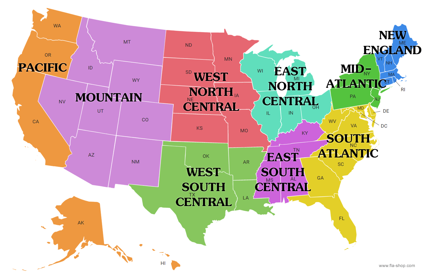
The economic base of Australia is diverse, driven by its natural resources, agriculture, and a well-developed services sector. The country’s economy benefits from its rich mineral deposits, fertile lands, and strategic position in the Asia-Pacific region.
Mining is a cornerstone of Australia’s economy, with the nation being one of the world’s largest exporters of iron ore, coal, natural gas, and gold. The Pilbara region in Western Australia is globally renowned for iron ore production, while coal mining is concentrated in Queensland and New South Wales. These resources contribute significantly to Australia’s exports and drive economic relationships with countries like China, Japan, and India.
The agriculture sector is another key component, supplying both domestic and international markets. Australia is a major producer of wheat, barley, cotton, sugar, and beef. The Murray-Darling Basin is a critical area for agricultural activities, particularly irrigation-based farming.
The services sector, including finance, education, healthcare, and tourism, is the largest contributor to Australia’s GDP. International education and tourism are significant, with cities like Sydney, Melbourne, and Brisbane attracting millions of visitors annually.
Australia’s economy is also known for its innovation in areas like renewable energy and biotechnology, supported by a stable political environment and skilled workforce. These elements make Australia one of the most prosperous nations, with a high standard of living and strong global trade links.
Asia holds immense geographical importance due to its vast size, diverse landscapes, and strategic location. As the largest continent, it spans about 44.58 million square kilometers, covering nearly 30% of the world’s total land area. Asia is home to the world’s highest mountain range, the Himalayas, and the longest river system, the Yangtze and Ganges rivers, which are vital for agriculture, transport, and cultural development in the region.
Asia’s geopolitical significance is unparalleled, as it is a crossroads connecting East and West, with countries like Turkey and Russia straddling both Europe and Asia. The continent has some of the world’s most strategically important straits and canals, such as the Strait of Malacca and the Bosporus, which facilitate global trade routes. The South China Sea, in particular, is crucial for international shipping and holds valuable maritime resources.
Asia’s climate diversity ranges from the arctic conditions in the Siberian regions to the tropical climates in Southeast Asia, influencing its rich biodiversity and agricultural productivity. The region is a major producer of essential crops like rice, wheat, and tea, sustaining billions of people.
Additionally, Asia is a hub for emerging global economic powers, such as China and India, which play critical roles in global trade, technology, and manufacturing. Its geographical features significantly impact the environment, climate change, and socio-economic development globally.
Europe’s physiographic divisions are characterized by a variety of landforms, ranging from towering mountain ranges to vast plains and intricate river systems. These divisions shape the continent’s climate, biodiversity, and human activities.
The Western Uplands:
The Western Uplands stretch from the Scandinavian Peninsula through the British Isles and parts of Iberian Peninsula. These regions feature mountain ranges such as the Scandinavian Mountains and the Pyrenees. The uplands are often rugged and are characterized by ancient rock formations and relatively low population density. These areas are important for forestry and mining.The Central Uplands:
Located in central Europe, this region includes the Massif Central in France, the Bohemian Plateau in the Czech Republic, and the Black Forest in Germany. These areas are marked by rolling hills and basins and are vital for agriculture, particularly cereals and livestock farming.The Northern European Plain:
Extending from the Atlantic coast to the Urals, the Northern European Plain is a vast, low-lying area that includes countries like France, Germany, Poland, and Russia. This region is highly fertile and supports intensive agriculture, particularly wheat, corn, and barley. It is also home to many of Europe’s major cities and industrial centers.The Alpine Region:
The Alps, Pyrenees, and Carpathian Mountains form Europe’s most prominent mountain chains. These rugged mountains influence climate patterns and are known for their tourism, particularly skiing. The Alps act as a climate barrier between Northern Europe and Southern Europe.The Mediterranean Basin:
This region, with its coastal plains and mountainous interior, is characterized by the Mediterranean climate, which influences agriculture (such as citrus and olive production) and the region’s cultural landscape.
These physiographic divisions contribute to the continent’s varied climate, land use, and cultural diversity, making Europe one of the most dynamic regions in the world.