
Human ecology is the study of the interactions of humans with their environments, or the study of the distribution and abundance of humans. This definition is based directlyon conventional definitions of biological ecology. Ecology is usually defined as the studyof interactions of organisms with their environments and each other. More pointedly, itcan be defined as the study of the distribution and abundance of organisms. This definitionis deceptive. It implies much more than it says explicitly because virtually everything thathumans are or do (and the same goes for any species) affects their distribution and abundance.Thus, using the term “human ecology” actually expresses a broad ambition to understand human behavior (Odum, 1968; Odum, and Barrett, 2005).
So, it is the study of the relationships between humans and their environments is a field with a largescope and complex history. It arose out of multiple disciplines—animal biology, anthropology, geology, ecology, and sociology—in the early 1900s as scientists struggled to make sense of the impact of humans on theman-made and natural environment and the impact of environments on the social systems of humans. Humanecology is also viewed by many as a methodology or framework for studying human activities and socialinstitutions, often in conjunction with the health and functioning of the natural environment (Jaiswal, 2013).
Overpopulation or overabundance is a phenomenon in which a species’ population becomes larger than the carrying capacity of its environment. This may be caused by increased birth rates, lowered mortality rates, reduced predation or large scale migration, leading to an overabundant species and other animals in the ecosystem competing for food, space, and resources. The animals in an overpopulated area may then be forced to migrate to areas not typically inhabited, or die off without access to necessary resources.
Judgements regarding overpopulation always involve both facts and values. Animals often are judged overpopulated when their numbers cause impacts that people find dangerous, damaging, expensive, or otherwise harmful. Societies may be judged overpopulated when their human numbers cause impacts that degrade ecosystem services, decrease human health and well-being, or crowd other species out of existence.
Rural settlements are built closely and directly related to land. They are dominated by primary activities such as fishing, animal husbandry, agriculture, etc. The size of rural settlements is comparatively small.
Rural Settlements Types
There are four types of rural settlements in India – compact, semi-compact, hamleted, and dispersed or scattered type of rural settlements.
Compact Settlements
If the total number of hamlets equals the total number of villages in an area unit then the settlement is known as a compact settlement. Compact settlements are found all over the plateau region of Malwa, large parts of Rajasthan, Uttar Pradesh, Nimar upland, Vindhyan Plateau, the Narmada Valley, and other cultivated parts of India.
Semi-compact Settlements
A settlement is considered semi-compact when the overall number of villages exceeds half of the hamlets. These settlements are found in both plateaus and plains that depend on the prevailing environmental conditions in those areas. The dwellings in semi-compact Settlements are not tightly linked and are gathered at a single location. It extends further than the compact settlement.
Hamleted Settlements
Hamlet settlement is defined as when the total number of villages equals half of the hamlets. The hamlets are dispersed around the area, separated by fields, and the central or major village has little or no influence over the rest. Most of the time, it is not easy to distinguish the original site and the diversity of morphology is often disregarded. Hamleted settlements are found in coastal plains, eastern Uttar Pradesh, Madhya Pradesh and West Bengal.
Dispersed Settlements
When a settlement has fewer than half the number of hamlets, it is classified as dispersed settlement. The occupants of such villages live in small, isolated houses that are scattered across the farmed fields. The marriage customs, sentiments associated with living independently, and individualism are conducive in dispersed settlements.
Factors Affecting the Location of Rural Settlements
Water Supply
- Generally, the majority of rural villages are constructed around bodies of water. such as lakes, springs, and rivers
- At times, the need for water drives people to settle in, otherwise the drawbacks of sites such as islands surrounded by swamps and low-lying riverbanks
- Most water-based settlements have many benefits such as water for washing, cooking, and drinking. Lakers and Rivers can be used in irrigating farmland
- Water bodies influenced the local people’s diet such as people catching fish for their diet
Land
- People choose to settle where there are fertile lands that are suitable for agriculture
- In European villages, people grew up near rolling countries to avoid low-lying land, which is swampy while people living in southeast Asia choose to live near coastal plains and river valleys that are low-lying and suitable for rice cultivation
Upland
- Upland that is resistant to flooding was chosen to prevent house damage and loss of life. Therefore, in places where low-lying river basins chose to settle on levees and terraces that are dry points
- People build houses on stilts amid marshy lands in tropical countries to protect themselves from animal pests, insects, and floods
Building Materials
- The availability of building materials, stone, and wood near settlements is another advantage
- At earlier times, villages were built in forest clearings where wood was ample
Defence
- During times of war, political instability, and the hostility of neighbouring villages were constructed on defensive islands and hills
- In Nigeria, upright inselbergs formed good defensive sites
Rural Settlement Patterns
Rural settlement patterns reflect the way the houses are built concerning each other, the size of the village, the surrounding topography, and the terrain influencing the shape and size of the village.
Classification of Rural Settlements
- Based on the Setting: Plateau villages, coastal villages, desert villages, plain villages, and forest villages are the most common
- Based on the Functions: Pastoral villages, farming villages, lumberjack villages, fishermen’s villages, etc. may all exist
- On the basis of Forms or Shapes of the Settlements: In this pattern, the settlement may have several geographical shapes and forms such as rectangular, T-shaped village, linear, cross-shaped village, circular star-like, etc
- Linear Pattern: In linear pattern settlement, houses are located along a river, a levee, railway line, or along a valley’s canal edge
- Rectangular Pattern of rural settlement: In such types of settlement, patterns are found in wise intermontane valleys or plain areas. Their roads are at right angles to each other and are rectangular
- Circular Pattern: Circular pattern type villages are developed around tanks, lakes and at times, the village is planned in a way that the central section is still accessible. In addition, it is used to keep the animals protected from wild animals
- A star-like Pattern: The buildings built along the roads form star-shaped villages where numerous routes converge
- Cross-shaped, Y-Shaped, cruciform settlements or T-shaped
- Y-shaped settlements appear as the place where houses are built along the intersection of two routes that lead to a third
- T -shaped settlements are developed at tri-junctions of roads
- Cruciform settlements develop houses that are extended in all four directions and on the crossroads
- Double village: These villages can be found on both sides of a river where a ferry or bridge connects them
Problems of Rural Settlement
Rural settlements in under-developed countries are poorly equipped with infrastructure and are huge in number.
- Water Supply: People living in villages, specifically in arid and mountainous areas have to travel many miles on foot to fetch drinking water. Water-borne diseases such as jaundice and cholera are common diseases in rural areas
- Drought: South Asian countries often face drought conditions in their areas. Due to the absence of irrigation, crop patterns get affected
- Sanitation: The absence of facilities like garbage disposal and toilets causes health-related problems in such areas
- House: The houses made up of thatch, wood, and mud, remain susceptible to damage during floods and heavy rains
- It also required proper maintenance every year
- Roads: Lack of facilities like modern communication networks and unmetalled roads causes problems such as during the rainy season, the settlements pose serious difficulties in providing emerging services
- Health and Education: Inadequate educational and health infrastructure for; large rural populations is a big issue in under-developed countries
The Santhal tribe, one of the largest tribal communities in India, primarily resides in the states of Jharkhand, West Bengal, Bihar, Odisha, and Assam. The economy of the Santhal tribe is traditionally rooted in agriculture, forest-based activities, wage labor, and handicrafts. Despite being economically marginalized, the Santhals maintain a distinctive culture and economic practices that reflect a sustainable relationship with their environment.
Traditional Economic Activities
The Santhal economy is primarily based on subsistence agriculture, with most Santhal families cultivating small plots of land. Rice, maize, pulses, and vegetables are commonly grown crops, providing the bulk of their food supply. Santhals typically employ traditional farming techniques, using basic tools like plows, sickles, and spades. They practice a form of shifting cultivation, which allows the soil to replenish nutrients and supports the cycle of crop rotation. However, the small size of their land holdings and the lack of modern agricultural resources limit crop productivity, often forcing them to rely on other forms of income.
Forest resources also play a crucial role in the Santhal economy. Forests provide Santhals with essential resources, including fruits, tubers, medicinal plants, firewood, and building materials. The Santhals engage in gathering activities to collect these items, often selling surplus produce in local markets. Non-timber forest products (NTFPs) like sal leaves, tendu leaves, and mahua flowers are also gathered, providing an additional income source. These NTFPs are used in producing handicrafts or sold to traders, contributing to the community’s economy.
Labor and Livelihood Diversification
Due to limited agricultural productivity, a significant portion of Santhals work as wage laborers in nearby towns and cities. Many find employment in sectors like construction, mining, and agriculture as seasonal laborers, while others work in brick kilns, quarries, and factories. However, these jobs are usually low-paying, often unstable, and involve harsh working conditions. Migration to urban areas for work has become more common in recent years, with many Santhal men and women relocating temporarily for seasonal work.
Some Santhal communities have also turned to handicrafts as a source of income. They are known for weaving, pottery, basket-making, and wood-carving, skills that have been passed down through generations. These crafts not only provide supplementary income but also help preserve their cultural heritage. However, a lack of access to larger markets and fluctuating demand limits the income potential from these handicrafts.
Economic Challenges
The Santhals face numerous socio-economic challenges that hinder their economic development. Land ownership is a critical issue, as many Santhal families do not have legal rights to the land they have farmed for generations. Land alienation and encroachment by non-tribal populations further reduce their access to arable land, leading to food insecurity and increased dependence on wage labor. Furthermore, the absence of agricultural subsidies, modern equipment, and irrigation facilities restricts their productivity, making agriculture a challenging endeavor.
Access to education and healthcare remains limited in many Santhal areas, constraining their ability to seek higher-paying jobs and improve their quality of life. The high illiteracy rates among Santhals prevent many from benefiting from government schemes designed to support marginalized communities. Additionally, healthcare issues stemming from poverty, malnutrition, and poor sanitation affect their productivity and income.
Impact of Modernization and Government Policies
Modernization and the introduction of government programs have begun to influence the Santhal economy. Various tribal development schemes, such as reservations in education and employment, subsidies, and welfare programs, aim to uplift the economic status of tribes, including the Santhals. Efforts to promote forest rights and grant land titles have shown some success, though implementation remains inconsistent.
Non-governmental organizations (NGOs) and cooperative movements have also helped establish self-help groups (SHGs) that empower Santhal women and improve their income-generating activities, such as through microloans for livestock rearing and small businesses. These efforts have helped some Santhals move away from solely relying on agriculture and wage labor by exploring micro-enterprises and skill-based vocations.
Mixed farming is a type of farming which involves both the growing of crops and the raising of livestock. Such agriculture occurs across Asia and in countries such as India, Malaysia, Indonesia, Afghanistan, South Africa, China, Central Europe, Nordic countries, Canada, and Russia. Though at first it mainly served domestic consumption, countries such as the United States and Japan now use it for commercial purposes.
The cultivation of crops alongside the rearing of animals for meat or eggs or milk defines mixed farming. For example, a mixed farm may grow cereal crops, such as wheat or rye, and also keep cattle, sheep, pigs or poultry. Often the dung from the cattle serves to fertilize the crops. Also some of the crops might be used as fodder for the livestock. Before horses were commonly used for haulage, many young male cattle on such farms were often not butchered as surplus for meat but castrated and used as bullocks to haul the cart and the plough.
The Indian Ocean has been a vital maritime highway for centuries, serving as a significant route for trade, cultural exchange, and strategic navigation. Spanning from the eastern coast of Africa to the western shores of Australia and bordered by Asia to the north and the Southern Ocean, the Indian Ocean is rich with sea routes that facilitate global commerce and connect diverse regions. The sea routes of the Indian Ocean are not only crucial for international trade but also play a critical role in the geopolitical landscape, connecting some of the fastest-growing economies in the world.
Historical Importance of Indian Ocean Sea Routes
Historically, the Indian Ocean was an early cradle of maritime trade. From ancient times, Arab, Persian, Indian, Chinese, and Southeast Asian merchants utilized these waters for the exchange of goods such as spices, textiles, metals, and precious stones. The Monsoon winds provided seasonal advantages, allowing traders to sail with ease, taking advantage of the winds to travel westward in summer and eastward in winter. This natural phenomenon gave rise to a thriving maritime Silk Route that linked the civilizations of Asia, the Middle East, and East Africa, fostering not only trade but also cultural and technological exchange.
In the Age of Exploration, European powers, notably the Portuguese, Dutch, and British, recognized the strategic importance of the Indian Ocean sea routes. Their control over these routes enabled them to dominate global trade, particularly in valuable commodities like spices, silk, and tea. The Indian Ocean routes thus became the backbone of colonial trade networks, and major ports such as Goa, Cochin, Mombasa, and Malacca emerged as central trading hubs.
Major Sea Routes in the Indian Ocean
Today, the Indian Ocean remains one of the busiest maritime corridors, hosting several critical sea routes that support both regional and global trade:
Strait of Malacca
- One of the most vital chokepoints in the world, the Strait of Malacca connects the Indian Ocean to the South China Sea and the Pacific Ocean.
- Approximately 80% of China’s oil imports and a significant percentage of global maritime trade pass through this narrow strait, making it indispensable for East Asian economies.
- Its strategic importance has led to heavy patrol and monitoring, as even minor disruptions could have global economic repercussions.
Bab-el-Mandeb Strait
- Located between Yemen on the Arabian Peninsula and Djibouti and Eritrea in East Africa, the Bab-el-Mandeb Strait is a key route that connects the Red Sea to the Gulf of Aden and the Indian Ocean.
- It serves as a gateway to the Suez Canal, facilitating trade between Europe, the Middle East, and Asia.
- This route is critical for the movement of Middle Eastern oil to European and North American markets, making it one of the world’s most crucial maritime chokepoints.
Hormuz Strait
- The Strait of Hormuz, situated between Iran and Oman, connects the Persian Gulf to the Arabian Sea and the broader Indian Ocean.
- It is a strategic passage for oil exports from the Middle East, as about 20% of the world’s petroleum passes through this narrow waterway.
- Any instability in this region can lead to significant fluctuations in global oil prices, highlighting its economic and geopolitical significance.
Mozambique Channel
- The Mozambique Channel, located between Madagascar and Mozambique on the southeastern coast of Africa, is an important route for vessels traveling between the Indian Ocean and the South Atlantic.
- This route is especially important for African exports, including minerals, oil, and agricultural products.
- Recent discoveries of oil and natural gas in the region have increased its importance as a strategic and economic asset.
Western Indian Ocean Routes
- The Western Indian Ocean routes link the Middle East with the eastern coast of Africa and the Indian subcontinent.
- These routes support trade in oil, consumer goods, and manufactured products between Asia and Africa.
- Ports along this route, such as Dubai, Mumbai, and Mombasa, serve as critical hubs for transshipment and regional trade.
Geopolitical Significance of Indian Ocean Sea Routes
The Indian Ocean sea routes are strategically significant, as they connect major economic regions and supply vital resources like oil and natural gas to global markets. China, India, the United States, and Japan have strong interests in maintaining security in the Indian Ocean due to their reliance on these routes for energy imports and exports. This has led to a rise in naval presence and military bases in the region, with countries like the United States, India, and China establishing military installations near critical chokepoints to ensure secure and unimpeded passage for their maritime interests.
In the social sciences, a social group is defined as two or more people who interact with one another, share similar characteristics, and collectively have a sense of unity.[1][2] Regardless, social groups come in a myriad of sizes and varieties. For example, a society can be viewed as a large social group. The system of behaviors and psychological processes occurring within a social group or between social groups is known as group dynamics.
Definition
Social cohesion approach
A social group exhibits some degree of social cohesion and is more than a simple collection or aggregate of individuals, such as people waiting at a bus stop, or people waiting in a line. Characteristics shared by members of a group may include interests, values, representations, ethnic or social background, and kinship ties. Kinship ties being a social bond based on common ancestry, marriage or adoption. In a similar vein, some researchers consider the defining characteristic of a group as social interaction. According to Dunbar’s number, on average, people cannot maintain stable social relationships with more than 150 individuals.
Social psychologist Muzafer Sherif proposed to define a social unit as a number of individuals interacting with each other with respect to:
- Common motives and goals
- An accepted division of labor, i.e. roles
- Established status (social rank, dominance) relationships
- Accepted norms and values with reference to matters relevant to the group
- Development of accepted sanctions (praise and punishment) if and when norms were respected or violated
Culture Hearths are the centers of origin of ancient civilizations which continue to inspire and influence modern societies of the world today. According to historians, there are seven main Culture Hearths of the world. Certain conditions preceded the appearance of world’s Culture Hearths, all of them having common criteria such as a habitable climatic zone, the proximity of large river basins and geographical isolation from other regions of the world by mountains, deserts or seas.
The Nile River Valley
In relative isolation from possible attacks from the sea and from the invaders of the sparsely populated desert, the ancient civilization of the Nile River Valley was formed on the banks of the upper Nile River in Africa. In the summer and autumn months, the full-flowing Nile waters profusely fed the soil giving a rich harvest of millet and rye. Abundantly collected grain crops contributed to the population growth, which in turn led to the emergence of a hierarchy and the practice of knowledge accumulation via hieroglyph memos on tablets of wood or clay. Observations of the moon and the sun rotation cycles allowed the ancient Egyptians to form a pattern of time and calculate the number of days in the complete cycle of stars rotation.
The Indus River Valley
Early livestock sites dated to 8500 BC in the Indus Valley, but the cultivation of the soil began with more primitive tools of wood origin, images of which remained imprinted on the archaeological sites of the period. Rich moisture floodplain of the Indus River contributed to the development of a sedentary lifestyle, which required higher social organization. Later developed cotton processing encouraged the development of the earliest textiles. First commodity items inspired trade with other nearest civilization, located on the same latitude – the Fertile Crescent. Aryan migration with their cultural influence came to India around 1500 BC and coincided with the blossoming of the Ganges River valley civilization.
The Wei-Huang Valley
The transition from a nomadic lifestyle to soil cultivation, or so called the Neolithic Revolution, occurred in the area of the Wei-Huang valley in China at about 5000 BC. Although the soil was quite fertile, floods recurred regularly, which gave rise to the need for the dams engineering, as well as transportation of large amounts of soil from one area to another. Up to 5000-3000 BC in the Wei-Huang valley territory, no major communities were built, but plenty of small village-like settlements were thriving. Trade relations triggered the appearance of elementary regulation, later grown into the centralization. It marked the beginning of the hereditary monarchies formation: Xia (ca. 2200-1750), Shang (ca. 1750-1100), Xia (about 2200-1750) and the Shang (about 1750-1100). A significant influence on the growth of future empire came from the Indo-Europeans, who introduced bronze and chariots to Yellow River people (as European called them) as well as other objects of the invention already common in Mesopotamia. Formation of the Zhou Dynasty (1122-256) is connected with the beginning of Chinese classical civilization.
The Ganges River Valley
The wealth of literature of the Vedic period coincided with Aryans arriving at the Indian subcontinent. The literature also provides an idea of the social organization of Ganges Valley society. During the first centuries of Ganges civilization cattle breeding remained a major life provision activity. The large family community started to form during this time often with a confrontation between each other in pursuit of neighbor’s cattle. The Sanskrit term gavisti reveals the essence of neighbors’ tense relationships and has a common translation as war, but literally, it means “a chase in search of cows.” The literature of that period boasts the names of certain clans and their achievements. The names of the most powerful clans of the Ganges civilization have passed the test of time and until now preserved as the names of the geographical regions of India.
Mesopotamia
By the degree of ancient, Mesopotamia can be called next, known to some historians as the Fertile Crescent. This was the amalgam of traditions set forth for many centuries to come which has begun with the emergence of agriculture in the fertile soils of Mesopotamia around 8000 BC. One of the major early settlements was Jericho – the city with the longest history of continuous human habitation. Unified Egypt became the next milestone in the formation of a powerful cluster of culture and commerce in the area in the lower reaches of the Nile, north of the Arabian Peninsula and Mesopotamia. Due to the mapping similarity of the region with the crescent, the name of the Fertile Crescent came to use. Interestingly enough that in more recent time, this area was settled by Arabs of mainly Islamic religion, the symbol of which is also a Crescent.
Mesoamerica
The movement of tribal groups in search of fertile land hemisphere began in the western hemisphere about 13,000 years BC. However, signs of early agriculture in the region of North America, which includes Mexico and Central America, the developed civilization with common cultural characteristics, began only at 7,000 BCE. Reportedly the cultivation of maize began about 4,000 years BC. However, all the soil work were carried out manually, due to the lack of large domestic animals in Mesoamerica, which in turn explains much later in comparison with other civilizations, the use of a wheel. This fact probably also became an indirect cause of the absence of urban settlements, and the whole area was filled with rather small settlements. The symptoms of typical civilization emerged with the advent of the Olmec rulers at around 1200 BC, giving rise to the construction of expansive ceremonial centers, drainage structures, as well as the creation of colossal artistic objects – famous Olmec heads. The disappearance of the Olmec civilization for reasons still unknown was followed by the era of Maya.
West Africa
As early as 8500 BC the domestication of cattle in eastern Sudan took place, which at the beginning was a form of nomadic pastoralism. Around 7500 BC permanent settlements began to appear, the sorghum and yams were cultivated, adding each following century a new agro-culture. From around 5000 BC the territory became a host of small Sudanic monarchies such as Ghana, Mali and Songhai, and their ruling kings were usually regarded as the divine beings. Since then, the tradition has set forth to arrange the burial of kings, together with their servants. It was believed that the servants would benefit the kings in the afterlife. At about this cultural era the forces of good in nature and the human mind started to be represented in forms, images, and early texts tending to associate good with rain and fertility, considering it to be universally united divine power.
The development of human geography represents a significant evolution in our understanding of the relationship between human societies and their environments. Human geography, as a branch of geography, focuses on the spatial aspects of human activities, including settlement patterns, economic practices, culture, and politics. Over time, this field has grown from a descriptive study of places to a sophisticated, analytical discipline that seeks to explain the complex interactions between people and the spaces they inhabit.
Early Beginnings: Exploration and Description
The foundations of human geography can be traced back to ancient civilizations like Greece, Rome, and China, where early geographers such as Herodotus, Ptolemy, and Strabo compiled information about the world’s various peoples, regions, and physical landscapes. Ancient geographers were primarily concerned with describing the cultural and physical characteristics of different regions, often driven by the expansion of empires and trade routes. Descriptive accounts of far-off lands and people were central to early human geography, but these accounts lacked analytical depth.
During the Age of Exploration (15th to 17th centuries), European explorers like Christopher Columbus, Vasco da Gama, and Ferdinand Magellan expanded geographical knowledge by mapping new lands and documenting indigenous cultures. This period of exploration fueled a deeper interest in the human-environment relationship, leading to the development of maps and geographic descriptions that laid the groundwork for systematic studies of cultural and regional diversity.
Emergence of Environmental Determinism
In the late 19th and early 20th centuries, human geography evolved to include more systematic approaches. One of the first major theoretical approaches to emerge was environmental determinism, a perspective that argued that human behaviors, cultures, and societal development are largely determined by the physical environment. Geographers like Friedrich Ratzel and Ellsworth Huntington advocated this theory, suggesting that climate, landforms, and natural resources play a dominant role in shaping societies.
Environmental determinism was influential in linking human development to geographic conditions, but it was criticized for being overly simplistic and ethnocentric, often justifying colonial ideologies by implying that certain environments were “superior” for human development. As a result, this theory began to lose prominence, and geographers started seeking more complex explanations for human activities and spatial organization.
Shift to Possibilism and Regional Geography
In response to the limitations of environmental determinism, possibilism emerged as a counter-theory. Possibilism, championed by French geographer Paul Vidal de la Blache, argued that while the environment sets certain constraints, human agency and cultural factors allow societies to make choices and adapt to diverse conditions. This shift emphasized the role of human creativity, innovation, and adaptation, suggesting that societies are not passively shaped by their environment but have the capacity to modify and transform it.
Alongside possibilism, regional geography gained prominence as a way to study places and regions as distinct entities with unique cultural and environmental characteristics. Regional geographers focused on describing and analyzing cultural landscapes, examining how human activity shapes and modifies the natural landscape. This approach highlighted the diversity of human societies and emphasized the importance of studying specific regions to understand the complexity of human-environment interactions.
Quantitative Revolution and Spatial Analysis
In the mid-20th century, human geography experienced a major transformation known as the Quantitative Revolution. This movement introduced statistical methods, mathematical models, and spatial analysis to human geography, aiming to make the field more scientific and objective. Geographers began using quantitative techniques to study spatial patterns of phenomena such as urbanization, migration, transportation, and economic activities. This shift toward a positivist approach sought to uncover general laws and patterns governing human behavior and spatial organization.
The central place theory by Walter Christaller and location theory by Alfred Weber are examples of theoretical models that emerged during this period, attempting to explain the spatial distribution of cities, industries, and services. The Quantitative Revolution had a lasting impact on human geography, laying the groundwork for geospatial technologies and data-driven approaches that are widely used today.
Rise of Humanistic and Behavioral Geography
In the 1970s, the limitations of quantitative approaches led to the emergence of humanistic and behavioral geography, which emphasized the importance of human experience, perception, and decision-making. Humanistic geography focused on individuals’ relationships with places, exploring concepts such as sense of place, attachment, and identity. This approach, led by geographers like Yi-Fu Tuan and Edward Relph, emphasized the subjective aspects of human geography, suggesting that people’s perceptions and emotions shape their interactions with places.
Behavioral geography sought to incorporate psychological insights into human geography, analyzing how people make spatial decisions based on cognitive processes. For example, studies of mental maps and spatial behavior revealed that people’s perceptions of distance and accessibility often differ from objective measurements, impacting their movements and choices. This approach added depth to human geography by acknowledging the role of individual psychology in shaping spatial behavior.
Marxist, Feminist, and Postmodern Approaches
From the 1980s onward, human geography became increasingly critical and interdisciplinary, incorporating ideas from Marxism, feminism, and postmodernism. Marxist geography, influenced by David Harvey, examined issues of inequality, class, and power within spatial contexts, exploring how capitalist systems shape cities, economies, and social relations. This approach highlighted the economic structures and power dynamics that influence spatial organization, providing insights into issues like urban poverty, gentrification, and globalization.
Feminist geography emerged as a critique of male-dominated perspectives in geography, advocating for the inclusion of women’s experiences and gendered analyses in spatial studies. Feminist geographers highlighted how gender shapes access to spaces, labor, and resources, drawing attention to issues of inequality and representation in both urban and rural environments.
Incorporating postmodern thought, human geography also began exploring the diverse, fragmented nature of contemporary societies. Postmodern geographers argue that place and identity are fluid and constructed, emphasizing cultural diversity, local narratives, and the subjective nature of human experience. This approach has led to more nuanced studies of culture, identity, and globalization, recognizing the multiple meanings people attach to spaces and places.
Modern Human Geography and Its Applications
Today, human geography is a dynamic and interdisciplinary field that addresses some of the most pressing global issues. Globalization, climate change, urbanization, and social justice are central themes in modern human geography, with geographers applying insights from various theoretical approaches to understand these challenges. The use of geospatial technology, Geographic Information Systems (GIS), and remote sensing has revolutionized data collection and analysis, allowing geographers to study spatial phenomena with unprecedented precision.
Urban planning, environmental management, migration studies, and health geography are among the many areas where human geography plays a vital role. By analyzing the spatial dimensions of issues like resource distribution, environmental justice, and public health, human geographers contribute to sustainable development and policy-making that address human needs and environmental constraints.
The Santhal tribes, one of the largest indigenous tribal communities in India, predominantly inhabit the eastern regions of the country. Their primary habitats are spread across the states of Jharkhand, West Bengal, Bihar, and Odisha, with smaller populations in Assam and Chhattisgarh. The Santhals have traditionally chosen to settle in areas characterized by dense forests, hilly terrains, and fertile plains, which support their agrarian lifestyle.
The habitat of the Santhal tribes is closely connected to natural surroundings and resources. They often reside in villages that are surrounded by forests and located near rivers or water bodies, which are essential for their agricultural practices and daily needs. The Santhals traditionally rely on subsistence farming, cultivating crops such as rice, maize, and vegetables, and they also practice hunting, fishing, and gathering forest produce for sustenance.
Their homes, known as ‘Kaccha’ houses, are typically constructed using locally sourced materials such as mud, bamboo, and thatch. The architectural style reflects their adaptation to the local climate and resources. These settlements often have a strong sense of community, with houses clustered together and a central space for social and cultural activities.
The Santhals have a deep connection to their land, which plays a crucial role in their cultural and religious practices. They hold a deep respect for nature and worship various elements of the natural world, embodying an eco-centric worldview. Festivals, rituals, and dances often center around the cycles of nature and agricultural seasons, further emphasizing the importance of their habitat in their way of life.
Subsistence farming is a type of farming in which crops are cultivated or grown to meet the needs of the farmers. Subsistence farming Is done on a small patch of land where there is no surplus left (leftover cultivated crop)
Subsistence farming methods have played an important role in the evolution of human civilization. It is a major part of most cultures’ early means of survival, dating back up to 12,000 years ago. As Homo sapiens learned to domesticate plants after the ice age, they began to settle in one location rather than just hunting and gathering.
Subsistence farming has been practiced by pre industrial agricultural peoples throughout the world. As the soil in each area became depleted, some of these people moved from site to site. Farmers produced a large surplus of certain crops, which they traded for manufactured goods or sold for cash, as urban centers grew, agricultural production became more specialized, and commercial farming developed, with farmers producing a sizable surplus of certain crops, which they traded for manufactured goods or sold for cash.
Types of subsistence farming
1. Primitive or simple subsistence farming
- The oldest kind of agriculture, primitive farming, is still practiced in various parts of the world. Some people have pushed their economy into primitive farming by learning the art of domesticating plants, which is a step ‘upward’ on the economic ladder from primitive gathering.
- This style of farming is self-sufficient, with farmers producing simply enough food for themselves and their families. Some little surpluses can be bartered or sold for cash.
- As a result, the economy is stagnant with limited room for improvement, yet farmers have a high degree of rural independence because they are not reliant on landlords or trading centers.
Features of primitive subsistence farming
- The other feature of primitive subsistence farming is the characteristics of ‘slash and burn agriculture.
- Under slash and burn agriculture an area of land is cultivated and grown with crops after its production the patch of land is cleared by flaming it with fire ashes enhancing the fertility of the soil.
- To grow food for a few people, manual labor necessitates clearing land.
- Crops are planted at regular intervals, frequently in between other plants, so the yield can vary and provide food throughout the year.
- Shepherds in Nomadic Herding go from one location to another on predetermined routes in search of feed and water.
- Milk, meat, and a variety of other goods are produced in this manner.
2. Intensive subsistence farming
- The term ‘intensive subsistence agriculture’ refers to a style of agriculture that produces a high amount of output per unit of land while producing a low amount of output per worker. Although the nature of this agriculture has evolved, it is no longer subsistence in many locations.
- Despite these improvements, the phrase “intense subsistence agriculture” is still used to characterize agricultural systems that are demonstrably more complex than primitive agriculture. It’s sometimes referred to as ‘monsoon agriculture.’
Features of intensive subsistence farming
- It entails a smaller piece of land and more labor to raise the crop, as well as less expensive equipment.
- The climate of this cultivation, which is bright and fruitful, permits more than one crop to be grown in the same area each year.
- Farmers employ every possible sort of manure, including farm wastes, rotting vegetables, clippings, fish wastes, guano, animal excrement (particularly from pigsties and poultry yards), and human excreta, to assure high harvests and ongoing fertility.
- Artificial fertilizers are currently being utilized in greater quantities in Japan, India, and China, usually with government advice or help. Phosphates, nitrates, and potash are the most common fertilizers used, and they help to restore important plant nutrients in the soil.
Characteristics of Subsistence farming in India
Following are the main characteristics of subsistence farming.
1. Land Utilization
The land which is used for subsistence farming is small In size usually 1 – 3 hectares. The goods or crops which are cultivated here are for the self-consumption of the family.
2. Labour
Labour is plentiful in this farming, and most of the workers are family members. Farmers may hire labor because they were too busy cultivating at the time.
3. Power and transport
Livestock is the primary source of energy in many countries, including Pakistan. They plow the field, transport products, and do processing chores such as sugar cane grinding. The majority of the technology used is basic and inefficient.
Electricity and irrigation are not used in this type of farming. Farmers also should not employ outdated seeds or fertilizer varieties with high yields. As a result, the output is tiny or non-existent.
4. Efficiency of Productivity
Low inputs, which are largely provided by the farmer himself, describe subsistence farming or traditional farms. Farmers, for example, do not purchase seeds or cow dung manure. Overall productivity, yields per hectare, and production per person are all low.
5. Level of uncertainty
The element of risk in agricultural farming is significant. The failure of one or more important crops can put a farmer’s entire years’ worth of work on hold.
6. Role of livestock
Traditional farming systems rely heavily on livestock. Farm animals uniquely defend farm households. Animals are similar to savings accounts. Farmers put their surplus money into them. When they reach maturity, they can be sold or consumed in the event of crop failure or for other purposes such as weddings. Subsistence farmers have unfettered access to beef, milk, and eggs, among other things.
7. Decision making power
The decision-making power of subsistence farmers is limited. On the farm and at home, his degree of independence is severely limited.
8. Rationality plus risk
Traditional farmers are fiscally responsible. They can be inspired to improve their standard of living.
Change is not a bad thing for subsistence farmers, but proposed modifications must fit into their current farming methods. Traditional farmers are now emotionally prepared to accept risks in their small-scale farming operations by incorporating modern inputs.
Major Fishing Regions: World
The Southeast Pacific Region
- It Extends from the Pacific coast of South America including Panama to Cape Horn.
- The north-flowing Peru Current provides an ideal environment for anchovy farming as it is associated with a coastal upwelling of cooler, nutrient-rich waters laden with plankton on which the anchovies feed.
The Western Central Pacific Region
- It ranges from the Philippines and southern Indonesia to the Australian coast.
- Redfish, sea bass, mullet, mackerel, oyster, crab, and tuna are famous fish found in this region.
- These regions are subject to different levels of fisheries development based on different factors such as:
- Scope of demand in the market
- Modern use of technology, storage, transportation, refrigeration etc.
The North Eastern Pacific Region
- It expanded from Alaska to California along the west coast of North America and is the fourth largest fishing area in the world.
- Salmon, tuna, halibut, and sardines can be found on the surface of this region.
- This region is famous for having the best cod fisheries in the world, along with herring and haddock.
The North West Atlantic Region
- The region stretches from the Grand Bank to the Georges Bank area of the Northwest Atlantic.
- This region provides favourable conditions for breeding due to the convergence of the Gulf Stream and Labrador Current which increases the productivity of the fishery.
- Fishes like cod, halibut, tuna, squid, flounder, redfish, salmon, Herring, and mackerel are found here.
The North East Atlantic and Arctic Region
- It Covers regions around Iceland to the Mediterranean coasts and includes some of the European countries such as Norway, Denmark, Spain, Iceland, and the United Kingdom.
- It is the top fish exporting region in the world.
The North-West Pacific Region
- It covers regions from the Bering Sea to the East China Sea, it is the largest and largest fishing area in the world.
- Extends south from the Outer Aleutian Islands north to the Central Pacific north of the Philippines.
- The region’s greatest asset is its fish, famous for salmon, king crab, herring, halibut, Alaskan pollock, and cod.
- Japan leads the commercial fisheries in this region, followed by China, North and South Korea, and Russia
A social organization is a group or entity that is formed to achieve specific social goals and objectives, often focused on improving community welfare, addressing social issues, or promoting cultural interests. These organizations typically operate within the framework of society and can take various forms, including non-profits, community groups, advocacy organizations, and social clubs.
Examples of Social Organizations
Non-Profit Organizations (NPOs)
- Red Cross: Provides emergency assistance, disaster relief, and education.
- Habitat for Humanity: Focuses on building affordable housing for those in need.
Community Groups
- Neighborhood Associations: Work to improve local living conditions and foster community spirit.
- Civic Organizations: Such as the Rotary Club or Lions Club, which engage in community service and charitable activities.
Advocacy Groups
- Human Rights Campaign: Advocates for LGBTQ+ rights and equality.
- Environmental Defense Fund: Works on environmental issues and promotes sustainable practices.
Cultural Organizations
- Local Arts Councils: Promote arts and culture within a community.
- Ethnic or Cultural Societies: Such as the Polish American Association, which supports cultural heritage and community cohesion.
Educational Organizations
- Boys & Girls Clubs: Provide after-school programs for youth, focusing on education and personal development.
- Universities and Colleges: Often engage in community outreach and social initiatives.
Concept of Cultural Hearth is associated with Carl O Sauer. Cultural hearths are geographic areas from where the major cultures of the world have originated. In other words, these are also the centers of scientific, economic and political innovation. Later, these innovations diffused from these regions to the rest of the world through trade, invasions, migration and literature.
Conditions for Development of Cultural Hearths
- Geographical integrity: The geographical integrity is essential for development of cultural hearth because an integrated area provides security and environmental homogeneity to people. Above all, the cultural response of the people to the homogeneous environment is similar. This man-environment relationship leads to origin of a unique culture.
- Ecological Sustainability: The cultural hearth should have plenty of resources to sustain the growth of population of people with a unique culture. Otherwise, the culture becomes limited to a local tribe.
- Economic Surplus: A region should generate economic surplus to support the activities which are beyond the survival of the people of a certain culture. So that the surplus can be used to support activities like invasions, missionary activities, exploration of new regions etc. Such activities help the spread of culture.
- Trade: A region should be well connected to trade networks. Trade enables not only the exchange of goods and services but also cultures and ideas. Through trade, the culture spreads.
- Public order: The public order is a symbol of political stability. Lack of public order leads to continuous conflicts among people of a region. Therefore, no room is left for the development of culture.
- Writing Capability: The people of a region should have writing capability for the spread and survival of their culture because the writing ensures that the originality of culture is maintained through time and space. Without writing, the culture tends to change quickly depending upon the will of the people.
Major Cultural Hearths
There are six major cultural hearths in the world.

1. Mesopotamia
- It began in 3200 B.C. and consisted of both rural and urban settlements.
- This archeological evidence from this region shows that the merchants ruled this civilization.
- They knew the art of writing on seals and stone.
- Use of Bronze and Copper was common. Therefore, agriculture could develop with the help of metal tools.
- Mesopotamian civilization flourished on the fertile lands of Tigris and Euphrates in West Asia. Therefore, it had well developed agriculture.
- Later, the influence of this civilization spread to southern Europe, Central Asia and the West Coast of India.
2. Egypt/ Nile Delta
- This civilization dates back to 3100 B.C. It is located around Nile Delta
- The Egyptians had highly skilled architecture.
- Their art of writing was well developed and has been deciphered.
- They were primarily Polytheists.
- They used forced labour to build huge pyramids.
- Later, this culture spread to the Mediterranean coast and Arabia to Iran/Iraq.
3. Indus Valley
- This civilization dates back to 2500 B.C.
- It was a magnificent urban civilization having planned settlements.
- Its writings are pictorial. However, their script has not been deciphered yet.
- They practiced animism.
- Animal husbandry, cultivation and trade were their major economic activities. Wheat, cotton, barley etc. were their main crops.
- They used Bronze and Copper.
- Its influence spread to Ganges plains of India.
4. Hwang Ho
- It dates back to 5000 B.C. It is located in the plains of Hwang Ho River.
- Centralized hereditary monarchies ruled this civilization.
- Trade and agriculture were their major economic activities. Rice was their major crop.
- Rulers of this civilization constructed the Great Wall of China. So that they can protect their empire from foreign invaders.
- Later, its influence spread to East and South East Asia.
5. West Africa
- It dates back to 3000-1000 B.C. It is located in West Africa.
- The Bantu tribe were the main inhabitants of this region.
- They used Iron tools and generated agricultural surplus.
- It shows the signs of Sudanic agricultural influences.
- However, its influence remained limited to central and west African countries due to thick forest cover.
6. Maya/Aztec/Inca
- It is one of the oldest civilization which dates back to 13000 B.C.
- It flourished in North Latin America and Central America.
- They cultivated maize as their major crop.
- Human and animal sacrifice was common because these people practiced animism and elaborate religious rituals.
- Certainly, It was a rural civilization with small village having huts made of mud and straws.
- The people of this civilization constructed huge stone temples.
- Further, they undertook drainage and art projects in and around their settlements.
- This culture could not spread to other regions because of the smallpox epidemics. It is so because the Europeans brought many other diseases to this region. Most importantly, the situation became worse because the people of this civilization were not immune to those diseases. Consequently, all of civilization vanished due to epidemics.
The welfare approach to the study of Human Geography emerged as a response to the limitations of traditional geographic analyses that predominantly focused on spatial distributions and physical landscapes without adequately addressing social equity and human well-being. This approach gained prominence in the 1970s as scholars sought to integrate human values and socio-economic conditions into the study of geography to better understand how space and place influence the quality of life.
The welfare approach emphasizes the analysis of social justice, access to resources, and the distribution of wealth and opportunities within different communities. It challenges conventional geographic methods by shifting the focus from mere spatial patterns to questions such as: Who benefits from particular spatial arrangements? How are resources allocated, and what are the implications for different social groups? This paradigm underscores the importance of examining the disparities in living standards and addressing the inequalities faced by marginalized populations.
Central to the welfare approach is the examination of how geographical space influences and reflects social inequalities. For example, the distribution of healthcare facilities, education centers, employment opportunities, and public services can significantly affect the well-being of individuals and communities. Researchers adopting this framework consider how socio-economic policies, political power structures, and historical contexts contribute to geographic inequalities. They analyze how urban and rural spaces are developed and the impacts of these developments on different population groups, paying close attention to marginalized and vulnerable sections of society.
The welfare approach also aligns closely with humanistic geography, emphasizing human experiences, perceptions, and the meaning of places in people’s lives. However, it extends beyond qualitative assessments to incorporate quantitative data and policy analysis, enabling a comprehensive evaluation of societal welfare across geographic spaces. By doing so, it contributes to policy-making aimed at fostering equitable development and reducing socio-spatial disparities.
A “mixed farming” system includes agricultural production, livestock, poultry, fisheries, beekeeping, and other activities on a single farm in order to support and meet the farmer’s needs in as many ways as possible. The major objective of mixed farming is subsistence. Higher profitability without compromising the ecological balance is crucial for this farming system.
What is Mixed Farming?
- Crop production, agricultural allied activities, and animal rearing are all practised concurrently in mixed farming to maximise mutual benefits.
- Mixed farming is defined as the cultivation of crops alongside the rearing of animals for meat, eggs, or milk. Mixed farming entails both the harvesting of crops and the keeping of animals.
- In India, for example, cattle dung is used as manure, and in times of low productivity, these cattle could be used for milk, meat, and so on. It provides farmers with consistent income.
- The cropping system is a critical component of mixed farming. A proper cropping system could be achieved with the help of mixed farming, such as the use of domesticated animal manure (organic farming), the combination of fisheries with different crops (rice-fish in Eastern parts of India), and so on.
- It provides a high return on agricultural labor because every product is utilized.
- Mixed farming can take many different forms depending on external and internal factors.
- Weather patterns, market prices, political stability, technological developments, and so on are examples of external factors.
- Internal factors include local soil characteristics, family composition, and farmer ingenuity.
- Farmers can choose mixed enterprises when they want to save resources by reusing them on the farm, for example,
- they allow for wider crop rotations and thus reduce reliance on chemicals,
- they consider mixed systems to be more natural,
- they allow for diversification for better risk management.
Distribution
- Mixed Farming can be found all over Europe, from Ireland in the west to Russia through Central Europe.
- It can also be found in Argentina’s “pampas”, Southeast Australia, South Africa, New Zealand, and North America.
- In general, mixed farming is related to densely populated, urbanized, and industrialized civilizations.
- It is reliant on high incomes for the selling of its goods and on the manufacturing industry for the supply of its inputs.
Characteristics
- Animals are raised and crops are grown on the same site. The size of farms is average.
- A plot of land is generally reserved for the livestock field and the farmer may choose to keep his animals in unusually designed facilities, to raise animals or produce animal feed.
- Grain is produced from the extra crops. After harvesting, the farmer uses the surplus production, conserving some money to buy animal feed and give the animals high-quality yearly products like meat and milk.
- Animal manure is used as fertilizer to get the soil ready for planting.
- A farmer can increase his or her production and income by keeping animals since they give manure that can be applied to the soil to increase soil fertility.
Types
- Subsistence Farming: In small holdings, farming takes place when farmers harvest food to take care of their families needs. With nearly no excess, this farming strives to achieve farm yield for resilience and typically local prerequisites.
- Shifting Agriculture: It is a farming system in which land portions are quickly created. But at that time, they dispersed as the cultivator moved on to another plot and the neglected vegetation was allowed to unrestrictedly thrive after the unsettling influence.
- Plantation Agriculture: In plantation agriculture, a single yield is produced throughout the year. This type of farming demands a significant amount of labor and resources. The yield creation may also be managed on the farm where it is created, in nearby production lines, or in small-scale businesses.
- Intensive Farming: Intensive farming, sometimes known as intensive cultivation, traditional farming, or modern farming, is a type of agribusiness that produces plants and animals with higher yields per unit of agricultural area.
- Dry Agriculture: For the development of harvests without the use of water, dry agriculture and dryland farming explicitly combine rural methods. The practice of dryland farming is related to these areas, which are characterized by a chilly, wet season followed by a warm, dry season. Additionally, they are linked to locations that are chronically dry, prone to dry periods, and lacking in water resources.
- Mixed and Multiple Agriculture: In horticulture, mixed agriculture or multi cropping is the practise of growing at least two yields in a similar real estate during one growing season rather than just one harvest. Intercropping occurs when multiple yields develop at the same time.
- Crop Rotation: Crop rotation is the act of establishing multiple harvests on a similar plot of land in order to improve soil wellbeing, streamline supplements in the soil, and reduce weed pressure. A short rotation may include a few harvests, whereas a complex rotation may include at least twelve.
- Terrace Cultivation: Terrace Cultivation is made up of various “steps” that are created in various locations all over the world. This farming technique involves incorporating “steps” into the side of a mountain or slope. Planting yields vary by level. When it rains, rather than washing away all the supplements in the soil, the supplements are conveyed down to a lower level.
Advantages
- The farmers may rely on the animals when the yield is low or the costs change.
- Farmers consistently receive income. If animal husbandry is planned out throughout time, the farmer’s income remains constant.
- When compared to crop cultivation alone or animal raising alone, the combined compensation from selling crop collection and animal products is more.
- It keeps the farmer constantly occupied. Following the gathering, the farmer concentrates on breeding animals that ensure reliable income.
- Utilizing surplus harvest as grain saves money for its purchase.
- Utilizing animal compost ensures supported crop production, saves money and enhances soil health.
Disadvantages
- Possible Limitation on Capacity of Productivity: The practice of mixed farming may become less suited when there is insufficient land owing to a shortage of space since, despite the fact that the yield would be abundant, the production capacity would be significantly reduced.
- Crops and Animals on the Same Land: Crops and animals sharing the same land might cause problems for each other in a mixed farming system. Crops can be stampeded by animals and used as food.
- Since animals can always leave their confined zone when they find their way, this is still possible even when they are restrained.
- No Shifting Cultivation: Shifting cultivation is less likely to occur in a mixed farming system, especially in areas with smaller amounts of land.
- When tilling and cultivation of a specific piece of land are delayed for a few years, shifting cultivation is encouraged since it helps the soil restore its full nutritional capacity.
- Additionally, if shifting cultivation is not used, soil nutrients become depleted.
- No Use of Machines: Machines can’t be used because the crops are different from one another. This is due to the differences in their periods of production and yielding caused by these inequalities.
- Additionally, the employment of machinery in a mixed farming system would have some impact on the animals due to the machinery’s release of gases. Additionally, machinery may affect some delicate crops.
India is one of the leading producers of iron ore in the world, contributing significantly to the country’s economic growth and industrial development. The iron ore industry in India is a key sector in the mining and mineral landscape, with the majority of the production coming from a few major states.
Key Iron Ore-Producing States
Odisha: This eastern state is the largest producer of iron ore in India, contributing more than 50% of the country’s total production. The major mines are located in regions such as Keonjhar, Sundargarh, and Mayurbhanj, which are rich in high-grade hematite ore.
Chhattisgarh: The state holds significant reserves and is another major contributor. Bailadila in the Dantewada district is known for its high-quality iron ore, which is predominantly exported and used in the domestic steel industry.
Jharkhand: Known for its long history of mining, Jharkhand’s key iron ore mining areas include Singhbhum and West Singhbhum districts. The Noamundi and Gua mines are notable for their production.
Karnataka: The state contributes significantly to India’s iron ore output. Bellary, Chitradurga, and Tumkur districts are notable mining regions, known for producing both high-grade and low-grade ore.
Goa: Although not as large as Odisha or Chhattisgarh, Goa has historically been a significant producer of iron ore, primarily for export. However, mining activities in Goa have faced restrictions due to environmental and regulatory issues.
Maharashtra and Andhra Pradesh: These states have smaller contributions but are still important for localized production and regional industries.
Types of Iron Ore Found in India
India’s iron ore reserves primarily consist of:
- Hematite (Fe2O3): The most abundant and high-quality ore, ideal for steel production. Most of India’s hematite reserves are found in Odisha, Chhattisgarh, and Jharkhand.
- Magnetite (Fe3O4): Though less common, it has a higher iron content and is found in states like Karnataka and Goa.
Production Statistics
India’s total iron ore production has varied over the years, influenced by global demand, domestic policy, and environmental regulations. The annual production has often exceeded 200 million tonnes, with most of the output directed towards domestic steel plants and some for export markets such as China and Japan.
Social processes refer to forms of social interaction that occur repeatedly. By social processes we mean those ways in which individuals and groups interact and establish social relationships. There are various of forms of social interaction such as cooperation, conflict, competition and accommodation etc. According to Maclver, “Social process is the manner in which the relations of the members of a group, once brought together, acquire a distinctive character”.
As Ginsberg says, “Social processes mean the various modes of interaction between individuals or groups including cooperation and conflict, social differentiation and integration, development, arrest and decay”.
According to Horton and Hunt, “The term social process refers to the repetitive form of behaviour which are commonly found in social life”.
Possibilism in cultural geography is the theory that the environment sets certain constraints or limitations, but culture is otherwise determined by social conditions. In cultural ecology, Marshall Sahlins used this concept in order to develop alternative approaches to the environmental determinism dominant at that time in ecological studies. Strabo posited in 64 BC that humans can make things happen by their own intelligence over time. Strabo cautioned against the assumption that nature and actions of humans were determined by the physical environment they inhabited. He observed that humans were the active elements in a human-environmental partnership and partnering.
The controversy between geographical possibilism and determinism might be considered one of (at least) three dominant epistemologic controversies of contemporary geography. The other two controversies are:
1) the reason why economic strategies can revive life on Earth
2) the contention between Mackinder and Kropotkin about what is—or should be—geography”.
Possibilism in geography is, thus, considered a distinct approach to geographical knowledge, directly opposed to geographical determinism.
The spatial approach is often used in geography to answer questions such as “How is the population distribution pattern in a region?” or “How do geographic factors affect economic growth in a particular area?”.
The spatial approach is a concept in geography used to understand and analyze social, economic, and environmental phenomena in a spatial or geographic context. This approach focuses more on observing, analyzing, and interpreting data or information related to a specific location or place. Not only that, but the spatial approach is also useful for identifying the interrelationship between social, economic, and environmental factors with a specific location or place.
Usually, it involves several analytical techniques such as mapping, spatial analysis, distance analysis, and spatial modeling.
Mapping
Mapping analysis technique is used to identify spatial patterns of the phenomena being studied or researched.
Spatial analysis
Next, spatial analysis is used to identify the relationship between the variables being studied and a specific location or place.
Distance analysis
Next, distance analysis can help identify the degree of correlation between a particular location or place and other locations or places.
Spatial model
The last analytical technique is the spatial model. This model is used to make predictions or simulations about social, economic, and environmental phenomena in the future.
The Atlantic Ocean has historically been one of the most significant waterways for global trade and cultural exchange, connecting continents and facilitating the movement of goods, people, and ideas for centuries. Key sea routes across the Atlantic Ocean include:
North Atlantic Route
- Route: This route connects the eastern coast of North America (primarily ports like New York, Boston, and Halifax) with major European ports (like Rotterdam, Antwerp, Hamburg, and Liverpool).
- Uses: Primarily used for trade and passenger travel between North America and Europe, especially critical for container shipping. Major imports/exports include machinery, vehicles, pharmaceuticals, electronics, and food products.
South Atlantic Route
- Route: This route connects the eastern coast of South America (notably Brazil and Argentina) with West African ports and the European coastline.
- Uses: Heavily used for agricultural products, minerals, and oil. This route is vital for transporting Brazilian soybeans, coffee, and Argentine beef to Europe and Africa, and for moving oil from Angola and Nigeria.
Transatlantic Route
- Route: This route spans from North America (eastern U.S. and Canada) to the Mediterranean ports via the Strait of Gibraltar, and further east into the Indian Ocean and beyond.
- Uses: It facilitates the trade of goods like automobiles, electronics, and oil, making it one of the most heavily trafficked routes. Historically, it was also a significant route for early explorers and colonizers.
Europe-Africa Route (West Coast)
- Route: From Western European countries like Portugal, Spain, and the UK to West African ports such as Lagos (Nigeria) and Dakar (Senegal).
- Uses: This route is important for transporting European manufactured goods and machinery to Africa and bringing back raw materials and agricultural products.
Europe-South America Route
- Route: Connects Western Europe with the eastern coast of South America, particularly the ports of Santos and Rio de Janeiro in Brazil, and Buenos Aires in Argentina.
- Uses: This route is used for transporting manufactured goods from Europe to South America and returning with South American commodities, especially agricultural products, minerals, and metals.
Africa-North America Route
- Route: Links ports on the Gulf of Mexico (New Orleans, Houston) and the southeastern U.S. with ports in West Africa.
- Uses: Primarily used for oil and gas transport from West African countries to North America, alongside other raw materials such as cocoa and timber.
Caribbean Routes
- Route: A network of routes between North America, the Caribbean islands, Central America, and South America.
- Uses: Used for transporting goods such as petroleum, coffee, bananas, and sugar. The Caribbean is also a key region for cruise tourism, with routes linking major cities to islands across the region.
Strategic Points in the Atlantic Ocean
- Strait of Gibraltar: A key entry point to the Mediterranean Sea from the Atlantic.
- Panama Canal: Though technically connecting the Pacific and Atlantic, it plays a crucial role in reducing travel time between the eastern U.S., Europe, and Asia.
- English Channel: A busy passageway for vessels traveling between the Atlantic and Northern Europe.
The ecological approach in human geography is a perspective that emphasizes the interdependence between human societies and their natural environments. This approach focuses on understanding how human activities, cultural practices, and social structures are influenced by and, in turn, influence the natural surroundings. By considering both human and environmental factors, the ecological approach offers a comprehensive view of the complex relationships within a specific geographic area.
Key Concepts in the Ecological Approach
Human-Environment Interaction
- The ecological approach places a strong emphasis on how humans adapt to, modify, and sometimes degrade their environment. It studies how natural resources, climate, and geography shape human behavior and social organization. For example, agricultural practices vary by climate, and urban development is often influenced by landforms and available resources.
Environmental Determinism and Possibilism
- Historically, environmental determinism (the idea that the environment dictates human actions) was a foundational concept. Over time, this has shifted towards possibilism, which recognizes that while the environment provides certain constraints, human ingenuity and technology can modify these limits, allowing more freedom of action within the natural environment.
Ecosystems and Sustainability
- An ecological perspective emphasizes viewing human societies as part of ecosystems. This involves understanding energy flows, resource cycles (like water and nutrients), and sustainability. Human geography uses this approach to assess the impact of human activities on ecosystems, focusing on sustainable practices that prevent environmental degradation.
Cultural Ecology
- This subfield of human geography examines the cultural beliefs and practices that shape and are shaped by environmental interactions. Cultural ecology studies how traditional societies, for instance, developed farming methods suited to local conditions or religious beliefs that align with ecological principles.
Spatial Patterns and Resource Use
- Ecological geography explores the spatial distribution of resources and the ways human populations use and manage them. This can involve analyzing patterns of resource consumption, urban growth, agricultural practices, and population density relative to environmental carrying capacities.
Human Impact and Environmental Change
- The ecological approach also investigates the effects of human activities on the environment, such as deforestation, pollution, climate change, and biodiversity loss. It seeks to understand both the immediate and long-term consequences of human actions on the physical world, highlighting the need for policies that promote environmental health.
Examples of Ecological Approach in Human Geography:
Urban Ecology: Examines how urban areas function as ecosystems, considering energy flows, waste generation, and green spaces within cities. Urban ecologists look at how cities can become more sustainable by incorporating green infrastructure or reducing carbon emissions.
Agricultural Practices and Environment: Analyzes how different agricultural systems (like shifting cultivation, intensive farming, or agroforestry) impact local ecosystems and biodiversity. It considers how these systems adapt to and affect soil health, water resources, and climate.
Climate Adaptation Strategies: Studies how societies respond to climate-related challenges, such as droughts, rising sea levels, and extreme weather. These responses may include changes in settlement patterns, agricultural practices, or infrastructure planning to improve resilience.
The Tharu Tribals are the people living in the Terai lowlands, amidst the Sivaliks or lower Himalayas, generally in the southern part of Nepal and northern part of India. The tribe is known for their love of nature and are worshippers of Theravada Buddhism.
About the Tharu Tribals
A lot of myths are involved with the origin of the Tharu tribe. Tharu people are believed to be living in the eastern Terai since at least the 10th century.
The Government of India has set up a statutory body, TRIFED, which manages and regulates the socio-economic development of the tribal population of the country. Aspirants can visit the linked article and know more about the organisation.
Given below are a few important facts about the Tharu people:
- They are originally believed to be of Rajput origin but then migrated from the Thar Desert to Nepal
- The community belongs to the Terai lowlands, amid the Shivaliks or lower Himalayas
- Maximum people from this tribe work either as forest dwellers or are farmers
- The word “tharu” is believed to be derived from “sthavir”, meaning followers of ‘Theravada Buddhism’
- Tharu people most live in India or Nepal. In India, there are only a few states where the people of this tribe are found. States being Uttarakhand, Uttar Pradesh, and Bihar
- In India, the Tribe is recognised as “Scheduled Tribes” by the Government, and in Nepal, the tribe is considered as an official nationality by Nepal Government
- A majority of people from this tribe still live in forest areas, grow their crops and survive on them
- They worship Lord Shiva as Mahadev, and call their supreme being Narayan
| What is Theravada Buddhism?
|
About Tharu People
Discussed below are main aspects of the people belonging to the Tharu community.
- Tharu Culture
- Tharus live in houses, outer walls of which are made completely out of clay, mud, dung and grass
- They have colourful and printed verandah. The designs are generally based on traditional learning and occasionally on modern aspects
- They consider themselves as the people of the forest as they have been residing there for years
- They grow rice, wheat, mustard, corn, vegetables, fruits and lentils near their houses for survival reasons
- Tharu women have a stronger right on the property. This is unlike the north Indian Hindu custom
- Langauge
- Multiple Tharu dialects are spoken in India and in Nepal
- These include Hindi, Urdu, Awadhi, Maithili
- Religion
- Tharus are closely linked to the environment and worship Lord Shiva
- The pantheon of their gods comprises a large number of deities that live in the forest
- Food Habits
- Bagiya or Dhikri, a steamed dish of rice flour that is eaten with chutney or curry. Ghonghi, an edible snail that is cooked in a curry made of coriander, chilli, garlic, and onion are the two standard items present on a Tharus plate
| What is a Tribe? A Tribe is a group of people which follow the same culture and tradition and have a unique way of living. What are Scheduled Tribes in India? According to Article 366(25) of the Constitution, Scheduled Tribes are those communities who are scheduled in accordance with Article 342 of the Constitution. India is said to be one of the richest in terms of culture and tradition, and these tribes contribute to the diversity of the country. |
Significance of Tharu Tribe
- Tharu Tribals are believed to be eco-friendly
- They are known to be able to survive in the malarial areas of Terai which are deadly for outsiders
- The tribal people are culturally rich and have stayed in the forests for years with minimal resources
- The construction of their houses, livelihood, etc. are very traditional
India has 13 significant seaports(12 Government-owned and one private) and more than 180 lesser ports that handle a considerable volume of traffic. One of India’s most prominent natural ports is operated by the Mumbai Port Trust, formerly Bombay Port Trust. Six of India’s 12 government-owned essential ports are on the country’s western coastline, and the other six are on its eastern coast. There are 13 major ports in India.
List Of 13 Major Ports in India
Here is a list of major ports in India along with the state in which they are located.
List of Major Ports in India | ||
Sr. No. | Name of the Port | State |
1. | Kolkata Port | West Bengal |
2. | Paradip Port | Orissa |
3. | Visakhapatnam Port | Andhra Pradesh |
4. | Kamarajar Port | Tamil Nadu |
5. | Chennai Port | Tamil Nadu |
6. | Tuticorin Port | Tamil Nadu |
7. | Cochin Port | Kerala |
8. | New Mangalore Port | Karnataka |
9. | Mormugao Port | Goa |
10. | Mumbai Port | Maharashtra |
11. | Jawaharlal Nehru Port | Maharashtra |
12. | Kandla Port | Gujarat |
13. | Port Blair Port | Andaman and Nicobar Islands |
Major Ports in India Map
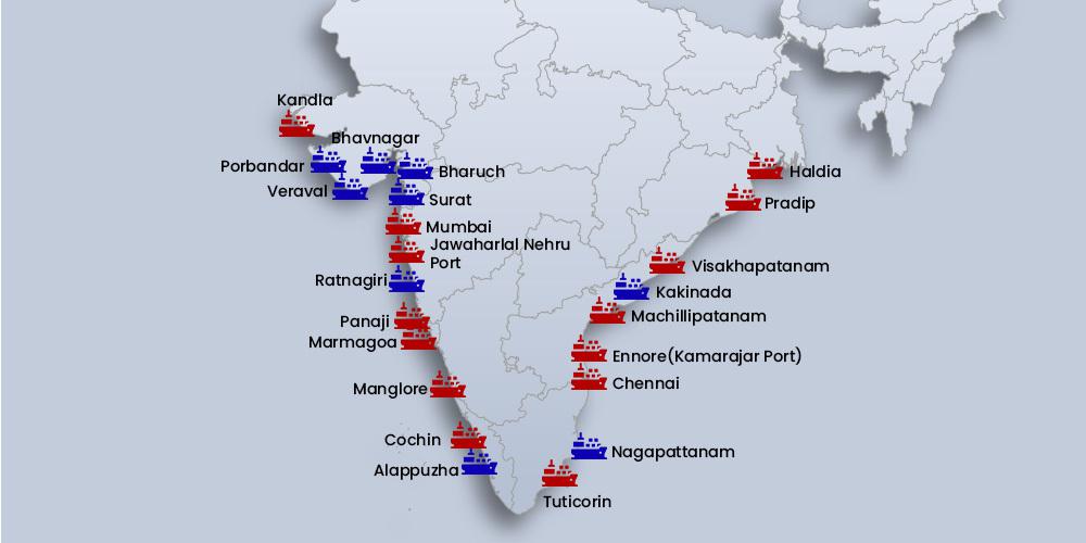
India, being a peninsula, is very rich in coastal regions. India has 6100 km of primary coastline, making up roughly 7500 km of overall coastline. There are numerous natural, artificial, and tidal ports in these coastal regions, which are spread across India’s nine coastal states. Of these, 13 major, 200 intermediate, and minor ports help with sea transportation and manage a significant amount of traffic and sea trades.
Major Sea Ports in India On the Eastern Coast
- The Eastern coastal plains of India lie between the Eastern Ghats and the Bay of Bengal. It extends through Tamil Nadu, Andhra Pradesh, Orissa, and West Bengal.
- It is further divided into three coasts – the Coromandel coast, the Andhra coast, and the Utkal coast.
- The major ports of India located in the Eastern Coastal plains are as follows.
- Kolkata Port
- Paradip Port
- Visakhapatnam Port
- Kamarajar Port
- Chennai Port
- Tuticorin Port
Kolkata Port
- The Kolkata port, officially known as the Syama Prasad Mookerjee Port, is in Kolkata, West Bengal.
- The Kolkata port is the oldest in the Country. The British East India Company constructed it and played a crucial role in trading during the colonial period.
- Among the 12 major ports of India, it is the only riverine port, and ships up to a length of 500 feet can be accommodated comfortably here.
- This port has a twin dock system – Haldia dock and Kolkata dock. The Haldia dock is located on the Western bank of River Hooghly whereas the Kolkata dock is on the Eastern bank of River Hooghly.
- It is one of the busiest essential ports in India, and it is a major exporter of iron ore, leather, coal, copper, steel, and tea.
Paradip Port
- Paradip port is located in the Jagatsinghpur district of Odisha, the only major port in Odisha.
- It is constructed at the confluence of River Mahanadi and the Bay of Bengal.
- In 1966, it was declared the eighth major port of India, and it was the first major port on the east coast of India to be commissioned after independence.
- Iron ore and coal are the components that are majorly transported at this port.
Visakhapatnam Port
- Visakhapatnam port, also known as the Vizag port, is located in the city of Visakhapatnam, Andhra Pradesh. It is between the Chennai port and Kolkata port.
- It is a natural harbor port and one of the country’s oldest ports.
- It is the most profound and safest landlocked port in India.
- Regarding cargo handling, Vizag port is the second largest port in the country.
- The port consists of three harbors – inner harbor, outer harbour and fishing harbour.
- Iron ore, oil, coal, alumina, and pellets are some of the major goods which are transported in the Vizag port. Most of the iron export of the country is handled here.
Kamarajar Port (Ennore Port)
- Kamarajar Port, formerly the Ennore port, is 24km north of Chennai port.
- It is the first corporate port in India and is the only corporatized major port in India. It was declared the 12th major port of the country.
- This port is registered as a public company, and the Government of India owns 67% of its stake.
- Coal is being transported at a large scale in Kamarajar port. It also deals with iron ore, petroleum products, etc.
Chennai Port
- The Chennai port, earlier known as Madras Port, is the second largest container port in the country and is credited as the largest port in the Bay of Bengal.
- It is an artificial port. It was opened in 1881, which makes it the third oldest port in India.
- In 1983, it was made the first dedicated container terminal in India.
- Goods such as automobiles, iron ore, coal, granite, petroleum products, and fertilizers are traded on a large scale at this port.
Tuticorin Port
- The Tuticorin port, also known as the V.O.Chidambaranar port, is located in the Thoothukudi district of Tamil Nadu.
- It is the fourth-largest container terminal in the country and the second-largest port in Tamil Nadu.
- It is an artificial port that mainly trades goods to and from Sri Lanka.
- On completion of the Sethusamudram shipping canal project, which intends to create a shipping route in the shallow straits between India and Sri Lanka, the Tuticorin port will become the premier port of India.
- This port is known for its pearl fishery in the Bay of Bengal.
- Goods such as coal, oil, sugar, salt, petroleum products, etc., are traded at this port.
Major Sea Ports in India on the Western Coast
- The Western coastal plains of India extend from Gujarat in the North to Kerala in the South, passing through the states of Maharashtra, Karnataka, and Goa. It lies between the Western Ghats and the Arabian Sea.
- It is further divided into four coasts:
- Kachchh and Kathiawar coast,
- Konkan coast,
- Kanara coast and,
- Malabar coast.
- The major ports located on the western coasts of India are as follows.
- Kandla Port
- Jawaharlal Nehru Port
- Mumbai Port
- Mormugao Port
- New Mangalore Port
- Cochin Port
Kandla Port
- The Kandla Port, known as Deendayal port, is located in the Kutch district of Gujarat. It is situated 90km away from the Gulf of Kutch.
- Based on the volume of cargo handled, Kandla port is the largest port in India. It is also one of the busiest ports in the country.
- Kandla port has been declared a trade-free zone.
- Food grains and oils are exported and imported in large quantities at this port, respectively. Additionally, machinery, petroleum products, salts, chemicals, and textiles are handled at this port.
Jawaharlal Nehru Port
- Jawaharlal Nehru port is also known as the Nhava Sheva Port. It is located in the Raigad district (Navi Mumbai) of Maharashtra.
- It is India’s largest container handling port and takes about 56% of containers in the country. It is one of the busiest seaports.
- Goods such as textiles, boneless meats, carpets, pharmaceuticals, machinery, chemicals, and vegetable oils are transported via this port.
- The Western dedicated freight corridor, constructed by the Indian Railways, is located in this port.
Mumbai Port
- The Mumbai port, or Bombay port, is located in Maharashtra. It is a natural port.
- It is the largest port in India and one of the country’s oldest ports.
- Mumbai port is the busiest port in the country, handling about one-fifth of the country’s total export.
- Jawahar Dweep is an island in the harbor with four jetties (a long narrow structure protecting the coastline from tides and currents) to handle crude and petroleum products.
- It has three dock facilities – Prince’s, Victoria, and Indira.
Mormugao Port
- Mormugao port is located in the estuaries of River Juari in the state of Goa.
- Mormugao port is one of the tourist destinations of Goa.
- This port is the leading iron ore export port in India. Apart from iron ore, goods such as cotton, manganese, and coconut are handled at this port.
New Mangalore Port
- The New Mangalore port is situated at Mangalore in Karnataka. It is located at the confluence of River Gurupura and the Arabian Sea.
- It is the country’s seventh largest port and the only major port located in Karnataka State. It is also the deepest inner harbor port on India’s Eastern coast.
- Petroleum products, LPG, fertilizers, and iron ore are some of the products handled at this port.
Cochin Port
- The Cochin port, also known as the Kochi port, is situated between Willingdon island and Vallarpadam island in the Lake of Kochi.
- The International Container Transshipment Terminal, also known as Vallarpadam terminal, was the first transhipment terminal in India and the largest container shipment facility in the country. This facility is a part of the Cochin port.
- It is one of the largest ports in the country and also one of the shipbuilding centers in India.
- The Kochi port mainly deals with importing and exporting coffee, tea, spices, salts, fertilizers, etc.
Port Blair
- Port Blair Trust is a seaport in Andaman and Nicobar.
- Located on the Andaman Sea, it is one of the major ports in India.
- Port Blair Port Trust operates the port. With this, Port Blair becomes the 13th major port in India and the only major port in Andaman and Nicobar.
States with the Majority of Ports in India
The nine coastal states of India viz. Kerala, Karnataka, Maharashtra, Goa, Gujarat, West Bengal, Odisha, Andhra Pradesh, and Tamil Nadu are home to the country’s ports.
- Tamil Nadu has three major ports and tops the list of Indian states with the most important ports. The three main ports in this state are Chennai Port, Kamarajar Port, and V. O. Chidambaranar Port Trust.
- By taking both the primary and intermediate ports in the country into consideration, Maharashtra stands at the top, with Gujarat at the second position; next comes Tamil Nadu and is followed by Karnataka.
Private Ports in India
- Major ports held by the government for a long time had complete control over India’s maritime trade. A new era for the nation’s port industry began when a partnership led by P&O Australia (now DP World) began trialing a container terminal at Jawaharlal Nehru Port (JNP) in Mumbai.
- The primary container handling port in India, JNP, now has three container terminals, of which private companies run two.
- Nearly 85–90% of India’s EXIM trade went through the ports the state-operated up until the turn of the last century. Private docks are more significant in India’s EXIM commerce than container freight. Even in the area of bulk cargo, their contribution is constantly increasing.
- Unfortunately, these ports were noted for their congested roads, poor cargo clearance, outdated machinery, handling techniques, labor problems, lethargic decision-making, etc.
- To address some of these issues, the central government decided to start private engagement in the major ports just after the liberalization measures of the early 1990s. As a result, instead of handling just 10–15% of all EXIM cargo handled by India at the beginning of the millennium, private companies now take more than 50% of the business.
Mundra Port – The Largest Private Port in India
The Port of Mundra is a special economic zone and India’s biggest private port. It was formed in 1998 under Gujarat Adani Port Limited (GAPL) and commenced operations in 2001. Mundra Port and Special Economic Zone Limited was the new name of the combined firm.
Cultural realm is a geographical region where cultural traits maintain homogeneity. The cultural traits are supposed to be the product of regional geographical circumstances. It is, thus, regional geography which has become the basis of the delineation of cultural realms in the world. Ratzel‘s concept of cultural landscape provided encouragement to geographers for culture regionalization.
Blache and Spencer are other geographers who considered the study of cultural realms as an important part of human geography. Apart from the geographers, historians, anthropologists and sociologists have also tried to regionalize the world into cultural realms. The variables of culture include the economic organization, social customs, traditional values, dietary habits, dress patterns, language and uniformity in physical characteristics. On the basis of these variables, various cultural realms can be identified.
Brock Webb tried to establish the dominance of a particular phenomenon over the evolution of cultural landscape. He found that the impact of religious values is tremendous over the entire cultural system. All over the world, human beliefs, day-to-day activities and even dress patterns, food habits and social values are influenced by religious messages. To many geographers, religious messages are also influenced by regional geography. A cultural religious investigation reveals that the culture of a particular region becomes ineffective once the religious impact is withdrawn. Considering these phenomena, Brock Webb divided the world into four major and two minor cultural realms. The major cultural realms are Occidental Realm, Islamic Realm, Indian Realm, East Indian Realm and the minor cultural realms are South-East Asian Realm, Meso- African or Negro African Realm.
Major Cultural Realms of the World
1. Occidental Culture
(i) West European
(ii) Continental European
(iii) Mediterranean
(iv) Anglo American
(v) Australian
(vi) Latin American
2. Islamic Culture
3. Indic Culture
4. South East Asian Culture
1. Occidental Realm
Occidental culture is the culture of the European society. It is influenced to a great extent by Christianity. It has regional modifications on the basis of varying levels of industrialisation, political and economic thought, colonisation, commercialisation, urbanisation, and development of transport system, land development of social, political and economic institutions.
In many parts of the occidental culture, the impact of non-religious factors, particularly the effect of modernisation, is so great that the religious values are side lined. Post-industrial Europe is fast emerging as a society where traditional values are nearly abandoned. The occidental culture covers a vast area. It is further divided into six sub-regions considering the impact of regional environment.
- West European is the most industrialized and urbanized culture
- Continental European culture is influenced by different political and economic thoughts, while Christianity remains an important influence.
- Mediterranean Europe includes countries lying to the south of the Alps. It is the region of dominance of Christianity. To many geographers, the deep-rooted traditional social system is the principal cause of limited economic development in countries like Spain, Portugal and southern Italy, compared to countries of northern and western Europe which adopted necessary changes in their social systems.
- Anglo-American and
- Australian cultural realms are practically the offspring‘s of west European culture. Both are inhabited by migrants from west Europe. There are only some regional differences.
- Latin American culture is very similar to the Mediterranean culture. It is the only region of occidental culture which lies in the tropics and is underdeveloped. It became a part of the occidental culture as a result of conversion of tribes into Christianity. The colonial languages, Spanish and Portuguese, have become the state languages. Regional architecture has been influenced by the Spanish and Portuguese styles.Ractically all countries maintain economic, cultural and social ties with the Mediterranean countries.
2. Islamic Cultural Realm
The culture here is influenced by Islamic values. It covers a vast geographical area from Morocco in the west to Pakistan in the east. The population is sparsely distributed due to inhospitable environment. The coasts, river basins and oases have been the cradles of Arabian culture in this realm. The British call it the Middle-East while the Germans call it a “Region of oriental culture”. This cultural realm lies between the traditional Indian culture in the east and the modernized European culture in the west.Islamic culture is highly orthodox and based on traditional beliefs, the impact of which can be seen in high female illiteracy rates. These countries have very high per capita incomes, but the level of modernization is very low.
3. Indic Cultural Realm
This is the culture of the Indian sub-continent. Baker called it a sub- continental culture, while D. Stamp used the term paddy culture. This cultural realm is welldefined; it lies between Himalayas in the north and Indian Ocean in the south. This cultural realm is characterized by joint family, village community, caste system, semi- feudal land relations, subsistence agriculture, paddy farming, seasonal climate changes and agricultural season coming at the same time all over the region. The culture of this region is greatly influenced by Vedic values. Though the region is inhabited by various communities, the social system has the hidden impact of Vedic cultural values.
4. East Asian Culture
This culture is basically a Buddhist culture with regional modifications. True Buddhist culture can be seen in South Korea and Japan. Even these two countries have felt the impact of industrialization, urbanization and modernization. The culture of mainland China has modified the Buddhist system. This culture was adopted after the Second World War.
The objectives of human geography revolve around understanding the relationships between human societies and the physical world. Human geography aims to explore how humans interact with, modify, and organize space and place and how these spatial dynamics impact societies, economies, and the environment. Here are the key objectives:
Analyzing Human-Environment Interaction
- One of the primary objectives is to understand how humans influence and are influenced by their natural surroundings. Human geography examines how geography affects lifestyles, settlement patterns, resource use, and how human activities, in turn, shape and sometimes alter the physical environment.
Studying Spatial Organization and Patterns
- Human geography seeks to analyze the spatial distribution of populations, cultures, economic activities, political territories, and more. It aims to identify and explain patterns and trends in where people live, work, and move, and how these patterns affect social and economic interactions across regions.
Understanding Cultural Landscapes and Place-Making
- Human geographers study how human cultures and societies give meaning to landscapes, creating unique “cultural landscapes.” This involves examining how people modify spaces (e.g., urban development, agricultural landscapes) and how different places hold symbolic and cultural significance for communities.
Examining Population Dynamics and Migration
- Human geography explores demographic trends, such as population growth, density, age structure, and migration. It examines the reasons behind migration patterns, the effects of population pressures on resources, and how demographic changes impact social and economic structures.
Exploring Economic Geography and Resource Distribution
- Understanding how economic activities are distributed spatially is crucial. Human geography analyzes the distribution of industries, agriculture, and services, and the flow of goods and services across regions. This includes studying global trade, economic inequality, and access to resources.
Investigating Political Geography and Territoriality
- Another objective is to understand the spatial dimensions of political processes, including the organization of political boundaries, the role of nation-states, and the spatial dynamics of power. This includes studying geopolitical relationships, territorial disputes, and the influence of political decisions on regions and communities.
Promoting Sustainable Development and Environmental Awareness
- Human geography aims to support sustainable development by studying the impact of human actions on the environment and promoting environmentally friendly practices. This includes researching urbanization, pollution, land use, and resource consumption, helping societies develop policies that balance economic growth with environmental protection.
Studying Social and Cultural Diversity
- An objective of human geography is to analyze the distribution and diversity of cultures, languages, religions, and social practices. It looks at how cultural identities are expressed in spaces and places and how these identities influence and are influenced by the physical environment.
Enhancing Spatial Decision-Making and Planning
- By providing insights into human-environment interactions and spatial patterns, human geography aids in spatial planning and decision-making. This includes urban planning, transportation networks, infrastructure development, and disaster management, aiming to create efficient, sustainable, and equitable spaces.
Understanding Globalization and Its Local Impacts
- Human geography studies the processes and effects of globalization, examining how global economic, cultural, and political forces shape local places and impact local economies, cultural identities, and social structures. This includes analyzing how local cultures respond to and are transformed by global trends.
Fostering Geographic Literacy and Awareness
- Finally, human geography aims to enhance geographic literacy, helping people understand the importance of space, place, and environment in their lives. By raising awareness of spatial dynamics, human geography encourages people to think critically about social, economic, and environmental issues on a local and global scale.
| Aspect | Rural Settlements | Urban Settlements |
|---|---|---|
| Population Density | Low population density; fewer people per square kilometer | High population density; many people per square kilometer |
| Land Use | Primarily agricultural, forestry, and other primary activities | Dominated by residential, industrial, and commercial land use |
| Size of Settlements | Small-sized settlements (e.g., villages, hamlets) | Large-sized settlements (e.g., towns, cities, metropolises) |
| Infrastructure | Limited infrastructure, fewer amenities and services | Advanced infrastructure, well-developed amenities and services |
| Lifestyle | Simpler, slower-paced lifestyle | Fast-paced lifestyle with more modern amenities |
| Employment | Mainly agricultural and resource-based jobs | Diverse employment opportunities in industry, business, services |
| Social Structure | More close-knit, community-oriented | Often more individualistic, socially diverse |
| Housing Patterns | Dispersed, often individual houses | Dense, with apartments, high-rise buildings |
| Transportation | Limited public transport, reliance on personal or shared vehicles | Extensive public transport systems, multiple transport options |
| Economic Activities | Predominantly primary (agriculture, fishing, mining) | Predominantly secondary and tertiary (manufacturing, services, finance) |
| Education and Health Facilities | Limited access to specialized facilities | Wide access to educational institutions and advanced healthcare |
| Environmental Impact | Generally lower environmental pollution | Higher levels of pollution and environmental challenges |
| Cultural Characteristics | Traditional and conservative lifestyle | Diverse and cosmopolitan lifestyle, exposure to global trends |
| Land Costs | Typically low | Generally high due to demand for limited space |
Shifting cultivation, also known as slash-and-burn or swidden agriculture, is a traditional farming practice that has been employed by various indigenous communities around the world, including India. This unique method of cultivation involves the rotation of cultivated plots in a cyclical manner, allowing the land to regenerate and maintain its fertility.
Shifting Agriculture
Shifting agriculture, also known as slash-and-burn or swidden farming, involves clearing land, burning vegetation, and cultivating crops for a limited time before moving to a new area. While traditional, it can lead to deforestation and soil degradation, posing challenges for long-term sustainability and biodiversity.
What is Shifting Agriculture?
Shifting cultivation is an agricultural technique where small areas of forest or brush are cleared and burned to create arable land for cultivation. The cleared land is used for farming crops for a few years until the soil’s fertility declines. Once this happens, the farmers abandon the plot and move on to clear a new area for cultivation, allowing the previously used land to regenerate naturally over time.
How is Shifting Agriculture Practiced?
Shifting cultivation is a multi-step process that involves several stages:
- Clearing and Burning: The first step involves clearing the chosen plot of land by cutting down vegetation and then burning it. This process releases nutrients into the soil and provides a fertile bed for planting.
- Cultivation: After burning, crops are planted in the nutrient-rich soil. Farmers typically grow a variety of crops including cereals, vegetables, and tubers.
- Harvesting: The crops are nurtured and harvested when they are ready.
- Fallow Period: Once the soil’s fertility decreases, the land is left fallow for several years to recover. During this time, natural vegetation regenerates, and the land gains back its fertility.
Characteristics of Shifting Agricultural
Shifting cultivation is characterized by its sustainable approach to land use. The practice promotes biodiversity and allows the land to rest and rejuvenate, ensuring its long-term productivity. It also fosters a strong connection between communities and their natural environment. Check out the list of characteristics of shifting cultivation in a list:
- Sustainable land use practice.
- Involves clearing and burning small plots of land.
- Utilizes fallow periods for natural land regeneration.
- Promotes biodiversity and ecological balance.
- Deeply rooted in the cultural heritage of indigenous communities.
- Relies on traditional knowledge and community cooperation.
- Provides diverse and nutritious crops.
- Enhances soil fertility through burning and organic matter.
- Adapts to local environmental conditions.
- Supports self-sufficiency and food security.
- Requires a deep understanding of local ecosystems.
- Balances cultivation with natural resource conservation.
Soil Related Constraints VS Climate Related Constraints in Shifting Cultivation
Shifting cultivation faces various challenges, both soil-related and climate-related. Soil erosion, loss of soil fertility, and decreased productivity are some of the soil-related constraints. On the other hand, changing weather patterns, unpredictable rainfall, and increased vulnerability to pests and diseases pose climate-related challenges to this practice. Check out the concerns in this detailed table below:
Soil-Related Constraints | Climate-Related Constraints |
Soil erosion and loss of fertility | Unpredictable rainfall patterns |
Reduced soil productivity | Increased vulnerability to pests and diseases |
Decline in nutrient levels | Altered growing seasons |
Loss of organic matter | Extreme weather events |
Soil compaction | Changing temperature patterns |
Nutrient imbalances | Droughts and water scarcity |
Types of Shifting Agriculture
There are several types of shifting cultivation practices based on regional and cultural variations. Some of these include swidden cultivation, milpa farming, jhum cultivation, and more. Each type adapts the basic principles of shifting cultivation to suit the specific needs of the community.
- Swidden Cultivation: Also known as slash-and-burn farming, it involves clearing and burning land to cultivate crops, followed by a fallow period for natural regeneration.
- Milpa Farming: A traditional Mesoamerican method where maize, beans, and squash are interplanted, using forest clearings and fallows.
- Jhum Cultivation: Practiced in Northeast India and Southeast Asia, it includes clearing land, growing crops, and allowing fallow periods for soil recovery.
- Taungya System: Combines tree planting with agriculture, helping reforest cleared land while growing crops.
- Roca Cultivation: Common in South America, it entails clearing small plots in forests for crops like cassava and plantains, followed by extended fallows.
- Ladang Farming: Found in Southeast Asia, it involves clearing land for cultivation and rotating crops with fallow periods.
- Conuco Farming: Utilized in the Caribbean, it features small-scale clearings for various crops, promoting biodiversity.
- Ray Cultivation: Practiced in the Amazon rainforest, it includes alternating planting and fallow phases to sustain crop yields.
- Kumara Cultivation: Traditional method in New Zealand, where kumara (sweet potato) is grown, allowing land regeneration.
- Chena Cultivation: Found in Sri Lanka, it involves slash-and-burn cultivation of upland rice and other crops, with longer fallows.
Importance of Shifting Agriculture
Shifting cultivation plays a crucial role in the lives of many indigenous communities. It allows them to maintain a sustainable livelihood while preserving their cultural heritage and traditional knowledge of the land. This practice also contributes to food security, as the diverse crops grown through shifting cultivation provide a varied and nutritious diet. Here are the complete factors of importance in this:
- Sustainable Land Use: Shifting cultivation maintains soil fertility and prevents land degradation through fallow periods and natural regeneration.
- Biodiversity Preservation: The practice promotes diverse crops and maintains local flora and fauna, contributing to ecosystem health.
- Cultural Heritage: Shifting cultivation is deeply rooted in indigenous traditions, preserving cultural identity and knowledge.
- Food Security: The variety of crops grown ensures a consistent and nutritious food supply for communities.
- Resilience to Climate Change: Adaptability of shifting cultivation helps communities cope with changing weather patterns and conditions.
- Local Self-Sufficiency: Communities can rely on their land for sustenance, reducing dependency on external sources.
- Economic Livelihoods: Shifting cultivation supports rural economies and provides income opportunities for indigenous communities.
- Reduced Deforestation: By rotating cultivated areas, shifting cultivation minimizes the need to clear new land, helping conserve forests.
- Soil Fertility Enhancement: Controlled burning and organic matter incorporation enrich soil nutrients and improve fertility.
- Knowledge Transfer: The practice fosters intergenerational knowledge sharing and community cooperation.
Shifting Agriculture Advantages and Disadvantages in a Table
Advantages | Disadvantages |
Promotes biodiversity | Soil fertility depletion |
Sustainable land use | Climate change impact |
Cultural preservation | Labor-intensive |
Food security | Deforestation |
Nutrient-rich soil | Vulnerability to external market fluctuations |
Regions that Use Shifting Cultivation in India
Shifting cultivation is prevalent in various regions of India, including:
- Northeastern States: Assam, Nagaland, Manipur, Mizoram, Meghalaya, Arunachal Pradesh, and Tripura.
- Central India: Jharkhand, Chhattisgarh, Madhya Pradesh, and parts of Odisha.
- Western Ghats: States like Kerala, Karnataka, and Maharashtra have indigenous communities practicing shifting cultivation.
- Andaman and Nicobar Islands: Indigenous groups on these islands have traditionally engaged in shifting cultivation.
- Eastern Himalayas: Sikkim and parts of West Bengal have communities practicing forms of shifting cultivation.
- Jammu and Kashmir: Some tribal communities in the state practice shifting cultivation in hilly areas.
- Tribal Belts: Various tribal belts across the country continue to use shifting cultivation methods.
The Indian Ocean has been a vital maritime highway for centuries, serving as a significant route for trade, cultural exchange, and strategic navigation. Spanning from the eastern coast of Africa to the western shores of Australia and bordered by Asia to the north and the Southern Ocean, the Indian Ocean is rich with sea routes that facilitate global commerce and connect diverse regions. The sea routes of the Indian Ocean are not only crucial for international trade but also play a critical role in the geopolitical landscape, connecting some of the fastest-growing economies in the world.
Historical Importance of Indian Ocean Sea Routes
Historically, the Indian Ocean was an early cradle of maritime trade. From ancient times, Arab, Persian, Indian, Chinese, and Southeast Asian merchants utilized these waters for the exchange of goods such as spices, textiles, metals, and precious stones. The Monsoon winds provided seasonal advantages, allowing traders to sail with ease, taking advantage of the winds to travel westward in summer and eastward in winter. This natural phenomenon gave rise to a thriving maritime Silk Route that linked the civilizations of Asia, the Middle East, and East Africa, fostering not only trade but also cultural and technological exchange.
In the Age of Exploration, European powers, notably the Portuguese, Dutch, and British, recognized the strategic importance of the Indian Ocean sea routes. Their control over these routes enabled them to dominate global trade, particularly in valuable commodities like spices, silk, and tea. The Indian Ocean routes thus became the backbone of colonial trade networks, and major ports such as Goa, Cochin, Mombasa, and Malacca emerged as central trading hubs.
Major Sea Routes in the Indian Ocean
Today, the Indian Ocean remains one of the busiest maritime corridors, hosting several critical sea routes that support both regional and global trade:
Strait of Malacca
- One of the most vital chokepoints in the world, the Strait of Malacca connects the Indian Ocean to the South China Sea and the Pacific Ocean.
- Approximately 80% of China’s oil imports and a significant percentage of global maritime trade pass through this narrow strait, making it indispensable for East Asian economies.
- Its strategic importance has led to heavy patrol and monitoring, as even minor disruptions could have global economic repercussions.
Bab-el-Mandeb Strait
- Located between Yemen on the Arabian Peninsula and Djibouti and Eritrea in East Africa, the Bab-el-Mandeb Strait is a key route that connects the Red Sea to the Gulf of Aden and the Indian Ocean.
- It serves as a gateway to the Suez Canal, facilitating trade between Europe, the Middle East, and Asia.
- This route is critical for the movement of Middle Eastern oil to European and North American markets, making it one of the world’s most crucial maritime chokepoints.
Hormuz Strait
- The Strait of Hormuz, situated between Iran and Oman, connects the Persian Gulf to the Arabian Sea and the broader Indian Ocean.
- It is a strategic passage for oil exports from the Middle East, as about 20% of the world’s petroleum passes through this narrow waterway.
- Any instability in this region can lead to significant fluctuations in global oil prices, highlighting its economic and geopolitical significance.
Mozambique Channel
- The Mozambique Channel, located between Madagascar and Mozambique on the southeastern coast of Africa, is an important route for vessels traveling between the Indian Ocean and the South Atlantic.
- This route is especially important for African exports, including minerals, oil, and agricultural products.
- Recent discoveries of oil and natural gas in the region have increased its importance as a strategic and economic asset.
Western Indian Ocean Routes
- The Western Indian Ocean routes link the Middle East with the eastern coast of Africa and the Indian subcontinent.
- These routes support trade in oil, consumer goods, and manufactured products between Asia and Africa.
- Ports along this route, such as Dubai, Mumbai, and Mombasa, serve as critical hubs for transshipment and regional trade.
Geopolitical Significance of Indian Ocean Sea Routes
The Indian Ocean sea routes are strategically significant, as they connect major economic regions and supply vital resources like oil and natural gas to global markets. China, India, the United States, and Japan have strong interests in maintaining security in the Indian Ocean due to their reliance on these routes for energy imports and exports. This has led to a rise in naval presence and military bases in the region, with countries like the United States, India, and China establishing military installations near critical chokepoints to ensure secure and unimpeded passage for their maritime interests.
The development of human geography represents a significant evolution in our understanding of the relationship between human societies and their environments. Human geography, as a branch of geography, focuses on the spatial aspects of human activities, including settlement patterns, economic practices, culture, and politics. Over time, this field has grown from a descriptive study of places to a sophisticated, analytical discipline that seeks to explain the complex interactions between people and the spaces they inhabit.
Early Beginnings: Exploration and Description
The foundations of human geography can be traced back to ancient civilizations like Greece, Rome, and China, where early geographers such as Herodotus, Ptolemy, and Strabo compiled information about the world’s various peoples, regions, and physical landscapes. Ancient geographers were primarily concerned with describing the cultural and physical characteristics of different regions, often driven by the expansion of empires and trade routes. Descriptive accounts of far-off lands and people were central to early human geography, but these accounts lacked analytical depth.
During the Age of Exploration (15th to 17th centuries), European explorers like Christopher Columbus, Vasco da Gama, and Ferdinand Magellan expanded geographical knowledge by mapping new lands and documenting indigenous cultures. This period of exploration fueled a deeper interest in the human-environment relationship, leading to the development of maps and geographic descriptions that laid the groundwork for systematic studies of cultural and regional diversity.
Emergence of Environmental Determinism
In the late 19th and early 20th centuries, human geography evolved to include more systematic approaches. One of the first major theoretical approaches to emerge was environmental determinism, a perspective that argued that human behaviors, cultures, and societal development are largely determined by the physical environment. Geographers like Friedrich Ratzel and Ellsworth Huntington advocated this theory, suggesting that climate, landforms, and natural resources play a dominant role in shaping societies.
Environmental determinism was influential in linking human development to geographic conditions, but it was criticized for being overly simplistic and ethnocentric, often justifying colonial ideologies by implying that certain environments were “superior” for human development. As a result, this theory began to lose prominence, and geographers started seeking more complex explanations for human activities and spatial organization.
Shift to Possibilism and Regional Geography
In response to the limitations of environmental determinism, possibilism emerged as a counter-theory. Possibilism, championed by French geographer Paul Vidal de la Blache, argued that while the environment sets certain constraints, human agency and cultural factors allow societies to make choices and adapt to diverse conditions. This shift emphasized the role of human creativity, innovation, and adaptation, suggesting that societies are not passively shaped by their environment but have the capacity to modify and transform it.
Alongside possibilism, regional geography gained prominence as a way to study places and regions as distinct entities with unique cultural and environmental characteristics. Regional geographers focused on describing and analyzing cultural landscapes, examining how human activity shapes and modifies the natural landscape. This approach highlighted the diversity of human societies and emphasized the importance of studying specific regions to understand the complexity of human-environment interactions.
Quantitative Revolution and Spatial Analysis
In the mid-20th century, human geography experienced a major transformation known as the Quantitative Revolution. This movement introduced statistical methods, mathematical models, and spatial analysis to human geography, aiming to make the field more scientific and objective. Geographers began using quantitative techniques to study spatial patterns of phenomena such as urbanization, migration, transportation, and economic activities. This shift toward a positivist approach sought to uncover general laws and patterns governing human behavior and spatial organization.
The central place theory by Walter Christaller and location theory by Alfred Weber are examples of theoretical models that emerged during this period, attempting to explain the spatial distribution of cities, industries, and services. The Quantitative Revolution had a lasting impact on human geography, laying the groundwork for geospatial technologies and data-driven approaches that are widely used today.
Rise of Humanistic and Behavioral Geography
In the 1970s, the limitations of quantitative approaches led to the emergence of humanistic and behavioral geography, which emphasized the importance of human experience, perception, and decision-making. Humanistic geography focused on individuals’ relationships with places, exploring concepts such as sense of place, attachment, and identity. This approach, led by geographers like Yi-Fu Tuan and Edward Relph, emphasized the subjective aspects of human geography, suggesting that people’s perceptions and emotions shape their interactions with places.
Behavioral geography sought to incorporate psychological insights into human geography, analyzing how people make spatial decisions based on cognitive processes. For example, studies of mental maps and spatial behavior revealed that people’s perceptions of distance and accessibility often differ from objective measurements, impacting their movements and choices. This approach added depth to human geography by acknowledging the role of individual psychology in shaping spatial behavior.
Marxist, Feminist, and Postmodern Approaches
From the 1980s onward, human geography became increasingly critical and interdisciplinary, incorporating ideas from Marxism, feminism, and postmodernism. Marxist geography, influenced by David Harvey, examined issues of inequality, class, and power within spatial contexts, exploring how capitalist systems shape cities, economies, and social relations. This approach highlighted the economic structures and power dynamics that influence spatial organization, providing insights into issues like urban poverty, gentrification, and globalization.
Feminist geography emerged as a critique of male-dominated perspectives in geography, advocating for the inclusion of women’s experiences and gendered analyses in spatial studies. Feminist geographers highlighted how gender shapes access to spaces, labor, and resources, drawing attention to issues of inequality and representation in both urban and rural environments.
Incorporating postmodern thought, human geography also began exploring the diverse, fragmented nature of contemporary societies. Postmodern geographers argue that place and identity are fluid and constructed, emphasizing cultural diversity, local narratives, and the subjective nature of human experience. This approach has led to more nuanced studies of culture, identity, and globalization, recognizing the multiple meanings people attach to spaces and places.
Modern Human Geography and Its Applications
Today, human geography is a dynamic and interdisciplinary field that addresses some of the most pressing global issues. Globalization, climate change, urbanization, and social justice are central themes in modern human geography, with geographers applying insights from various theoretical approaches to understand these challenges. The use of geospatial technology, Geographic Information Systems (GIS), and remote sensing has revolutionized data collection and analysis, allowing geographers to study spatial phenomena with unprecedented precision.
Urban planning, environmental management, migration studies, and health geography are among the many areas where human geography plays a vital role. By analyzing the spatial dimensions of issues like resource distribution, environmental justice, and public health, human geographers contribute to sustainable development and policy-making that address human needs and environmental constraints.
A megalopolis or a supercity, also called a megaregion, is a group of metropolitan areas which are perceived as a continuous urban area through common systems of transport, economy, resources, ecology, and so on.They are integrated enough that coordinating policy is valuable, although the constituent metropolises keep their individual identities.[2] The megalopolis concept has become highly influential as it introduced a new, larger scale thinking about urban patterns and growth.
Sawah cultivation is a traditional method of rice farming practiced primarily in Southeast Asia, especially in countries like Indonesia, the Philippines, Vietnam, and Thailand. In sawah cultivation, rice is grown in flat, flooded fields known as “paddies,” which are designed to retain water through embankments around the fields. This flooded environment is ideal for rice, as it suppresses weeds and provides a continuous water supply, which is essential for the plant’s growth.
Sawah fields are often terraced on hillsides to make use of sloped land, allowing water to flow gradually from one level to the next. The method involves intensive labor, requiring careful preparation, transplanting of seedlings, and frequent management of water levels. While labor-intensive, sawah cultivation is highly productive, supporting dense populations in the regions where it is practiced. This system has been sustainable for centuries, as it promotes soil fertility and supports high yields of rice, a staple food for millions.
In human geography, the term “Negro” has been used historically within academic literature to study and describe populations of African descent and their spatial distribution, migration patterns, and cultural practices. However, this term is now recognized as outdated and offensive, largely due to its associations with colonialism, racial discrimination, and segregation.
Modern human geography has shifted to more respectful and accurate terminology, such as “Black,” “African American,” or “Afro-descendant,” which acknowledges and honors individuals’ cultural identities and histories. Current studies in human geography focus on understanding the African diaspora’s contributions, cultural landscapes, and experiences within urban spaces, migration flows, economic development, and the impact of systemic inequalities on African-descendant communities worldwide. This shift not only updates language but also reframes the approach to be more inclusive and sensitive to the social and historical complexities involved.
The Pygmies are indigenous groups traditionally known for their small physical stature, primarily inhabiting the dense tropical rainforests of Central Africa. These communities include groups like the Aka, Baka, Mbuti, and Twa, who live in regions across countries like the Democratic Republic of Congo, Rwanda, Uganda, Cameroon, and the Central African Republic. The term “Pygmy” itself is sometimes considered pejorative, so “forest peoples” or specific group names are often preferred.
Historically, Pygmy groups are known for their hunter-gatherer lifestyle, relying on the forest for food, medicine, and shelter. Their knowledge of the forest ecosystem is extensive, enabling sustainable practices in hunting and gathering that maintain biodiversity. Many of these groups practice a semi-nomadic lifestyle, moving within the forest as seasonal conditions change, although some have adapted to more sedentary lives due to external pressures.
In recent years, Pygmy communities face challenges such as deforestation, forced displacement, and discrimination. As forests are cleared for logging, agriculture, and mining, these groups lose access to traditional lands, threatening their way of life. Human geographers and anthropologists work to understand their unique relationship with the environment, the impacts of modernization, and the importance of preserving their cultural and ecological knowledge.
The concept of cultural diffusion refers to the spread of cultural elements—such as beliefs, practices, technologies, and languages—from one region or group to another. In human geography, this process is essential for understanding how societies evolve and how cultural traits permeate across boundaries.
Cultural diffusion occurs through various mechanisms. One of the most prominent is relocation diffusion, where individuals or groups migrate to new locations, carrying their cultural practices with them. For example, the migration of Indian and Chinese laborers during the 19th and early 20th centuries spread cuisines, languages, and religious practices to regions in Southeast Asia, the Caribbean, and Africa. Another form is expansion diffusion, where an idea or practice spreads outward from a central point. This diffusion often takes place through contagious diffusion, like the spread of popular music styles, or hierarchical diffusion, where trends move through a structured order (e.g., from cities to smaller towns).
A notable example of cultural diffusion is the global influence of American culture. Through mass media, such as films, music, and television, American cultural elements have permeated diverse regions, shaping everything from fashion trends to lifestyle choices. Likewise, the spread of fast food chains such as McDonald’s and KFC exemplifies cultural diffusion by bringing Western dining practices to places as diverse as Japan, India, and the Middle East.
Another aspect is technology-driven diffusion, especially with the rise of the internet and social media, which allows instant communication across the globe. This virtual interaction has facilitated the rapid spread of ideas, whether it’s through social media challenges, memes, or global activism movements like climate change awareness and gender equality advocacy.
However, cultural diffusion is not without resistance. Many societies face the challenge of preserving traditional practices and languages in the face of foreign influences. This tension between global influences and local traditions is a critical area in human geography, underscoring how globalization influences cultural identity.
Huntington divided human geography as (i) physical conditions and (ii) human responses.
In his book, “The Clash of Civilizations,” Samuel Huntington divides human geography into two categories: physical conditions and human responses. The physical conditions refer to the natural environment, including climate, topography, and resources, while human responses refer to the cultural and social factors that shape how people interact with and adapt to their physical environment.
Human Responses refer to the cultural and social factors that shape how people interact with and adapt to their physical environment. This includes:
1. Culture: The beliefs, values, and behaviors of a society that are transmitted from generation to generation.
2. Politics: The ways in which power is distributed and exercised within a society, including the role of government and other institutions.
3. Economics: The production, distribution, and consumption of goods and services within a society.
4. Social Organization: The ways in which people are organized into groups, such as families, communities, and nations.
By understanding these factors, we can better understand how societies interact with their physical environment and how they respond to changes in their environment. This is important for a variety of reasons, including environmental management and sustainability, disaster response, and the preservation of cultural heritage.
Rural to Urban migration is the most popular internal migration usually concentrated in less developed countries. In developed countries its a different story, urban to urban and urban to rural is more pronounced.
These migrations are not forced rather they’re voluntary. Rural to urban migration is one of the major cause behind urbanisation with natural increase.
Factors and Causes of Rural Urban Migration
Economic reasons
Most people move from rural to urban areas for economic reasons. Economic factors range from jobs to cheap goods and services. Because paying jobs are limited in rural areas, most rural dwellers are forced to seek jobs in urban areas.
Most jobs in rural areas will usually be for self or family sustenance such as subsistence farming which only bring food but rarely money. Money is needed for health services, education and buying goods, thus rural dwellers are forced to migrate to urban areas in search of paying jobs
The Green Revolution which began in the 1950s brought about a change in agriculture. New technology through the use of machines replaced rural people who already worked in farms. Thus with no jobs, people were forced to migrate to urban areas to look for jobs. The Green Revolution had a major impact concerning employment in countries such as India and China.
Many Indians were forced to migrate to cities which led to the eventual flooding of people in urban areas.
Education
Limited schools in rural areas force people to migrate to urban areas where there’s quality education although majority fail to afford this education.
Health Services
Again, health centers are very few in rural areas, people will have to walk tiresome journeys to get to the nearest health center and some barely make it alive. Even if people make it, the clinics will barely have quality health facilities and adequate medicine. This forces people to migrate urban where there’s abundant health centers and medicine.
Hazards and Famines
Most rural dwellers settle near hazardous areas in search of minerals and greener pastures. As such, when phenomenons such as volcanoes or earthquakes occur these people are displaced and have nowhere else to go but urban areas. When Mt Pinatubo (Philippines) erupted in 1991 displaced people were moved to the city Angeles.
Politics and Wars
Rural dwellers may be forced to migrate urban due to political issues such as wars or terrorism.
The above factors mostly force rural people to move urban. However, pull factors can also cause rural-urban migration. NB: Factors such as job or education seeking maybe forced or pulled
Psychological Mindset
Often rural people talk about and admire the Bright Light and entertainment of the city which can actually pull them to migrate into the city; they see the city as a paradise.
Personal Contact
Rural people who have successfully settled and are enjoying urban life can contact and encourage their friends or relatives remaining in rural areas to also settle in the urban area.
Visits
Rural dwellers can visit their friends or relatives in urban areas. Although temporary, some can stay permanently.
Effects of Rural Urban migration
The most noticeable impact of rural urban migration is urbanisatiom which is the increase of urban dwellers. When the city is filled with a huge number of people, many problems arise:
Growth of Shanties
Because some migrates fail to get proper jobs in urban areas, lack of money forces them to build illegal settlements called shanties. These settlements will often be built using poor and cheap materials such as plastics and card boxes.
In addition, these settlements will be built on land not allowed or recommended to be built on; for example in Brazil shanties called favelas are built on mountain slopes and in India shanties can be located around the heart of the city such as Mumbai.
Moreover, these settlements are manifested by poverty and diseases such as cholera due to poor sanitation. Millions of dollars are wasted trying to improve the quality of these settlements.
Increase in Crime Rate
Lack of jobs forces some migrates to deal in illegal activities such as theft, drugs and prostitution.
The Environment
The increase in people hence pollutive activities result in the development of urban heat islands. This results in high temperatures, abnormal rainfalls and the weather in general.
Urban Morphology refers to the study of the physical form and structure of cities. It’s an amalgamation of insights from various disciplines including geography, architecture, planning, and social sciences. By evaluating the interplay between the built environment and socio-economic forces, urban morphology elucidates patterns and processes shaping the spatial configurations of cities.
In essence, this discipline acts as a microscope that magnifies our understanding of the urban fabric — the street patterns, the building designs, the public spaces, and more. It’s through this intricate lens that we can perceive the dynamism of urban evolution and reinterpret the cityscape in the light of the past, the present, and the future.
History of Urban Morphology: Tracing the Evolution of Urban Studies
Delving into the study of urban morphology is akin to embarking on a fascinating journey through time. By understanding the genesis and progression of this discipline, we not only gain valuable insights into the foundations of our modern cities but also acquire a robust framework to comprehend their present intricacies and future trajectories.
Urban morphology, as a distinct field of study, first germinated in the late 19th and early 20th centuries. However, the underpinnings of the discipline trace back to ancient civilizations. The planned cities of the Harappan civilization, the gridiron plan of Roman cities, or the organically evolved medieval cities — all reflect an implicit understanding of what we now recognize as principles of urban morphology.
In the modern academic landscape, two schools of thought emerged predominantly in the study of urban morphology – the Italian school, led by Saverio Muratori, and the British school, steered by M.R.G Conzen. While the Italian school focused on the historical fabric of the cities and viewed the city as a living organism, the British school, on the other hand, emphasized the geographical aspects of urban development, analyzing the patterns of land use and building forms over time.
In the 20th century, urban morphology experienced a renaissance as urban issues gained prominence against the backdrop of rapid urbanization and industrialization. The discipline began to incorporate insights from related fields such as sociology, economics, and environmental science, evolving into an interdisciplinary domain.
Today, the field of urban morphology continues to be an essential pillar of urban studies, contributing significantly to the sustainable planning and development of our cities. By understanding its history, we can appreciate the rich tapestry of influences that have shaped it and leverage its lessons to forge a brighter urban future.
Elements of Urban Morphology
Underneath the surface complexity of the urban landscape are fundamental building blocks, the primary elements of urban morphology. Each element represents a different facet of a city’s physicality and functionality.
- Streets: The arteries of a city, defining connectivity and accessibility.
- Blocks: Defined by the network of streets, they house diverse urban activities.
- Buildings: From residential homes to towering skyscrapers, they shape the city’s skyline and define its character.
- Open Spaces: Public spaces like parks and plazas, contributing to a city’s livability.
- Land Use: Defines the distribution of various activities such as residential, commercial, industrial, and so on.
By closely studying these elements, we can unravel the urban structure, pinpoint its strengths and weaknesses, and work towards creating more livable, sustainable cities.
Different Types of Models in Urban Morphology: Unraveling Urban Patterns
The study of urban morphology involves deciphering the city’s form and structure. But given the complexity and diversity of cities, is there a unifying framework or model that we can use? Thankfully, urban morphology offers several models that encapsulate typical patterns of urban development. Let’s delve into some of the key models that help us understand and predict the spatial form and growth of cities.
- Concentric Zone Model: Proposed by sociologist Ernest Burgess in 1925, this model visualizes the city as a series of concentric circles radiating from a central business district (CBD). The model highlights the influence of socio-economic factors on the spatial organization of cities.
- Sector Model: Developed by Homer Hoyt in 1939, this model portrays cities as pie-shaped sectors radiating from the CBD. According to Hoyt, certain areas of a city are more attractive for various uses, leading to a sectoral distribution of similar land uses.
- Multiple Nuclei Model: Harris and Ullman’s 1945 model suggests that cities develop around several nodes or nuclei, each with its own specialty. These could be a CBD, a university, an industrial park, or a residential suburb.
- Urban Realms Model: Proposed by James Vance in 1964, this model describes the city as a collection of self-sufficient, semi-independent ‘realms,’ each with its own economic, social, and political entity.
- Bid-Rent Theory: This model, developed by William Alonso in 1964, explains the spatial organization of cities based on economic theory. It postulates that land values decrease as one moves away from the CBD, impacting the location of different land uses.
- Edge City Model: Garreau’s 1991 model recognizes the significance of suburban nodes. The ‘edge cities’ are described as a major concentration of retail and office space situated on the periphery of older urban areas.
It’s important to remember that while these models provide a simplified representation of urban morphology, they may not fully encapsulate the unique complexities of every city. Urban morphology is an evolving field, continually adapting to the changing dynamics of urban development. However, these models still serve as valuable tools, helping us analyze, interpret, and envision the urban landscape.
Shape and Structure of Urban Areas: Architecting the Urban Landscape
A distinctive aspect of urban morphology lies in its examination of the shape and structure of urban areas. This feature embodies the patterns and forms that lend cities their unique physical identity. Grasping this aspect is pivotal to understanding the nature and character of cities.
Urban Shape
Urban shape refers to the overall form or outline of an urban area. It is an overarching parameter that provides a bird’s-eye view of the city. Shapes of cities have been influenced by various factors over the course of history: topographical constraints, technological advancements, socio-cultural evolution, and economic factors.
Cities can be classified into several typical forms based on their shape:
- Linear Cities: These are stretched along a line, often a river, coast, road, or railway. An example is the Nile Valley in Egypt.
- Star-shaped Cities: These cities grow radially from a central point, like spokes on a wheel. Paris, with its boulevards radiating from the Arc de Triomphe, is a classic example.
- Circular or Ring Cities: These are shaped around a central core. The Ringstrasse in Vienna reflects this pattern.
- Gridiron Cities: Characterized by a network of perpendicular streets, these cities were prevalent in ancient Rome and later adopted in many American cities like New York.
- Organic Cities: These have evolved gradually over time, often with winding streets and irregular patterns. Many medieval European cities, such as Venice, show this characteristic.
Urban Structure
Urban structure refers to the internal layout or arrangement of different components within a city. It captures the organization of land use, the layout of streets, the arrangement of buildings, and the distribution of open spaces.
Understanding the structure of urban areas involves studying:
- Street Patterns: This includes grid patterns (as in Manhattan), radial patterns (as seen in Moscow), or irregular patterns (as found in many ancient cities).
- Building Patterns: How are buildings arranged? Are they densely packed, or is there significant open space? Are they low-rise or high-rise?
- Land Use Distribution: This pertains to the spatial allocation of residential, commercial, industrial, and recreational zones.
- Transportation Network: The layout and connectivity of roads, railways, airports, and ports define the accessibility and mobility within a city.
By studying the shape and structure of urban areas, urban morphology provides a blueprint of the city. It lays bare the inherent logic of urban growth and organization, assisting planners, architects, and policymakers in making informed decisions for the future of our cities.
Factors Affecting Urban Morphology
Urban morphology doesn’t exist in isolation; it is continually shaped and reshaped by a multitude of external influences. Here are some key factors affecting urban morphology:
- Historical Context: Cities, like organisms, evolve over time. Each phase of development leaves its mark on the urban fabric, influencing its form and function.
- Geographical Constraints: The physical geography of a location, including topography and climate, often dictates the shape and structure of cities.
- Socio-economic Forces: Market dynamics, population growth, and societal norms can lead to urban transformations.
- Political Decisions: Policies and planning decisions play a crucial role in shaping the cityscape.
- Technological Innovations: From the advent of railways to the rise of the internet, technology impacts how cities grow and adapt.
Understanding these factors, their interconnections and implications can lead to better urban planning strategies, making our cities more resilient and inclusive.
The Trans–Siberian Railway is the world’s longest railway line that connects Western Russia to Russia’s Far East. The total distance of Trans–siberian Railway is over 9,289 kilometers (5,772 miles) from Moscow (Russia), to Vladivostok, which is located in the Sea of Japan. The route crosses the Ob and Yenisei rivers in the Ural Mountains.
Background of Trans Siberian Railways
- The Trans-Siberian was built over a 25-year period between 1891 and 1916.
- The Trans-Siberian Railway offered a critical transportation link between European Russia and Siberia and the Russian Far East at the time.
- Between 1896 and 1904, the annual number of migrants to Siberia and the Far East doubled, then doubled again between 1905 and 1914.
- The Trans-Siberian Railway, often known as the Great Siberian Migration, transported nearly 2.5 million peasants from European Russia to Siberia and the Far East between 1895 and 1916.
- As new immigrants quickly cultivated the West, the Siberian economy expanded.
Route of Trans Siberian Railways
- Trans Siberian Railway is the world’s first double-tracked and electrified transcontinental railway.
- It was built between 1891 and 1916 to connect Moscow and Vladivostok in the Far East.
- It travels via Perm, Yekaterinburg, Omsk, Novosibirsk, Krasnoyarsk, Irkutsk, Chita, and Khabarovsk along the way.
- The Trans-Siberian runs through the Urals, across the magnificent and limitless steppe, and along the shore of the world’s largest freshwater lake.
- It connects Europe and Asia.
- Yablonovy pass, with an altitude of 1070 meters, is the highest point of the Trans-Siberian Railroad, located in the Yablonoi Mountains in Siberia, Russia.
- The Volga, the Irtysh, the Kama, the Ob, the Yenisei, the Amur, and other major rivers are all crossed by the Trans-Siberian railroad.
- The railway crosses through 3901 bridges in total from start to finish.
Time Zones of Trans Siberian Railways
- Traveling on the Trans-Siberian railroad is like traveling across time because it passes through so many time zones!
- Russia in itself has a total of 11 time zones, which is remarkable.
- The Trans-Siberian railway travels through eight different time zones from beginning to end.
- All timetables, station clocks, and train clocks stay in Moscow time throughout Russia, but they revert to local time in Mongolia and China.
Significance of Trans Siberian Railways
- The Trans-Siberian line remains Russia’s most important transportation corridor; around 30% of Russian exports pass through it.
- While it attracts a large number of foreign tourists, it is primarily used by domestic travelers.
- After 1990, cities along the rail route expanded their urban areas; although, the transition pattern varies from city to city.
- The Trans-Siberian Railway provides a critical link between Europe and Russia’s Far East.
- The Trans-Siberian Railway now transports roughly 200,000 containers to Europe each year.
- Russian Railways plans to more than double the volume of container traffic on the Trans-Siberian, constructing a fleet of specialized cars and increasing port terminal capacity by a factor of three to four.
- The volume of trade between Russia and China could exceed 60 million tonnes (54 million tonnes) by 2010, with the Trans-Siberian Railway carrying the majority of it.
- This railway line transports machinery and other implements from European Russia’s industrially developed centers to eastern Siberian territories.
- Thus, by industrializing Siberia and encouraging Soviet officials to extract the country’s abundant raw materials, the Trans-Siberian Railroad revolutionized the region.
Mediterranean agriculture is a specialized form of farming adapted to the Mediterranean climate, characterized by mild, wet winters and hot, dry summers. Found in regions surrounding the Mediterranean Sea, this agricultural practice is also present in parts of California, South Africa, Australia, and Chile due to similar climates. This type of agriculture has evolved to make efficient use of the unique seasonal rainfall patterns and temperature variations typical of these regions.
One of the key aspects of Mediterranean agriculture is the cultivation of drought-resistant crops. The primary crops include olives, grapes, citrus fruits, wheat, and various nuts. Olives and grapes are particularly important, with olive oil and wine production being significant cultural and economic activities in Mediterranean regions. For example, Spain and Italy are among the world’s largest olive oil producers, while France and Italy lead in wine production.
Horticulture is also central to Mediterranean agriculture, with a focus on fruits, vegetables, and flowers suited to seasonal conditions. The practice of dry farming is common, where farmers minimize water use to grow crops adapted to lower rainfall. This approach is essential in maintaining soil fertility and preventing soil erosion, which is a major concern due to the dry, sloping terrain.
Livestock farming, particularly of sheep and goats, complements crop production in Mediterranean regions. These animals are well-adapted to rugged landscapes and contribute to a diversified agricultural system. In the Alps and other mountainous areas, livestock farming supports local economies and preserves cultural landscapes.
Mediterranean agriculture is also increasingly challenged by climate change, which has led to increased droughts and altered precipitation patterns, impacting traditional farming practices. In response, farmers have begun adopting sustainable farming techniques and crop rotation to ensure long-term productivity and environmental conservation.
Environmental determinism (also known as climatic determinism or geographical determinism) is the study of how the physical environment predisposes societies and states towards particular economic or social developmental (or even more generally, cultural) trajectories. Jared Diamond, Jeffrey Herbst, Ian Morris, and other social scientists sparked a revival of the theory during the late twentieth and early twenty-first centuries. This “neo-environmental determinism” school of thought examines how geographic and ecological forces influence state-building, economic development, and institutions. While archaic versions of the geographic interpretation were used to encourage colonialism and eurocentrism, modern figures like Diamond use this approach to reject the racism in these explanations. Diamond argues that European powers were able to colonize, due to unique advantages bestowed by their environment, as opposed to any kind of inherent superiority.
Farming can be categorized into various types, including subsistence, commercial, transfer, intensive, extensive, plantation, and mixed farming. Agriculture plays a pivotal role in a nation’s economy. The economic health of a country is often intertwined with its agricultural practices, which are influenced by factors such as geographical terrain, workforce availability, market demand, and technological advancements.
Types of Farming
Farming encompasses diverse approaches worldwide. Subsistence farming prioritizes self-sufficiency, while commercial farming seeks profit through large-scale production. Organic farming avoids synthetic chemicals, while aquaculture focuses on aquatic organisms. Vertical farming innovatively stacks crops indoors, while precision farming employs technology for optimal yields. Agroforestry harmonizes trees and crops for sustainability.
Types of Farming in India – Traditional, Modern, Sustainable, Specialized
India, with its diverse topography and climatic zones, has a rich agricultural heritage. The farming techniques employed in the country have evolved over millennia, adapting to the needs of the population and the challenges of the environment. Broadly, these techniques can be categorized into Traditional, Modern, Sustainable, and Specialized farming. Let’s delve deeper into each category.
Traditional Farming
Traditional farming refers to age-old agricultural practices that rely on manual labour, simple tools, and natural techniques. It often involves subsistence farming, where crops are grown for local consumption rather than commercial purposes. While rooted in tradition, it may face challenges in meeting the demands of a growing global population.
Subsistence Farming: This is the oldest form of farming where crops are grown primarily for the farmer’s family consumption. Little or no surplus is produced for sale in the market.
Dry Land Farming: Practiced in arid regions with little rainfall, this type of farming depends largely on the moisture present in the soil. Crops like millets, pulses, and oilseeds are commonly grown.
Wetland Farming: As the name suggests, this farming is practiced in areas with abundant water. Paddy, which requires a lot of water, is a common crop in this type of farming.
Terrace Agriculture (Terrace Cultivation): In hilly or mountainous regions, steps or terraces are cut out on the slopes which are then used for farming. This prevents soil erosion and utilizes mountainous terrains for agriculture.
Modern Farming
Modern farming utilizes advanced technologies, machinery, and synthetic inputs to maximize productivity and efficiency. It incorporates scientific research and genetically modified organisms to enhance crop yields and uses irrigation systems to ensure a steady water supply. Despite its benefits, concerns about environmental impact and sustainability persist.
Intensive and Extensive Farming: Intensive farming aims to get the maximum output from a small area of land, often using advanced technology and farming methods. Extensive farming, on the other hand, is practised over large areas with a lower input per unit area.
Commercial Farming: Here, crops are grown mainly for sale and profit. The choice of crop is often based on market demand, and modern machinery is used for cultivation.
Plantation Farming: This involves growing a single crop over a large area, especially perennial crops like tea, coffee, rubber, and coconut.
Sustainable Farming
Sustainable farming is an eco-friendly approach that promotes responsible land and resource management. It focuses on long-term viability by using organic practices, reducing chemical inputs, and conserving water. Sustainable farmers prioritize soil health, biodiversity, and social equity, aiming to produce nutritious food while safeguarding the environment.
Mixed Farming: This is a combination of crop cultivation and livestock rearing. The crops and livestock support each other, enhancing sustainability.
Organic Farming: This method avoids the use of synthetic fertilizers and pesticides. Instead, natural methods are used to maintain soil fertility and control pests.
Co-operative Farming: Multiple farmers come together to pool their resources for farming. This collective effort can lead to better utilization of resources and higher yields.
Crop Rotation: This is a sustainable method where different crops are grown in succession on the same land. It helps in maintaining soil fertility and reducing soil-borne diseases.
Specialized Farming
Specialized farming centres on cultivating a specific type of crop or raising particular livestock suited to local conditions and market demands. Examples include vineyards for wine production, organic vegetable farms, and fish farms. Specialization allows farmers to become experts in their chosen area and tailor their practices accordingly.
Dairy Farming: This focuses on rearing cattle primarily for milk production. It’s a significant industry in many countries, providing both employment and nutrition.
Ley Farming: This involves alternating between arable and pasture land. After a few years of crop cultivation, the land is left for pasture, which helps in restoring its fertility.
Hinduism is one of the oldest and most complex religions in the world, with a rich tradition of beliefs, practices, and philosophies that have evolved over thousands of years. It is unique in that it encompasses a diverse range of practices and does not adhere to a single founder or central religious authority.
Polytheism and Monotheism: Hinduism is often considered polytheistic because of its many deities, including Brahma, Vishnu, Shiva, and Durga. However, it also embraces monotheistic concepts, where all deities are seen as different manifestations of a single supreme reality, known as Brahman.
Sacred Texts: Hinduism’s foundational texts are the Vedas, a collection of ancient scriptures composed around 1500 BCE. Other important texts include the Upanishads, which delve into spiritual philosophy, and epic narratives like the Mahabharata and the Ramayana, which explore moral and ethical questions. The Bhagavad Gita, part of the Mahabharata, is a highly revered text focusing on dharma (duty) and the path to moksha (liberation).
Dharma and Karma: Dharma refers to the moral and ethical duties each individual has according to their role in society, while Karma signifies the law of cause and effect, where actions have consequences that influence one’s future. Together, these principles guide Hindus in leading a righteous life.
Reincarnation and Moksha: Hinduism believes in reincarnation, where the soul is reborn in various forms across lifetimes. The ultimate goal is to achieve moksha, or liberation from the cycle of birth and death. Moksha is attained by realizing one’s unity with Brahman and is considered the highest state of spiritual fulfillment.
Four Stages of Life (Ashramas): Hinduism prescribes a life-stage model called the ashramas, which guides individuals from student life (Brahmacharya) to household life (Grihastha), to semi-retirement or hermitage (Vanaprastha), and finally to renunciation (Sannyasa). This framework is meant to help individuals achieve spiritual goals while fulfilling social responsibilities.
Caste System (Varna): The caste system, or varna, traditionally classified society into four groups: Brahmins (priests), Kshatriyas (warriors), Vaishyas (merchants), and Shudras (laborers). Although criticized and reformed over time, it historically played a significant role in Hindu society.
Worship and Rituals (Puja): Hindu worship, or puja, involves offerings to deities, recitation of prayers, and rituals. Hindu worship is flexible and may be practiced at temples or in homes. Major festivals include Diwali, Holi, Navaratri, and Rama Navami, celebrating gods, seasonal cycles, and spiritual themes.
Yoga and Meditation: Hinduism emphasizes yoga and meditation as pathways to spiritual insight and self-realization. Yoga, in Hindu philosophy, is not just a physical practice but a spiritual discipline aiming to harmonize body, mind, and soul. Meditative practices help in achieving self-control and a deeper connection with Brahman.
Respect for Nature and Non-Violence: Hinduism encourages ahimsa, or non-violence, as a guiding principle, particularly in relation to all living beings. This respect for life aligns with practices of vegetarianism among many Hindus and a reverence for nature, embodied by the worship of rivers, animals, and mountains as sacred entities.
Neo-determinism, also known as stop-and-go determinism, is a concept in human geography that presents a balanced approach between environmental determinism and possibilism. Unlike traditional environmental determinism, which posits that the environment rigidly dictates human activities, neo-determinism suggests that while the environment sets certain constraints and opportunities, humans have the freedom to adapt and modify their activities within these limits. This perspective recognizes both the influence of nature and human agency, emphasizing a relationship of responsible adaptation.
Key Features of Neo-Determinism
Environmental Constraints and Opportunities: Neo-determinism acknowledges that the environment can limit certain human activities (such as agriculture in arid areas), but it also provides opportunities for adaptation and development. For example, mountainous regions may limit extensive farming but offer opportunities for terrace farming.
Balance between Nature and Human Agency: Neo-determinism promotes a balanced view by recognizing that humans have the capacity to innovate and adapt to environmental challenges rather than being fully controlled by them. This encourages people to use technology, skills, and resources to work within nature’s framework.
Stop-and-Go Model: The stop-and-go concept is central to neo-determinism, where human actions should “go” (proceed) when they align with the environment’s capacity and “stop” when they threaten ecological balance. This model suggests that human progress is possible within ecological limits, encouraging sustainable development practices.
Sustainable Development: Neo-determinism supports the idea that human activities should be planned to avoid environmental degradation. It argues for sustainable development as a way of ensuring that progress does not come at the cost of environmental harm. For example, water conservation and renewable energy sources are advocated in areas where natural resources are scarce.
Examples of Application: Neo-determinism is evident in areas like desert agriculture in Israel, where drip irrigation has allowed farming in an arid region, and the Netherlands, where advanced water management technology has allowed for the reclamation of land below sea level. Both examples show how human ingenuity can enable development within natural constraints.
The functional classification of towns is a useful geographic tool for classifying urban settlements. This classification is based on the functions the towns perform and the services they provide. This helps understand the various roles and importance of different towns within a country.
What is the Functional Classification of Towns?
Functional classification of towns is a method of categorizing urban centers based on their primary functions and specializations. This classification system helps to understand the different roles that cities play within a region or country. Towns can be classified into various categories based on their functions. This includes administrative towns, mining towns, industrial towns, tourist towns, commercial towns, and transport towns, among others.
Quantitative and Qualitative Methods of Functional Classification of Towns
There are two main methods used for the functional classification of urban areas: quantitative and qualitative.
- Quantitative methods use statistical data to classify towns. This data can include information on the following:
- the size of the town,
- the number of people employed in different industries, and
- the level of education in the town.
- Qualitative methods use expert knowledge to classify towns. This knowledge can come from geographers and economists who study urban development.
Christaller’s Central Place Theory
Walter Christaller’s central place theory from 1933 forms the basis for the functional classification of urban areas. As per this, settlements develop ‘central functions’ of providing goods and services to their ‘hinterland’. The variety of central functions determines their ‘order’ or level.
Different Orders of Towns as per Christaller
- First-order towns – Provide immediate daily needs to their rural surroundings.
- Second-order towns – Provide specialised goods and services in addition to the functions of first order towns. They cater to a larger hinterland.
- Third-order towns – Have the widest range of specialised institutions. They cater to an even larger hinterland. They become sub-regional or regional centres.
- Fourth and higher-order towns – Perform more specialized functions at national and international levels.
Popular Functional Classification of Towns
Here are some of the most well-known functional classifications of towns:
M. Aurousseau’s classification (1921)
Aurousseau’s classification is based on the primary functions of towns. He classified towns into six categories. This classification is one of the most comprehensive. Geographers have used it for many years. The six categories are:
- Administrative: Towns that serve as the administrative hub for a region or country.
- Defense: Towns that are important for military purposes.
- Cultural: Towns that are home to cultural institutions. This includes museums, theaters, and libraries.
- Production: Towns that are home to industries such as manufacturing, mining, and agriculture.
- Communication: Towns that are important transportation nodes. This includes airports, train stations, and seaports.
- Recreation: Towns that are popular tourist destinations.
Harris’s Classification (1943)
Harris’s classification is based on the economic activities of towns. He classified towns into nine categories. This classification focuses on the quantitative analysis of urban functions. The nine categories are:
- Manufacturing: Towns that are home to manufacturing industries.
- Retailing: Towns that are home to retail businesses, such as shops and supermarkets.
- Diversified: Towns that have a mix of economic activities.
- Wholesaling: Towns that are home to wholesale businesses such as distribution centers.
- Transportation: Towns that are important transportation nodes.
- Mining: Towns that are home to mining industries.
- Educational: Towns that are home to colleges, universities, and other educational institutions.
- Resort or retirement: Towns that are popular tourist destinations or retirement communities.
- Others: Towns that do not fit into any of the other categories.
Howard Nelson’s Classification (1955)
Howard Nelson’s classification focuses on the qualitative aspects of urban areas. Nelson classified towns into four categories. This classification is based on the functions of towns and their level of specialization. The four categories are:
- Service: Towns that provide a variety of services, such as education and healthcare.
- Trade: Towns that are home to retail businesses and wholesale markets.
- Manufacturing: Towns that are home to manufacturing industries.
- Diversified: Towns that have a mix of economic activities.
Functional Classification of Indian Cities
Functional classification of Indian cities is a method of categorizing urban centers in India based on their primary functions and specializations. Here are some of the most well-known functional classifications of Indian cities:
M.S. Mehta’s classification (1964)
Mehta classified Indian cities into five categories: administrative, industrial, commercial, educational, and cultural.
G.S. Aurora’s classification (1966)
Aurora classified Indian cities into six categories:
metropolitan cities, state capitals, district headquarters, industrial cities, commercial cities, and tourist cities. This classification is based on the size and functions of cities.
R.L. Singh’s classification (1971)
Singh classified Indian cities into four categories:
metropolises, large cities, medium-sized cities, and small cities. This classification is based on the population size of cities.
Here are some examples of Indian cities classified by their functions:
Functional Classification of Indian Cities | |
Function | Cities |
Administrative centers | New Delhi, Mumbai, Chennai, Kolkata, Bengaluru |
Industrial centers | Ahmedabad, Surat, Pune, Kanpur, Jamshedpur |
Commercial centers | Mumbai, Delhi, Bengaluru, Chennai, Kolkata |
Educational centers | Pune, Delhi, Bengaluru, Hyderabad, Kolkata |
Cultural centers | Jaipur, Udaipur, Varanasi, Amritsar, Madurai |
Transport hubs | Delhi, Mumbai, Chennai, Kolkata, Bengaluru |
Recreational centers | Goa, Manali, Shimla, Nainital, Udaipur |
| Aspect | Social Groups | Organizations |
|---|---|---|
| Definition | Informal collections of individuals who share common interests or identities. | Formal entities with structured roles and specific goals or functions. |
| Structure | Generally informal and flexible with less-defined hierarchies. | Highly structured with formal roles, responsibilities, and hierarchies. |
| Purpose | Exist for social interaction, shared identity, and belonging. | Exist to achieve specific objectives or purposes (e.g., profit, service). |
| Membership | Often based on shared values, interests, or background. | Membership typically depends on skills, qualifications, or roles within the organization. |
| Examples | Friends, family, clubs, peer groups. | Corporations, non-profits, government agencies, schools. |
| Duration | Can be temporary or long-term, based on members’ interests. | Usually long-term, with continuity maintained through structure and regulations. |
| Rules and Norms | Governed by social norms and unwritten expectations. | Governed by formal rules, policies, and procedures. |
| Decision-Making | Often consensual or informal. | Typically hierarchical, with clear lines of authority and formal decision-making processes. |
| Primary Focus | Relationships and bonding among members. | Achieving specific goals such as profit, service, or education. |
| Control Mechanisms | Maintained through social bonds and shared norms. | Maintained through policies, regulations, and supervision. |