
Mysterious origin of Earth is explained by the early theories of “Gaseous Hypothesis of Kant”, “Jean and Jeffery’s Tidal or Gravitational Theory”, “The Nebular Hypothesis of Laplace”, “Hoyle’s Supernova Hypothesis”, “Schmidt’s Interstellar Hypothesis”, “The Planetesimal Hypothesis of Chamberlin” and Binary Theory or Planetesimal Hypothesis of Chamberlin. Big Bang Theory is also one of the most accepted theory related to origin of earth. While these early ideas offered fundamental insights into Earth’s formation and laid the groundwork for understanding our planet’s origins but were not without their challenges and debates among researchers.
Theories of Origin of Earth
Theories for the earth’s origin has been classified into two categories i.e., early theories and modern theory which are as follows:
- Early Theories: Early Theories explained how the earth was formed. The early theories were the Gaseous hypothesis of Kant, the Nebular Hypothesis of Laplace, the Planetesimal hypothesis of Chamberlin, Jean and Jeffery’s tidal theory/Gravitational Theory, Russel’s binary star hypothesis, Hoyle’s supernova hypothesis, Schmidt’s interstellar hypothesis.
- Modern Theories: Modern theories state the need to find how the universe has formed then automatically we will be able to find the formation of the earth.
- Early theories focused solely on the evolution of the earth and planets, whereas recent theories attempt to solve the questions of the universe’s creation.
- Big Bang theory is an example of modern theory.
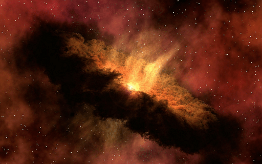
The Gaseous Hypothesis of Kant
- Immanuel Kant, a German philosopher, proposed his own theory regarding the origin of the earth in 1755, which was based on Newton’s law of gravity.
- Kant believed that the original substance was initially distributed and was made up of cold, unmoving, solid particles.
- They clashed with each other because of gravity, which produced heat, which induced angular momentum, and it began to rotate.
- Later, it evolved into a hot nebula that began rotating, causing the speed to progressively increase.
- This rotation resulted in a strong centrifugal force, which produced rings of matter, which cooled to become planets and satellites.
- According to the widely accepted nebular hypothesis, the earth formed from a massive cloud made primarily of hydrogen and helium.
- Contraction, rotation, and lowering temperatures resulted in the formation of small particles. After tens of millions of years of condensation and accretion, these started to clump together, and the earth was created about 4.5 billion years ago.
Criticism of Kant’s Theory
- Kant claimed that the universe included primordial matter, but he did not explain where the primordial matter came from.
- Kant did not explain the source of energy that caused the random motion of the original matter particles, which were first cold and unmoving.
- It is impossible for the primordial matter’s particles to collide and produce rotatory motion. It’s an incorrect mechanism statement.
- Law of conservation of angular momentum: Kant believes that the rotatory speed of the nebula increased as its size grew, which contradicts the law of conservation of angular momentum.
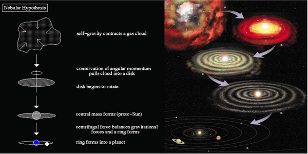
Nebular Hypothesis of Laplace
- Kant’s theory was revised in 1976 by mathematician Laplace.
- According to the nebular hypothesis, the Sun was encircled by a solar nebula made up primarily of hydrogen and helium, as well as dust.
- The development of a disk-shaped cloud is caused by particle impact and friction.
- Planets were formed from material associated with the young sun as a result of the accretion process.
Criticism of Nebular Hypothesis
- The nebula’s origins are not explained by the nebula hypothesis.
- It was unable to explain the sources of nebula heat and motion.
- According to the nebular hypothesis, because the nebula is gaseous, the planet should likewise be gaseous, however, this is not the case.
- The hypothesis fails to explain how the development of solid planets is caused by house gas nebulae.
- The planets and satellites should all rotate in the same direction as the nebula, however, this isn’t the case.
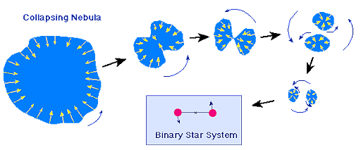
Binary Theory or Planetesimal Hypothesis of Chamberlin
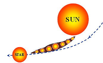
- In 1900, Chamberlain and Moulton gave this theory.
- According to this theory, another wandering star approached the sun.
- As a result, the material’s cigar-shaped extension from the solar surface was separated.
- The sun with its very high-temperature projects hot material called the prominences.
- The particles of this material got coalesced to form the planets. A lot of heat was generated in the process.
- Separated material slowly condensed into a planet as the passing star moved away, and the sun continued to spin.
Jean and Jefferys Tidal Theory/Gravitational Theory
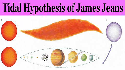
- Jeans and Jeffrey were both scientists from the United Kingdom. To explain the formation of Earth and our solar system, they proposed the “Jeans Jeffreys Tidal Hypothesis.”
- The gravitational force of two stars has resulted in the formation of our solar system.
- Primitive Sun: The primitive sun is the early stage of the sun.
- Intruding Star: In comparison to the primitive sun, it was much larger.
- When intruding stars passed close enough to the primitive sun, hot gas tides rose on it.
- Cigar-shaped hot gaseous particles were separated from the primordial sun when the intruding star was closest to it across the entire traveled distance. Jeans and Jeffrey refer to filament as cigar-shaped.
- Because the filament’s central sectors were bulgy and had more gas material, bigger planets like Jupiter and Saturn were formed.
- On both sides of the filament, smaller planets were produced.
Criticism of Jean and Jeffreys Tidal Theory
- Our solar system’s planets are made up of heavier atomic material, but if the planets’ material is carved from the sun, it should be made up of lighter atomic material like helium and hydrogen.
- The process and mechanism of condensation were not explained.
- In the universe, stars are so far apart that there are few chances of intruding stars.
- Jean Jeffrey did not give much information about the intruding star and its origin.
Russell’s Binary Star Hypothesis
- The theory propounded the existence of binary (two) stars, the bigger one of which ejected mass under the influence of a third one coming close at higher speed, leading to the formation of planets.
Criticisms of Russell’s Binary Star Hypothesis
The intruding star and the remnant of the star from which stuff was ejected are not explained by Russell’s binary Star Hypothesis.
Hoyle’s Supernova Hypothesis

- In 1946, Fred Hoyle proposed this theory.
- The sun used to be twinned with another star, which burst due to nuclear processes that transformed lighter components into heavier ones.
- The companion star’s explosion produced a cloud of incandescent gases, which he refers to as the “Supernova stage.”
- As the nucleus receded far away, the sun’s gravitational power kept this gaseous cloud and the rest of the star together.
- The gaseous cloud at the supernova stage contains iron and other earth elements.
- The earth, as well as other planets and satellites, were formed from these particles.
- They revolved around the sun because they were in the sun’s gravitational field, and gradually cooled to the solid form in which the planets and satellites exist today.
Schmidt’s Interstellar Hypothesis
- According to this theory, the primordial dust began to coalesce into a disk-shaped configuration as it moved at a high pace.
- These disk-shaped nebulae were further subdivided into rings, each holding asteroids that eventually merged into planets.
Criticism of Schmidt’s Interstellar Hypothesis
- Schmidt didn’t go into detail about how these mysterious substances came to be. Schmidt dubbed these black particles “interstellar dust“.
Big Bang Theory
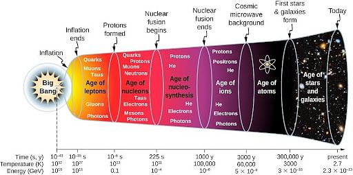
- After Edwin Hubble proposed the constant expansion of the Universe, another Belgian cosmologist came up with the Big Bang Theory in 1931.
- According to the big bang theory, all of the matter that made up the universe resided in a single location with a volume smaller than an atom, an unlimited temperature, and an infinite density.
- The theory suggests that the Universe, at some point in time, was condensed into a single particle and later started expanding infinitely after a huge explosion.
- The expansion later gave birth to nebulae that in turn, coalesced into stars and planets.
- The science community unanimously agrees over the age of the Universe to be around 13.8 billion years.
- Around 3 lakh years after the big bang, the universe turned transparent due to the production of atomic matter.
Conclusion
Origin of Earth is a captivating journey spanning 4.54 billion years, shaped by early theories like Kant’s Gaseous Hypothesis and Laplace’s Nebular Hypothesis. As we explore diverse perspectives, from Chamberlin’s Planetesimal Hypothesis to Hoyle’s Supernova Hypothesis, and embrace modern theories like the Big Bang Theory, we gain profound insights into the dynamic processes that birthed our planet. Despite the criticisms, these theories collectively contribute to our understanding of Earth’s remarkable evolution within the vast cosmic tapestry.
The age of our Earth, estimated at approximately 4.6 billion years, has been gleaned from the examination of meteorites and moon rock samples. Preliminary analysis of the most ancient rock samples found on Earth, focusing on radioactive elements, has revealed their age to be around 3.9 billion years.
The most dependable insights into the Earth’s age have been furnished by the study of radioactive materials. Pioneers in this field, such as Pierre Curie and Rutherford, computed that the Earth’s age falls within the range of two to three billion years. Additionally, the French scientist Caste-de-Buffon made one of the earliest endeavours to unravel the geological history of our planet.
In the contemporary context, Earth’s history is delineated into distinct Eras, which are subsequently organised in chronological order into Epochs. Each Epoch, in turn, is subdivided into periods known as “Shakas” (Periods). This structured division aids in comprehending and tracking the Earth’s geological evolution.

PRE PALEOZOIC ERA
Divided into two archean and precambrian
ARCHEAN PERIOD
This period is marked by a striking absence of fossils within its rock formations, which is why it is often referred to as the Azoic period. The predominant rock types in this era are granite and gneiss, and these formations have been found to contain valuable resources such as gold and iron.
Notably, during this time, the Canadian and Fennoscandian Shields took shape. These geological features are a testament to the geological events and processes that unfolded during the Azoic period.
PRE CAMBRIAN PERIOD
During this period, a noteworthy development was the emergence of invertebrate organisms, which lack a spinal column. Invertebrates with soft, unarmored skin were predominantly present in the warm seas. Although vertebrate life initially made its debut in oceanic environments, terrestrial life was conspicuously absent.
In the Indian subcontinent, this period witnessed the formation of the Aravalli Mountains and the Dharwad series of rocks, adding to the geological history of the region.
PALEOZOIC ERA
CAMBRIAN PERIOD
During this period, a significant event occurred as the seas began to encroach upon the terrestrial land areas for the first time. The Cambrian period is notable for the formation of the Earth’s oldest sedimentary rocks. In India, this era saw the creation of the Vindhyachal mountain range.
Throughout this time, shallow seas on Earth experienced cyclical expansions and contractions. Cambrian rock formations are found in various regions, including Wales in Great Britain, northwest Scotland, western England, Canada, and the United States.
This period is particularly significant because it witnessed the earliest appearance of plants and animals on Earth. In addition, algae originated in the seas during the Cambrian period, marking an essential step in the planet’s biological evolution.
ORDOVICIAN PERIOD
In this period, a notable geological event occurred as the sea expanded, submerging a significant portion of North America. Meanwhile, eastern America experienced mountain-building activities associated with the Taconian orogeny. Despite these dynamic changes, the land area remained devoid of life.
During this time, there was a noteworthy expansion of plant life and sea-dwelling creatures, although the land itself remained uninhabited. These developments further shaped the Earth’s evolving ecosystems.
SILURIAN PERIOD
During this period, the Earth witnessed the far-reaching effects of the Caledonian orogeny, which impacted all continents. As a result of this geological movement, the Appalachian Mountains in North America, as well as their counterparts in Scotland and Scandinavia, were formed.
The Silurian period is often referred to as the “Age of Vertebrates” because it marked the first appearance of vertebrate life on land. Additionally, significant developments occurred in the seas, with the origin of fishes. Coral organisms also underwent noteworthy evolution during this time.
Crucially, this period saw the emergence of plants on land for the first time. These early land plants were devoid of leaves and had their origins in Australia. The Silurian era was characterized by extensive Caledonian mountain-building movements, which played a pivotal role in shaping the Earth’s geological and biological landscape.
DEVONIAN PERIOD
The Caledonian movement left a lasting mark on the Earth, giving rise to towering mountain ranges on every continent. Remnants of this movement are visible in regions such as Scandinavia, South-West Scotland, Northern Ireland, and Eastern America.
In antiquity, the Earth’s climate was highly conducive to marine life, particularly fish. It was during this period that shark fish made their debut, earning this era the moniker “Fish Age.” Concurrently, amphibians and ferns also had their origins. Some of these ancient ferns grew to impressive heights, reaching up to 40 feet, marking a remarkable chapter in the evolution of plant life.
CARBONIFEROUS PERIOD
During this period, the Caledonian movements gave way to the Armenian movements, which had a significant impact on Britain and France. Notably, reptiles made their appearance on land during this time, marking a crucial milestone in the evolution of terrestrial life.
Another remarkable development in this era was the emergence of trees, some of which reached towering heights of up to 100 feet. This period is often referred to as the “Age of Large Trees” or the “Glyptceris period.”
It was also during this time that trees were buried in the geological faults that ultimately formed rocks of the Gondwana sequence. These rocks contain abundant coal deposits, leading to the era being commonly known as the “Carboniferous Kalp” or the “Coal Age.” The significant coal reserves found in these rocks have had a profound impact on Earth’s industrial history.
PERMIAN PERIOD
In this period, the Earth experienced the Variscan orogeny, primarily affecting the continent of Europe. Over time, the climate gradually transitioned to a drier state. The Variscan movement resulted in the creation of rifts, leading to the formation of block mountains, including notable features such as the Black Forest and Vosges.
Additionally, this period witnessed the formation of several other mountain ranges, such as the Spanish Meseta, Altai, Tianshan, and the Appalachian Mountains. These geological developments significantly altered the landscape of the Earth.
During this time, there was a proliferation of diverse species of fauna and flora on the land, contributing to the planet’s evolving ecosystems. Moreover, potash deposits were formed in the Earth’s crust through the evaporation of internal lakes resulting from the fracturing of the Earth’s surface.
MESOZOIC ERA
TRIASSIC PERIOD
This period is often referred to as the “Age of Reptiles” because it marked a significant development with the emergence of large land-dwelling reptiles.
During this era, a noteworthy species called Archaeopteris came into existence. What made Archaeopteris particularly remarkable was its ability to navigate both land and sky, setting it apart as an early example of a creature with dual adaptability.
Furthermore, this period saw the rapid emergence of various life forms. Fast-swimming lobsters made their appearance in the oceans, and mammals began to appear on land. In the aquatic realm, carnivorous fish-like reptiles originated.
On the terrestrial front, this era witnessed the origin of frogs and tortoises, contributing to the diversification of life on Earth.
JURASSIC PERIOD
This period is often referred to as the “Age of Reptiles” because it marked a significant development with the emergence of large land-dwelling reptiles.
During this era, a noteworthy species called Archaeopteris came into existence. What made Archaeopteris particularly remarkable was its ability to navigate both land and sky, setting it apart as an early example of a creature with dual adaptability.
Furthermore, this period saw the rapid emergence of various life forms. Fast-swimming lobsters made their appearance in the oceans, and mammals began to appear on land. In the aquatic realm, carnivorous fish-like reptiles originated.
On the terrestrial front, this era witnessed the origin of frogs and tortoises, contributing to the diversification of life on Earth.
CRETACEOUS PERIOD
During this period, Earth saw some significant changes. Angiosperm plants, which produce flowers and fruits, started to develop. The Rocky and Andean Mountains began to take shape, shaping the landscape.
Large turtles made their appearance during this time, adding to the diversity of life on Earth. We also witnessed the evolution of temperate deciduous forest trees like Magnolia and Poplar.
Geologically, chalky soil was deposited in various regions including northwestern Alaska, Canada, Mexico, the British Dover area, and Australia. In India, the Deccan Traps and black soil were formed due to volcanic eruptions that released lava through fissures in the Earth’s crust. These geological events left a lasting impact on India’s landscape.
CENOZOIC ERA
PALEOCENE PERIOD
The Laramide movement in this period played a crucial role in shaping the Rocky Mountains in North America. It was also a time when mammals started to expand their presence on land. Additionally, this period witnessed the first appearance of both mammals and apes, marking significant milestones in the evolution of life on Earth.
EOCENE PERIOD
During this period, volcanoes erupted through cracks on the Earth’s surface, and land-dwelling creatures, especially crawlers, were at risk of extinction. In Myanmar, ancient monkeys and gibbons made their debut. On the land, the ancestors of elephants, horses, rhinoceroses, and boars began to appear, contributing to the diversity of life on Earth.
OLIGOCENE PERIOD
During this period, the formation of the Alpine Mountains commenced. The Great Himalayan mountain range, which is one of the world’s most prominent features, had its origins in the Oligocene period.
MIOCENE PERIOD
The Alpine Mountain-building activities during this period led to the development of folds across Europe and Asia, primarily expanding in an east-west direction. It was also a time when various significant species came into existence, such as large-sized shark fish measuring up to 60 feet, tailless monkeys known as proconsul, water birds like swans and ducks, and even penguins.
The evolution of elephants also marked a key development during this period. Importantly, it’s the era when the middle or lesser Himalayan mountain range began to take shape, further shaping the Earth’s landscape.
PLIOCENE PERIOD
Continuous sedimentation in the seas during this period gave rise to the formation of extensive plains in regions such as Europe, Mesopotamia, northern India, Sindh, and North America. This sedimentation process significantly shaped the geography of these areas.
It was also a time when human ancestors continued to evolve, and modern mammals emerged, contributing to the diversity of life on Earth. The Shivalik mountain range originated during this period, adding to the Earth’s geological features.
The deposition of sediments in the Tethys geosyncline, a water-filled basin situated between the Himalayan ranges and the peninsular part of India, played a pivotal role in the formation of the northern plains of India, further influencing the topography of the subcontinent.
NEOZOIC ERA
PLEISTOCENE PERIOD
During this time period, there was a notable drop in temperatures, leading to the occurrence of four ice ages in Europe: Gunz, Mindel, Riss, and Wurm. These ice ages were separated by relatively warmer interglacial periods. The interglacial period between Mindel and Riss was the longest.
In North America, several ice ages were observed, including the Nebraskan, Kansas, Illinois, Iowa, and Wisconsin ice ages. These ice ages were punctuated by interglacial periods, with the Aftonian between Nebraskan and Kansan, Yarmouth between Kansan and Illinoian, and Sangamon between Illinoian and Wisconsin.
Towards the end of this era, the ice sheets continued to melt, and the western Scandinavian region’s elevation increased. It’s believed that flying birds made their appearance on Earth during the Pleistocene period. Notably, this period witnessed the evolution of humans and other mammals into the forms we recognize today.
HOLOCENE PERIOD
The rise in temperature led to the melting of the Earth’s surface ice, which brought us to the present state of the world, a condition that persists today. It was during this period that sea creatures evolved to their current forms. Additionally, humans began practicing agriculture and animal husbandry on land, marking the beginnings of these crucial aspects of human civilization.
The interior structure of the Earth is a captivating realm that has intrigued scientists and explorers for centuries. Beneath the familiar surface lies a complex and dynamic composition of layers, each with its own distinct properties and behaviors. From the solid, rigid crust that forms the planet’s outer shell to the molten depths of the mantle and the dense, metallic core at its center, the Earth’s interior is a testament to the forces of geological processes that have shaped our planet over billions of years. Through a combination of seismic studies, geological sampling, and theoretical modeling, scientists continue to unravel the mysteries of the Earth’s interior, shedding light on its formation, evolution, and ongoing dynamics. Understanding the intricacies of the interior structure not only deepens our knowledge of the Earth itself but also provides invaluable insights into phenomena such as earthquakes, volcanic activity, and the movement of continents, ultimately shaping our understanding of the dynamic processes that govern our planet.
STRUCTURE OF EARTH
The Earth’s surface is constantly transformed by two types of forces: endogenic forces, which are internal, and exogenic forces, which are external. These changes brought about by these forces are collectively referred to as “geomorphic processes.”
Diastrophism is the specific process responsible for reshaping the Earth’s surface through the movement and displacement of rocks. It encompasses two main categories: orogenic processes, which lead to the formation of mountains, and epeirogenic processes, which are involved in the shaping of continents.
The Earth’s interior can be divided into several layers: the crust, upper mantle, lower mantle, outer core, and inner core. As we move from the Earth’s crust towards its core, the temperature steadily increases. Typically, the temperature rises by about 1 degree Celsius for every 32 metres toward the Earth’s interior.
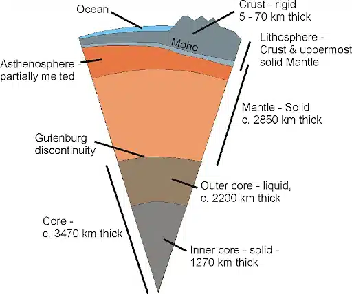
CRUST
- The Earth’s crust is the outermost solid layer of the planet. It’s divided into two main parts: the upper crust, often referred to as the continental crust, which is primarily composed of silica and aluminum (known as “sial”), and the lower crust, known as the oceanic crust, which is made up of silica and magnesium (termed “sima”).
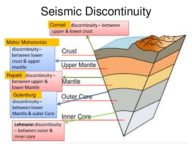
- The boundary that separates these two layers is called the “Conorod boundary.”
- The thickness of the Earth’s crust is not uniform and varies between continental and oceanic regions. Continental crust is generally thicker than oceanic crust.
- On average, the continental crust is about 32 kilometres thick, whereas the oceanic crust is much thinner, measuring approximately 5 kilometres in thickness. In areas with major mountain systems, such as the Himalayas, the continental crust can be exceptionally thick, reaching up to about 70 kilometres.
- The density of the Earth’s crust is less than 2.7 grams per cubic centimetre (g/cm³).
MANTLE
- Beyond the Earth’s crust lies a layer known as the mantle. The mantle is primarily composed of magnesium, silica, and iron and extends to a depth of approximately 2900 kilometres below the Earth’s surface.
- The mantle itself is further divided into two main sections: the upper mantle and the lower mantle.
- The upper part of the mantle, referred to as the asthenosphere, extends to a depth of about 400 kilometres. The term “astheno” signifies weakness, and the asthenosphere is characterised by its partial melt and flow, which plays a crucial role as the primary source of magma that reaches the Earth’s surface during volcanic eruptions.
- The boundary separating the lower crust from the upper mantle is known as the “Mohorovičić discontinuity” or simply the “Moho.”
- The mantle has a density of approximately 3.9 grams per cubic centimetre (g/cm³).
- The combined layer consisting of the Earth’s crust and the uppermost part of the mantle is referred to as the lithosphere. Its thickness can vary, ranging from 10 to 200 kilometres.
CORE
- Core- a region predominantly made up of heavy elements, particularly iron and nickel. This core is often referred to as the NiFe or Barysphere.
- It occupies the central portion of the Earth and has a remarkably high density, measuring about 13 grams per cubic centimeter (g/cm³).
- The core itself is divided into two main layers: the outer core, which is in a liquid state, and the inner core, which remains solid. The temperatures in this region are extremely high, ranging from approximately 5500°C to 6000°C.
- The Gutenberg margin delineates the separation between the lower mantle and the outer core.
- The Lehmann boundary marks the division between the outer core and the inner core.
- The core spans a considerable depth, extending from 2900 kilometres below the Earth’s surface to the very centre of the planet at 6378 kilometres.
EARTH’S CHEMICAL COMPOSITION
The Earth’s mass is estimated to be around 5.97 x 10^24 kilograms, which is equivalent to 5,970 yottagrams (Yg). This immense mass is composed of various elements, with the most abundant being:
- Iron (Fe): Approximately 32.1% of the Earth’s composition.
- Oxygen (O): Approximately 30.1%.
- Silicon (Si): About 15.1%.
- Magnesium (Mg): About 13.9%.
- Sulphur (S): Approximately 2.9%.
- Nickel (Ni): About 1.8%.
- Calcium (Ca): Approximately 1.5%.
- Aluminium (Al): About 1.4%.
Additionally, there are trace amounts of other elements, making up the remaining 1.2% of the Earth’s composition. This diverse combination of elements contributes to the Earth’s unique characteristics and plays a crucial role in shaping its geology, chemistry, and overall properties.
Earth movements encompass a dynamic array of geological processes that continually shape and reshape the Earth’s surface. These movements are broadly categorized into endogenetic and exogenetic processes, each playing distinct yet interconnected roles in sculpting the planet’s landscape. Endogenetic processes originate from within the Earth, driven by forces such as tectonic activity and volcanic eruptions, while exogenetic processes result from external agents like weathering and erosion. Together, these forces contribute to the ever-evolving topography of our planet, exerting profound impacts on its geological features and environmental systems. Understanding the mechanisms and interactions of these movements is essential for comprehending the complex evolution of Earth’s surface over geological time scales.
- The Earth’s surface is in a constant state of change due to forces originating from both within the Earth (endogenic forces) and external influences (exogenic forces).
- These forces bring about various physical and chemical alterations to the Earth’s surface, collectively known as geomorphic processes. These processes can be categorised based on their speed of occurrence.
- Some of these changes happen at an almost imperceptibly slow pace, such as weathering and folding. Others occur more gradually, like erosion, which shapes the landscape over time. In contrast, some changes are sudden and impactful, exemplified by phenomena like earthquakes and volcanic eruptions.
- The term “geomorphic” relates to the form and natural features of the Earth’s surface.
- Geomorphic agents, like running water, glaciers, wind, waves, and currents, are mobile mediums that work to remove, transport, and deposit Earth materials. These agents play a crucial role in shaping the landscape.
- Geomorphic processes encompass the physical and chemical transformations that occur on the Earth’s surface. These processes result from the interplay of endogenic and exogenic forces and include phenomena such as folding, faulting, weathering, and erosion.
- Geomorphic movements refer to significant-scale changes on the Earth’s surface caused by geomorphic processes. These movements alter the landscape through physical and chemical means and are a fundamental aspect of the dynamic nature of the Earth’s surface.
ENDOGENETIC GEOMORPHIC MOVEMENTS
- Endogenic geomorphic movements refer to the significant shifts and alterations occurring on the Earth’s crust or surface due to forces originating from deep within the Earth (endo: internal; genic: origin; geo: earth; morphic: form). These movements encompass the transformative actions caused by internal forces shaping the Earth’s structure and landscape.
- Endogenic geomorphic processes are the set of processes driven by forces originating from the depths of the Earth.
- These processes, such as folding and faulting, are responsible for shaping the Earth’s surface, forming mountain ranges, and causing changes through internal forces acting on the crust.
Endogenic movements are categorised into two main types: diastrophic movements and sudden movements.
Diastrophism characterises the gradual deformation and alteration of the Earth’s crust. These movements may occur over extended periods, spanning thousands of years.
Sudden movements, such as earthquakes and volcanic eruptions, occur abruptly and over relatively brief time spans.
Within diastrophic movements, two key categories exist:
- Epeirogenic movements encompass changes related to the formation and development of continents. These movements involve subsidence (sinking) and upliftment of land and can occur over prolonged periods.
- Orogenic movements are associated with mountain-building activities, which include folding and faulting processes that create mountain ranges.

EXOGENETIC GEOMORPHIC MOVEMENTS
- Geomorphic processes that shape the Earth’s surface, influenced by forces from above the surface like wind and water, are referred to as exogenic geomorphic processes.
- These processes lead to exogenic movements such as weathering and erosion, resulting from external forces acting upon the Earth’s surface.
- Most exogenic geomorphic processes create gradual and minor effects. However, over time, these continuous actions have a significant impact on rocks and land due to long-term wear and tear.
DENUDATION
- All the exogenic processes, including weathering and erosion, fall under the general term ‘denudation.’ This term refers to the action of stripping off or uncovering layers from the Earth’s surface.
- Denudation relies on both physical and chemical characteristics of rocks, encompassing factors like folds, faults, bed orientation, joint presence, mineral hardness, and chemical susceptibility to corrosion.
- These elements collectively impact the breakdown and removal of surface materials.
WEATHERING
- Weathering is the breakdown of rocks, soil, and minerals due to physical factors like heat and pressure, as well as chemical elements such as leaching, oxidation, reduction, and hydration.
- It’s considered an in-situ or on-site process because it doesn’t involve significant movement of materials. Weathering causes materials to break down right where they are. Once materials are weathered, erosion carries them away.
- There are three primary categories of weathering processes: chemical, physical (mechanical), and biological. These types of weathering often work together, collectively influencing the breakdown of materials.
Earthquakes and volcanoes are two examples of sudden movements that generate significant deformation in a short period of time. Any sudden shaking of the ground generated by seismic waves passing through Earth’s rocks is referred to as an earthquake whereas a volcano is a crack in the earth’s crust that allows lava, volcanic ash, and gases to escape. Liquid magma with dissolved gases rises through cracks in the Earth’s crust beneath a volcano.
Earthquake
- An earthquake is the shaking of the surface of the Earth resulting from a sudden release of energy in the Earth’s lithosphere that creates seismic waves.
- Earthquakes can range in size from those that are so weak that they cannot be felt to those violent enough to toss people around and destroy whole cities.
- The seismicity, or seismic activity, of an area refers to the frequency, type, and size of earthquakes experienced over a period of time. The word tremor is also used for non-earthquake seismic rumbling.
- The cause of earthquakes is often due to the movement of tectonic plates beneath the Earth’s surface.
- When these plates move past each other, they sometimes get stuck at their edges due to friction.
- When the stress on the edge overcomes the friction, there is an earthquake that releases energy in the form of seismic waves, which causes the ground to shake.
- The location below the Earth’s surface where the earthquake starts is called the hypocenter, and the location directly above it on the surface is called the epicenter.
- Earthquakes can occur anywhere, but their most common sites are along tectonic plate boundaries.

Types of Earthquakes
Natural earthquakes are those which are caused by natural processes i.e., due to endogenic processes. These are further subdivided into the following sub-categories:
On the Basis of Causative Factors
1) Tectonic Earthquakes
- They are caused due to dislocation of rock blocks during faulting activities.
- They are the most common ones.
- A tectonic earthquake occurs when two tectonic plates collide at a point called the boundary.
- A convergent plate boundary is formed when two plates push into each other.
- The oceanic Nazca Plate, for example, pushes into and is subducted into the South American Plate off the coast of South America along the Peru-Chile trench.
- The Andes mountains were formed as a result of this action, which raised the South American Plate.
- The Nazca Plate is broken into smaller pieces that are stuck in place for lengthy periods of time before shifting suddenly and causing earthquakes.
- The Mid-Atlantic Ridge, which stretches from the Arctic Ocean to beyond the southern tip of Africa, is an example of a divergent boundary, which happens when two plates shift away from each other, forming a new crust.
- It has produced thousands of kilometers of plate movement over millions of years.
- When plates slide horizontally past one another, they generate a transform boundary that neither destroys nor produces crust.
- Plate movement results in zigzagging plate edges and shallow earthquakes.
- These are also generated due to the sliding of rocks along a fault plane. Example: 2001 earthquake in Gujarat.
2) Volcanic Earthquakes
- Volcano earthquakes are caused by stress changes in the solid rock caused by the injection or withdrawal of magma (molten rock).
- They are caused due to volcanic eruptions of explosive and fissure types.
- The intensity and magnitude of the earthquake depend on the intensity and magnitude of volcanic eruptions.
- We can’t predict when the volcano will erupt, but it might happen at any time. Example: severe earthquakes caused by Karakatao volcano 1883.
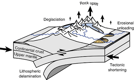
3) Isostatic Earthquakes
- Isostatic or isostasy-related earthquakes are those associated with the buoyant behavior of the Earth’s crust as it undergoes vertical movements due to changes in surface loads.
- The term “isostasy” refers to the equilibrium that exists between the Earth’s lithosphere (the crust and uppermost mantle) and the more fluid asthenosphere beneath it.
- The lithosphere essentially “floats” on the asthenosphere in a manner similar to how an iceberg floats on water.
- They are triggered due to sudden disturbances in isostatic balance at a regional scale.
- If a significant weight, such as a massive ice sheet, is added to or removed from the crust, the crust will respond by sinking or rebounding, respectively.
- A classic example of isostatic adjustment is seen in areas that were once covered by large ice sheets during the last Ice Age.
- As these ice sheets melted, the previously compressed crust began to rise or “rebound” back to its original position.
- This process, which can take thousands of years, can cause earthquakes, although they are typically of lower magnitude.
- This rebound is often referred to as post-glacial or glacio-isostatic rebound.
- Mountains, after being built up due to tectonic forces, can undergo erosion over millions of years. As they erode, the crust can adjust isostatically, leading to earthquakes.
4) Plutonic Earthquakes
- They are deep-focus earthquakes whose centers lie at depths from 240 km to 600 km.
- They occur almost exclusively at convergent boundaries in association with subducted oceanic lithosphere.
- Herbert Hall Turner initially brought preliminary evidence for the presence of deep-focus earthquakes to the attention of the scientific community in 1922.
- Kiyoo Wadati demonstrated the existence of earthquakes deep into the lithosphere in 1928, debunking the myth that earthquakes only occur at shallow focal depths.
- Deep-focus earthquakes produce very few surface waves. Because of their focal depth, earthquakes are less likely to create a seismic wave motion with concentrated energy at the surface.
- Deep-focus earthquake seismic waves only pass through the heterogeneous upper mantle and highly changeable crust once on their way from the focus to the recording station.
- As a result, compared to seismic waves from shallow earthquakes, body waves experience less attenuation and reverberation, resulting in strong body wave peaks.
5) Artificial or Man Induced Earthquakes
- They are caused by anthropogenic activities such as underground explosions, mining, large reservoir-induced pressure, etc.
- Example: The enormous load exerted by dam reservoirs resulted in the strongest ever induced earthquake.
- The most notable fluid-induced earthquake in India happened in 1967 near Koyna, Maharashtra, and was ascribed to seismic activity caused by the Koyna dam’s impoundment.
- Earthquakes in Oklahoma’s tectonically quiet region have also been connected to oil and gas drilling activity.
- Such areas of man-made earthquake activity are thought to exceed the degree of seismic activity in hotspots like southern California.
On the Basis of Focus of the Earthquake
1) Shallow Focus Earthquakes
- It has its seismic foci located at depths from the ground surface to 50 km.
- The majority of earthquakes have a shallow focal point. As a result, they’re also known as ‘crustal earthquakes.’
- Smaller earthquakes make up the majority of shallow-focus earthquakes (usual range of 1 to 5). However, a few are of greater magnitude and can create widespread devastation.
- They happen frequently and seemingly at random. However, because the majority of them are of minor magnitude or occur along submarine ridges, they are rarely felt.
- Shallow focus earthquakes are particularly common at divergent boundaries, such as mid-ocean ridges, and transform boundaries, like the San Andreas Fault in California.
2) Intermediate Focus Earthquakes
- Intermediate focus earthquakes are seismic events that originate at depths ranging from 70 km to 300 km below the Earth’s surface.
- These earthquakes predominantly occur in subduction zones where one tectonic plate is being forced under another. As the subducting plate descends into the mantle, it can cause earthquakes at varying depths, including the intermediate range.
- While shallow focus earthquakes are the most common, intermediate focus events also occur frequently, especially in regions with active subduction zones.
- Examples include the Pacific “Ring of Fire”, which encircles the Pacific Ocean and features many subduction zones.
- The intensity of shaking at the Earth’s surface from an intermediate focus earthquake can be less than that of a similarly sized shallow focus earthquake.
- This is because the seismic waves have a longer distance to travel before reaching the surface, which can cause them to dissipate some of their energy.
- Examples: The 2011 earthquake off the Pacific coast of Tōhoku, Japan, which led to the devastating tsunami and Fukushima Daiichi nuclear disaster, was an intermediate focus earthquake. Another example is the 1976 Tangshan earthquake in China.
3) Deep Focus Earthquakes
- Deep focus earthquakes are seismic events that originate at depths ranging from 300 km to about 700 km beneath the Earth’s surface. It is also known as Wadati–Benioff Zone.
- They stand out because, at such profound depths, the Earth’s materials are expected to deform ductilely rather than fracture and slip, which is how earthquakes typically occur.
- Like intermediate focus earthquakes, deep focus earthquakes predominantly occur in subduction zones, where one tectonic plate is diving beneath another into the mantle.
- The occurrence of earthquakes at these depths is somewhat enigmatic because temperatures and pressures are so high that rocks are expected to deform plastically rather than breaking in a brittle fashion.
- Several mechanisms, such as phase transitions (changes in the crystal structure of minerals), have been proposed to explain these events.
- Deep focus earthquakes are particularly common in a few subduction zones around the Pacific “Ring of Fire.”
- Regions such as beneath the Fiji-Tonga area in the South Pacific and beneath the Sea of Okhotsk off the Russian Far East are known for these types of earthquakes.
- Like intermediate focus earthquakes, the intensity of shaking from a deep focus earthquake at the Earth’s surface can be less than that of a similarly sized shallow focus earthquake. They can, however, still be of high magnitude and potentially damaging.
- Examples: One of the most significant deep focus earthquakes in recorded history was the 2013 Sea of Okhotsk earthquake, with a depth of approximately 609 km and a magnitude of 8.3.
- Because deep focus earthquakes occur at depths inaccessible for direct study, their investigation offers valuable insights into the Earth’s deep interior, the properties of materials under extreme conditions, and the complex interactions in subduction zones.
Causes and Effects of Earthquake
- Earthquakes occur when excess stored tension in rocks in the earth’s interior owing to bending, faulting, or other physical processes is released as kinetic energy through weak zones on the surface.
- Coastal areas may experience uplift or subsidence as a result of these shifts.
- Plates’ tectonics theory has been accepted as the most possible explanation of the causes of earthquakes.
- As per this theory, the crust of the earth is composed of solid moving plates.
- These plates are constantly moving in relation to each other due to thermal convective currents originating deep within the earth.
- Thus, all the seismic events take place along the boundaries of these moving plates
- Alterations in contours, river courses, coastline changes, glacier surges, landslides, soil slips, mass wasting, and other effects may occur as a result of earthquakes.
Examples of Earthquake due to Uplift and Subsidence
- A one-meter uplift in coastal areas was produced by an earthquake in Chile in 1822.
- An earthquake in New Zealand in 1885 resulted in a 3-meter rise.
- An earthquake in Japan in 1891 caused up to 6 meters of subsidence.
Volcanoes
- The movement of molten rock (magma) onto or towards the earth’s surface through narrow volcanic vents or fissures is known as volcanism.
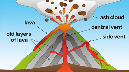
- A volcano is formed when molten magma from the earth’s interior erupts through vents and cracks in the crust, accompanied by steam, gases such as hydrogen sulphide, sulphur dioxide, hydrogen chloride, carbon dioxide, etc. and pyroclastic material (cloud of ash, lava fragments carried through the air, and vapour).
- A volcano can adopt many different shapes depending on the chemical composition and viscosity of the lava.
Types of Volcanoes
On the Basis of their Eruption
- Active: An active volcano is one that has recently erupted or is on the verge of erupting again.
- Dormant: A dormant volcano is one that hasn’t erupted in a long time but is still capable of doing so in the future.
- Extinct: An extinct volcano is one that last erupted thousands of years ago and no longer has the potential to erupt.
On the Basis of their Shape
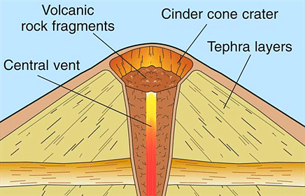
Cinder Cones
- Cinder cones are round or oval cones made up of tiny lava pieces that have been blown up from a single vent.
- Cinder cones are formed by the accumulation of largely small fragments of scoria and pyroclastics around the vent.
- The majority of cinder cones only erupt once.
- Cinder cones can arise as side vents on bigger volcanoes or as isolated cinder cones.
- Examples: Parícutin in Mexico and Sunset Crater in the USA.
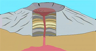
Composite Volcano
- Composite volcanoes are steep-sided volcanoes made up of multiple layers of volcanic rocks, most of which are made up of high-viscosity lava, ash, and rock debris.
- These volcanoes are towering conical mountains made up of lava flows and other ejecta layered in alternate layers, hence the name strata.
- Cinder, ash, and lava make up composite volcanoes.
- Cinders and ash build up on top of one another, lava flows over the ash, cools and hardens, and the cycle continues.
- Examples: Mount St. Helens in the USA, Mount Fuji in Japan, and Mount Pinatubo in the Philippines.
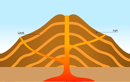
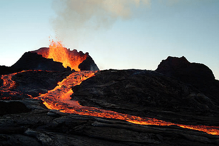
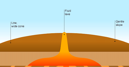
Shield Volcano
- Shield volcanoes have long, gradual slopes formed by basaltic lava flows and are fashioned like a bowl or shield in the middle.
- These are generated by the eruption of low-viscosity lava that can travel a long way from the vent.
- They don’t usually blow out in a big way.
- Shield volcanoes are more prevalent in marine than continental settings because low-viscosity magma is often low in silica.
- Shield cones are found throughout the Hawaiian volcanic system, and they are also frequent in Iceland.
- Examples: Mauna Loa and Kilauea in Hawaii.
Lava Domes
- Lava domes arise when erupting lava becomes too thick to flow and stacks up near the volcanic vent, forming a steep-sided mound.
- Slow outbursts of exceedingly viscous lava form them.
- They can sometimes be found within the crater of an earlier volcanic eruption.
- They can erupt violently and explosively, just like a composite volcano, although the lava rarely flows far from the erupting vent.
- Example: Mount St. Helens has a lava dome in its crater.
Volcanic Landscape
- Volcanic landforms are formed by the solidification of lava either inside or outside the earth’s surface.
- When lava is unable to reach the earth’s surface, it penetrates fissures, where it forms various types of intrusive landforms depending on the shape of the fissure and its location relative to the earth’s surface.
- Major intrusive forms include Batholiths, Laccoliths, Lopolith, Phacolith, Sills and Dykes.
Conclusion
Sudden movements such as earthquakes and volcanoes create widespread devastation on the planet’s surface. However, it can be concluded that these earthquakes and volcanoes are important to maintaining the Earth’s crust’s unique structure.
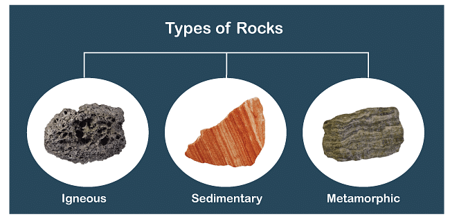
A rock is a solid combination of minerals. The earth’s crust is made up of rocks that are different from one another in texture, structure, colour, permeability, mode of occurrence, and degree of resistance to denudation. Feldspar and quartz are the most common minerals found in rock. There are three main types of rocks: igneous, sedimentary, and metamorphic rocks.
What exactly are Rocks?
- Two or more minerals are combined together through geological processes to form rocks.
- It is categorized by the minerals & chemical composition and the way in which it is formed.
- Rocks can be hard or soft, and they come in a variety of colours.
- Rocks form the basis for soil, to some extent determine the type of natural vegetation and land use.
- Rocks occupy most of the terrain and there is a close relationship between rock and terrain.
- The most prevalent minerals found in all types of rocks are feldspar and quartz.
- The science dealing with the study of rocks is called Petrology.
Types of Rocks
- There are many distinct types of rocks, which are classified into three categories based on their way of development. They are:
- Igneous Rocks — solidified from magma and lava
- Sedimentary Rocks — formed due to deposition of rock fragments by exogenous processes
- Metamorphic Rocks — formed from existing rocks undergoing recrystallization
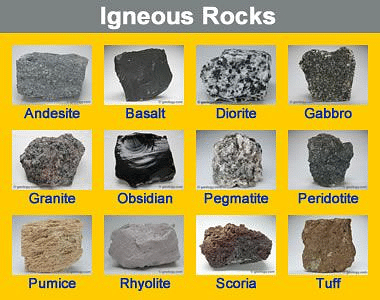
Igneous Rocks
- Igneous rocks are referred to as primary rocks since they are generated from magma and lava from the earth’s interior.
- When magma cools and solidifies igneous rocks (Ignis in Latin means “fire”) form.
- They can form above ground when magma erupts as lava from a volcano.
- They can also form deep below the Earth’s crust and then be exposed at the surface by the erosion of the underlying rocks. Igneous rocks include crystals with angular forms.
- They have not been eroded or squashed like sedimentary or metamorphic rocks.
- Their mineral content and texture — the size and form of their mineral grains — distinguish them.
- The pace of cooling determines texture: magma that cools slowly deep within the Earth makes rock with massive crystals, whereas lava that cools quickly on the surface forms fine-grained rock.
- The majority of igneous rocks are exceptionally hard and resistant to erosion.
- They are quarried for road building and polished as monuments and gravestones.
- Because igneous rocks are formed from super-heated magmatic elements, they do not contain fossils.
- Igneous rocks include granite, gabbro, pegmatite, basalt, volcanic breccia, and tuff, to name a few.
Igneous Rocks
Classification of Igneous rocks
Types of Igneous Rocks:
Extrusive Rocks (Volcanic Rocks)
- When magma escapes and cools above (or very near) the Earth’s surface, extrusive or volcanic igneous rock is formed.
- These are the rocks that emerge when volcanoes erupt and crevices ooze.
- When exposed to the relatively cool temperature of the atmosphere, magma, also known as lava molten rock erupts on the surface, cools and solidifies practically instantaneously.
- Because mineral crystals don’t have much time to form because to the rapid cooling, these rocks have a highly fine-grained or even glassy structure.
- Hot gas bubbles are frequently trapped in quenched lava, resulting in a bubbly, vesicular texture.
- Extrusive igneous rocks include pumice and basalt.
Intrusive Rocks (Plutonic Rocks)
- When magma is imprisoned deep within the Earth, intrusive, or plutonic, igneous rock occurs. Massive globs of molten rock rise to the surface.
- Some of the magma may fuel volcanoes on Earth’s surface, but the majority remains trapped below, where it slowly cools over decades or millions of years until it hardens.
- Because of the slow cooling, the individual mineral grains have a very long time to grow, allowing them to grow to a reasonably enormous size.
- Intrusive rocks are often coarse-grained and highly hard in nature.
- Intrusive igneous rocks include gabbro and granite.
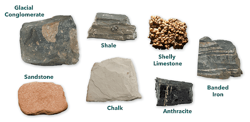
Sedimentary Rocks
- Sedimentary rocks develop from previously existing rocks or fragments of once-living organisms.
- They occur as a result of deposits accumulating on the Earth’s surface. Layering or bedding in sedimentary rocks is common.
- Some form when rock and mineral particles settle out of water or air. Others occur when minerals precipitate out of water directly.
- Minerals and texture distinguish sedimentary rocks.
- Many of the scenic views of the desert southwest feature mesas and arches formed by layered sedimentary rock.
- Water is forced out by the weight of the overlying pile as the sediments build up, and minerals precipitate around the sediment particles, cementing them into rock. This is known as lithification.
- They have a layered or stratified structure as a result of successive depositions and are so-known as Stratified Rocks.
- Classification of sedimentary rocks is done according to their age and different kinds of rocks formed during the same period are grouped together.
- Most of the solid surface of our planet (roughly 70%) is represented by sedimentary rocks.
- Sandstone, Limestone, and Shale are some examples of sedimentary rocks.
Sedimentary Rocks
Types of Sedimentary Rocks
- Mechanically Formed
- Organically Formed
- Chemically Formed
Mechanically Formed Sedimentary Rocks
- Mechanical agents such as moving water, wind, ocean currents, ice, and so on shape them.
- Arenaceous sedimentary rocks are hard and permeable, with more sand and larger particles. For example, sandstone.
- More clay is found in argillaceous rocks, which are fine-grained, softer, and mainly impermeable (mostly non-porous or have very tiny pores).
- Claystone and shales, for example, are mostly argillaceous.
Organically Formed Sedimentary Rocks
- The formation of these rocks is due to the buildup of living creatures such as corals and shellfish.
- There is a lot of organic stuff in these rocks.
- The most well-known calcareous rocks, such as Chalk, are created in this manner.
- Carbonaceous rocks, on the other hand, are created organically, but from vegetative matter.
- Geyserite, chalk, limestone, coal, etc. are some examples of organically formed sedimentary rocks.
Chemically Formed Sedimentary Rocks
- When standing water evaporates, leaving dissolved minerals behind, many of these forms.
- Mineral components in the solution become supersaturated and inorganically precipitate, forming sedimentary rocks.
- Chemically produced sedimentary rocks include chert, limestone, halite, potash, and others.
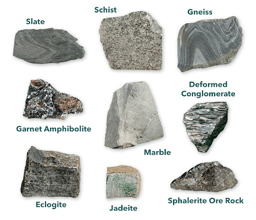
Metamorphic Rocks
- The term “metamorphic” refers to a change in form.
- When rocks are subjected to high heat, high pressure, hot mineral-rich fluids, or, more typically, some combination of these variables, metamorphic rocks develop.
- Such conditions can be encountered deep within the Earth or where tectonic plates collide.
- The minerals and texture of these rocks help to identify them.
- New minerals grow during metamorphism, having different sizes, shapes, and orientations than the initial minerals.
- The chemical composition of the original rock may also alter as fluids moving through the rocks carry away some elements and add others.
- Metamorphosis happens when tectonic processes move rocks to lower levels or when molten magma rising through the crust comes into touch with crustal rocks.
- Metamorphism does not melt rocks but rather converts them into denser, more compact rocks.
- New minerals are formed either by mineral component rearrangement or through interactions with fluids that enter the rocks.
- Even previously metamorphosed rocks can undergo changes due to pressure or temperature.
- Squished, smeared out, and folded metamorphic rocks are common.
- Some rocks’ grains or minerals are arranged in layers or lines during metamorphism. Foliation or lineation is the term for this type of layout.
- Minerals or materials from several groups are sometimes placed in alternating thin and thick layers. Banding is a term for construction like this.
- Metamorphic rocks include gneissic, slate, schist, marble, quartzite, and others.
Metamorphic Rocks
Types of Metamorphic Rocks
- Thermal Metamorphism
- Dynamic Metamorphism
Thermal Metamorphism
- Thermal Metamorphism is the process of changing from one state to another.
- Thermal metamorphism is the change in form or re-crystallization of minerals in sedimentary and igneous rocks caused by high temperatures.
- The peak of Mount Everest, which is made up of metamorphosed limestone, was formed by a magmatic intrusion that caused thermal metamorphism.
- Sandstone becomes quartzite and limestone becomes marble as a result of thermal metamorphism.
Dynamic Metamorphism
- Dynamic Metamorphism is a type of metamorphism that occurs over time.
- The formation of metamorphic rocks under high pressure is known as dynamic metamorphism
- High pressure is sometimes accompanied by high temperatures and chemically charged liquids.
- Metamorphism is a powerful process that occurs when directed pressure and heat combine to induce more or less complete recrystallization of rocks and the formation of new structures.
- Dynamo thermal metamorphism is the term for this process.
Conclusion
These rocks, beyond their geological significance, also provide insights into India’s rich mineral resources, landform development, and geological hazards. Each rock, whether formed from magma, accumulated sediments, or transformational pressures, tells a unique story of our planet’s ever-changing nature.
Weathering is the process of breaking down or dissolving rocks and minerals on the surface of the Earth. Water, ice, acids, salts, plants, animals, and changes in the temperature of the environment are all agents of weathering. Weathering and erosion constantly change the rocky features of Earth. There is a huge significance of weathering, ranging from soil formation to the creation of coastal landforms such as sea caves, sea arches, etc.
What is Weathering?
- Weathering refers to the breakdown and alteration of rocks and minerals at or near the Earth’s surface as a result of atmospheric, chemical, and physical agents.
- Weathering processes are responsible for producing soil from parent rock and altering the rock’s characteristics, preparing it for transportation through erosional processes.
- Weathering is the first stage in the denudation process, which includes weathering, erosion, transportation, and deposition.
- There are three main types of weathering:
- Physical (Mechanical) Weathering
- Chemical Weathering
- Biological Weathering

Elements influencing Weathering Process
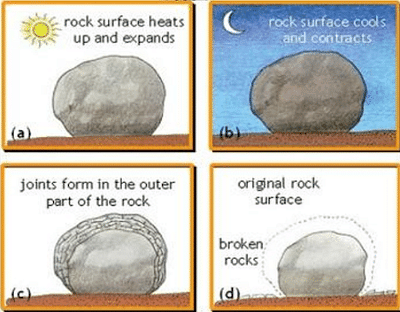
Mechanical Weathering
- It is also called physical weathering. It causes rocks to crumble.
- This involves the physical breakdown of rocks into smaller pieces without a change in their chemical composition.
- Forces such as freezing and thawing, temperature fluctuations, plant roots, and abrasion can cause rocks to crack, flake, or disintegrate.
- The change in temperature can also contribute to mechanical weathering in a process called thermal stress.
- Change in temperature causes the rock to expand with heat and contract with cold.
- As this happens, again and again, the structure of the rock weakens and after some time, it breaks.
Chemical Weathering
- Chemical Weathering changes the molecular structure of rocks and soil.
- Agents of chemical weathering include water, oxygen, carbon dioxide, and organic acids.
- Common processes include hydrolysis, oxidation, carbonation, and solution.
- Sometimes, it dissolves large portions of limestone or other rock on the surface of the Earth to form a landscape called karst.
- One of the world’s best examples of karst is the Stone Forest, near Kunming, China.
Biological Weathering
- The weakening and subsequent disintegration of rock by plants, animals, and microbes is known as biological weathering.
- Plant roots that are growing can put stress or pressure on the rock.
- Despite the fact that the process is physical, the pressure is applied by a biological process (i.e., growing roots).
- Chemical weathering can also be caused by biological processes, such as the production of organic acids by plant roots or microorganisms, which aid in the dissolution of minerals.
Significance of Weathering
- Weathering is the first stage of the formation of soil.
- It produces many other natural resources, for example, clay which is used for making bricks.
- Another significance of weathering is it weakens the rocks, making them easier for people to exploit and break, for example, by mining and quarrying.
- Biodiversity and biomes are the result of vegetation, and forests rely upon the depth of weathering wraps.
- Root penetration cannot happen if the rocks are not weathered.
- It aids erosion, mass wasting, reduction of relief, and modifications in landforms.
- Weathering of rocks helps in the augmentation and concentrations of some ores of manganese, aluminum, iron, copper, etc. which have a great demand in the economy of the country.
- When some rock pieces and particles are broken, they eventually turn into sediments, which form different types of sedimentary rocks such as sandstones and limestones. Typically, the broken rock pieces are deposited by rivers and compacted by great pressure, resulting in the formation of sedimentary rock.
- Some weathered rocks, such as granite tors, are very interesting. As a result, they serve as a tourist attraction. The Bismarck rock in Mwanza, Tanzania, is one example.
- Some of these rocks appear to be so one-of-a-kind that locals are baffled as to how they came to be. They’ve converted them into local shrines where people can make offerings.
Factors Affecting Weathering Processes
Weathering types and rates vary at the regional and local spatial scales. Aside from climate, the type of rock (lithology) and the nature and extent of fractures or other flaws in it have a significant impact on the effectiveness of the various rock weathering processes.
Climate
- Different weathering processes are associated with different climatic conditions
- Chemical weathering, for example, is especially effective and rapid in humid climates.
- In arid climates, chemical weathering is much more limited.
- Salt weathering processes are very effective in marine coastal locations due to the abundance of salts, high humidity, and contact with seawater.
Rock Type
- The character of the bedrock, whether hard or soft, soluble or insoluble, broken or unbroken, has a significant impact on weathering.
- Weathering and erosion vary according to rock type; easily eroded rocks show more extensive weathering and erosion effects than resistant rocks.
- Some rocks, such as limestone, are more susceptible to chemical weathering, while harder rocks like granite are more resistant but can be broken down through physical processes.
Slope Variation
- A slope’s geographic orientation—whether it faces north, southeast, or west—controls the slope’s exposure to sun, wind, and precipitation.
- Steeper slopes may enhance mechanical weathering due to rockfalls and landslides.
Vegetation
- Although vegetative cover can protect rock by shielding it from raindrops and providing roots to stabilize soil
- It also produces organic acids from the partial decay of organic matter, which contributes to chemical weathering.
- Plant roots can enter crevices and break up a rock, exerting enough pressure to separate rock segments and expose more surface area to other weathering processes.
Erosional landforms created by running water are the result of water moving across the land, carving out valleys, shaping mountains, and creating a variety of other structures through processes of erosion and deposition. These landforms show us the path water takes as it travels over and through the earth.
Erosional Landforms of Running Water
Erosional landforms created by running water are shapes on the earth’s surface made over time by the flow of rivers and streams. This happens because the moving water picks up and carries away bits of soil and rock.
As the water travels, it wears down the land and can carve deep valleys, create steep cliffs, and form winding river channels. These changes show how powerful water can be in shaping our planet.
One of the most well-known examples of this is the Grand Canyon in the United States. It was formed by the Colorado River cutting through rock for millions of years. Small streams and rivers also create erosional landforms.
Some of the erosional landforms formed by running water above the surface of the earth are :
- Valleys
- Potholes and Plunge Pools
- Incised or Entrenched Meanders
- River Terraces
Valleys
Valleys are among the most common erosional landforms created by running water. They start as small and narrow rills, which gradually develop into long and wide gullies. Over time, these gullies deepen, widen, and lengthen, eventually forming valleys. There are different types of valleys, such as:
- Gorges: Deep valleys with very steep to straight sides, often found in hard rock areas.
- Canyons: Similar to gorges but wider at the top than at the bottom, canyons are characterized by steep step-like side slopes.
Potholes and Plunge Pools
Potholes are circular depressions formed by the erosion of rock fragments carried by running water. These depressions grow as pebbles and boulders are collected and rotated by the flowing water.
Plunge pools are large, deep potholes formed at the base of waterfalls due to the impact of falling water and the rotation of boulders. They contribute to the deepening of valleys. They’re like nature’s swimming pools, but they can be really deep and dangerous.
Incised or Entrenched Meanders
These are deep and wide meanders cut into hard rocks, typically found where a river rapidly cuts into its bed without significantly eroding its banks. Streams flowing over gentle slopes tend to develop sinuous or meandering courses, especially over floodplains and delta plains where gradients are very gentle.
- Entrenched meanders are deep loops in a river that cuts into the ground.
- They form when a river erodes downwards faster than it erodes sideways.
- This can happen when the land lifts up or the river’s water gets lower.
- The river keeps its twisty path but flows in a deep valley.
- These meanders look like winding canyons from above.
- They’re different from regular meanders, which are more about the river spreading out on a flat area.
- There are many plants and animals that depend on the river’s unique habitat.
River Terraces
River terraces are flat surfaces that mark old valley floors or floodplain levels. They result from the vertical erosion by a stream into its own floodplain, creating terraces that can be paired (at the same elevation on either side of the river) or unpaired (at different elevations or only on one side).
- River terraces are like steps along a river.
- They form when a river cuts down into its own floodplain.
- Older terraces are higher up, younger ones are closer to the river.
- They show where the river used to flow at different times.
- Rivers carve terraces during periods of changing water volume or land height.
- People use terraces for farming and building because they’re flat and fertile.
- We can tell how old a terrace is by looking at the soils and rocks on it.
Difference between Erosional and Depositional Landforms
Erosional and depositional landforms are created by natural processes involving the movement of earth materials by agents like water, ice, wind, and gravity. Here are some of the key differences between Erosional and Depositional Landforms tabulated below :
Erosional vs. Depositional Landforms (Running Water) | ||
|---|---|---|
Feature | Erosional Landforms | Depositional Landforms |
Formation Process | Formed by the removal or wearing away of earth materials by natural forces. | Formed by the accumulation or deposition of earth materials carried by water, wind, ice, or gravity. |
Examples | Canyons, valleys, gorges, mesas, mountain peaks, sea cliffs. | Deltas, beaches, sand dunes, alluvial fans, moraines. |
Agents | Water (rivers, waves), ice (glaciers), wind, and gravity (mass wasting). | Water (rivers, lakes, seas), wind, ice (glaciers), gravity (sedimentation). |
Characteristics | Often rugged, steep, and characterized by features showing evidence of removal of material. | Generally flat, gentle sloping areas, characterized by features showing evidence of deposited material. |
Materials Involved | Involves the movement and erosion of rock and soil. | Involves the transportation and accumulation of sediments. |
Landform Features | Cliffs, arches, valleys, and channels are common erosional features. | Flood plains, deltas, sand bars, and beaches are common depositional features. |
Impact on Landscape | Erosional landforms often expose underlying geology, leading to a varied and dramatic landscape. | Depositional landforms tend to fill in valleys and other low-lying areas, smoothing out the landscape. |
Process Duration | Erosion processes can be rapid or occur over millions of years, depending on the material and erosional agent. | Deposition can occur quickly during events like floods, or gradually over thousands to millions of years. |
Conclusion
Erosional landforms created by running water are key features of the Earth’s surface. They include valleys, canyons, gorges, etc. They have been shaped over millions of years. These formations show us the power of water to erode and reshape landscapes. These erosional processes contribute to the Earth’s geological diversity. They show us the balance between erosion and the creation of new geological features.
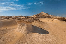
Wind erosional landforms include pediments, pediplains, playas, deflation hollows, caves, mushroom rocks, etc. Wind erosion is a geologic process driven by the movement of air masses across the Earth’s surface. This process involves the removal of surface materials such as soil, sand, and rocks due to the abrasive action of wind-blown particles.
Mechanism of Arid Erosion
- When water evaporates at the ground surface, calcite cements the surrounding sediments together, forming arid landforms.
- In other words, arid landforms are the result of a series of interrelated processes working together.
- Aridity is in fact caused by the lack of precipitation and a high rate of evaporation.
- Desert rocks that are devoid of vegetation are exposed to mechanical and chemical weathering processes as a result of extreme diurnal temperature variations and the action of wind.
Weathering
- Mechanical weathering and Chemical weathering dominate in arid landforms
- Without abundant water in the arid environment, the chemical breakdown of rocks proceeds extremely slowly.
- However, the mechanical breakdown of rock proceeds relatively quickly in the arid climate.
Wind Action
- As an erosional agent, the wind is more effective in arid regions than humid regions as in arid regions, there is little moisture and vegetation to bind the loose material.
- The wind action creates a number of interesting erosional and depositional features in the deserts.
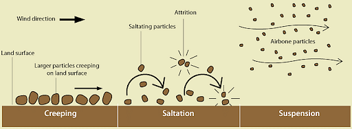
- Wind erosion is carried out in desert areas in three ways – Deflation, Abrasion, and Attrition.
Stages of Erosional Process by Wind
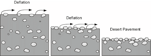
Deflation
- This stage includes picking up and blowing away loose items like dirt and rock fragments from the ground by high-speed winds.
- Blowing capacity is mostly determined by the size of the material being lifted from the ground.
- Finer dust and sands can be transported miles from their source and deposited far outside the desert borders.
- Deflation causes the land surface to sink, forming enormous depressions known as deflation hollows.
- Hollows are sometimes generated as a result of this process, which is typically minor in size but can range in diameter from 1 to 15 kilometers.
Abrasion
- High-speed winds carry soil and rock particles, as well as small rocks and other debris.
- These are also known as wind tools.
- The wind sandblasts rock surfaces by hurling sand particles on them.
- This debris acts like sandpaper, causing erosion and friction on adjacent rocks, a process called abrasion.
- Rock surfaces are scratched, polished, and worn away as a result of this.
- The amount of material that the wind can carry is greatest near the base of the rocks, hence abrasion is most effective there.
- This helps to explain why telegraphic poles in the desert are covered with metal for a foot or two above the ground.
Attrition
- Sand particles carried by the wind begin a friction process within themselves, reducing their size. This is referred to as attrition.
- High-speed winds speed up the erosional process.
- Hard rocks, on the other hand, take a long time to erode, whereas soft rocks do so quickly.
- Small particles can travel very long distances, whereas large pebbles and stones (with a radius of 5 to 8 centimeters) can only travel a short distance.
Water Action
- Many features of deserts owe their formation to mass wasting and running water as sheet floods.
- The desert rocks devoid of vegetation, exposed to mechanical and chemical weathering processes due to drastic diurnal temperature changes, decay faster.
- These weathered materials are easily carried away by torrential rainfall.
Landforms of Wind Erosion
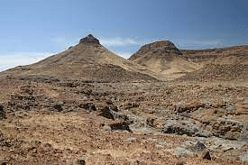
Pediments
- A pediment is a gently sloping erosion surface or low-relief plain at the base of a receding mountain front in an arid or semiarid region.
- A pediment is often covered by a thin, discontinuous veneer of soil and alluvium produced from upland areas, which is underlain by bedrock.
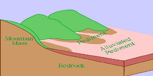
Pediplains
- Pediplains are formed when high relief features in deserts are lowered to low featureless plains due to wind activity.
- The convergence of pediments forms a pediplain, which is a largely flat landscape.
- Pediplanation is the term for the process by which pediplains form.
Deflation Hollows
- The removal of loose particles from the ground by the action of the wind is known as deflation.
- Winds can cause minor depressions in the ground by blowing away unconsolidated materials.
- Minor faulting can also generate depressions, and oncoming winds can erode the weaker rocks until they reach the water table.
- In the deflation hollows or depressions, water seeps out, generating oases or wetlands.
- Large sections of the western United States, which had been stripped of their natural vegetation for farming, were utterly deflated when strong winds carried materials as dust storms, laying waste crops and causing the Great Dust Bowl.
Playas
- A playa (also known as a pan, flat, or dry lake) is a depression with a flat floor found in interior desert basins.
- They are found near the beaches in dry and semi-arid locations.
- Playas are occasionally covered by water that slowly filters into the groundwater system or evaporates into the atmosphere, causing salt, sand, and mud to accumulate along the bottom and around the margins of the depression.
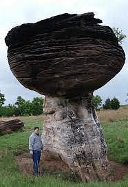
Mushroom Rocks
- A mushroom rock, also known as a rock pedestal, pedestal rock, or mushroom table, is a naturally formed rock that resembles a mushroom in shape.
- These rocks can be deformed in a variety of ways, including erosion and weathering, glacial action, or a sudden disturbance.
- These geomorphic landforms are most common in dry areas with little vegetation to obstruct aeolian particle movement, frequent high winds, and a steady but not excessive supply of sand.
- Winds convey a greater volume of sand and rock particles near the ground in deserts, causing more bottom erosion in overlying rocks than top erosion.
Mesas (Table) and Buttes
- Mesa is a Spanish word that translates to “table.”
- It’s a flat, table-like landmass with a tough horizontal top layer and steep edges.
- The hard stratum on the surface resists both wind and water denudation, protecting the underlying layer of rocks from erosion.
- Continual denudation over time may convert Mesas in a given area to isolated flat-topped hills known as Buttes.

Zugen
- A layer of soft rocks lies beneath a top layer of more resistant rocks in tabular masses.
- The wind’s erosional action on soft and resistant rock surfaces carves them into strange-looking ridge and furrow landscapes.
- Mechanical weathering causes them to form by causing surface rock joints to open up.
- Wind abrasion eats deeper through the underlying softer layer, forming deep furrows.
- As ridges or Zugen, the hard rock rises above the furrows.
- Zugen can stand anywhere between 10 and 100 feet above the sunken furrows.
- The Zugen is gradually lowered and the furrow is widened as a result of wind abrasion.
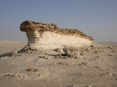
Yardangs
- Yardangs resemble Zugen in appearance, however, instead of horizontal layers on top of one another, the hard and soft rocks of Yardangs are arranged in vertical bands.
- The rocks are oriented in the direction of the wind.
- Wind abrasion separates the steep-sided overhanding ridges of hard rock known as Yardangs from the bands of softer rocks by excavating them into long, narrow passageways.
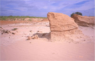
Isenberg (Island Mountain)
- They are essentially isolated remnant hills that rise suddenly from the ground level, with steep slopes and rounded crowns.
- They’re usually made of granite or gneiss.
- Are most likely remnants of an earlier plateau that has been nearly completely eroded away.
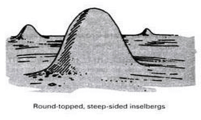
Conclusion
Wind erosion occurs primarily in arid and semi-arid regions where vegetation is sparse. The process involves the transport of fine particles through suspension, saltation (bouncing), and creep. Windblown particles can reach speeds of up to 60 miles per hour, causing abrasion and erosion.
Glaciers
- A glacier is a huge mass of ice that moves slowly over land. The term “glacier” comes from the French word glace (glah-SAY), which means ice. Glaciers are often called “rivers of ice.”
- Glaciers normally assume the shape of a tongue, broadest at the source & becoming narrower downhill.
- Though glacier is not liquid, but it moves gradually under the continual pressure from the snow accumulated above.
- The rate of movement is greatest in the middle where there is little obstruction.
- The sides & bottom are held back by the frictions due to valley sides & valley floors.
- If a row of stakes is planted across a glacier in a straight line, they will eventually take a curved shape down the valley, showing that the glacier moves faster at the center than at the sides.
- Glacial Landforms can be found in locations that currently have no active glaciers or glaciation processes.
- Glaciers fall into two groups: alpine glaciers and ice sheets
- Alpine glaciers
- Alpine glaciers form on mountainsides and move downward through valleys.
- Sometimes, alpine glaciers create or deepen valleys by pushing dirt, soil, and other materials out of their way.
- Alpine glaciers are found in high mountains of every continent except Australia (although there are many in New Zealand).
- The Gorner Glacier in Switzerland and the Furtwangler Glacier in Tanzania are both typical alpine glaciers.
- Alpine glaciers are also called valley glaciers or mountain glaciers.
- Ice sheets
- Ice sheets, unlike alpine glaciers, are not limited to mountainous areas. They form broad domes and spread out from their centers in all directions.
- As ice sheets spread, they cover everything around them with a thick blanket of ice, including valleys, plains, and even entire mountains.
- The largest ice sheets, called continental glaciers, spread over vast areas. Today, continental glaciers cover most of Antarctica and the island of Greenland.
- Massive ice sheets covered much of North America and Europe during the Pleistocene time period. This was the last glacial period, also known as the Ice Age. Ice sheets reached their greatest size about 18,000 years ago. As the ancient glaciers spread, they carved and changed the Earth’s surface, creating many of the landscapes that exist today.
- During the Pleistocene Ice Age, nearly one-third of the Earth’s land was covered by glaciers. Today, about one-tenth of the Earth’s land is covered by glacial ice.

The Ice-Age and Ice masses
- An ice age is a long period of reduction in the temperature of Earth’s surface and atmosphere, resulting in the presence or expansion of continental and polar ice sheets and alpine glaciers.
- Earth’s climate alternates between ice ages and greenhouse periods, during which there are no glaciers on the planet.
- Earth is currently in the Quaternary glaciation.
- Today, only 2 major ice caps are present in this world – Antarctica & Greenland, along with many highlands above the snowline surviving in the world.
- Ice from the ice cap creeps out in all directions to escape as glaciers.
- When the ice sheets reaches down to the sea they float as ice shelves in polar waters.
- When ice sheets break into individual blocks, these are called icebergs.
- While afloat in the sea, only 1/9th of the iceberg’s mass is visible above the surface.
- They diminish in size when reaching warm waters & eventually melted, dropping the rock debris that was frozen inside them on the sea bed.
- Permanent snowfield is sustained by heavy snowfall in winters & ineffective snow melting & evaporation in summers as part of snow that melt during the day is refrozen during the night.
- This refreezing process repeats until it forms a hard, granular substance known as neve or firn.
- Owing to the gravitational forces, neve of the upland snowfield is drawn towards the valley below, which marks the beginning of the flow of glacier (river of ice).
Glacial Cycle of Erosion
- Youth:
- The stage is marked by the inward cutting activity of ice in a cirque. Aretes and horns are emerging. The hanging valleys are not prominent at this stage.
- Maturity:
- The valley glacier gets transformed into a trunk glacier and hanging valleys start emerging. The opposite cirques come closer and the glacial trough acquires a stepped profile that is regular and graded.
- Old Age:
- The emergence of a ‘U’-shaped valley marks the beginning of old age. An outwash plain with features such as eskers, kame terraces, drumlins, kettle holes, etc. is a prominent development. The opposite cirques coalesce and the summit heights are greatly reduced. Mountain tops become rounded.
Glacial Landforms
- Glaciations generally gives rise to erosional features in the highlands & depositional features on lowlands
- It erodes its valley by two processes viz. plucking & abrasion.
- Plucking: Glacier freezes the joints & beds of underlying rocks, tears out individual blocks & drags them away.
- Abrasion: Glacier scratches, scrapes, polishes & scours the valley floor with the debris frozen into it.
Glacial Landforms – Erosional

Snout or Glacier terminus
- A glacier terminus, toe, or snout, is the end of a glacier at any given point in time.
- The terminus is the usually the lowest end of glacier.
Corrie, Cirque or cwm
- The downslope movement of a glacier from its snow-covered valley head & the the intensive shattering of the upland slopes, tend to produce a depression where neve or firn accumulates.
- Plucking & abrasion further deepen the depression into a steep horse shoe-shaped basin called Cirque (in French), cwm (in wales) & Corrie (in Scotland)
- There is a rocky ridge at the exit of the corrie & when the ice eventually melts, water collect behind this barrier known as Corrie Lake or tarn.

Cols
- Cols form when two cirque basins on opposite sides of the mountain erode the arête dividing them.
- Cols create saddles or passes over the mountain.
Horns
- Horns are a single pyramidal peak formed when the summit is eroded by cirque basins on all sides.

Aretes and Pyramidal Peaks
- When two corries cut back on opposite sides of the mountain, knife edged ridges are formed called arêtes
- When three or more cirques cut back together, recession will form an angular horn or pyramidal peak.

Bergschrund
- At the head of a glacier, where it begins to leave the snowfield of a corrie, a deep vertical crack opens up called a Bergschrund or Rimaye
- This happens in summer when although the ice continues to move out of the corrie, there is no new snow to replace it
- In some cases, not one but several such cracks occur which present a major obstacle to climbers
- Further down, where the glacier negotiates a bend or a precipitous slope, more crevasses or cracks are formed.

Roche moutonnée
- Basically, a resistant residual rock hummock or mound, striated by the ice movement.
- Its upstream or stoss side is smoothened by abrasion & its downward or leeward side is roughened by plucking & is much steeper.
- It is believed that plucking may have occurred on the leeward side due to a reduction in pressure of the glacier moving over the stoss slope
- Therefore providing the opportunity for water to refreeze on the lee side and pluck the rock away.

Crag and tail
- A crag and tail is a larger rock mass than a Roche moutonnee
- Like a Roche moutonnee, it is formed from a section of rock that was more resistant than its surroundings.
- Crag is a mass of hard rock with a steep slope on the upward side, which protects the softer leeward slope from being completely worn down by the oncoming ice.
- It therefore has a gentle tail strewn with the eroded rock debris.

Nunatak
- A nunatak is the summit or ridge of a mountain that protrudes from an ice field or glacier that otherwise covers most of the mountain or ridge. They are also called glacial islands.
- Nunatak is a mountain peak or other rock formation that is exposed above a glacier or ice sheet.
Paternoster Lakes
- A paternoster lake is one of a series of glacial lakes connected by a single stream or a braided stream system.
- Paternoster lakes are formed in the low depression of a U-shaped valley.
- Paternoster lakes are created by recessional moraines, or rock dams, that are formed by the advance and subsequent upstream retreat and melting of the ice.
U shaped glacial Troughs & Ribbon lakes
- Glaciers on their downward journey are fed by several corries scratches & grind the bedrock with straightening out any protruding spurs.
- The interlocking spurs are thus blunted to form truncated spurs with the floor of the valley deepened.
- Hence, the valley which has been glaciated takes the characteristic of U shape, with a wide flat floor & very steep sides.
- After the disappearance of the ice, the deep sections, of these long, narrow glacial troughs may be filled with water forming Ribbon lakes also known as Trough lakes or Finger Lakes.
Hanging Valleys
- The main valley is eroded much more than the tributary valley as it contains a much larger glacier.
- After the ice has been melted, a tributary valley hangs above the main valley & plunges down as a waterfall. Such Tributary valleys are termed as hanging valleys.
- Hanging valleys may form a natural head of water for generating hydroelectric power.

Rock Basins and Rock Steps
- A glacier erodes & excavates the bed rock in an irregular manner.
- The unequal excavation gives rise to many rock basins later filled by lakes in valley trough.
- Where a tributary valley joins a main valley, the additional weight of ice in the main valley cuts deeper into the valley floor & deepest at the point of convergence forming rock steps.
- A series of such rock steps may also be formed due to different degrees of resistance to glacial erosion of the bedrocks.
Fjord
- If the glacier flows right down to the sea, it drops its load of moraine in the sea.
- If sections break off as icebergs, moraine material will only be dropped when they melt
- Where the lower end of the trough is drowned by the sea, it forms a deep, steep side inlet called a Fjord, a typical of Norway & Chilean coast.
- Fjords are common in Norway, Greenland and New Zealand.

Glacial Landforms – Depositional

Boulder clay or Glacial till
- This is an unsorted glacial deposit comprising a range of eroded materials such as boulders, sticky clays & fine rock flour.
- It is spread out in sheets, not mounds, & forms gently undulating till or drift plains with monotonous landform.
- The degree of fertility of such glacial plains depends very much on the composition of the depositional materials.
Erratics
- Boulders of varying sizes are transported by ice & left stranded in the regions of deposition when the ice melted, called erratics because they are composed of materials entirely different from those of the regions in which they have been transported.
- Useful in tracing the source & direction of ice movements but their presence in large numbers causes hindrance in farming.
- Also known as perched blocks as sometimes they are found perched in precarious positions as the ice dropped them.
Moraines
- Moraines are made up of pieces of rock that are shattered by frost action, embedded in the glaciers & brought down the valley.
- Those that fall on the sides of the glacier form lateral moraines.
- When two glaciers converge, their inside lateral moraines unite to form a medial moraine.
- The rock fragments which are dragged along, beneath the frozen ice, are dropped when the glacier melts & spread across the floor of the valley as ground moraine.
- The glacier eventually melts on reaching the foot of the valley & the pile of transported materials left behind at the snout is terminal moraine or end moraine.
- The deposition of end moraines may be in several succeeding waves, as the ice may melt back by stages so that a series of recessional moraines are formed.

Drumlins
- Drumlins are oval-shaped hills, largely composed of glacial drift, formed beneath a glacier or ice sheet and aligned in the direction of ice flow.
- They are widespread in formerly glaciated areas and are especially numerous in Canada, Ireland, Sweden, and Finland.
- They are low hills up to 1.5 km long and 60 mm tall & appear steeper on the onset side & taper off at the leeward side.
- They are arranged diagonally & commonly referred as a basket of eggs topography.
- ′Basket of egg topography′ is the topography of drumlins, which are generally found in clusters.
- Drumlin fields are areas with numerous drumlins.
Eskers
- Eskers are the sinuous ridges composed of glacial material mainly sands & gravel deposited by meltwater currents in glacial tunnels
- Glacial tunnels mark the former sites of sub glacial melt water streams
- Their orientation is generally parallel to the direction of glacial flow, and they sometimes exceed 100 kilometers in length.

Outwash Plains
- Made up of fluvio glacial deposits washed out from the terminal moraines by the streams of stagnant ice mass.
- The melt waters sort & redeposit the material mainly consisted of layers of sand and other fine sediments.
- Such plains with their sandy soils are often used for specialized kinds of agriculture, such as the potato.
Kettle lake
- Depressions are formed when the deposition takes place in the form of alternating ridges.
- Shallow, sediment-filled bodies of water formed by retreating glaciers.
Kames
- Small rounded hillocks of sand & gravel which cover part of the plain.
- Kames are often associated with kettles, and this is referred to as kame & kettle topography.
- Kame is also called Hummocks.
